Texas Spring 2016
Moderator: S2k Moderators
Forum rules

The posts in this forum are NOT official forecast and should not be used as such. They are just the opinion of the poster and may or may not be backed by sound meteorological data. They are NOT endorsed by any professional institution or STORM2K.

Re: Texas Spring 2016
Nam is a model, close to in time to an event usually does well, PDS is Potentially Dangerous Situation tornado conditions. It's predicted now.
0 likes

Re: Texas Spring 2016
Where is it predicted? can you link?
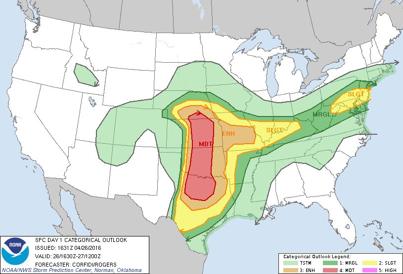
SPC only has a moderate risk just north of DFW
SPC only has a moderate risk just north of DFW
0 likes
-
gboudx

- S2K Supporter

- Posts: 4090
- Joined: Thu Sep 04, 2003 1:39 pm
- Location: Rockwall, Tx but from Harvey, La
Re: Texas Spring 2016
Here's Steve McCauleys update
The stage is set for a potentially damaging severe weather event today from central Texas north into southern Nebraska. Here is the latest estimate on what to expect here in north Texas. NOTE: This is a very complicated setup, so we must allow for modifications to these details. In other words, changes are likely to occur!
Isolated supercell storms with very large hail, damaging winds, torrential rainfall, and a tornado threat will fire west of the Metroplex by late afternoon. They will merge into a BROKEN line as they push into the Metroplex after 6 PM. Since the line will not likely be solid, there will be locations that will slip through the cracks and not see anything at all. But the storms that do manage to move in will be strong to severe with perhaps somewhat smaller hail but still carrying the damaging wind, torrential rainfall, and isolated tornado threat.
(As you all know, the main tornado threat will be to our north in Oklahoma and Kansas, but it certainly CANNOT be ruled out here in north Texas)
After this first round of storms goes through, a SOLID line of storms will then form to our west and sweep the Metroplex Tuesday night and exit the area after 1:00 or 2:00 AM. It is hoped the first round of storm will knock a lot of the energy out of the atmosphere so that the second line won't be as intense. BUT ... if the first BROKEN line of storms has too many holes in it, the second line could be quite intense as well.
Stay tuned for what will almost assuredly be changes to this outlook, but this is the best guess right now.
0 likes
-
TheProfessor

- Professional-Met

- Posts: 3506
- Age: 29
- Joined: Tue Dec 03, 2013 10:56 am
- Location: Wichita, Kansas
Re: Texas Spring 2016
Looks like there is a gravity wave on satellite in West Texas, this could complicate things but it looks like it's moving through fast so hopefully it doesn't cause trouble.
Edit: I don't know how this could interact with possible storms, I just know it was possibly a gravity wave that helped make the Jarrell Texas storm what it was. Hopefully it doesn't slow down.
Edit: I don't know how this could interact with possible storms, I just know it was possibly a gravity wave that helped make the Jarrell Texas storm what it was. Hopefully it doesn't slow down.
0 likes
An alumnus of The Ohio State University.
Your local National Weather Service office is your best source for weather information.
Your local National Weather Service office is your best source for weather information.


Re: Texas Spring 2016
Hrrr (though hasn't been great of late, did get storms right yesterday just happened hundreds of miles further south) quickly has a solid MCS line crossing late this evening. Million dollar question is what singular cell ahead will form if any and dump mammoth hail and/or brief tornado? It will take some time as cap is present this morning.
6pmish

9pmish

6pmish
9pmish
0 likes
The above post and any post by Ntxw is NOT an official forecast and should not be used as such. It is just the opinion of the poster and may or may not be backed by sound meteorological data. It is NOT endorsed by any professional institution including Storm2k. For official information, please refer to NWS products.
Help support Storm2K!
-
cheezyWXguy

- Category 5

- Posts: 6282
- Joined: Mon Feb 13, 2006 12:29 am
- Location: Dallas, TX
Re: Texas Spring 2016
Ntxw wrote:Hrrr (though hasn't been great of late, did get storms right yesterday just happened hundreds of miles further south) quickly has a solid MCS line crossing late this evening. Million dollar question is what singular cell ahead will form if any and dump mammoth hail and/or brief tornado? It will take some time as cap is present this morning.
What is also interesting to note though, is that it basically forms this MCS all the way into Kansas. I was under the impression that most storms would remain discrete north of the Red River, or at least the Norman/OKC area since the tornado threat was determined to be so much higher up there. NAM 4km on the other hand, continues to paint more of a cluster-of-random-supercells look, and again has a PDS TOR hazard over the immediate DFW area at hour 15. Do you think the HRRR is forming this into an MCS to early, or that the NAM is holding off on it for too long?
0 likes
Re: Texas Spring 2016
cheezyWXguy wrote:What is also interesting to note though, is that it basically forms this MCS all the way into Kansas. I was under the impression that most storms would remain discrete north of the Red River, or at least the Norman/OKC area since the tornado threat was determined to be so much higher up there. NAM 4km on the other hand, continues to paint more of a cluster-of-random-supercells look, and again has a PDS TOR hazard over the immediate DFW area at hour 15. Do you think the HRRR is forming this into an MCS to early, or that the NAM is holding off on it for too long?
4k NAM can be overzealous sometimes. It may be due to resolution but I'm not certain. HRRR can be too happy with storm initiation thus quickly congealing it. Perhaps a blend of the two, an MCS will form as it approaches I-35 though, if they fire hard out west the more likely that is to happen. If they fire closer to us the more discrete they will be probably.
One caveat is the gravity waves mentioned this morning. Hard to know what they will do.
0 likes
The above post and any post by Ntxw is NOT an official forecast and should not be used as such. It is just the opinion of the poster and may or may not be backed by sound meteorological data. It is NOT endorsed by any professional institution including Storm2k. For official information, please refer to NWS products.
Help support Storm2K!
Help support Storm2K!
-
cheezyWXguy
- Category 5
- Posts: 6282
- Joined: Mon Feb 13, 2006 12:29 am
- Location: Dallas, TX
Re: Texas Spring 2016
Ntxw wrote:cheezyWXguy wrote:What is also interesting to note though, is that it basically forms this MCS all the way into Kansas. I was under the impression that most storms would remain discrete north of the Red River, or at least the Norman/OKC area since the tornado threat was determined to be so much higher up there. NAM 4km on the other hand, continues to paint more of a cluster-of-random-supercells look, and again has a PDS TOR hazard over the immediate DFW area at hour 15. Do you think the HRRR is forming this into an MCS to early, or that the NAM is holding off on it for too long?
4k NAM can be overzealous sometimes. It may be due to resolution but I'm not certain. HRRR can be too happy with storm initiation thus quickly congealing it. Perhaps a blend of the two, an MCS will form as it approaches I-35 though, if they fire hard out west the more likely that is to happen. If they fire closer to us the more discrete they will be probably.
One caveat is the gravity waves mentioned this morning. Hard to know what they will do.
Thanks for the reply. Speak of the devil, the 13z HRRR looks broken/discrete for a bit longer than the 12z did. And with the gravity wave, yeah, I guess only time will tell.
0 likes
-
TheProfessor
- Professional-Met
- Posts: 3506
- Age: 29
- Joined: Tue Dec 03, 2013 10:56 am
- Location: Wichita, Kansas
Re: Texas Spring 2016
Here are the Gravity Waves at 14:45z A new small line of the wave actually developed west of this one.

image hosting 30 mb
image hosting 30 mb
0 likes
An alumnus of The Ohio State University.
Your local National Weather Service office is your best source for weather information.
Your local National Weather Service office is your best source for weather information.
-
cheezyWXguy
- Category 5
- Posts: 6282
- Joined: Mon Feb 13, 2006 12:29 am
- Location: Dallas, TX
Re: Texas Spring 2016
TheProfessor wrote:Here are the Gravity Waves at 14:45z A new small line of the wave actually developed west of this one.
[img]http://s32.postimg.org/k7upyvj45/Gravity_waves_1.jpg[
image hosting 30 mb
What implications do you think these waves might have on the storms this afternoon?
0 likes
-
TheProfessor
- Professional-Met
- Posts: 3506
- Age: 29
- Joined: Tue Dec 03, 2013 10:56 am
- Location: Wichita, Kansas
Re: Texas Spring 2016
cheezyWXguy wrote:TheProfessor wrote:Here are the Gravity Waves at 14:45z A new small line of the wave actually developed west of this one.
[img]http://s32.postimg.org/k7upyvj45/Gravity_waves_1.jpg[
image hosting 30 mb
What implications do you think these waves might have on the storms this afternoon?
I don't know a lot about gravity waves, they're causing elevated storms to form in Oklahoma. The elevated storms shouldn't repress the severe weather and in fact could form some outflow boundaries that could increase severe weather later on. From what I have gathered on the gravity waves is that they show the potency of the storm system and could be a sign that the CAP will break later today.
0 likes
An alumnus of The Ohio State University.
Your local National Weather Service office is your best source for weather information.
Your local National Weather Service office is your best source for weather information.
-
cheezyWXguy
- Category 5
- Posts: 6282
- Joined: Mon Feb 13, 2006 12:29 am
- Location: Dallas, TX
Re: Texas Spring 2016
TheProfessor wrote:cheezyWXguy wrote:TheProfessor wrote:Here are the Gravity Waves at 14:45z A new small line of the wave actually developed west of this one.
[img]http://s32.postimg.org/k7upyvj45/Gravity_waves_1.jpg[
image hosting 30 mb
What implications do you think these waves might have on the storms this afternoon?
I don't know a lot about gravity waves, they're causing elevated storms to form in Oklahoma. The elevated storms shouldn't repress the severe weather and in fact could form some outflow boundaries that could increase severe weather later on. From what I have gathered on the gravity waves is that they show the potency of the storm system and could be a sign that the CAP will break later today.
Thanks for the info. They do look interesting on vis satellite.
I'm having trouble trusting the HRRR on MCS development tonight. It seems intent on developing a large number of storms and having them merge so quickly into a solid line, yet out ahead of the line, the fcst sounding for Dallas has shown PDS TOR for the last 2 runs in a row. With such favorable shear profiles over the metro even later this evening, it seems like storms would stay discrete for longer than the model is advertising. Someone please correct me if I'm interpreting this wrong.
0 likes
-
cheezyWXguy
- Category 5
- Posts: 6282
- Joined: Mon Feb 13, 2006 12:29 am
- Location: Dallas, TX
-
gboudx
- S2K Supporter
- Posts: 4090
- Joined: Thu Sep 04, 2003 1:39 pm
- Location: Rockwall, Tx but from Harvey, La
Re: Texas Spring 2016
cheezyWXguy wrote:SPC just extended the MDT risk to include much of NTX
Yep
0 likes


-
Annie Oakley

- Category 5
- Posts: 1103
- Joined: Tue Jul 31, 2007 12:54 pm
- Location: Texas
Re: Texas Spring 2016
Jarodm12 wrote:What does that mean.. NAM PDS TOR?
I didn't know what it means either. I hope a MET can chime in and give us a 'civilian' explanation. In the meantime I found this...............
http://www.spc.noaa.gov/publications/dean/pdswatch.pdf
I'm getting scared for tonight. What's a good thing to put on a car windshield to protect it while parked?
0 likes
-
TheProfessor
- Professional-Met
- Posts: 3506
- Age: 29
- Joined: Tue Dec 03, 2013 10:56 am
- Location: Wichita, Kansas
Re: Texas Spring 2016
Annie Oakley wrote:Jarodm12 wrote:What does that mean.. NAM PDS TOR?
I didn't know what it means either. I hope a MET can chime in and give us a 'civilian' explanation. In the meantime I found this...............
http://www.spc.noaa.gov/publications/dean/pdswatch.pdf
I'm getting scared for tonight. What's a good thing to put on a car windshield to protect it while parked?
A PDS TOR means there is a confirmed tornado and it typically gets a PDS warning if Damage has been seen in an Urban area. PDS stands for Particularly Dangerous Situation. The Saving Grace for the Metro tonight might be that the storms form out into a line. However if the Storms stay as individual cells or if individual cells form ahead of the line it could get really bad. The best Tornado parameters arrive after 7PM Central, hopefully the storms have already formed a line by then.
0 likes
An alumnus of The Ohio State University.
Your local National Weather Service office is your best source for weather information.
Your local National Weather Service office is your best source for weather information.
-
cheezyWXguy
- Category 5
- Posts: 6282
- Joined: Mon Feb 13, 2006 12:29 am
- Location: Dallas, TX
Re: Texas Spring 2016
Annie Oakley wrote:Jarodm12 wrote:What does that mean.. NAM PDS TOR?
I didn't know what it means either. I hope a MET can chime in and give us a 'civilian' explanation. In the meantime I found this...............
http://www.spc.noaa.gov/publications/dean/pdswatch.pdf
I'm getting scared for tonight. What's a good thing to put on a car windshield to protect it while parked?
I'm not a met, but as I've come to interpret it, PDS TOR from model output basically means that in that location, it forecasts very favorable conditions for a tornado to occur. It is by no means official, and just like all other model data, has the potential to change from run to run. Because of this, it holds far less weight than an official PDS watch from the NWS would. The reason this keeps popping up in discussion at the moment is that the NAM 4km and HRRR have had a few runs showing conditions in NTX that prompt this label. IMO, its something that should prompt attention, but certainly not alarm. We just won't know how favorable conditions will be until they begin to unfold, but it doesn't hurt to be prepared.
0 likes
Re: Texas Spring 2016
The moderate risk expansion south is due to increased confidence in wind and very large hail by the SPC. Tor hatched area looks to remain the same. A culprit might be a bow echo type system tonight at least for wind.
0 likes
The above post and any post by Ntxw is NOT an official forecast and should not be used as such. It is just the opinion of the poster and may or may not be backed by sound meteorological data. It is NOT endorsed by any professional institution including Storm2k. For official information, please refer to NWS products.
Help support Storm2K!
Help support Storm2K!
Return to “USA & Caribbean Weather”
Who is online
Users browsing this forum: No registered users and 84 guests