Seasonal Indicators (Beyond Day 16): Instability / SST's / MSLP / Steering / Sal

This is the general tropical discussion area. Anyone can take their shot at predicting a storms path.

Moderator: S2k Moderators

Forum rules

The posts in this forum are NOT official forecasts and should not be used as such. They are just the opinion of the poster and may or may not be backed by sound meteorological data. They are NOT endorsed by any professional institution or STORM2K. For official information, please refer to products from the National Hurricane Center and National Weather Service.

Help Support Storm2K
Message
Author
User avatar
Hurricaneman
Category 5
Category 5
Posts: 7351
Age: 45
Joined: Tue Aug 31, 2004 3:24 pm
Location: central florida

Re: 2016 indicators: Instability / SST's / MSLP / Steering / Sal

#121 Postby Hurricaneman » Thu Mar 31, 2016 10:38 pm

Alyono wrote:the September CanSips is incredibly favorable, after an unfavorable June. That pattern could yield 7-10 Atlantic storms in September

Thankfully, it is the Canadian


One thing i agree with you on is the EPAC MDR SSTAs are going to hold the key to the hurricane season and we'll know more by June
0 likes   

User avatar
SFLcane
S2K Supporter
S2K Supporter
Posts: 10163
Age: 47
Joined: Sat Jun 05, 2010 1:44 pm
Location: Lake Worth Florida

Re: 2016 indicators: Instability / SST's / MSLP / Steering / Sal

#122 Postby SFLcane » Thu Mar 31, 2016 10:43 pm

Well spoke have spoken to phil k. few times on twitter and he seems not in a favor of a busy year infact I suspect he will be calling for below average season in his april update. Those cold anomalies starting to show up near Africa are ugly.

Image
0 likes   

tolakram
Admin
Admin
Posts: 20009
Age: 62
Joined: Sun Aug 27, 2006 8:23 pm
Location: Florence, KY (name is Mark)

Re: 2016 indicators: Instability / SST's / MSLP / Steering / Sal

#123 Postby tolakram » Fri Apr 01, 2016 8:30 am

Why would cold anomalies in the eastern MDR make a season slower rather than shift development west? Honest question.

I think that a more damning indication of poor conditions is the continued well below normal vertical instability. Perhaps the two are linked.

Image
0 likes   
M a r k
- - - - -
Join us in chat: Storm2K Chatroom Invite. Android and IOS apps also available.

The posts in this forum are NOT official forecasts and should not be used as such. Posts are NOT endorsed by any professional institution or STORM2K.org. For official information and forecasts, please refer to NHC and NWS products.

User avatar
Ntxw
Storm2k Moderator
Storm2k Moderator
Posts: 22785
Joined: Wed Oct 21, 2009 6:34 pm
Location: DFW, Texas

Re: 2016 indicators: Instability / SST's / MSLP / Steering / Sal

#124 Postby Ntxw » Fri Apr 01, 2016 8:38 am

Cold anomalies in the eastern MDR that links or rings up to the cold north/northeastern Atlantic is -AMO enhancement

+AMO (in general) is ring of warmth in the eastern Atlantic and cold western Atlantic, though there are other forms of it such as an overall warmer Atlantic. However before we use this you must take into consideration SST's change seasonally. Cold now does not mean cold later. Have to use it in context of longer periods than daily or weekly

Using this standard the single most significant shift is the far north Atlantic of the expanding cold waters (Greenland to Europe). It came in 2013 and has grown since favoring a predominant +NAO. The last big -NAO during hurricane season was Sandy before the cold waters kicked in and flipped the switch up there
0 likes   
The above post and any post by Ntxw is NOT an official forecast and should not be used as such. It is just the opinion of the poster and may or may not be backed by sound meteorological data. It is NOT endorsed by any professional institution including Storm2k. For official information, please refer to NWS products.

  Help support Storm2K!
Help Support Storm2K

User avatar
SFLcane
S2K Supporter
S2K Supporter
Posts: 10163
Age: 47
Joined: Sat Jun 05, 2010 1:44 pm
Location: Lake Worth Florida

Re: 2016 indicators: Instability / SST's / MSLP / Steering / Sal

#125 Postby SFLcane » Fri Apr 01, 2016 9:34 am

And those expanding cold anomalies in North Atlantic are not indicative of a busy season per Phil k. Personally I'd take any season forecast in the coming months (this year) with a huge grain of salt as it can go either way. We shall see
0 likes   

WeatherEmperor
S2K Supporter
S2K Supporter
Posts: 4806
Age: 41
Joined: Thu Sep 04, 2003 2:54 pm
Location: South Florida

Re: 2016 indicators: Instability / SST's / MSLP / Steering / Sal

#126 Postby WeatherEmperor » Fri Apr 01, 2016 9:37 am

The below average instability could be linked to drier air in the atmosphere. It makes sense because drier air is stable air whereas moist air is more unstable. Maybe somebody can post some water vapor or whatever information so we can see how much dry air is present.

Also, while it is true that the far eastern MDR is showing cooler than normal anomalies, the western MDR is showing very warm anomalies so we could see increased development chances closer to home
0 likes   

WeatherEmperor
S2K Supporter
S2K Supporter
Posts: 4806
Age: 41
Joined: Thu Sep 04, 2003 2:54 pm
Location: South Florida

Re: 2016 indicators: Instability / SST's / MSLP / Steering / Sal

#127 Postby WeatherEmperor » Fri Apr 01, 2016 9:40 am

I agree so much with this. There are so many different factors playing so many different roles that its so difficult to say how active the season will really be. For me personally I am going to go with an Average season to olay it safe because really it wont take much for it to go either way

SFLcane wrote:And those expanding cold anomalies in North Atlantic are not indicative of a busy season per Phil k. Personally I'd take any season forecast in the coming months (this year) with a huge grain of salt as it can go either way. We shall see
0 likes   

User avatar
SFLcane
S2K Supporter
S2K Supporter
Posts: 10163
Age: 47
Joined: Sat Jun 05, 2010 1:44 pm
Location: Lake Worth Florida

Re: 2016 indicators: Instability / SST's / MSLP / Steering / Sal

#128 Postby SFLcane » Fri Apr 01, 2016 9:48 am

Look at dr Ventrice Twitter...(In terms of the tropical base state, September is looking juicy for strong Atlantic Hurricanes.)

https://pbs.twimg.com/media/Ce9qpLPWsAQXF2X.jpg:large
0 likes   

User avatar
WPBWeather
S2K Supporter
S2K Supporter
Posts: 535
Age: 67
Joined: Thu Jul 18, 2013 12:33 pm

Re: 2016 indicators: Instability / SST's / MSLP / Steering / Sal

#129 Postby WPBWeather » Fri Apr 01, 2016 9:54 am

:uarrow: Again, the "cold" spots you reference may not be real and seem to jump from run to run hundreds of miles. I hope for a slow year too, but these data are not sufficient to warrant anything but speculation at this point.
0 likes   

Alyono
Professional-Met
Professional-Met
Posts: 6961
Joined: Fri Apr 26, 2013 3:52 pm
Location: Texas Coast

Re: 2016 indicators: Instability / SST's / MSLP / Steering / Sal

#130 Postby Alyono » Fri Apr 01, 2016 9:54 am

SFLcane wrote:Look at dr Ventrice Twitter...(In terms of the tropical base state, September is looking juicy for strong Atlantic Hurricanes.)

https://pbs.twimg.com/media/Ce9qpLPWsAQXF2X.jpg:large


CANADIAN MODEL
0 likes   

User avatar
SFLcane
S2K Supporter
S2K Supporter
Posts: 10163
Age: 47
Joined: Sat Jun 05, 2010 1:44 pm
Location: Lake Worth Florida

Re: 2016 indicators: Instability / SST's / MSLP / Steering / Sal

#131 Postby SFLcane » Fri Apr 01, 2016 12:41 pm

WPBWeather wrote::uarrow: Again, the "cold" spots you reference may not be real and seem to jump from run to run hundreds of miles. I hope for a slow year too, but these data are not sufficient to warrant anything but speculation at this point.


"Yep share this with Phil K." I'am sure he knows a thing or two about tc's. Either way it's anyone's case what things will look like 4 months from now when " real " season is upon us.
0 likes   

User avatar
WPBWeather
S2K Supporter
S2K Supporter
Posts: 535
Age: 67
Joined: Thu Jul 18, 2013 12:33 pm

Re: 2016 indicators: Instability / SST's / MSLP / Steering / Sal

#132 Postby WPBWeather » Fri Apr 01, 2016 1:00 pm

:uarrow: I'm sure he does too. The info on the cold spots you referenced was judged faulty by other Pro Mets elsewhere.
Last edited by WPBWeather on Fri Apr 01, 2016 4:19 pm, edited 1 time in total.
0 likes   

User avatar
cycloneye
Admin
Admin
Posts: 145333
Age: 68
Joined: Thu Oct 10, 2002 10:54 am
Location: San Juan, Puerto Rico

Re: 2016 indicators: Instability / SST's / MSLP / Steering / Sal

#133 Postby cycloneye » Fri Apr 01, 2016 1:33 pm

Maybe 2016 may look like the 1985 season when only two systems formed east of 50W and there were 11 named storms?

Image
0 likes   
Visit the Caribbean-Central America Weather Thread where you can find at first post web cams,radars
and observations from Caribbean basin members Click Here

User avatar
SFLcane
S2K Supporter
S2K Supporter
Posts: 10163
Age: 47
Joined: Sat Jun 05, 2010 1:44 pm
Location: Lake Worth Florida

Re: 2016 indicators: Instability / SST's / MSLP / Steering / Sal

#134 Postby SFLcane » Fri Apr 01, 2016 2:15 pm

well......The CFS shows below-normal wind shear throughout most of the tropical Atlantic during the peak of the season. :crazyeyes:

Image
0 likes   

User avatar
NDG
S2K Supporter
S2K Supporter
Posts: 15446
Joined: Sun Jul 09, 2006 10:14 pm
Location: Orlando, FL

Re: 2016 indicators: Instability / SST's / MSLP / Steering / Sal

#135 Postby NDG » Sat Apr 02, 2016 9:53 am

A lot of people want to downplay this upcoming season.
The latest CFSv2, after its adjustment, paints a more friendly environment for the MDR during Aug-Oct period. Lets not compared 1983 to this upcoming season when that year happened during the heart of a -AMO period.
0 likes   

User avatar
Steve
S2K Supporter
S2K Supporter
Posts: 9621
Joined: Sat Apr 05, 2003 11:41 pm
Location: Not a state-caster

Re: 2016 indicators: Instability / SST's / MSLP / Steering / Sal

#136 Postby Steve » Sat Apr 02, 2016 10:08 am

Well one of the main reasons for comparison as was shown on the previous page or two is the March global water temperature profiles. I wouldn't have thought 1983 was going to be in the conversation. But you can't ignore the similarities in a preseason prognostication. Obviously it's only one of several factors, but 2016 and 1983 are extremely close in that comparison. So in my mind, you have to include that year in the blend of factors. There are some dissimilarities as well (as you noted the cool amo), winter temperatures from the preceding winter etc. So it's not going to be a complete match by any stretch. But it's in the conversation.
0 likes   

User avatar
Hurricaneman
Category 5
Category 5
Posts: 7351
Age: 45
Joined: Tue Aug 31, 2004 3:24 pm
Location: central florida

Re: 2016 indicators: Instability / SST's / MSLP / Steering / Sal

#137 Postby Hurricaneman » Sat Apr 02, 2016 10:19 am

My numbers in the poll are quite reflective of a 2003 and 1985 hybrid as I left room for adjustability as I see a slightly above normal year but a possibly dangerous year if things wait until farther west even with a -AMO look. The reasoning for using 2003 is that my numbers are quite reflective of that year - a few tropical storms and 1985 as a track guide as I think the MDR will be below normal during the hurricane season maybe one biggie from there but I believe it will be a Caribbean, GOM and Subtropical atlantic type season

1985 had 6 US hurricane landfalls
2003 had 2 US hurricane landfalls

So I hope that this year is nothing like those years and we go another year without a US landfalling hurricane

The posts in this forum are NOT official forecast and should not be used as such. They are just the opinion of the poster and may or may not be backed by sound meteorological data. They are NOT endorsed by any professional institution or storm2k.org. For official information, please refer to the NHC and NWS products
0 likes   

User avatar
Hurricaneman
Category 5
Category 5
Posts: 7351
Age: 45
Joined: Tue Aug 31, 2004 3:24 pm
Location: central florida

Re: 2016 indicators: Instability / SST's / MSLP / Steering / Sal

#138 Postby Hurricaneman » Sat Apr 02, 2016 10:19 pm

The thing I noticed from the tropical tidbits site is that theyre SSTA map seems to have errors and doesnt match the NOAA site so I would take the Tropical Tidbits map as slighty erroneous

The posts in this forum are NOT official forecast and should not be used as such. They are just the opinion of the poster and may or may not be backed by sound meteorological data. They are NOT endorsed by any professional institution or storm2k.org. For official information, please refer to the NHC and NWS products
0 likes   

User avatar
NDG
S2K Supporter
S2K Supporter
Posts: 15446
Joined: Sun Jul 09, 2006 10:14 pm
Location: Orlando, FL

Re: 2016 indicators: Instability / SST's / MSLP / Steering / Sal

#139 Postby NDG » Sun Apr 03, 2016 1:10 pm

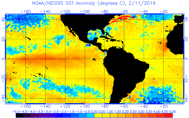
Hurricaneman wrote:The thing I noticed from the tropical tidbits site is that theyre SSTA map seems to have errors and doesnt match the NOAA site so I would take the Tropical Tidbits map as slighty erroneous

The posts in this forum are NOT official forecast and should not be used as such. They are just the opinion of the poster and may or may not be backed by sound meteorological data. They are NOT endorsed by any professional institution or storm2k.org. For official information, please refer to the NHC and NWS products


I totally agree with you, I always go by the NOAA site better, it smoothes out the ups and downs that could happen withing a week in SSTs.
I know there has been some cooking at the MDR during the past few weeks but with the models indicating the NAO going to at least neutral if not negative over the next couple of weeks I would expect a warm up once again.

Image
Last edited by NDG on Sun Apr 03, 2016 1:17 pm, edited 1 time in total.
0 likes   

User avatar
cycloneye
Admin
Admin
Posts: 145333
Age: 68
Joined: Thu Oct 10, 2002 10:54 am
Location: San Juan, Puerto Rico

Re: 2016 indicators: Instability / SST's / MSLP / Steering / Sal

#140 Postby cycloneye » Sun Apr 03, 2016 1:15 pm

Very interesting conversation between these experts with tweets from Levi Cowan,Michael Ventrice and Dr Eric Blake. To put it simple,the 2016 Atlantic season will be difficult to forecast due to many factors that may be in favor for an active season but other ones may come to damp that.

Levi Cowan ‏@TropicalTidbits · 6m6 minutes ago

@EricBlake12 @MJVentrice Starting to think Nino 1+2 will play a big role. If 1983-like, it's a non-season. If 1985-like, perhaps interesting


@EricBlake12

@TropicalTidbits @MJVentrice see 1998. Mega warm Nino1/2 irrelevant


Levi Cowan ‏@TropicalTidbits · 3m3 minutes ago

@EricBlake12 @MJVentrice Irrelevant to the MDR, perhaps. I also think importance of remote forcings change when +AMO disappears.


Eric Blake ‏@EricBlake12 · 1m1 minute ago

@TropicalTidbits @MJVentrice if true -AMO then balance changes to below/normal seasons. Big shift. PDO also looks like EPac not quiet


Michael Ventrice ‏@MJVentrice · 4s4 seconds ago

@EricBlake12 @TropicalTidbits I'm not convinced AMO goes -


Michael Ventrice ‏@MJVentrice · 3m3 minutes ago

@EricBlake12 @TropicalTidbits will be fun to watch!


‏@EricBlake12
@MJVentrice @TropicalTidbits cckws will be a lot more critical than last year I'd bet :)


‏@EricBlake12 · 4m4 minutes ago

@MJVentrice @TropicalTidbits not saying the areal-averaged one. This leading mode of active/inactive


Levi Cowan ‏@TropicalTidbits · 2m2 minutes ago

@EricBlake12 @MJVentrice Probably. What I'm hypothesizing has more to do with PDO projection on EPAC north of Nino 1+2.


Levi Cowan ‏@TropicalTidbits · 1m1 minute ago

@EricBlake12 @MJVentrice ...which would be bad news for this year. EPAC may win TC battle again.


Image
0 likes   
Visit the Caribbean-Central America Weather Thread where you can find at first post web cams,radars
and observations from Caribbean basin members Click Here


Return to “Talkin' Tropics”

Who is online

Users browsing this forum: riapal, Sciencerocks, Wampadawg and 56 guests