Low pressure in Central Atlantic (Is Invest 90L)

This is the general tropical discussion area. Anyone can take their shot at predicting a storms path.

Moderator: S2k Moderators

Forum rules

The posts in this forum are NOT official forecasts and should not be used as such. They are just the opinion of the poster and may or may not be backed by sound meteorological data. They are NOT endorsed by any professional institution or STORM2K. For official information, please refer to products from the National Hurricane Center and National Weather Service.

Help Support Storm2K
Message
Author
User avatar
cycloneye
Admin
Admin
Posts: 145336
Age: 68
Joined: Thu Oct 10, 2002 10:54 am
Location: San Juan, Puerto Rico

Low pressure in Central Atlantic (Is Invest 90L)

#1 Postby cycloneye » Mon Jan 04, 2016 1:18 pm

ECMWF is at it again near the Bahamas and then shoots NE with a hybrid type system.

72 hours.

Image

96 hours.

Image
0 likes   
Visit the Caribbean-Central America Weather Thread where you can find at first post web cams,radars
and observations from Caribbean basin members Click Here

User avatar
cycloneye
Admin
Admin
Posts: 145336
Age: 68
Joined: Thu Oct 10, 2002 10:54 am
Location: San Juan, Puerto Rico

Low pressure centered between the east coast and Bermuda

#2 Postby cycloneye » Tue Jan 05, 2016 4:05 pm

ECMWF keeps showing this hybrid type system. Something or nothing?

Image
0 likes   
Visit the Caribbean-Central America Weather Thread where you can find at first post web cams,radars
and observations from Caribbean basin members Click Here

xironman
S2K Supporter
S2K Supporter
Posts: 2522
Joined: Sun Jun 10, 2007 4:53 pm
Location: NoVA

Low pressure centered between the east coast and Bermuda

#3 Postby xironman » Wed Jan 06, 2016 11:37 am

Reverse Cape Verde?

Image
0 likes   

CrazyC83
Professional-Met
Professional-Met
Posts: 34002
Joined: Tue Mar 07, 2006 11:57 pm
Location: Deep South, for the first time!

Re: 2016 Global Model Runs Discussion

#4 Postby CrazyC83 » Wed Jan 06, 2016 9:26 pm

xironman wrote:Reverse Cape Verde?

Image


In January, that actually makes a lot more sense since the flow is west to east even in the mid-tropics. To go east to west would need a track near the equator and bumping into South America.
0 likes   

xironman
S2K Supporter
S2K Supporter
Posts: 2522
Joined: Sun Jun 10, 2007 4:53 pm
Location: NoVA

Low pressure centered between the east coast and Bermuda

#5 Postby xironman » Thu Jan 07, 2016 4:21 am

It certainly is unusual

Image
0 likes   

xironman
S2K Supporter
S2K Supporter
Posts: 2522
Joined: Sun Jun 10, 2007 4:53 pm
Location: NoVA

Low pressure centered between the east coast and Bermuda

#6 Postby xironman » Thu Jan 07, 2016 8:15 am

It is going to be a long trip to Portugal.

Image
0 likes   

User avatar
northjaxpro
S2K Supporter
S2K Supporter
Posts: 8900
Joined: Mon Sep 27, 2010 11:21 am
Location: Jacksonville, FL

Low pressure centered between the east coast and Bermuda

#7 Postby northjaxpro » Thu Jan 07, 2016 9:35 am

xironman wrote:It is going to be a long trip to Portugal.
http://i.imgur.com/xSRrn5D.jpg


Yeah, a long trip indeed. But, this Gale system looks good this morning and is deepening, now analyzed at 997 mb. It has dropped 13 mb in pressure since last night. Very large storm out there in the Atlantic. This Gale system really contributed in tightening the pressure gradient across my region yesterday. Strong High to the north/northeast and the Gale exiting the Bahamas bought about about the squeeze play from the northeast. Northeast wind gusted as high as 34 mph at my locale yesterday as that system was developing yesterday.
0 likes   
NEVER, EVER SAY NEVER in the tropics and weather in general, and most importantly, with life itself!!

________________________________________________________________________________________

Fay 2008 Beryl 2012 Debby 2012 Colin 2016 Hermine 2016 Julia 2016 Matthew 2016 Irma 2017 Dorian 2019

User avatar
SouthDadeFish
Professional-Met
Professional-Met
Posts: 2835
Joined: Thu Sep 23, 2010 2:54 pm
Location: Miami, FL
Contact:

Low pressure centered between the east coast and Bermuda

#8 Postby SouthDadeFish » Thu Jan 07, 2016 9:48 am

This is a pretty neat system. The models show the structure of this disturbance becoming more warm-core in nature over the next few days, but it is definitely being influenced by an upper tropospheric potential vorticity anomaly. Here's a 12-hour forecast from the 06Z GFS showing the tongue of higher PV extending towards the disturbance:

Image

Image

It might evolve into one of those compact-cored systems embedded in a larger synoptic scale disturbance. Subtropical development is certainly possible.
0 likes   

User avatar
northjaxpro
S2K Supporter
S2K Supporter
Posts: 8900
Joined: Mon Sep 27, 2010 11:21 am
Location: Jacksonville, FL

#9 Postby northjaxpro » Thu Jan 07, 2016 9:55 am

:uarrow: I would not be surprised SouthDade if it transitioned to that. This unique system really looks good and the visible imagery really shows that small, compact center quite well.
0 likes   
NEVER, EVER SAY NEVER in the tropics and weather in general, and most importantly, with life itself!!

________________________________________________________________________________________

Fay 2008 Beryl 2012 Debby 2012 Colin 2016 Hermine 2016 Julia 2016 Matthew 2016 Irma 2017 Dorian 2019

CrazyC83
Professional-Met
Professional-Met
Posts: 34002
Joined: Tue Mar 07, 2006 11:57 pm
Location: Deep South, for the first time!

Low pressure centered between the east coast and Bermuda

#10 Postby CrazyC83 » Thu Jan 07, 2016 2:47 pm

I decided to start a discussion folder on the Bahamas low. It would be crazy if we could get a storm out of it in January...but it happened in 1938, 1951 and 1978.
0 likes   

TheStormExpert

Re: Possible hybrid low near Bahamas

#11 Postby TheStormExpert » Thu Jan 07, 2016 2:57 pm

CrazyC83 wrote:I decided to start a discussion folder on the Bahamas low. It would be crazy if we could get a storm out of it in January...but it happened in 1938, 1951 and 1978.

Sounds like history could repeat itself again! :wink:
0 likes   

NotoSans
Category 5
Category 5
Posts: 1380
Age: 25
Joined: Sun Sep 27, 2015 1:15 am
Location: Toronto
Contact:

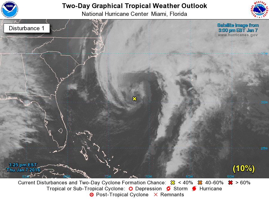
#12 Postby NotoSans » Thu Jan 07, 2016 3:35 pm

Image

1. An extratropical low pressure system centered about 425 miles west-
southwest of Bermuda is producing a large area of gale force winds
and maximum winds of 60 to 65 mph. Environmental conditions are not
expected to be conducive for subtropical or tropical cyclone
formation through the weekend while the low moves east-northeastward
into the central Atlantic Ocean. However, conditions could become
conducive for this system to acquire some subtropical
characteristics while it moves east-southeastward into the eastern
subtropical Atlantic Ocean by the middle of next week. The next
Special Tropical Weather Outlook on this system will be issued by
3 PM EST Friday. For additional information on this system, please
see High Seas Forecasts issued by the National Weather Service.
* Formation chance through 48 hours...low...10 percent
* Formation chance through 5 days...low...30 percent
0 likes   

xironman
S2K Supporter
S2K Supporter
Posts: 2522
Joined: Sun Jun 10, 2007 4:53 pm
Location: NoVA

Low pressure centered between the east coast and Bermuda

#13 Postby xironman » Thu Jan 07, 2016 5:24 pm

0 likes   

User avatar
gatorcane
S2K Supporter
S2K Supporter
Posts: 23691
Age: 47
Joined: Sun Mar 13, 2005 3:54 pm
Location: Boca Raton, FL

#14 Postby gatorcane » Thu Jan 07, 2016 5:51 pm

I am sure this Godzilla El Nino has something to do with this forming as well. Seems to have thrown weather patterns in this part of the world in a big loop. Looks rather good for sure on SAT imagery!
0 likes   

CrazyC83
Professional-Met
Professional-Met
Posts: 34002
Joined: Tue Mar 07, 2006 11:57 pm
Location: Deep South, for the first time!

#15 Postby CrazyC83 » Thu Jan 07, 2016 5:53 pm

It should be declared 90L soon at this rate...
0 likes   

User avatar
northjaxpro
S2K Supporter
S2K Supporter
Posts: 8900
Joined: Mon Sep 27, 2010 11:21 am
Location: Jacksonville, FL

Re:

#16 Postby northjaxpro » Thu Jan 07, 2016 6:15 pm

gatorcane wrote:I am sure this Godzilla El Nino has something to do with this forming as well. Seems to have thrown weather patterns in this part of the world in a big loop. Looks rather good for sure on SAT imagery!


Agreed!
0 likes   
NEVER, EVER SAY NEVER in the tropics and weather in general, and most importantly, with life itself!!

________________________________________________________________________________________

Fay 2008 Beryl 2012 Debby 2012 Colin 2016 Hermine 2016 Julia 2016 Matthew 2016 Irma 2017 Dorian 2019

User avatar
KatDaddy
Category 5
Category 5
Posts: 2815
Joined: Mon Oct 21, 2002 6:23 pm
Location: League City, Texas

Re: Possible hybrid low near Bahamas

#17 Postby KatDaddy » Thu Jan 07, 2016 6:28 pm

A friendly reminder that the 2016 Hurricane Season is on the way :wink:

Nothing like a SPECIAL TROPICAL WEATHER OUTLOOK in January. Hopefully this is not a sign of the upcoming hurricane but if El Nino goes neutral or a weak La Nina, it could be interesting.
0 likes   
The following post is NOT an official forecast and should not be used as such. It is just the opinion of the poster and may or may not be backed by sound meteorological data. It is NOT endorsed by any professional institution including storm2k.org For Official Information please refer to the NHC and NWS products.

User avatar
MGC
S2K Supporter
S2K Supporter
Posts: 5899
Joined: Sun Mar 23, 2003 9:05 pm
Location: Pass Christian MS, or what is left.

Re: Possible hybrid low near Bahamas

#18 Postby MGC » Thu Jan 07, 2016 6:41 pm

Code Yellow! What is the first name on 2016 list?....MGC
0 likes   

CrazyC83
Professional-Met
Professional-Met
Posts: 34002
Joined: Tue Mar 07, 2006 11:57 pm
Location: Deep South, for the first time!

Re: Possible hybrid low near Bahamas

#19 Postby CrazyC83 » Thu Jan 07, 2016 6:47 pm

MGC wrote:Code Yellow! What is the first name on 2016 list?....MGC


First name is Alex.
0 likes   

stormwise

#20 Postby stormwise » Thu Jan 07, 2016 9:34 pm

http://manati.star.nesdis.noaa.gov/rsca ... MBds19.png

Impressive cyclone , more so than the cpac TS.
0 likes   


Return to “Talkin' Tropics”

Who is online

Users browsing this forum: BobHarlem, Google Adsense [Bot] and 36 guests