Texas Winter 2015-2016

Winter Weather Discussion

Moderator: S2k Moderators

Forum rules

The posts in this forum are NOT official forecast and should not be used as such. They are just the opinion of the poster and may or may not be backed by sound meteorological data. They are NOT endorsed by any professional institution or STORM2K.

Help Support Storm2K
Message
Author
orangeblood
S2K Supporter
S2K Supporter
Posts: 3714
Joined: Tue Dec 15, 2009 6:14 pm
Location: Fort Worth, TX

Re:

#1681 Postby orangeblood » Mon Jan 04, 2016 11:28 am

Ntxw wrote:El Nino this week held steady at 2.7C. NINO 1+2 fell dramatically which means tropical forcing will center near the dateline. This is favorable for conus cold and roaring stj


Check out the MJO Forecast, complete opposite phases of what brought all the warmth in December. This pattern is ripe for cold to overwhelm!!

Image
0 likes   

User avatar
Ntxw
Storm2k Moderator
Storm2k Moderator
Posts: 22818
Joined: Wed Oct 21, 2009 6:34 pm
Location: DFW, Texas

#1682 Postby Ntxw » Mon Jan 04, 2016 11:39 am

Dont sleep on the storm of during the 10th +/-. GFS is quietly putting down a red river to Oklahoma snowstorm and potent front behind it. All over the place.
0 likes   
The above post and any post by Ntxw is NOT an official forecast and should not be used as such. It is just the opinion of the poster and may or may not be backed by sound meteorological data. It is NOT endorsed by any professional institution including Storm2k. For official information, please refer to NWS products.

  Help support Storm2K!
Help Support Storm2K

orangeblood
S2K Supporter
S2K Supporter
Posts: 3714
Joined: Tue Dec 15, 2009 6:14 pm
Location: Fort Worth, TX

Re:

#1683 Postby orangeblood » Mon Jan 04, 2016 11:56 am

Ntxw wrote:Dont sleep on the storm of during the 10th +/-. GFS is quietly putting down a red river to Oklahoma snowstorm and potent front behind it. All over the place.


Yeah, the Arctic Front depiction looks very suspicious on this run....stalls and backs it up before the LP moves along the boundary. How many times over the years have we seen these models correct south and sometimes, quite significantly!
0 likes   

User avatar
gatorcane
S2K Supporter
S2K Supporter
Posts: 23697
Age: 47
Joined: Sun Mar 13, 2005 3:54 pm
Location: Boca Raton, FL

#1684 Postby gatorcane » Mon Jan 04, 2016 11:59 am

Well the CMC is not backing off :cold: :eek:

Image
0 likes   

Ralph's Weather
S2K Supporter
S2K Supporter
Posts: 3273
Age: 38
Joined: Fri Dec 13, 2013 11:55 am
Location: Lindale, TX
Contact:

#1685 Postby Ralph's Weather » Mon Jan 04, 2016 12:23 pm

For the first time this year we are going to be rid of the SE ridge causing things to shoot off NE over TX so now eastern TX and the rest of the South can start to get in on the fun. There is sure some mighty cold air coming down next week.
0 likes   
Follow on Facebook at Ralph's Weather.

User avatar
TheProfessor
Professional-Met
Professional-Met
Posts: 3506
Age: 28
Joined: Tue Dec 03, 2013 10:56 am
Location: Wichita, Kansas

#1686 Postby TheProfessor » Mon Jan 04, 2016 12:28 pm

12z GFS has some snow showers for me in Ohio through out the run. Looks like the 12z CMC has a really good snow band just west of Columbus this weekend. :x
0 likes   
An alumnus of The Ohio State University.

Your local National Weather Service office is your best source for weather information.

orangeblood
S2K Supporter
S2K Supporter
Posts: 3714
Joined: Tue Dec 15, 2009 6:14 pm
Location: Fort Worth, TX

Re: Re:

#1687 Postby orangeblood » Mon Jan 04, 2016 12:36 pm

orangeblood wrote:
Ntxw wrote:Dont sleep on the storm of during the 10th +/-. GFS is quietly putting down a red river to Oklahoma snowstorm and potent front behind it. All over the place.


Yeah, the Arctic Front depiction looks very suspicious on this run....stalls and backs it up before the LP moves along the boundary. How many times over the years have we seen these models correct south and sometimes, quite significantly!


12Z Canadian has the storm further south - along I-20. GFS along I-40. Still see no reason to stray from the Canadian, has nailed this pattern change!
0 likes   

Ralph's Weather
S2K Supporter
S2K Supporter
Posts: 3273
Age: 38
Joined: Fri Dec 13, 2013 11:55 am
Location: Lindale, TX
Contact:

Re: Re:

#1688 Postby Ralph's Weather » Mon Jan 04, 2016 12:51 pm

orangeblood wrote:12Z Canadian has the storm further south - along I-20. GFS along I-40. Still see no reason to stray from the Canadian, has nailed this pattern change!

A blend of Canadian and Euro seems to be the best call this winter. GFS is is very unstable right now and has been that way for a while.
0 likes   
Follow on Facebook at Ralph's Weather.

User avatar
Portastorm
Storm2k Moderator
Storm2k Moderator
Posts: 9914
Age: 63
Joined: Fri Jul 11, 2003 9:16 am
Location: Round Rock, TX
Contact:

Re: Re:

#1689 Postby Portastorm » Mon Jan 04, 2016 1:08 pm

Ralph's Weather wrote:
orangeblood wrote:12Z Canadian has the storm further south - along I-20. GFS along I-40. Still see no reason to stray from the Canadian, has nailed this pattern change!

A blend of Canadian and Euro seems to be the best call this winter. GFS is is very unstable right now and has been that way for a while.


That seems like a reasonable course of action. I know some here are favorable to the CMC in saying that it has been consistent. Yes, consistency is important. But you can have medium range modeling that is consistently wrong. I would be reluctant to bank a forecast solely on the CMC.
0 likes   
Any forecasts under my name are to be taken with a grain of salt. Get your best forecasts from the National Weather Service and National Hurricane Center.

User avatar
Ntxw
Storm2k Moderator
Storm2k Moderator
Posts: 22818
Joined: Wed Oct 21, 2009 6:34 pm
Location: DFW, Texas

#1690 Postby Ntxw » Mon Jan 04, 2016 1:11 pm

Cmc beat the euro on the last blizzard on the track of the ULL and surface even going out to 24-48hrs. Euro was northern and western side vs verification.

Both the Euro and GFS have recently gone through upgrades so its hard to gage them
0 likes   
The above post and any post by Ntxw is NOT an official forecast and should not be used as such. It is just the opinion of the poster and may or may not be backed by sound meteorological data. It is NOT endorsed by any professional institution including Storm2k. For official information, please refer to NWS products.


  Help support Storm2K!

Help Support Storm2K


User avatar
TheProfessor
Professional-Met
Professional-Met
Posts: 3506
Age: 28
Joined: Tue Dec 03, 2013 10:56 am
Location: Wichita, Kansas

#1691 Postby TheProfessor » Mon Jan 04, 2016 1:12 pm

if the low were to be 50 miles southeast on the 12z CMC now only would I might see some snow here before I leave, but I would also see a decent snow storm in Central Ohio.
0 likes   
An alumnus of The Ohio State University.

Your local National Weather Service office is your best source for weather information.

Lagreeneyes03
Category 2
Category 2
Posts: 558
Joined: Mon Dec 09, 2013 10:53 am
Location: Luxurious Lake Grapevine

Re:

#1692 Postby Lagreeneyes03 » Mon Jan 04, 2016 1:41 pm

gboudx wrote:DFW made some mention of wintry precip this weekend as well.

THE WEEKEND SYSTEM HAS THE POTENTIAL TO BRING WINTRY WEATHER TO THE
REGION...BUT AT THIS TIME...IT LOOKS LIKE TEMPERATURES WILL NOT
BOTTOM OUT UNTIL AFTER THE RAINFALL HAS COME TO AN END.


Of course not. "Cold Rain". Always.
0 likes   
I'm a Princess, not a forecaster.

Yukon Cornelius
S2K Supporter
S2K Supporter
Posts: 1798
Age: 41
Joined: Thu Dec 20, 2012 9:23 pm
Location: Dean, TX/Westcliffe, CO

Re: Texas Winter 2015-2016

#1693 Postby Yukon Cornelius » Mon Jan 04, 2016 1:45 pm

What is the probability of severe cold entering north Texas and how cold are we actually talking about? Chances of winter precipitation? I know being a ways out its hard to tell exactly but owning a lot of livestock and especially calves, extreme cold could be very dangerous to the young ones. I'm wondering if I should go ahead and start planning or not.
0 likes   
#neversummer

Ralph's Weather
S2K Supporter
S2K Supporter
Posts: 3273
Age: 38
Joined: Fri Dec 13, 2013 11:55 am
Location: Lindale, TX
Contact:

Re: Texas Winter 2015-2016

#1694 Postby Ralph's Weather » Mon Jan 04, 2016 1:54 pm

Yukon Cornelius wrote:What is the probability of severe cold entering north Texas and how cold are we actually talking about? Chances of winter precipitation? I know being a ways out its hard to tell exactly but owning a lot of livestock and especially calves, extreme cold could be very dangerous to the young ones. I'm wondering if I should go ahead and start planning or not.

You are looking at potentially multiple nights in the teens and a couple shots of light snow. If you get snow cover then maybe single digits. Sub-freezing highs possible also. The likelihood of at least one hard freeze for you is very good. Moisture should be limited, but light snow is possible up there next week.
0 likes   
Follow on Facebook at Ralph's Weather.

User avatar
dhweather
S2K Supporter
S2K Supporter
Posts: 6199
Joined: Sat Aug 14, 2004 9:29 pm
Location: Heath, TX
Contact:

Re:

#1695 Postby dhweather » Mon Jan 04, 2016 3:06 pm

gatorcane wrote:Well the CMC is not backing off :cold: :eek:

http://i.imgur.com/y0zIenN.png


CMC often is really right or really wrong, no in between. It was on the money for the Feb/Mar 2015 wintry weather. And bless its heart, in the summertime it spins up a lot of CAT 5's IN THE GULF!!! :cheesy:
0 likes   
The above post and any post by dhweather is NOT an official forecast and should not be used as such. It is just the opinion of the poster and may or may not be backed by sound meteorological data. It is NOT endorsed by any professional institution including storm2k.org. For official information, please refer to NWS products.

Yukon Cornelius
S2K Supporter
S2K Supporter
Posts: 1798
Age: 41
Joined: Thu Dec 20, 2012 9:23 pm
Location: Dean, TX/Westcliffe, CO

Re: Texas Winter 2015-2016

#1696 Postby Yukon Cornelius » Mon Jan 04, 2016 3:19 pm

Ralph's Weather wrote:
Yukon Cornelius wrote:What is the probability of severe cold entering north Texas and how cold are we actually talking about? Chances of winter precipitation? I know being a ways out its hard to tell exactly but owning a lot of livestock and especially calves, extreme cold could be very dangerous to the young ones. I'm wondering if I should go ahead and start planning or not.

You are looking at potentially multiple nights in the teens and a couple shots of light snow. If you get snow cover then maybe single digits. Sub-freezing highs possible also. The likelihood of at least one hard freeze for you is very good. Moisture should be limited, but light snow is possible up there next week.

Thanks man, I appreciate it. Looks like I've got my work cut out for me for a few days.
0 likes   
#neversummer

User avatar
Rgv20
S2K Supporter
S2K Supporter
Posts: 2466
Age: 39
Joined: Wed Jan 05, 2011 5:42 pm
Location: Edinburg/McAllen Tx

#1697 Postby Rgv20 » Mon Jan 04, 2016 3:23 pm

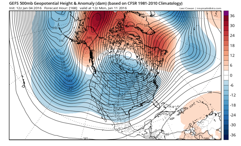
12zGFS Ensemble 500mb Ensemble Mean forecast for Day 7.........Winter is Coming! :cold:

Image

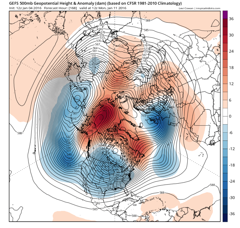
Northern Hemisphere View...Could it tap into Siberian Air?? :P

Image
0 likes   
The following post is NOT an official forecast and should not be used as such. It is just the opinion of the poster and may or may not be backed by sound meteorological data. It is NOT endorsed by any professional institution including storm2k.org For Official Information please refer to the NHC and NWS products.

User avatar
TeamPlayersBlue
Category 5
Category 5
Posts: 3446
Joined: Tue Feb 02, 2010 1:44 am
Location: Denver/Applewood, CO

#1698 Postby TeamPlayersBlue » Mon Jan 04, 2016 4:22 pm

So close according to the models from there being a winter storm in Texas. At the moment i like the Euro most, CMC, then GFS. The pattern looks beautiful on all of them though for next week.

One thing i did last night was look at analogs that are popping up over the 6-10 day period. One of them was an analog for a sizeable ice storm we had here in houston in '97.

A lot of football left winter lovers!
0 likes   
Personal Forecast Disclaimer:
The posts in this forum are NOT official forecast and should not be used as such. They are just the opinion of the poster and may or may not be backed by sound meteorological data. They are NOT endorsed by any professional institution or storm2k.org. For official information, please refer to the NHC and NWS products.
User avatar
hriverajr
Professional-Met
Professional-Met
Posts: 786
Joined: Tue Jul 19, 2005 12:16 am

Re: Texas Winter 2015-2016

#1699 Postby hriverajr » Mon Jan 04, 2016 4:22 pm

"LONGER RANGE MODELS STILL SHOW AN ARCTIC AIR OUTBREAK FOR
LOCATIONS EAST OF THE ROCKIES AFTER JANUARY 12TH. THE CENTER OF
THE COLD AIR SEEMS HEADED TOWARD THE OHIO RIVER VALLEY...BUT WE
COULD STILL BE ON THE FRINGE OF THE AIR MASS AND HAVE MUCH COLDER
THAN NORMAL TEMPERATURES."

EWX seems to be looking at the 6z GFS....
0 likes   
Anything I post is my personal opinion and should not used for any type of planning or lifesaving reasons. Please refer to National Weather Service forecasts.

User avatar
cctxhurricanewatcher
Category 5
Category 5
Posts: 1206
Joined: Sun Sep 12, 2004 8:53 pm
Location: Corpus Christi, Texas

#1700 Postby cctxhurricanewatcher » Mon Jan 04, 2016 4:25 pm

Gotta love the last paragraph from the NWS Lub...


OUR NEXT TOPIC OF INTEREST IS EARLY SATURDAY MORNING. A COLD FRONT
MOVES IN ALONG WITH ANOTHER WAVE...THIS ONE APPEARS TO BE A TAD
STRONGER THAN WEDNESDAY/S. OVERNIGHT LOWS ACROSS MUCH OF THE
PANHANDLE AND SOUTH PLAINS WILL FALL TO OR BELOW FREEZING SO
EXPECTING TO SEE MIXED PHASE PRECIP WITH A RETURN TO ALL LIQUID
DURING THE DAY. STILL A WAYS OUT...SO TIMING IS AN ISSUE ON THE
ARRIVAL BOTH THE WAVE AND THE COLD AIR AND THE DEPTH OF THAT COLD
AIR. THAT LEADS US INTO THE FINAL TIDBIT...NEXT WEEK. MODELS ARE
HINTING AT AN ARCTIC BLAST...GFS WANTS TO MAKE IT COLD...EURO WANTS
TO PUT US IN THE FREEZER BEHIND THE ICE CREAM! WE WILL BE WATCHING
CLOSELY TO SEE HOW THE MODELS TREND OVER THE NEXT SEVERAL DAYS...BUT
DON/T PUT THE MITTENS AWAY.
0 likes   


Return to “Winter Weather”

Who is online

Users browsing this forum: No registered users and 75 guests