Texas Fall-2015

U.S. & Caribbean Weather Discussions and Severe Weather Events

Moderator: S2k Moderators

Forum rules

The posts in this forum are NOT official forecast and should not be used as such. They are just the opinion of the poster and may or may not be backed by sound meteorological data. They are NOT endorsed by any professional institution or STORM2K.

Help Support Storm2K
Message
Author
Ralph's Weather
S2K Supporter
S2K Supporter
Posts: 3269
Age: 38
Joined: Fri Dec 13, 2013 11:55 am
Location: Lindale, TX
Contact:

Re:

#2081 Postby Ralph's Weather » Thu Nov 19, 2015 9:42 am

1900hurricane wrote:Most of the talk has been about the cold air following the system around Thanksgiving, but the actual system itself looks like it could bring another heavy rain event accompanied by perhaps some severe weather. Models are once again hitting at low level trajectories off the Caribbean and with upper level moisture streaming in from an Eastern Pacific tropical cyclone (which would be extremely late season at this point) carried by strong SW flow aloft. If we get a slow moving surface boundary in the right place, the floodgates will likely open up above someone.

For impacts on Texas it appears to be a similar situation to Patricia with a storm hitting Mexico and the STJ transporting its moisture into Texas. Looks like it will generate a surface low off of the coast while the Arctic high bleeds down the Plains.
0 likes   
Follow on Facebook at Ralph's Weather.

User avatar
Portastorm
Storm2k Moderator
Storm2k Moderator
Posts: 9914
Age: 63
Joined: Fri Jul 11, 2003 9:16 am
Location: Round Rock, TX
Contact:

Re:

#2082 Postby Portastorm » Thu Nov 19, 2015 9:44 am

Ralph's Weather wrote:0Z sure does look very classic -EPO and I agree that the STJ would likely produce more precip than shown.
06Z looks +PNA with the trough sliding east. Followed by a system with no cold air left. I will discount this run as it is so different from previous runs.


In that case, how do both runs compare to the 0z ensemble mean? I haven't looked but that seems to be the safest bet.
0 likes   
Any forecasts under my name are to be taken with a grain of salt. Get your best forecasts from the National Weather Service and National Hurricane Center.

Ralph's Weather
S2K Supporter
S2K Supporter
Posts: 3269
Age: 38
Joined: Fri Dec 13, 2013 11:55 am
Location: Lindale, TX
Contact:

Re: Re:

#2083 Postby Ralph's Weather » Thu Nov 19, 2015 9:55 am

Portastorm wrote:
Ralph's Weather wrote:0Z sure does look very classic -EPO and I agree that the STJ would likely produce more precip than shown.
06Z looks +PNA with the trough sliding east. Followed by a system with no cold air left. I will discount this run as it is so different from previous runs.


In that case, how do both runs compare to the 0z ensemble mean? I haven't looked but that seems to be the safest bet.

0Z GFS ensemble was much like the 0Z op and previous runs with a pretty classic -EPO. 06Z has a much less -EPO (-200 for next week then -100 vs previous runs which were in the -300 territory and held there) than previous runs which leads to a much less amplified pattern.
0 likes   
Follow on Facebook at Ralph's Weather.

User avatar
Ntxw
Storm2k Moderator
Storm2k Moderator
Posts: 22784
Joined: Wed Oct 21, 2009 6:34 pm
Location: DFW, Texas

#2084 Postby Ntxw » Thu Nov 19, 2015 10:02 am

:uarrow: Relative to normal though the guidance (including ensembles) drills the coldest anomalies into the Great Plains down to Texas. The strength and location of the upper ridge (western coast of Canada vs Alaska and anywhere in between) could spell either strong cold snap vs severe Arctic outbreak. The means won't give much of an answer at this time. One thing though, it's been trending away from sending it down the far west and more towards the high Rockies and Plains.

http://www.tropicaltidbits.com/analysis/models/?model=gfs-ens&region=namer&pkg=T2ma&runtime=2015111906&fh=6&xpos=0&ypos=551

The same case for the current cold front coming down, lee side of the rockies vs the west.
0 likes   
The above post and any post by Ntxw is NOT an official forecast and should not be used as such. It is just the opinion of the poster and may or may not be backed by sound meteorological data. It is NOT endorsed by any professional institution including Storm2k. For official information, please refer to NWS products.

  Help support Storm2K!
Help Support Storm2K

gpsnowman
S2K Supporter
S2K Supporter
Posts: 3185
Joined: Fri Jan 07, 2011 10:35 am
Location: Grand Prairie Tx

#2085 Postby gpsnowman » Thu Nov 19, 2015 11:00 am

I really hope the first freeze or heavy frost happens Sunday morning. The mosquitos in my backyard are still quite numerous. Ugggghhhh, go away already. :cold:
0 likes   

User avatar
Portastorm
Storm2k Moderator
Storm2k Moderator
Posts: 9914
Age: 63
Joined: Fri Jul 11, 2003 9:16 am
Location: Round Rock, TX
Contact:

Re: Texas Fall-2015

#2086 Postby Portastorm » Thu Nov 19, 2015 11:00 am

I think what both the 0z and 6z means show us is that the signal is there for a dump of cold air into our part of the country. Granted the 6z means are weaker in terms of impact but the overall pattern is there. Will be interesting to see how it shapes up/out. Between that and the recurving E-Pac system we have an awful lot of weather to talk about over the next few weeks!
0 likes   
Any forecasts under my name are to be taken with a grain of salt. Get your best forecasts from the National Weather Service and National Hurricane Center.

Ralph's Weather
S2K Supporter
S2K Supporter
Posts: 3269
Age: 38
Joined: Fri Dec 13, 2013 11:55 am
Location: Lindale, TX
Contact:

Re:

#2087 Postby Ralph's Weather » Thu Nov 19, 2015 11:07 am

Ntxw wrote::uarrow: Relative to normal though the guidance (including ensembles) drills the coldest anomalies into the Great Plains down to Texas. The strength and location of the upper ridge (western coast of Canada vs Alaska and anywhere in between) could spell either strong cold snap vs severe Arctic outbreak. The means won't give much of an answer at this time. One thing though, it's been trending away from sending it down the far west and more towards the high Rockies and Plains.

The same case for the current cold front coming down, lee side of the rockies vs the west.

That makes sense, I guess ideally the Arctic air mass would flow down the lee of the Rockies. In any case we still have 20+ runs of the models before it really becomes clear how things will play out.
0 likes   
Follow on Facebook at Ralph's Weather.

Ralph's Weather
S2K Supporter
S2K Supporter
Posts: 3269
Age: 38
Joined: Fri Dec 13, 2013 11:55 am
Location: Lindale, TX
Contact:

#2088 Postby Ralph's Weather » Thu Nov 19, 2015 11:46 am

12Z GFS is starting to look very interesting with a stronger Plain trough that is slower to move out with a second Arctic high set to come down, plus the E Pac system and now a CA system.

The beginning of December looks unsettled and still cold on this run.
0 likes   
Follow on Facebook at Ralph's Weather.

User avatar
srainhoutx
S2K Supporter
S2K Supporter
Posts: 6919
Age: 67
Joined: Sun Jan 14, 2007 11:34 am
Location: Haywood County, NC
Contact:

Re: Texas Fall-2015

#2089 Postby srainhoutx » Thu Nov 19, 2015 12:06 pm

The 12Z GFS suggests a very cold Arctic High settling into the Plains on Saturday/Sunday as we end the busy Thanksgiving Holiday travel period. The GFS also suggests a land falling Eastern Pacific tropical cyclone along the West Coast of Mexico as the cold air is entrenched across the Lone Star State. There are also indications of a Coastal trough/low organizing near Brownsville. While this is still a ways out, the teleconnection indices continue to advertise a very -EPO and a + PNA regime which tends to build a Ridge into Alaska allowing a chunk of very cold air to drop South from Siberia into Western Canada and into the Plains.

Image

Image
0 likes   
Carla/Alicia/Jerry(In The Eye)/Michelle/Charley/Ivan/Dennis/Katrina/Rita/Wilma/Ike/Harvey

Member: National Weather Association
Wx Infinity Forums
http://wxinfinity.com/index.php

Facebook.com/WeatherInfinity
Twitter @WeatherInfinity

User avatar
TheProfessor
Professional-Met
Professional-Met
Posts: 3506
Age: 28
Joined: Tue Dec 03, 2013 10:56 am
Location: Wichita, Kansas

#2090 Postby TheProfessor » Thu Nov 19, 2015 12:18 pm

I like how the low this weekend decides to take a sharp Northeast turn as it reaches Ohio's Borders. :cry:
0 likes   
An alumnus of The Ohio State University.

Your local National Weather Service office is your best source for weather information.

User avatar
Ntxw
Storm2k Moderator
Storm2k Moderator
Posts: 22784
Joined: Wed Oct 21, 2009 6:34 pm
Location: DFW, Texas

#2091 Postby Ntxw » Thu Nov 19, 2015 1:49 pm

TS Rick got named today along the west coast of Mexico (90E). Don't think this is the big TG hurricane modeled (next one behind it) but the EPAC going into overtime. His moisture should bring some rain early next week especially souther tier of the state.
0 likes   
The above post and any post by Ntxw is NOT an official forecast and should not be used as such. It is just the opinion of the poster and may or may not be backed by sound meteorological data. It is NOT endorsed by any professional institution including Storm2k. For official information, please refer to NWS products.


  Help support Storm2K!

Help Support Storm2K


User avatar
srainhoutx
S2K Supporter
S2K Supporter
Posts: 6919
Age: 67
Joined: Sun Jan 14, 2007 11:34 am
Location: Haywood County, NC
Contact:

Re: Texas Fall-2015

#2092 Postby srainhoutx » Thu Nov 19, 2015 2:04 pm

The 12Z Euro suggests a deep Western trough and Arctic cold front arriving across the Panhandle a week from Saturday as a land falling tropical cyclone strikes the West Coast of Mexico. The Arctic boundary pushes South on Sunday with a very unsettled SW flow aloft and associated tropical moisture in the mid/upper levels arriving across Texas Saturday night into Sunday the 29th.
0 likes   
Carla/Alicia/Jerry(In The Eye)/Michelle/Charley/Ivan/Dennis/Katrina/Rita/Wilma/Ike/Harvey

Member: National Weather Association
Wx Infinity Forums
http://wxinfinity.com/index.php

Facebook.com/WeatherInfinity
Twitter @WeatherInfinity

texas1836
Tropical Storm
Tropical Storm
Posts: 223
Age: 55
Joined: Fri Aug 17, 2012 10:10 am
Location: Ruidoso, New Mexico

#2093 Postby texas1836 » Thu Nov 19, 2015 2:26 pm

:uarrow: Think it could bring freezing precip to North Texas? Is the air mass that cold?
0 likes   

User avatar
TheProfessor
Professional-Met
Professional-Met
Posts: 3506
Age: 28
Joined: Tue Dec 03, 2013 10:56 am
Location: Wichita, Kansas

Re: Texas Fall-2015

#2094 Postby TheProfessor » Thu Nov 19, 2015 2:26 pm

srainhoutx wrote:The 12Z Euro suggests a deep Western trough and Arctic cold front arriving across the Panhandle a week from Saturday as a land falling tropical cyclone strikes the West Coast of Mexico. The Arctic boundary pushes South on Sunday with a very unsettled SW flow aloft and associated tropical moisture in the mid/upper levels arriving across Texas Saturday night into Sunday the 29th.


I'm all for wintery Weather, but I need to fly back to school next Sunday so I don't want it to happen, on that day at least.
0 likes   
An alumnus of The Ohio State University.

Your local National Weather Service office is your best source for weather information.

User avatar
TheProfessor
Professional-Met
Professional-Met
Posts: 3506
Age: 28
Joined: Tue Dec 03, 2013 10:56 am
Location: Wichita, Kansas

Re:

#2095 Postby TheProfessor » Thu Nov 19, 2015 2:30 pm

texas1836 wrote::uarrow: Think it could bring freezing precip to North Texas? Is the air mass that cold?


It depends on how cold the air is and where the cold air is, we've seen storms dump tons of snow with surface temps above freezing while the upper levels are very cold a la 2010, and we've seen storms end up as rain when the Surface temps are right around 32 degrees due to there being a large warm nose a la the rain event that occured in between the ice event and the snow event last winter. It's way to early to tell.
0 likes   
An alumnus of The Ohio State University.

Your local National Weather Service office is your best source for weather information.

User avatar
gboudx
S2K Supporter
S2K Supporter
Posts: 4080
Joined: Thu Sep 04, 2003 1:39 pm
Location: Rockwall, Tx but from Harvey, La

Re: Texas Fall-2015

#2096 Postby gboudx » Thu Nov 19, 2015 2:57 pm

TheProfessor wrote:
srainhoutx wrote:The 12Z Euro suggests a deep Western trough and Arctic cold front arriving across the Panhandle a week from Saturday as a land falling tropical cyclone strikes the West Coast of Mexico. The Arctic boundary pushes South on Sunday with a very unsettled SW flow aloft and associated tropical moisture in the mid/upper levels arriving across Texas Saturday night into Sunday the 29th.


I'm all for wintery Weather, but I need to fly back to school next Sunday so I don't want it to happen, on that day at least.


If it's freezing rain and ice, I never want that. If it's snow, then thousands of school kids will more than trump you're flight back to tOSU. :)
0 likes   

User avatar
TeamPlayersBlue
Category 5
Category 5
Posts: 3445
Joined: Tue Feb 02, 2010 1:44 am
Location: Denver/Applewood, CO

#2097 Postby TeamPlayersBlue » Thu Nov 19, 2015 3:00 pm

Weekend after Turkey looks interesting. A high coming down that strong will have freezing temps to the coast. Not sure why GFS cant see that lol
0 likes   
Personal Forecast Disclaimer:
The posts in this forum are NOT official forecast and should not be used as such. They are just the opinion of the poster and may or may not be backed by sound meteorological data. They are NOT endorsed by any professional institution or storm2k.org. For official information, please refer to the NHC and NWS products.

User avatar
TheProfessor
Professional-Met
Professional-Met
Posts: 3506
Age: 28
Joined: Tue Dec 03, 2013 10:56 am
Location: Wichita, Kansas

Re: Texas Fall-2015

#2098 Postby TheProfessor » Thu Nov 19, 2015 3:23 pm

gboudx wrote:
TheProfessor wrote:
srainhoutx wrote:The 12Z Euro suggests a deep Western trough and Arctic cold front arriving across the Panhandle a week from Saturday as a land falling tropical cyclone strikes the West Coast of Mexico. The Arctic boundary pushes South on Sunday with a very unsettled SW flow aloft and associated tropical moisture in the mid/upper levels arriving across Texas Saturday night into Sunday the 29th.


I'm all for wintery Weather, but I need to fly back to school next Sunday so I don't want it to happen, on that day at least.


If it's freezing rain and ice, I never want that. If it's snow, then thousands of school kids will more than trump you're flight back to tOSU. :)


They can wait one more day, I got finals coming up.
0 likes   
An alumnus of The Ohio State University.

Your local National Weather Service office is your best source for weather information.

Ralph's Weather
S2K Supporter
S2K Supporter
Posts: 3269
Age: 38
Joined: Fri Dec 13, 2013 11:55 am
Location: Lindale, TX
Contact:

Re:

#2099 Postby Ralph's Weather » Thu Nov 19, 2015 3:26 pm

TeamPlayersBlue wrote:Weekend after Turkey looks interesting. A high coming down that strong will have freezing temps to the coast. Not sure why GFS cant see that lol

100% agreed, but it happens every time. The front comes faster and with colder air than modeled. 20s are all but guaranteed for most of the north half of the state unless the STJ completely takes over and we end up with 30-34 for days even then temps tend to fall into the 20s sometimes.
0 likes   
Follow on Facebook at Ralph's Weather.

weatherdude1108
Category 5
Category 5
Posts: 4228
Joined: Tue Dec 13, 2011 1:04 pm
Location: Northwest Austin/Cedar Park, TX

#2100 Postby weatherdude1108 » Thu Nov 19, 2015 4:43 pm

EWX mentions how "Thanksgiving could be annoyingly wet..." around here.

I, personally am never annoyed by the wet, even if I have to travel in it.
:P Bring it!
:rain: :lightning: :rain: :rain:

Looks a tad chilly and windy Saturday! Flirting with a freeze in the Austin metro.
:cold: :flag: :flag: :cold:

We are climatologically overdue for a freeze, so shouldn't be a shocker. It is when you're used to the 70s and chamber o' commerce conditions.
:sun: :cheesy:


FXUS64 KEWX 192103
AFDEWX

AREA FORECAST DISCUSSION
NATIONAL WEATHER SERVICE AUSTIN/SAN ANTONIO TX
303 PM CST THU NOV 19 2015

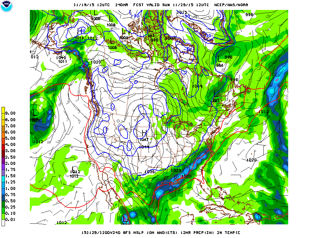
.LONG TERM (SATURDAY THROUGH THURSDAY)...
THE FOCUS OF THE LONG TERM WAS ON THE STRONG COLD FRONT PROGGED TO
BEGIN ENTERING THE CWA SATURDAY MORNING
. MODELS HAVE THE FRONT
KNOCKIN' ON THE DOOR OF THE NORTHERN CWA BORDER BY 12Z. WOULD
EXPECT SIGNIFICANT CLOUD COVER SOUTH OF THE FRONT IN THE MORNING
BUT RAPIDLY CLEAR OUT AS IT MOVES THROUGH. BETTER MOISTURE IN THE
SOUTHEAST ZONES WILL HAVE THE BEST CHANCE FOR SHOWER ACTIVITY WITH
THE FRONTAL PASSAGE...AND CHC POPS HAVE BEEN CONTINUED IN THOSE
LOCATIONS. HOWEVER...THE MOST NOTEWORTHY ASPECTS OF THE FRONTAL
PASSAGE WILL BE THE SIGNIFICANT COOLER TEMPERATURES AND STRONG PGF
THAT WILL RESULT IN QUITE A WINDY DAY SATURDAY.


DETERMINISTIC GFS WAS DEPICTING A 7 MB PRESSURE GRADIENT FROM THE
NORTH TO THE SOUTH OF THE CWA WITH SUSTAINED 30+ KT NORTH WINDS.

WHILE THERE IS SOME DISAGREEMENT IN EXACTLY HOW WINDY IT WILL GET
IN MOS GUIDANCE...WITH SIMILAR PRESSURE GRADIENTS DEPICTED IN THE
NAM/GFS/EURO...FEEL A MORE LIBERAL FORECAST FOR WINDS IS
WARRANTED. WITH THIS AIR MASS PROGGED TO BE SO MUCH COLDER...WOULD
MAKE SENSE FOR THIS MUCH DENSER AIR TO TRAVEL AT A DECENT CLIP
ACROSS THE AREA. AS A RESULT...INDICATED SUSTAINED WINDS OF 20-30
MPH WITH GUST POTENTIAL TO 40-45 FOR NOW. IF MODELS CONTINUE TO
SHOW THIS PGF...A WIND ADVISORY WOULD BE CERTAINLY WARRANTED.


ALSO...OUR FIRST FREEZE LOOKS LIKELY FOR AT LEAST THE NORTHERN
ZONES AND PLATEAU COUNTIES SUNDAY AND MONDAY MORNINGS. SIGNIFICANT
DIFFERENCES EXIST IN MAGNITUDE OF THE LOW TEMPS...BUT NAM/EURO ARE
ADVERTISING UPPER 20S AND LOWER 30S WHEREAS THE STANDOUT GFS IS
TRYING TO ADVERTISE LOW TO MID 20S. PREFERRED THE WARMER OUTCOMES
NOW BUT DID UNDERCUT THE NAM/EURO BY A DEGREE OR TWO...OUT OF
RESPECT.


MOVING INTO THE EXTENDED...OUR NEXT DEEP UPPER LOW WILL BEGIN TO
TAKE SHAPE OVER THE PACIFIC NORTHWEST AND ROCKIES BY WEDNESDAY
RESULTING IN AN UPTICK IN POPS BY WEDNESDAY NIGHT THROUGH FRIDAY.
AT THIS TIME...ONLY LIGHT QPF VALUES ARE EXPECTED AS INSTABILITY
SHOULD BE VERY MINIMAL AND DYNAMICS ARENT NEARLY AS IMPRESSIVE
WITH THIS LOW COMPARED TO OUR PREVIOUS STORM SYSTEM. BUT FOR
NOW...IT DOES LOOK LIKE THANKSGIVING COULD BE ANNOYINGLY WET FOR
SOUTH CENTRAL TEXAS...BUT NOT NECESSARILY A WASHOUT.
MORE DETAILS
ON THIS WITH LATER FORECAST PACKAGES.
0 likes   
The preceding post is NOT an official forecast, and should not be used as such. It is only the opinion of the poster and may or may not be backed by sound meteorological data. It is NOT endorsed by any professional institution including storm2k.org. For Official Information please refer to the NHC and NWS products.


Return to “USA & Caribbean Weather”

Who is online

Users browsing this forum: AnnularCane, Cpv17 and 11 guests