Looks like Corsicana is going to be the bullseye for this event. Dumping there now with lots more to go.
Just looked at the HRRR and it looks like the rain will continue for you dallas folks for at least the next 15 hrs.
Houston area, it looked like around noon is when the rain begins.
Texas Fall-2015
Moderator: S2k Moderators
Forum rules

The posts in this forum are NOT official forecast and should not be used as such. They are just the opinion of the poster and may or may not be backed by sound meteorological data. They are NOT endorsed by any professional institution or STORM2K.
-
TeamPlayersBlue

- Category 5

- Posts: 3531
- Joined: Tue Feb 02, 2010 1:44 am
- Location: Denver/Applewood, CO
0 likes
Personal Forecast Disclaimer:
The posts in this forum are NOT official forecast and should not be used as such. They are just the opinion of the poster and may or may not be backed by sound meteorological data. They are NOT endorsed by any professional institution or storm2k.org. For official information, please refer to the NHC and NWS products.
The posts in this forum are NOT official forecast and should not be used as such. They are just the opinion of the poster and may or may not be backed by sound meteorological data. They are NOT endorsed by any professional institution or storm2k.org. For official information, please refer to the NHC and NWS products.
-
srainhoutx

- S2K Supporter

- Posts: 6919
- Age: 68
- Joined: Sun Jan 14, 2007 11:34 am
- Location: Haywood County, NC
- Contact:
Re: Texas Fall-2015
The 00Z Global and Mesoscale guidance continues to suggest a worrisome forecast across Central, SE, East Texas and Western/SW Louisiana will unfold later today into Monday. Patricia, although well inland continues to produce winds near 100 MPH with higher gusts as it moves ENE over the mountains of Central Mexico. A cold front is slowly advancing SE over NW/N Central Texas with a stationary boundary across Central Texas extending to near Shreveport where heavy training rainfall has been occurring. Rainfall rates nearing 3 inches per hour is leading to life threatening Flash Flooding where training storms exist. Virtually all of the guidance develop a coastal low later this evening across S Texas as the mid/upper level vorticity associated with Patricia approaches S Central Texas. The combination of Patricia remnants, a slow moving frontal boundary and a surface low reflection near the Texas Gulf Coast that takes about 24 to 36 hours to move just S of Lake Charles is a recipe for a very heavy multi hour rainfall event with convective elements. Rainfall rates of 3+ inches per hour is possible anywhere across the Austin to College Station, Houston, Beaumont, Lufkin and Lake Charles area on N and E. Not going to pinpoint who will get the heaviest rainfall, but locations along and S of the I-35 Corridor could see rainfall totals nearing 12+ inches the next 36 to 48 hours.
...HIGH RISK OF EXCESSIVE RAINFALL OVER CENTRAL AND SOUTHEAST
TEXAS...
DEEP TROPICAL MOISTURE WAS ALREADY IN PLACE OVER A BROAD SWATH OF
THE SOUTHERN PLAINS. VERY HEAVY RAINFALL ON THU/FRI HAD FOCUSED
ALONG A STALLED FRONTAL ZONE AND IN THE ENTRANCE REGION OF A
STRONG UPPER JET...DUMPING 8 TO 13 INCHES OF RAIN ALREADY IN PARTS
OF CENTRAL AND NORTHEAST TEXAS. THIS MULTIPLE DAY EVENT WILL
EVOLVE SIGNIFICANTLY DURING THE DAY AND EVENING ON SATURDAY...AS
THE COMBINATION OF A MID LEVEL SHORTWAVE ASSOCIATED WITH HURRICANE
PATRICIA AND A SOUTHERN STREAM BAROCLINIC TROUGH PROGRESSING OUT
OF NEW MEXICO ACT TO INDUCE BROAD CYCLOGENESIS IN SOUTH TEXAS. THE
2.50 INCH PRECIPITABLE WATER MEASURED IN THE 00Z BROWNSVILLE TX
SOUNDING WAS WELL INTO RECORD TERRITORY FOR THE DATE...ALTHOUGH
SIMILAR VALUES HAD BEEN MEASURED AS LATE AS OCTOBER 16TH WITHIN
THE PERIOD OF RECORD. THE MOISTURE QUALITY IS OF GREAT
CONCERN...AS DEEP LAYER ASCENT WILL BE FORMIDABLE AND SUSTAINED
OVER A LENGTHY DURATION AS THE LARGER SCALE CYCLONE TAKES SHAPE.
FALLING HEIGHTS WILL ENHANCE INFLOW OFF THE GULF...AND YIELD
NORTHWARD MOVING CELLS TO MERGE WITH LARGER SCALE THUNDERSTORM
SYSTEMS OCCURRING IN THE HILL COUNTRY AND NEAR THE COAST...WITH
ONLY SLOW NET MOVEMENT TOWARD THE EAST.
THE MODELS ARE UNANIMOUS IN DEPICTING EXTREMELY HEAVY RAIN OVER
THE 24-HOUR PERIOD THROUGH SUNDAY MORNING...AND THE LOCATIONS OF
MAXIMUM AMOUNTS FROM THE VARIOUS MODELS ARE RELATIVELY WELL
CLUSTERED WITHIN THE HIGH RISK AREA...FROM THE VICINITY OF AUSTIN
AND THE EASTERN SIDE OF SAN ANTONIO TO VICTORIA TO HOUSTON.
MODERATE RISK SURROUNDS THE HIGH RISK AREA...AND EXTENDS INTO FAR
SOUTHWEST LOUISIANA. THE WRF-ARW AND GFS WERE MORE AGGRESSIVE IN
TIMING THE PROGRESSION OF HEAVIER RAIN INTO LA...BUT THE WPC
FORECAST HOLDS BACK A BIT...EXPECTING THAT COLD POOLS WILL BE VERY
WEAK IN THIS TROPICAL ENVIRONMENT UNTIL LATER ON SATURDAY NIGHT
INTO SUNDAY WHEN THE SYSTEM TAKES ON STRONGER BAROCLINIC CHARACTER
AND PROGRESSES FARTHER EAST.
THE HIGH FLASH FLOOD GUIDANCE VALUES SEEN OVER PARTS OF SOUTHEAST
TX WERE NOT GIVEN ANY WEIGHT IN THE FORECAST AS THE LAND IS LIKELY
TO BE OVERWHELMED BY INTENSE RAIN RATES AND AREAL AVERAGE
PRECIPITATION WHICH IS FORECAST TO EXCEED 10 INCHES NEAR THE
COAST. RAIN RATES IN THE WRF-ARW JUST START TO TOUCH UPON 3 INCHES
PER HOUR...AND GIVEN THE SITUATION IS SO FAVORABLE FOR EFFICIENT
RAINFALL...THE ATMOSPHERE MAY BE CAPABLE OF SUSTAINING 4 INCH PER
HOUR RATES TODAY...RESULTING IN THE RAPID ONSET OF FLASH FLOODING.
THANKS TO WFO HGX...CRP...EWX...AND FWD FOR COORDINATION ON THE
HIGH RISK ISSUANCE
A quick look at the next weekend forecast suggests another potential heavy rainfall event is possible as yet another deep Western trough develops and moisture from the Eastern Pacific associated with the remnants of Central Pacific Hurricane Olaf move in our general direction.
0 likes
Carla/Alicia/Jerry(In The Eye)/Michelle/Charley/Ivan/Dennis/Katrina/Rita/Wilma/Ike/Harvey
Member: National Weather Association
Wx Infinity Forums
http://wxinfinity.com/index.php
Facebook.com/WeatherInfinity
Twitter @WeatherInfinity
Member: National Weather Association
Wx Infinity Forums
http://wxinfinity.com/index.php
Facebook.com/WeatherInfinity
Twitter @WeatherInfinity
-
weatherdude1108
- Category 5
- Posts: 4228
- Joined: Tue Dec 13, 2011 1:04 pm
- Location: Northwest Austin/Cedar Park, TX
Rain woke me up. I will check gauge later. Some training may be starting here (?). Back to sleep for now.
Flash Flood Warning
FLASH FLOOD WARNING
TXC453-491-241315-
/O.NEW.KEWX.FF.W.0155.151024T0923Z-151024T1315Z/
/00000.0.ER.000000T0000Z.000000T0000Z.000000T0000Z.OO/
BULLETIN - EAS ACTIVATION REQUESTED
FLASH FLOOD WARNING
NATIONAL WEATHER SERVICE AUSTIN/SAN ANTONIO TX
423 AM CDT SAT OCT 24 2015
THE NATIONAL WEATHER SERVICE IN AUSTIN SAN ANTONIO HAS ISSUED A
* FLASH FLOOD WARNING FOR...
WILLIAMSON COUNTY IN SOUTH CENTRAL TEXAS...
TRAVIS COUNTY IN SOUTH CENTRAL TEXAS...
* UNTIL 815 AM CDT
* AT 419 AM CDT...DOPPLER RADAR INDICATED THUNDERSTORMS TRAINING
OVER THE SAME AREAS OF TRAVIS AND WILLIAMSON COUNTIES AND
PRODUCING VERY HEAVY RAINFALL. UP TO TWO INCHES OF RAIN HAVE
ALREADY FALLEN OVER WESTERN PARTS OF THE AUSTIN METRO AREA. THE
HEAVIEST RAINFALL RATES ARE EXPECTED TO SHIFT EAST OF THE AUSTIN
METRO AREA BY 7 AM CDT...BUT NOT BEFORE SOME 3 TO 4 HOUR RAINFALL
TOTALS REACH 4 TO 6 INCHES. FLASH FLOODING HAS LIKELY BEGUN OVER
WESTERN PARTS OF AUSTIN AND IS EXPECTED TO BEGIN SHORTLY ACROSS
MUCH OF THE METRO AREA.
* SOME LOCATIONS THAT WILL EXPERIENCE FLOODING INCLUDE...
AUSTIN...ROUND ROCK...CEDAR PARK...GEORGETOWN...PFLUGERVILLE...
TAYLOR...ELGIN...GRANGER...WINDEMERE...TANGLEWOOD FOREST...ANDERSON
MILL...SERENADA...AUSTIN BERGSTROM INT AP...LEANDER...HUTTO...
LAKEWAY...LAGO VISTA...MANOR...BEE CAVE AND WEST LAKE HILLS.
PRECAUTIONARY/PREPAREDNESS ACTIONS...
BE ESPECIALLY CAUTIOUS AT NIGHT WHEN IT IS HARDER TO RECOGNIZE THE
DANGERS OF FLOODING. IF FLASH FLOODING IS OBSERVED ACT QUICKLY. MOVE
TO HIGHER GROUND TO ESCAPE FLOOD WATERS. DO NOT STAY IN AREAS SUBJECT
TO FLOODING WHEN WATER BEGINS RISING.
TURN AROUND...DONT DROWN WHEN ENCOUNTERING FLOODED ROADS. MOST FLOOD
DEATHS OCCUR IN VEHICLES.
&&
LAT...LON 3087 9762 3073 9727 3046 9716 3040 9733
3042 9737 3020 9750 3002 9771 3035 9817
3046 9810 3049 9810 3049 9812 3051 9811
3079 9796 3091 9783
$$
MO
0 likes
The preceding post is NOT an official forecast, and should not be used as such. It is only the opinion of the poster and may or may not be backed by sound meteorological data. It is NOT endorsed by any professional institution including storm2k.org. For Official Information please refer to the NHC and NWS products.
Re:
utpmg wrote:This is going to do wonders for Lake Buchanan. Widespread 3-6" all over that watershed and still coming down. Travis will benefit too.
Yes. They picked up 5-6" already around Burnet. Raining hard here in Lago Vista. Good to see the lakes recovering.
0 likes
I am neither a professional meteorologist nor an amateur meteorologist. Please do not consider any of my posts to be a forecast of anything. Anything I post that is remotely forward looking should be considered speculation at best.

-
Ralph's Weather
- S2K Supporter
- Posts: 3371
- Age: 38
- Joined: Fri Dec 13, 2013 11:55 am
- Location: Lindale, TX
- Contact:
I would say we are at right around 6.5" here so far. At the moment the band has shifted north some so I am just getting light rain.
0 likes
Follow on Facebook at Ralph's Weather.

Re: Texas Fall-2015
Water rescue happening in Anderson Mill, near Westwood High School. Wow. Stay safe everyone.
0 likes
-
South Texas Storms

- Professional-Met

- Posts: 4260
- Joined: Thu Jun 24, 2010 12:28 am
- Location: Houston, TX
Re: Texas Fall-2015
Flash flooding is now ongoing in the Austin and San Antonio areas. Multiple low water crossings are now out.
0 likes
-
weatherdude1108
- Category 5
- Posts: 4228
- Joined: Tue Dec 13, 2011 1:04 pm
- Location: Northwest Austin/Cedar Park, TX
Re: Texas Fall-2015
TexasF6 wrote:Water rescue happening in Anderson Mill, near Westwood High School. Wow. Stay safe everyone.
That school is about two miles down the street from us!
Our gauge shows 6.89 inches and raining light to moderately at 8am. We are fine. Our yard has less standing water than usual. A lot of it soaked in to the soil cracks.
0 likes

At 7AM, storm total in Heath 7.58" , outside shot at making 8" before it quits raining. The GFS did well with this event.
0 likes
The above post and any post by dhweather is NOT an official forecast and should not be used as such. It is just the opinion of the poster and may or may not be backed by sound meteorological data. It is NOT endorsed by any professional institution including storm2k.org. For official information, please refer to NWS products.

A lot of rain happening in the southern half of the state this morning, stay safe you guys and enjoy it from home!
DFW is at 7.40" which puts it 9th wettest October on record also top 10 wettest years over 46". Next mile marker is 2004 at 47". Corsicana has 18" which they just might get to 20
DFW is at 7.40" which puts it 9th wettest October on record also top 10 wettest years over 46". Next mile marker is 2004 at 47". Corsicana has 18" which they just might get to 20
0 likes
The above post and any post by Ntxw is NOT an official forecast and should not be used as such. It is just the opinion of the poster and may or may not be backed by sound meteorological data. It is NOT endorsed by any professional institution including Storm2k. For official information, please refer to NWS products.
Help support Storm2K!
-
TeamPlayersBlue
- Category 5
- Posts: 3531
- Joined: Tue Feb 02, 2010 1:44 am
- Location: Denver/Applewood, CO
Sprinkles starting here. My predictions for me, solid foot of rain. 12". I think Galveston will have 18" of rain with a locally heavy spot around league city or just NW of Galveston having over 20". Everyone please be safe out there.
Again, these are just my predictions. Not an official forecast by any means.
Again, these are just my predictions. Not an official forecast by any means.
0 likes
Personal Forecast Disclaimer:
The posts in this forum are NOT official forecast and should not be used as such. They are just the opinion of the poster and may or may not be backed by sound meteorological data. They are NOT endorsed by any professional institution or storm2k.org. For official information, please refer to the NHC and NWS products.
The posts in this forum are NOT official forecast and should not be used as such. They are just the opinion of the poster and may or may not be backed by sound meteorological data. They are NOT endorsed by any professional institution or storm2k.org. For official information, please refer to the NHC and NWS products.

-
TeamPlayersBlue
- Category 5
- Posts: 3531
- Joined: Tue Feb 02, 2010 1:44 am
- Location: Denver/Applewood, CO
A local station here just showed 2" of rain for Ft Bend county, lol. Cant be real
0 likes
Personal Forecast Disclaimer:
The posts in this forum are NOT official forecast and should not be used as such. They are just the opinion of the poster and may or may not be backed by sound meteorological data. They are NOT endorsed by any professional institution or storm2k.org. For official information, please refer to the NHC and NWS products.
The posts in this forum are NOT official forecast and should not be used as such. They are just the opinion of the poster and may or may not be backed by sound meteorological data. They are NOT endorsed by any professional institution or storm2k.org. For official information, please refer to the NHC and NWS products.
-
Rgv20

- S2K Supporter
- Posts: 2466
- Age: 39
- Joined: Wed Jan 05, 2011 5:42 pm
- Location: Edinburg/McAllen Tx
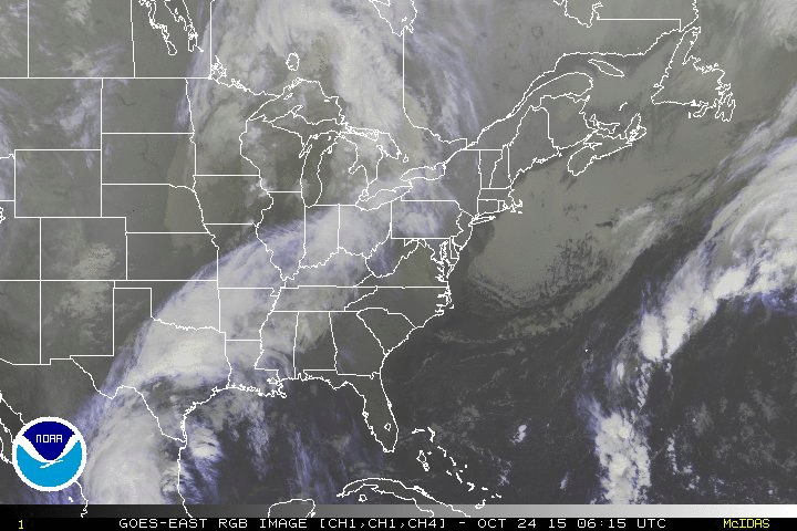
Look at this Satellite view...Patricia's circulation still clearly evident 
Been some light rain on and off during the night...now starting to get some moderate rain.
Been some light rain on and off during the night...now starting to get some moderate rain.

0 likes
The following post is NOT an official forecast and should not be used as such. It is just the opinion of the poster and may or may not be backed by sound meteorological data. It is NOT endorsed by any professional institution including storm2k.org For Official Information please refer to the NHC and NWS products.
-
Rgv20
- S2K Supporter
- Posts: 2466
- Age: 39
- Joined: Wed Jan 05, 2011 5:42 pm
- Location: Edinburg/McAllen Tx
Good Morning Discussion out of the BRO.
AREA FORECAST DISCUSSION...UPDATED
NATIONAL WEATHER SERVICE BROWNSVILLE TX
919 AM CDT SAT OCT 24 2015
.DISCUSSION...BASED ON SPEEDY MOVEMENT OF PATRICIA`S REMNANTS AS
WELL AS THE FUSE-IN WITH THE APPROACHING LONG WAVE TROUGH HAVE
MADE A COUPLE OF TIMING ADJUSTMENTS TO THE RAINFALL FLOOD AND
COASTAL FLOOD HAZARDS THIS MORNING.
FOR RAINFALL FLOOD: THE EXPECTED TIME OF THE `WORST` IS NOW
CLEARLY IN FOCUS...AND FAVORS EARLY-MID AFTERNOON THROUGH MIDNIGHT
AS PATRICIA`S REMNANTS AND THE CORE OF THE SHORT WAVE ENERGY
COMBINE TO PRODUCE AN INTENSIFYING SURFACE LOW THAT JUMPS TO
POINTS JUST EAST OF BAFFIN BAY BY 1 AM SUNDAY...CRUISING NORTHEAST
TO EAST OF PORT O`CONNOR BY DAYBREAK SUNDAY AND ALONG THE
SOUTHWEST LOUISIANA COAST BY SUNSET SUNDAY NIGHT.
THE RAPID MOVEMENT OF ALL FEATURES TAKES THE BEST FORCING WITH
IT...AND BY 12Z THE ENTIRE REGION IS IN STIFF NORTHWEST FLOW UNDER
FALL-LIKE LOW LEVEL OVERCAST WITH ONLY DRIZZLE/LIGHT RAIN
LEFT...AND SUNSHINE SHOULD FILTER IN BY AFTERNOON. WHILE THERE MAY
BE A NEED FOR AREAL FLOOD WARNINGS (POST EVENT RUNOFF WITH NO
RAIN FALLING) THE POSSIBILITY FOR A "FLASH" FLOOD DROPS TO ZERO.
THE 06Z GFS WHICH TYPICALLY HAS ISSUES WITH INITIALIZATION IS
PROBABLY BETTER THIS TIME...HAVING THE FASTER MOTION OF PATRICIA`S
REMNANTS IN PLAY.
FOR COASTAL FLOOD: RECENT REPORTS AND WEB CAMS FROM SOUTH PADRE
INDICATE STILL ROUGH SURF BUT WAVE HEIGHTS DOWN TO 4-6 FEET THIS
MORNING...AND NO INDICATION OF WATER INTO THE DUNES OVERNIGHT.
WATER LEVELS AT LOW TIDE WERE STILL ELEVATED BUT NOWHERE NEAR AS
HIGH AS THEY HAD BEEN...REFLECTIVE OF THE LOWER SWELL PERIOD AND
WAVE HEIGHTS OFFSHORE. WITH ONE MORE HIGH TIDE BEFORE WINDS SHIFT
THIS EVENING...ELECTED TO MAINTAIN THE HIGH RIP CURRENT STATEMENT
AND A COASTAL FLOOD STATEMENT FOR WATER UP NEAR THE DUNES...BUT
LET`S FACE IT WITH ALL THE RAIN COMING TODAY EXPECT FEW PEOPLE TO
BRAVE THE WEATHER.
ONE THING WE WILL KEEP AN EYE ON IS `LAGUNA SIDE` ISSUES FOR THE
SUNDAY AFTERNOON HIGH TIDE AS POTENTIALLY GALE FORCE GUSTS AND
SUSTAINED 25 TO 35 MPH WIND DRIVE ALREADY HIGH WATER EASTWARD. WE
MAY NEED TO REISSUE A COASTAL FLOOD STATEMENT FOR THIS REASON BUT
NOT FOR WEST-FACING DOCKS ON LAGUNA MADRE. WATER WILL `RUN OUT`
FROM THE BEACH WITH THE STRONG OFFSHORE FLOW.
REMAINDER OF THE FORECAST IS UNCHANGED FOR NOW.
52/BSG
&&
0 likes
The following post is NOT an official forecast and should not be used as such. It is just the opinion of the poster and may or may not be backed by sound meteorological data. It is NOT endorsed by any professional institution including storm2k.org For Official Information please refer to the NHC and NWS products.
-
Portastorm

- Storm2k Moderator

- Posts: 9955
- Age: 63
- Joined: Fri Jul 11, 2003 9:16 am
- Location: Round Rock, TX
- Contact:
Re:
Shoshana wrote:Had to empty the gauge, it was well over the 5" mark, almost to the top. It had .5" when I looked last night, so it was5"+ overnight and still raining.
Yep. Played out like I thought and the hyped rainfall values NEVER materialized here in the Austin area except for a small portion of northwestern and northern Travis County. As of 10 am, rainfall totals in Travis County range from 2.7 to 8.8 inches. I was thinking 3-4" on average and I was just a little shy of what the average is.
0 likes
Any forecasts under my name are to be taken with a grain of salt. Get your best forecasts from the National Weather Service and National Hurricane Center.
-
weatherdude1108
- Category 5
- Posts: 4228
- Joined: Tue Dec 13, 2011 1:04 pm
- Location: Northwest Austin/Cedar Park, TX
7.23 inches at my place. Lightneed up quite a bit. Here is the flood status report from LCRA
http://floodstatus.lcra.org
Widespread rainfall has been moving across the upper region of Lower Colorado River watershed since midnight tonight. Rainfall from today’s storms have ranged from 1 to over 7 inches, with the heaviest rain centered above Inks Lake and local to Lake Buchanan and over the north Austin and Cedar Park area.
The San Saba, Llano and Pedernales Rivers have risen slightly due to the storm runoff, but remain below flood stage.
Inks, Wirtz, and Starcke Dams are maintaining their operating ranges through hydro generation. Lake Travis is expected to continue to slowly rise through the weekend.
Floodgate operations are underway at Tom Miller Dam to pass inflows from the heavy rains in the Austin area. Lake Austin remains within its operating range.
Rainfall is currently moving through Bastrop and Fayette Counties. The Colorado River and tributaries downstream of the Highland Lakes are beginning to rise due to storm runoff and releases from Tom Miller Dam.
Additional rainfall is forecast to move through the Colorado River watershed today through tonight. The ground is saturated and any additional rain could produce significant runoff. The National Weather Service forecasts indicate a possibility of heavy rainfall continuing today and lasting through the evening. LCRA will be closely monitoring the potential for storm runoff and inflows that may need to be passed through lakes Inks, LBJ, Marble Falls and Austin. Lakes Buchanan and Travis are below full at this time, however, levels could rise if heavy rains do occur over the Highland Lakes watershed.
Last edited by weatherdude1108 on Sat Oct 24, 2015 10:29 am, edited 1 time in total.
0 likes
The preceding post is NOT an official forecast, and should not be used as such. It is only the opinion of the poster and may or may not be backed by sound meteorological data. It is NOT endorsed by any professional institution including storm2k.org. For Official Information please refer to the NHC and NWS products.
Return to “USA & Caribbean Weather”
Who is online
Users browsing this forum: No registered users and 109 guests