Looks like what the NWS was referring to with a stalled band of convection and no cold pool to keep it moving south and east.
THE WINDOW FOR HEAVY RAINFALL WILL BEGIN ON THURSDAY NIGHT AND
LAST THROUGH SATURDAY. THIS WILL OCCUR AS A SLOW MOVING BAND OF
RAIN AND STORMS ENTERS THE WESTERN ZONES THURSDAY NIGHT AND SLOWLY
TRACKS EASTWARD. WITH THE UPPER LEVEL LOW PULLING OFF TO THE
NORTHEAST...THIS WILL TEND TO LEAVE THIS BAND OF CONVECTION WITH
LITTLE MOTIVATION TO CONTINUE MOVING EASTWARD AS EVIDENCED BY THE
FORECAST MCS PROPAGATION VECTORS DROPPING TO 0 KNOTS FRIDAY
MORNING. NOW THE UNCERTAINTY IS THAT OFTEN TIMES SYNOPTIC MODELS
UNDERESTIMATE THE STRENGTH OF THE COLD POOL...WHICH CAN HELP
THESE LINES MOVE TOWARD THE EAST/SOUTHEAST FASTER THAN FORECAST.
HOWEVER TRYING TO PREDICT THIS WITHOUT THE HIGH-RES CONVECTION
ALLOWING MODELS IS DIFFICULT.
Texas Fall-2015
Moderator: S2k Moderators
Forum rules

The posts in this forum are NOT official forecast and should not be used as such. They are just the opinion of the poster and may or may not be backed by sound meteorological data. They are NOT endorsed by any professional institution or STORM2K.
-
1900hurricane

- Category 5

- Posts: 6063
- Age: 34
- Joined: Fri Feb 06, 2015 12:04 pm
- Location: Houston, TX
- Contact:
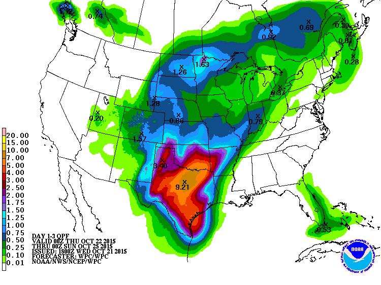
Just eyeballing it, the 12Z GFS has low level trajectories more off the Caribbean, which for a large part explains the sharp increase in rainfall totals this run. I might post another HYSPLIT off this run once it's completely finished. Big time PW reservoir over S TX too (perhaps overdone?).
0 likes
Contract Meteorologist. TAMU & MSST. Fiercely authentic, one of a kind. We are all given free will, so choose a life meant to be lived. We are the Masters of our own Stories.
Opinions expressed are mine alone.
Follow me on Twitter at @1900hurricane : Read blogs at https://1900hurricane.wordpress.com/
Opinions expressed are mine alone.
Follow me on Twitter at @1900hurricane : Read blogs at https://1900hurricane.wordpress.com/
-
TheProfessor

- Professional-Met

- Posts: 3506
- Age: 29
- Joined: Tue Dec 03, 2013 10:56 am
- Location: Wichita, Kansas
Don't look now but the end of the 12z GFS has another EPAC System, it doesn't re-curve it, but it's way far out of course, We'd be right back where we were in Spring if 2 very similar setups were to happen within a 15 day period.
0 likes
An alumnus of The Ohio State University.
Your local National Weather Service office is your best source for weather information.
Your local National Weather Service office is your best source for weather information.
-
Tireman4

- S2K Supporter

- Posts: 5903
- Age: 60
- Joined: Fri Jun 30, 2006 1:08 pm
- Location: Humble, Texas
- Contact:
What was the last sentence? An afterthought?
954
FXUS64 KHGX 211758
AFDHGX
AREA FORECAST DISCUSSION
NATIONAL WEATHER SERVICE HOUSTON/GALVESTON TX
1258 PM CDT WED OCT 21 2015
.AVIATION...
MVFR CIGS OF 1500-2600 FT STARTING TO SCATTER OUT WITH HEATING
(VFR MOST SITES BY 19Z IF NOT SOONER) AND WINDS INCREASING AS
DEEPER MIXING OCCURS. SCATTERED SHOWERS SW OF SGR TO PSX WILL
STREAM TOWARD HILL COUNTRY AS WINDS INCREASE BUT WILL PROBABLY
DIMINISH IN COVERAGE OVER SETX. WINDS OF 10-20 KNOTS FROM THE
E-SE WILL PREVAIL THIS AFTERNOON THEN DIMINISH EARLY THIS EVENING.
VFR CIGS SHOULD TRANSITION OVER TO A LOW ST DECK BY 07-09Z
600-1200 FT AND PROBABLY LOWERING NEAR 12Z. ONSET OF NEXT ROUND OF
SHOWERS IS TRICKY...MODEL SOLUTIONS DIFFER A GOOD DEAL. LARGE POOL
OF MOISTURE IN GULF SHOULD TRACK NW WITH THE NORTHERN PERIPHERY
CLIPPING THE SOUTHERN TERMINALS AFTER 09Z PROBABLY PEAKING AROUND
12Z THEN DRIER AIR SNEAKS IN FOR A PERIOD OF TIME. NAM HAS A VERY
IMPRESSIVE S/W (ASSOCIATED WITH THE PW POOL) THAT ROTATES NORTH
INTO THE AREA THURSDAY AFTERNOON AND COULD BECOME A FOCUS FOR MORE
SHRA/TSRA BUT TIMING THIS IS QUESTIONABLE ATTM. SO FOR NOW WILL
CARRY A VCSH AFTER 09Z CLL-IAH-GLS FOLLOWED BY A LATE MORNING
BREAK - THEN AT 21Z+/1022 FOR THE OUT PERIOD AT IAH BUT THIS WILL
LIKELY NEED ADJUSTING.
45
SHOWERS IN THE WEST
0 likes
-
1900hurricane
- Category 5
- Posts: 6063
- Age: 34
- Joined: Fri Feb 06, 2015 12:04 pm
- Location: Houston, TX
- Contact:
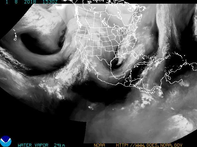
Here's the PW pool I mentioned at tau 72, which is feeding the modeled north central Texas MCS. That's a deeply Caribbean airmass. You can also see the sharp PW gradient east of south Texas that signifies the boundary between the maritime tropical airmass from the Caribbean and the modified continental airmass originating near the east coast.

0 likes
Contract Meteorologist. TAMU & MSST. Fiercely authentic, one of a kind. We are all given free will, so choose a life meant to be lived. We are the Masters of our own Stories.
Opinions expressed are mine alone.
Follow me on Twitter at @1900hurricane : Read blogs at https://1900hurricane.wordpress.com/
Opinions expressed are mine alone.
Follow me on Twitter at @1900hurricane : Read blogs at https://1900hurricane.wordpress.com/


Euro isn't as prolific as the GFS 4-6" with an area near 8-10 just to the south and east of DFW
Edit: Euro has 10-14+ inches of rain for Kaufman, Ellis, and southeastern Dallas counties
Edit: Euro has 10-14+ inches of rain for Kaufman, Ellis, and southeastern Dallas counties
0 likes
The above post and any post by Ntxw is NOT an official forecast and should not be used as such. It is just the opinion of the poster and may or may not be backed by sound meteorological data. It is NOT endorsed by any professional institution including Storm2k. For official information, please refer to NWS products.
Help support Storm2K!
-
Rgv20

- S2K Supporter
- Posts: 2466
- Age: 39
- Joined: Wed Jan 05, 2011 5:42 pm
- Location: Edinburg/McAllen Tx
Looks like Texas is going to get a good drink out of this! For Deep South Texas it looks like Saturday is going to be the wettest day down here, I'm expecting rainfall accumulations from 2-4 inches from Saturday Morning to Sunday Morning.
0 likes
The following post is NOT an official forecast and should not be used as such. It is just the opinion of the poster and may or may not be backed by sound meteorological data. It is NOT endorsed by any professional institution including storm2k.org For Official Information please refer to the NHC and NWS products.
-
weatherdude1108
- Category 5
- Posts: 4228
- Joined: Tue Dec 13, 2011 1:04 pm
- Location: Northwest Austin/Cedar Park, TX
Bob Rose:
The trough of low pressure over the southwest is forecast to slowly track to the east tonight and Thursday, turning northeast and moving across the Panhandle region Friday into Friday night. Atmospheric lift associated with the approaching trough is forecast to spread across Central and South Texas Friday into Saturday. This should result in a fairly widespread coverage of rain showers and thunderstorms Thursday through Saturday. Moderate to occasionally heavy rain should develop during this period as very rich tropical moisture arrives from the southern Gulf of Mexico. Middle and high-level moisture from eastern Pacific tropical storm Patricia is also forecast to spread north across Texas Friday into Saturday. Looking back at previous Octobers where rich Gulf and Pacific moisture sources have intersected across Texas in advance of an approaching storm system, this has often resulted in the development of widespread heavy and sometimes flooding rains. Today's forecast data suggests weather conditions across our region Thursday through Sunday will be somewhat similar.
http://www.lcra.org/water/river-and-wea ... ather.aspx
0 likes
The preceding post is NOT an official forecast, and should not be used as such. It is only the opinion of the poster and may or may not be backed by sound meteorological data. It is NOT endorsed by any professional institution including storm2k.org. For Official Information please refer to the NHC and NWS products.
-
srainhoutx

- S2K Supporter
- Posts: 6919
- Age: 68
- Joined: Sun Jan 14, 2007 11:34 am
- Location: Haywood County, NC
- Contact:
Re: Texas Fall-2015
The afternoon Model Diagnostic Discussion suggests a slower ejection of the shortwave out of the Desert SW/Four Corners Region this weekend (which is the second 500mb disturbance) making it the most likely solution. The Canadian was totally discounted since it was way too fast pushing East. Therefore the model consensus is trending toward a wetter and possibly a bit more prolonged evolution of the heavy rainfall event Thursday throughout the weekend and possibly extending into Monday mainly across E Texas into Louisiana. All the guidance develops a Coastal Low now further adding to the lifting mechanisms.
0 likes
Carla/Alicia/Jerry(In The Eye)/Michelle/Charley/Ivan/Dennis/Katrina/Rita/Wilma/Ike/Harvey
Member: National Weather Association
Wx Infinity Forums
http://wxinfinity.com/index.php
Facebook.com/WeatherInfinity
Twitter @WeatherInfinity
Member: National Weather Association
Wx Infinity Forums
http://wxinfinity.com/index.php
Facebook.com/WeatherInfinity
Twitter @WeatherInfinity
-
BrokenGlassRepublicn
- Category 1

- Posts: 483
- Joined: Sun Nov 20, 2011 8:07 pm
- Location: Richardson, Texas
Re: Texas Fall-2015
srainhoutx wrote:All the guidance develops a Coastal Low now further adding to the lifting mechanisms.
When does the coastal low develop and could it impact moisture flow to North Texas?
0 likes
-
weatherdude1108
- Category 5
- Posts: 4228
- Joined: Tue Dec 13, 2011 1:04 pm
- Location: Northwest Austin/Cedar Park, TX
Nothing new here except the a marginal risk of severe thunderstorms Friday and a slight chance for rain next Tuesday from another upper level trough.
I think El Nino is starting to show itself.
AREA FORECAST DISCUSSION
NATIONAL WEATHER SERVICE AUSTIN/SAN ANTONIO TX
310 PM CDT WED OCT 21 2015
.SHORT TERM (TONIGHT THROUGH THURSDAY NIGHT)...
UPPER AIR ANALYSIS THIS MORNING SHOWED A LOW AMPLITUDE RIDGE FROM
LOUISIANA TO THE CENTRAL PLAINS AND A LOW CENTERED OVER ARIZONA.
THE FLOW OVER TEXAS WAS TURNING FROM SOUTHWEST TO WEST. WATER
VAPOR SATELLITE IMAGERY SHOWS MID-LEVEL MOISTURE MOVING ACROSS
MEXICO FROM THE PACIFIC INTO SOUTH TEXAS. AT THE SURFACE...HIGH
PRESSURE WAS CENTERED TO OUR NORTHEAST AND WINDS ARE FROM THE
SOUTHEAST. THERE IS A FRONTAL BOUNDARY ACROSS KANSAS AND COLORADO.
DEW POINT TEMPERATURES ARE IN THE MIDDLE 60S TO LOWER 70S WHICH IS
8 TO 10 DEGREES HIGHER THAN 24 HOURS AGO. THE UPPER LOW WILL TRACK
TO THE NORTHEAST DURING THIS PERIOD AND THE MAIN TROUGH WILL MOVE
SLOWLY TOWARD THE EAST BRINGING SOUTHWESTERLY FLOW TO TEXAS.
SOUTHEASTERLY FLOW WILL CONTINUE IN THE LOW LEVELS AND THIS WILL
LEAD TO INCREASING MOISTURE IN THE BOUNDARY LAYER. PW WILL
INCREASE TO NEAR 2.1 INCHES ACROSS THE EASTERN HALF OF THE CWA.
SHOWERS AND ISOLATED THUNDERSTORMS WILL CONTINUE INTO THE EVENING
AND OVERNIGHT. AS MOISTURE INCREASES...THE ATMOSPHERE WILL BECOME
MORE UNSTABLE MAKING RAIN MORE LIKELY. CHANCES FOR LOCALLY HEAVY
RAIN WILL BEGIN THURSDAY AFTERNOON ACROSS THE EASTERN HALF OF THE
CWA. THERE IS ALSO A MARGINAL RISK OF SEVERE THUNDERSTORMS DURING
THE AFTERNOON AND EVENING.
&&
.LONG TERM (FRIDAY THROUGH WEDNESDAY)...
THE UPPER LEVEL TROUGH WILL BEGIN TO LIFT TO THE NORTHEAST FRIDAY.
PW WILL REMAIN HIGH AND CHANCES FOR THUNDERSTORMS WILL CONTINUE.
FRIDAY LOCALLY HEAVY RAIN WILL AGAIN BE POSSIBLE OVER THE EASTERN
HALF OF THE CWA. SATURDAY THE REMNANTS OF TROPICAL STORM PATRICIA
WILL BE PULLED TO THE NORTHEAST ACROSS MEXICO. TO SUM UP...LOCALLY
HEAVY RAIN WILL BE POSSIBLE OVER THE EASTERN HALF OF THE CWA
STARTING THURSDAY AND CONTINUING THROUGH SATURDAY NIGHT. RAINFALL
TOTALS WILL BE FOUR TO SEVEN INCHES WITH ISOLATED TOTALS TO 10. A
FLASH FLOOD WATCH WILL LIKELY BE NEEDED AS WE GET CLOSER TO THE
EVENT. THERE IS ALSO A MARGINAL RISK OF SEVERE THUNDERSTORMS
FRIDAY. BY SUNDAY THE TROUGH WILL HAVE MOVED AWAY AND THE UPPER
PATTERN WILL BECOME NEARLY ZONAL. ANOTHER UPPER LEVEL TROUGH WILL
MOVE ACROSS TUESDAY INTO WEDNESDAY. THERE WILL BE A SLIGHT CHANCE
FOR RAIN TUESDAY ACROSS THE EAST.
0 likes
The preceding post is NOT an official forecast, and should not be used as such. It is only the opinion of the poster and may or may not be backed by sound meteorological data. It is NOT endorsed by any professional institution including storm2k.org. For Official Information please refer to the NHC and NWS products.
We are not the only folks dealing with this. Patricia is getting organized fast. Mexico may be dealing with a powerful major landfall before her remnants gets pulled north.
0 likes
The above post and any post by Ntxw is NOT an official forecast and should not be used as such. It is just the opinion of the poster and may or may not be backed by sound meteorological data. It is NOT endorsed by any professional institution including Storm2k. For official information, please refer to NWS products.
Help support Storm2K!
Help support Storm2K!

FWD just issued a flash flood watch for all of the CWA from 10/23 1AM to 10/25 1AM.
0 likes
The above post and any post by dhweather is NOT an official forecast and should not be used as such. It is just the opinion of the poster and may or may not be backed by sound meteorological data. It is NOT endorsed by any professional institution including storm2k.org. For official information, please refer to NWS products.
-
Tireman4
- S2K Supporter
- Posts: 5903
- Age: 60
- Joined: Fri Jun 30, 2006 1:08 pm
- Location: Humble, Texas
- Contact:
Look out....it is starting to get serious....
FXUS64 KHGX 212027
AFDHGX
AREA FORECAST DISCUSSION
NATIONAL WEATHER SERVICE HOUSTON/GALVESTON TX
327 PM CDT WED OCT 21 2015
.DISCUSSION...
SCATTERED SHOWERS HAVE DEVELOPED TODAY MAINLY AROUND AND SOUTH OF
A GALVESTON BAY TO HOUSTON TO BRYAN/COLLEGE STATION LINE. THE NEXT
SURGE OF MOISTURE AND ASSOCIATED SHOWERS AND THUNDERSTORMS HAS BEEN
DEVELOPING IN THE WESTERN GULF TODAY...AND THIS ACTIVITY WILL BE
MOVING INTO THE TEXAS GULF COAST TONIGHT AND TOMORROW. HAVE RAISED
OUR AREA`S RAIN CHANCES IN RESPONSE TO THIS FEATURE WITH THE HIGHER
VALUES ACROSS OUR WESTERN COUNTIES. PERIODS OF SHOWERS AND THUNDERSTORMS
CAN BE EXPECTED THURSDAY NIGHT THROUGH FRIDAY NIGHT AS HIGHISH MOISTURE
LEVELS PERSIST BETWEEN MID/UPPER LEVEL RIDGING TO OUR EAST AND MID/UPPER
LEVEL TROUGHING TO OUR WEST. THE WEEKEND LOOKS VERY WET AS MOISTURE
LEVELS RISE AND LIFT INCREASES IN RESPONSE TO A SERIES OF DISTURBANCES
(INCLUDING THE REMNANTS OF PATRICIA CURRENTLY SOUTH SOUTHEAST OF ACAPULCO)
RIDING ACROSS THE AREA FROM THE SOUTHWEST. HOW MUCH RAIN OUR AREA RECEIVES
AND WHEN THE GREATEST RISK FOR HEAVY RAINFALL COMES TO AN END COULD
BE INFLUENCED BY THE LOCATION/STRENGTH/MOVEMENT OF SURFACE LOW PRESSURE
EXPECTED TO FORM OFF THE TEXAS COAST OVER THE WEEKEND. THROUGH SUNDAY...
WILL CALL FOR RAINFALL TOTALS OF 2 TO 4 INCHES TO THE EAST OF INTERSTATE
45 AND 4 TO 6 INCHES TO THE WEST OF INTERSTATE 45. LOCALLY HEAVY RAINFALL
WILL BE POSSIBLE...ESPECIALLY SATURDAY THROUGH SUNDAY MORNING...WHICH
WOULD RESULT IN EVEN HIGHER RAINFALL AMOUNTS. FLASH FLOOD WATCHES MIGHT
BE NEEDED. EXPECT TO SEE DECREASING RAIN CHANCES GENERALLY FROM WEST
TO EAST DURING THE FIRST HALF OF NEXT WEEK AS THIS STORM SYSTEM SLOWLY
MOVES OFF TO THE EAST AND OUT OF OUR AREA. 42
&&
.MARINE...
VERY ACTIVE STORMY PERIOD AHEAD. CURRENTLY 8-10 SECOND PERIOD 5-8
FOOT SEAS WITH EAST WINDS AROUND 15-20 KNOTS. WILL EXTEND THE SCA
FOR MATAGORDA BAY AND THE GULF WATERS AND SCEC FOR GALVESTON BAY
THROUGH 00Z FRIDAY. WINDS SHOULD INCREASE TONIGHT AND SLOW INCREASE
IN SEAS WILL BE LIKELY WITH 8-10 FOOT SEAS POSSIBLE. WINDS THEN COME
DOWN A FEW KNOTS THURSDAY MORNING BUT THEN INCREASE AGAIN THURSDAY
NIGHT WHICH MAY COME CLOSE TO 20 KNOTS OVER THE WATERS BEYOND 20NM.
LONG FETCH WITH WINDS OF NEAR 20 KNOTS OVER THE CENTRAL GULF WILL
KEEP THE SWELL TRAIN GOING AND WITH THOSE ARRIVING THURSDAY NIGHT
EXPECT SEAS OF 6 FEET NEARSHORE TO 8-10 FEET OFFSHORE. OVERALL
LITTLE CHANGES EXPECTED THROUGH SUNDAY MORNING. MODEL SOLUTIONS
DIFFER ON TRACK OF SURFACE LOW/COASTAL TROUGH WITH SOME SOLUTIONS
SHOWING WINDS NEAR 30 KNOTS AND SEAS 11+ FEET. FOR NOW HAVE KEPT
SOLUTION MORE IN LINE WITH ECMWF WITH LOW TRACKING A LITTLE FARTHER
OFFSHORE SUNDAY EVENTUALLY TURNING WINDS TO THE NORTHEAST AND
POSSIBLY EVEN NORTH. CONFIDENCE IS LOW FOR SATURDAY THROUGH SUNDAY
WITH WILDLY VARYING SOLUTIONS AND A WIDE SPECTRUM OF SOLUTIONS. SO
PUT MORE SIMPLY IT IS TOO EARLY TO JUMP ON A GIVEN SOLUTION.
COASTAL FLOODING WILL CONTINUE THROUGH THE WEEKEND AND AGAIN IS
HIGHLY DEPENDENT ON TRACK AND INTENSITY OF LOW PRESSURE SYSTEM. A
GOOD BET IS THAT LONG PERIOD SWELLS AND ELEVATED TIDES WILL MAINTAIN
THE BEACH FLOODING AND PERIODICALLY WITH HIGH TIDE MAY WORSEN AND
IMPACT THOSE BEACH FLOODING FLOOD PRONE SITES. IF WORST CASE PANS
OUT THEN SATURDAY AND SUNDAY BOLIVAR FERRY SERVICE IMPACTED AS WELL
AS CRYSTAL/JAMAICA BEACH AND KEMAH HAVING SIGNIFICANT IMPACTS.
45
0 likes
Re: Texas Fall-2015
srainhoutx wrote:The afternoon Model Diagnostic Discussion suggests a slower ejection of the shortwave out of the Desert SW/Four Corners Region this weekend (which is the second 500mb disturbance) making it the most likely solution. The Canadian was totally discounted since it was way too fast pushing East. Therefore the model consensus is trending toward a wetter and possibly a bit more prolonged evolution of the heavy rainfall event Thursday throughout the weekend and possibly extending into Monday mainly across E Texas into Louisiana. All the guidance develops a Coastal Low now further adding to the lifting mechanisms.
This is reminding me of the South Carolina flooding event. I doubt we see 15" in the metroplex, but I cannot rule it out. Someone is going to see a tremendous amount of rain and flash flooding, the only question is where.
0 likes
The above post and any post by dhweather is NOT an official forecast and should not be used as such. It is just the opinion of the poster and may or may not be backed by sound meteorological data. It is NOT endorsed by any professional institution including storm2k.org. For official information, please refer to NWS products.
Re: Texas Fall-2015
12Z GFS for Mesquite

0 likes
The above post and any post by dhweather is NOT an official forecast and should not be used as such. It is just the opinion of the poster and may or may not be backed by sound meteorological data. It is NOT endorsed by any professional institution including storm2k.org. For official information, please refer to NWS products.
-
weatherdude1108
- Category 5
- Posts: 4228
- Joined: Tue Dec 13, 2011 1:04 pm
- Location: Northwest Austin/Cedar Park, TX
Re: Texas Fall-2015
dhweather wrote:srainhoutx wrote:The afternoon Model Diagnostic Discussion suggests a slower ejection of the shortwave out of the Desert SW/Four Corners Region this weekend (which is the second 500mb disturbance) making it the most likely solution. The Canadian was totally discounted since it was way too fast pushing East. Therefore the model consensus is trending toward a wetter and possibly a bit more prolonged evolution of the heavy rainfall event Thursday throughout the weekend and possibly extending into Monday mainly across E Texas into Louisiana. All the guidance develops a Coastal Low now further adding to the lifting mechanisms.
This is reminding me of the South Carolina flooding event. I doubt we see 15" in the metroplex, but I cannot rule it out. Someone is going to see a tremendous amount of rain and flash flooding, the only question is where.
I would say the Highland Lakes watershed could use it, but they are doing pretty well from the Spring rains and there isn't much of a cushion to take on as much. Still way below full, but we saw how fast Travis and Buchanan can rise in Spring (Travis) and July (Buchanan) if a storm is parked over the right area. Travis and Buchanan combined are at 1,433,795 Acre-Feet (71%).
Lake Travis

Lake Buchanan

http://hydromet.lcra.org/full.aspx
0 likes
The preceding post is NOT an official forecast, and should not be used as such. It is only the opinion of the poster and may or may not be backed by sound meteorological data. It is NOT endorsed by any professional institution including storm2k.org. For Official Information please refer to the NHC and NWS products.
Re: Texas Fall-2015
12Z GFS at the big airport

0 likes
The above post and any post by dhweather is NOT an official forecast and should not be used as such. It is just the opinion of the poster and may or may not be backed by sound meteorological data. It is NOT endorsed by any professional institution including storm2k.org. For official information, please refer to NWS products.
-
weatherdude1108
- Category 5
- Posts: 4228
- Joined: Tue Dec 13, 2011 1:04 pm
- Location: Northwest Austin/Cedar Park, TX
Re:
Ntxw wrote:We are not the only folks dealing with this. Patricia is getting organized fast. Mexico may be dealing with a powerful major landfall before her remnants gets pulled north.
Look at that moisture tap!
0 likes
The preceding post is NOT an official forecast, and should not be used as such. It is only the opinion of the poster and may or may not be backed by sound meteorological data. It is NOT endorsed by any professional institution including storm2k.org. For Official Information please refer to the NHC and NWS products.
-
gboudx

- S2K Supporter
- Posts: 4090
- Joined: Thu Sep 04, 2003 1:39 pm
- Location: Rockwall, Tx but from Harvey, La
From jeff:
Extended period of unsettled weather heading for Texas.
Interesting feature has developed over the western Gulf of Mexico this afternoon with numerous thunderstorms. While models suggest a surge of deeper moisture, visible satellite images indicate a weakly defined rotation to the cloud pattern suggesting possibly a mid level disturbance that may have ejected out of the Bay of Campeche. Numerous thunderstorms accompany this feature as it is approaching the TX coast from the SE. Meso scale models are not really picking up on this feature…maybe the 4km WRF-NMM, but the TX Tech model does not see it. WRF-NMM really hammers our SW counties late tonight and much of the day tomorrow with excessive rainfall and extrapolation of the “vort” over the western Gulf would fall in line with that thinking while much of the rest of the guidance keeps things more on the scattered side. Will need to keep an eye on radar trends as this feature moves toward the coast.
Upper level storm system over the SW US will combine with TS Patricia off the west Mexico coast to produce a prolonged rainfall event over much of Texas from Thursday into Tuesday of next week.
Friday:
Upper level dynamics will move into western and central TX while rich tropical moisture from the Bay of Campeche lifts northward into TX. A batch of dry air over the SE US may move into SE TX on Friday keeping the highest rain chances aimed at the coastal bend into central and north TX. Friday will also feature the landfall of Hurricane Patricia on the west coast of Mexico and its associated moisture starting to lift northward over central Mexico
Weekend:
Upper trough edges closer to TX while mid and high level moisture and upper level vort from Patricia lifts NNE into TX. Expect numerous thunderstorms to develop from Saturday afternoon through Sunday night with potential for periods of sustained cell training in south to north bands. PWS surge to 2.3-2.5 inches (+2 SD above normal for late Oct). Lift will be sustained from the upper level trough and Patricia “vort” along with developing coastal trough. Weak frontal boundary comes into play on Sunday and only helps to enhance the heavy rainfall threat. As it that is not enough…models are attempting to develop a coastal low either on the weak front or as a surface reflection of the upper level remains of Patricia (this would be similar to a decaying Gulf of Mexico hurricane forming a surface reflection days later off the US east coast). The GFS and ECWMF models want to then linger this system off the TX coast into the middle of next week which would only keep rain chances going longer into next week.
Rainfall Amounts:
Models continue to advertise heavy totals of anywhere from 5-15 inches over the next 5-days over portions of the state. Two main areas are starting to indicate enhanced potential.
1) N TX into SE OK
2) TX coastal bend into SC TX and the SW/W portions of SE TX
While these two areas appear the current primed target for the maximum rainfall…these areas have been shifting around some and the overall pattern will support excessive rainfall over a large portion of TX so I would not put much confidence in the exact areas of heavy rainfall at this time.
One interesting aspect that does continue to show up in many of the models is a wedge of dry air that seems to not want to dislodge over EC TX into portions of SE TX and this continues to cut back rainfall amounts from Houston northeastward. This appears to be a function of the alignment of the surface high and recirculation of dry air over the SE US based on 850mb wind trajectories. Such trajectories show the air mass flowing into the coastal bend originating in the Caribbean Sea while that flow into areas east of I-45 are originating in a much drier air mass off the SC coast. At some point the moisture from Patricia will likely overcome this dry air surge…but this could lead to vast rainfall total differences over SE TX.
Will go with widespread 3-5 inches west of I-45 and 2-4 inches E of I-45. Isolated locations could easily see 10 inches especially the Matagorda Bay region up toward College Station.
While grounds are very dry, widespread significant rainfall is certainly going to produce run-off at some point. Flash Flood guidance is around 5-6 inches for all of our counties, but gradual saturation of the soil layer is expected over time. Wildcard may end up being just where and how much rain falls tomorrow from the “vort” approaching the TX coast this afternoon as this could lead to early ground saturation and much more significant run-off during the weekend period.
Tides:
Continue to have issues at high tide on Bolivar with overwash of HWY 87 just west of HWY 124. Tides continue to run 1-2 ft above normal and see no reason that is going to change into the weekend with sustained 15-25mph onshore winds. Tides on the west side of Galveston and Matagorda Bays have been averaging around 3.0 ft total water level which is about 1-1.5 ft below coastal flood warning criteria. Do not think we will reach warning criteria over the next several days…but a coastal flood advisory will remain in effect since some minor overwash is already occurring with current levels.
Tides Sunday into Monday will depend on what if anything transpires off the coast with respect to any sort of non-tropical surface low formation. Such a feature if it were to develop would certainly increase winds and seas and given already higher than normal tides, if would not take much to push water levels above critical flood thresholds.
Summary of Changes:
· Potential for heavy rains tonight/Thursday around Matagorda Bay and southwest counties
· Delayed onset of heavy rainfall event from Friday to Saturday over SE TX with arrival of remains of TC Patricia
· Extend duration of the event into Monday, possibly Tuesday
Highlights:
· Heaviest rainfall likely west of I-45
· Some flooding will be possible over the weekend especially Sunday
· Rises on area rivers possible early next week
· Coastal tides will remain 1-2 ft above normal with some overwash on Bolivar at high tide
0 likes
Return to “USA & Caribbean Weather”
Who is online
Users browsing this forum: No registered users and 144 guests