Texas Fall-2015

U.S. & Caribbean Weather Discussions and Severe Weather Events

Moderator: S2k Moderators

Forum rules

The posts in this forum are NOT official forecast and should not be used as such. They are just the opinion of the poster and may or may not be backed by sound meteorological data. They are NOT endorsed by any professional institution or STORM2K.

Help Support Storm2K
Message
Author
User avatar
dhweather
S2K Supporter
S2K Supporter
Posts: 6199
Joined: Sat Aug 14, 2004 9:29 pm
Location: Heath, TX
Contact:

Re: Texas Fall-2015

#881 Postby dhweather » Thu Oct 15, 2015 7:31 am

[quote="Brent"]How's this for a pattern change? :P :lol:

Image


CAT 5 IN THE GULF !!!!
:lol: :lol: :lol: :lol:


I seriously don't want that to happen, because overwhelming odds are if something tropical develops, it will get pulled north, and we will end up on the dry side. If it would follow I-45, I'd take it, but that's not going to happen in late October, climo says so.
0 likes   
The above post and any post by dhweather is NOT an official forecast and should not be used as such. It is just the opinion of the poster and may or may not be backed by sound meteorological data. It is NOT endorsed by any professional institution including storm2k.org. For official information, please refer to NWS products.

User avatar
dhweather
S2K Supporter
S2K Supporter
Posts: 6199
Joined: Sat Aug 14, 2004 9:29 pm
Location: Heath, TX
Contact:

Re: Texas Fall-2015

#882 Postby dhweather » Thu Oct 15, 2015 7:35 am

I just looked, That's EXACTLY what is going to happen. :grr: :grr: :grr: :grr:


Image
0 likes   
The above post and any post by dhweather is NOT an official forecast and should not be used as such. It is just the opinion of the poster and may or may not be backed by sound meteorological data. It is NOT endorsed by any professional institution including storm2k.org. For official information, please refer to NWS products.

User avatar
Ntxw
Storm2k Moderator
Storm2k Moderator
Posts: 22786
Joined: Wed Oct 21, 2009 6:34 pm
Location: DFW, Texas

#883 Postby Ntxw » Thu Oct 15, 2015 8:16 am

A Texas landfalling system past early October is very unlikely. Has it ever happened? I cannot recall ever seeing that happen. I wouldn't bet on it
0 likes   
The above post and any post by Ntxw is NOT an official forecast and should not be used as such. It is just the opinion of the poster and may or may not be backed by sound meteorological data. It is NOT endorsed by any professional institution including Storm2k. For official information, please refer to NWS products.

  Help support Storm2K!
Help Support Storm2K

User avatar
CaptinCrunch
S2K Supporter
S2K Supporter
Posts: 8728
Age: 57
Joined: Mon Nov 03, 2003 4:33 pm
Location: Kennedale, TX (Tarrant Co.)

Re: Texas Fall-2015

#884 Postby CaptinCrunch » Thu Oct 15, 2015 8:35 am

NWS FTW AFD

(last 2 paragraphs)

THE FIRST PHASE OF OUR TRANSITION TO A MORE SEASONABLE REGIME WILL
BEGIN FRIDAY...AS A COLD FRONT DROPS SOUTHWARD THROUGH OUR AREA.
WHILE MOISTURE WILL BE INSUFFICIENT FOR ANY PRECIPITATION...WE
SHOULD SEE AFTERNOON READINGS DECREASE 10-15 DEGREES FROM THEIR
THURSDAY LEVELS. THIS POSITIVE TREND WILL CONTINUE THROUGH THE
WEEKEND. DESPITE THE CONTINUED PRESENCE OF AN UPPER RIDGE OVER
TEXAS...COOLER AND MOISTER EAST TO SOUTHEAST LOW LEVEL FLOW WILL
PERSIST ACROSS OUR AREA SATURDAY AND SUNDAY. AFTERNOON READINGS
WILL TOP OUT AROUND 80 IN MANY AREAS...WHICH IS MUCH CLOSER TO
NORMAL VALUES FOR MID OCTOBER.

THE SECOND...AND MORE SIGNIFICANT...TRANSITION WILL DEVELOP
THROUGH THE EARLY TO MIDDLE PART OF NEXT WEEK AS A SOUTHWESTERLY
UPPER LEVEL FLOW REGIME BECOMES ESTABLISHED ACROSS THE SOUTHERN
PLAINS. GUIDANCE STILL ADVERTISES PRONOUNCED UPPER LEVEL
FORCING...MOISTURE...AND THUS SCATTERED PRECIPITATION ACROSS NORTH
AND CENTRAL TEXAS IN THE LATE TUESDAY THROUGH THURSDAY TIMEFRAME.
BOTH THE EURO AND GFS MAINTAIN A TROUGHY REGIME OVER THE SOUTH
CENTRAL U.S. INTO THE FOLLOWING WEEKEND...AND HINT AT SURFACE
CYCLOGENESIS DEVELOPING IN THE WESTERN GULF. THE UPSHOT OF THIS
WILL BE AN INCREASED CHANCE OF UNSETTLED WEATHER FOR EASTERN
TEXAS AT LEAST...AND PERHAPS THE I-35 CORRIDOR AS WELL. THIS
AUGERS WELL FOR PUTTING AT LEAST A TINY DENT IN THE CURRENT
DROUGHT THAT AFFLICTS MUCH OF OUR AREA.

BRADSHAW
0 likes   

User avatar
Tireman4
S2K Supporter
S2K Supporter
Posts: 5853
Age: 59
Joined: Fri Jun 30, 2006 1:08 pm
Location: Humble, Texas
Contact:

Re:

#885 Postby Tireman4 » Thu Oct 15, 2015 9:49 am

Ntxw wrote:A Texas landfalling system past early October is very unlikely. Has it ever happened? I cannot recall ever seeing that happen. I wouldn't bet on it


Yes. Yes it has. Funny you should mention it. Meet Hurricane Jerry...:)


Early on October 16, Jerry made landfall on Galveston Island, Texas with winds of 85 mph (140 km/h). Less than six hours later, Jerry weakened to a tropical storm and then a tropical depression shortly thereafter. Late on October 16, Jerry was absorbed by a frontal system while situated over southwestern Arkansas.

https://en.wikipedia.org/wiki/Hurricane_Jerry_(1989)
0 likes   

User avatar
Portastorm
Storm2k Moderator
Storm2k Moderator
Posts: 9914
Age: 63
Joined: Fri Jul 11, 2003 9:16 am
Location: Round Rock, TX
Contact:

Re:

#886 Postby Portastorm » Thu Oct 15, 2015 10:29 am

gboudx wrote:I can smell smoke here in Rockwall from the Bastrop fire. Hopefully they can get it under control today.


Unfortunately that is not happening. The fire has grown to over 4,200 acres and is only 10-15% contained. We continue to have very dry and warm weather here which is conducive to more fires and fires spreading. Next week's front/rain cannot get here soon enough.
0 likes   
Any forecasts under my name are to be taken with a grain of salt. Get your best forecasts from the National Weather Service and National Hurricane Center.

User avatar
Tireman4
S2K Supporter
S2K Supporter
Posts: 5853
Age: 59
Joined: Fri Jun 30, 2006 1:08 pm
Location: Humble, Texas
Contact:

Re: Re:

#887 Postby Tireman4 » Thu Oct 15, 2015 10:32 am

Portastorm wrote:
gboudx wrote:I can smell smoke here in Rockwall from the Bastrop fire. Hopefully they can get it under control today.


Unfortunately that is not happening. The fire has grown to over 4,200 acres and is only 10-15% contained. We continue to have very dry and warm weather here which is conducive to more fires and fires spreading. Next week's front/rain cannot get here soon enough.


What started it?
0 likes   

User avatar
JDawg512
Category 5
Category 5
Posts: 1077
Age: 45
Joined: Mon Aug 26, 2013 8:56 pm
Location: Austin
Contact:

Re: Re:

#888 Postby JDawg512 » Thu Oct 15, 2015 10:41 am

Tireman4 wrote:
Portastorm wrote:
gboudx wrote:I can smell smoke here in Rockwall from the Bastrop fire. Hopefully they can get it under control today.


Unfortunately that is not happening. The fire has grown to over 4,200 acres and is only 10-15% contained. We continue to have very dry and warm weather here which is conducive to more fires and fires spreading. Next week's front/rain cannot get here soon enough.


What started it?


Unknown, at least as far as I've heard. A press conference is going on so they may say if they have determined the cause. What is known is that it looks like it started on the Leeke farm.

It's so sad to see what pine forest that did not burn in 2011 burn now. I used to go camping in those woods nearly every summer growing up. It may never return to what it once was.
0 likes   
Resident Rain Miser

I am a weather hobbyist living 3.5 miles south of Downtown Austin and in no way or fashion should anything I say concerning forecasts be taken seriously. Please check your local NWS for accurate weather forecasting and conditions.

User avatar
gboudx
S2K Supporter
S2K Supporter
Posts: 4080
Joined: Thu Sep 04, 2003 1:39 pm
Location: Rockwall, Tx but from Harvey, La

Re: Texas Fall-2015

#889 Postby gboudx » Thu Oct 15, 2015 11:30 am

dhweather wrote:I just looked, That's EXACTLY what is going to happen. :grr: :grr: :grr: :grr:


Of course. But at least the good news is this shouldn't be our only shot at precip.
0 likes   

Brent
S2K Supporter
S2K Supporter
Posts: 38090
Age: 36
Joined: Sun May 16, 2004 10:30 pm
Location: Tulsa Oklahoma
Contact:

Re: Texas Fall-2015

#890 Postby Brent » Thu Oct 15, 2015 1:29 pm

The GFS giveth and the GFS taketh away:

DFW: TOTAL PRECIP: 0.00 " and Convective: 0 "
0 likes   
#neversummer

User avatar
TheProfessor
Professional-Met
Professional-Met
Posts: 3506
Age: 28
Joined: Tue Dec 03, 2013 10:56 am
Location: Wichita, Kansas

#891 Postby TheProfessor » Thu Oct 15, 2015 1:42 pm

I'm back home! and it might be hot today, but it looks like I might have bought a cool front with me for the weekend! :D
0 likes   
An alumnus of The Ohio State University.

Your local National Weather Service office is your best source for weather information.

User avatar
SouthernMet
Category 3
Category 3
Posts: 857
Joined: Sun Aug 29, 2010 8:23 pm
Location: fort worth, tx

Re: Texas Fall-2015

#892 Postby SouthernMet » Thu Oct 15, 2015 1:56 pm

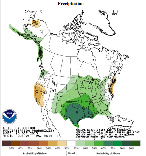
NWS Temp & Precip Outlook is much colder and wetter for texas.
0 likes   
Nothing that SouthernMet posts, is an official forecast,nor does it reflect views of STORM2K.. SouthernMet is just adding to the great discussions on STORM2K.. Refer to NWS for official forecasts.

User avatar
gboudx
S2K Supporter
S2K Supporter
Posts: 4080
Joined: Thu Sep 04, 2003 1:39 pm
Location: Rockwall, Tx but from Harvey, La

#893 Postby gboudx » Thu Oct 15, 2015 3:46 pm

Yep.

UNFORTUNATELY THE LAST COUPLE OF RUNS FROM BOTH OF
THESE MODELS ACTUALLY DEEPEN THE SYSTEM INTO A CLOSED LOW AND MOVE
IT SOUTH INTO NORTHERN MEXICO BY THE MIDDLE OF NEXT WEEK. IF THIS
SOLUTION VERIFIES IT WOULD KEEP THE BEST RAIN CHANCES WELL TO THE
WEST AND SOUTHWEST OF NORTH TEXAS THROUGH THURSDAY.

ANOTHER FLY IN THE OINTMENT WILL BE THE POTENTIAL FOR A TROPICAL
SYSTEM IN THE GULF AS BOTH MODELS HAVE BEEN INDICATING. IF THIS
DEVELOPMENT DOES OCCUR IT COULD KEEP NORTH TEXAS CUT OFF FROM ANY
DEEP TROPICAL MOISTURE DEPENDING ON WHERE THE CENTER OF THE
CIRCULATION MOVES.
0 likes   

weatherdude1108
Category 5
Category 5
Posts: 4228
Joined: Tue Dec 13, 2011 1:04 pm
Location: Northwest Austin/Cedar Park, TX

#894 Postby weatherdude1108 » Thu Oct 15, 2015 4:23 pm

EWX mentions the possible cyclone in the Gulf next week...or CAT 5 :cheesy:
Caveat to that is it may hog all the moisture if big enough! Not sure if the most recent GFS QPF run is hinting at that or not(?). :hmm:
Hopefully not. :double: :rain: :rain: :rain: :rain: :rain: :rain:

000
FXUS64 KEWX 152010
AFDEWX

AREA FORECAST DISCUSSION
NATIONAL WEATHER SERVICE AUSTIN/SAN ANTONIO TX
310 PM CDT THU OCT 15 2015

.LONG TERM (SATURDAY THROUGH THURSDAY)...A WEAK BACKDOOR FRONT
ADVECTS IN SLIGHTLY DRIER AIR IN THE LOWEST LEVELS FRIDAY NIGHT.
DRY CONDITIONS WILL CONTINUE THROUGH THE WEEKEND WITH CONTINUED
WEAK RIDGING ALOFT. SLIGHTLY COOLER TEMPERATURES...BUT STILL WELL
ABOVE NORMAL AFTERNOON HIGHS OVER THE WEEKEND.

A GRADUAL MOISTENING TREND WILL BEGIN TO TAKE PLACE FIRST UP THE
RIO GRANDE ON MONDAY AND THEN ACROSS THE ENTIRE CWA MONDAY NIGHT
INTO TUESDAY AS A TROUGH DEEPENS ACROSS THE SOUTHWEST U.S. AND
MEXICO...WITH LOW TEMPERATURES GRADUALLY MODIFYING AND A RETURN OF
OVERNIGHT STRATUS. PWAT VALUES EVENTUALLY CLIMB TO AROUND 1.5-1.7
INCHES BY TUESDAY AFTERNOON AND A FEW SHOWERS MAY BE POSSIBLE.

MODELS ARE IN AGREEMENT WITH AN UPPER LEVEL LOW EVENTUALLY
CUTTING OFF OVER NORTHERN BAJA WEDNESDAY AND THEN OPENING AND
PHASING INTO A NORTHERN STREAM TROUGH THURSDAY INTO FRIDAY OF NEXT
WEEK...REMAINING WEST OF THE AREA. AT THE SAME TIME A DEEP SLUG
OF TROPICAL MOISTURE FROM THE SOUTHERN GULF LOOKS TO ADVECT INTO
SOUTHERN AND EVENTUALLY EASTERN AREAS OF THE CWA WEDNESDAY INTO
THURSDAY...AS STRONG SOUTHEASTERLY 850MB FLOW DEVELOPS IN RESPONSE
TO THE LOW TO THE WEST. SOUTHERN AREAS ON WEDNESDAY AND EASTERN
AREAS THURSDAY COULD SEE PWATS EXCEEDING 2 INCHES...WELL ABOVE 2
STANDARD DEVIATIONS OF CLIMO FOR THIS TIME OF YEAR. IT DOES APPEAR
THERE WILL BE GOOD CHANCES FOR RAINFALL SOMETIME WEDNESDAY INTO
THURSDAY ACROSS PORTIONS OF THE CWA...ESPECIALLY SOUTHERN AND
EASTERN AREAS.
HOWEVER...POPS ARE CAPPED AT 40-50 PERCENT AT THIS
TIME AS DETAILS IN TIMING OF SYNOPTIC FORCING ARE MESSY THIS FAR
OUT. ALSO...BOTH THE GFS AND ECMWF HAVE BEEN HINTING AT THE
POSSIBILITY OF A CYCLONE DEVELOPING IN THE SOUTHERN GULF LATE NEXT
WEEK AND LIFTING NORTHEAST AS THE TROUGH TO THE WEST ADVANCES
EAST. TIMING AND DETAILS OF THIS FEATURE ARE LOW AT THE MOMENT...BUT
BEARS WATCHING FOR ITS INFLUENCE ON HOW THE DEEPER MOISTURE
EVOLVES INTO AND OVER THE AREA.
0 likes   
The preceding post is NOT an official forecast, and should not be used as such. It is only the opinion of the poster and may or may not be backed by sound meteorological data. It is NOT endorsed by any professional institution including storm2k.org. For Official Information please refer to the NHC and NWS products.

User avatar
dhweather
S2K Supporter
S2K Supporter
Posts: 6199
Joined: Sat Aug 14, 2004 9:29 pm
Location: Heath, TX
Contact:

Re: Texas Fall-2015

#895 Postby dhweather » Thu Oct 15, 2015 5:03 pm

Looks like we are getting the shaft again.


FWD AFD


AREA FORECAST DISCUSSION
NATIONAL WEATHER SERVICE FORT WORTH TX
253 PM CDT THU OCT 15 2015

.DISCUSSION...
AFTER ANOTHER HOT AND DRY AFTERNOON ACROSS NORTH TEXAS...
TEMPERATURES SHOULD COOL RAPIDLY AFTER SUNSET WITH DECREASING
WIND SPEEDS AND A MOSTLY CLEAR SKY. OVERNIGHT LOWS WILL RANGE FROM
THE UPPER 50S TO THE LOWER 60S...WITH EVEN SOME MIDDLE 60S ACROSS
THE METROPLEX.

SOME CHANGES WILL BEGIN ON FRIDAY AS A COLD FRONT MOVES ACROSS THE
REGION. THE FRONT SHOULD COME THROUGH DRY BUT WILL BRING SOME MUCH
COOLER AIR INTO NORTH TEXAS. AFTERNOON HIGHS ON FRIDAY IN MOST
SPOTS WILL BE 10 TO 15 DEGREES COOLER THAN THE PAST TWO
AFTERNOONS. THE ONLY EXCEPTION WILL BE THE SOUTHERN ZONES WHERE
TEMPERATURES SHOULD STILL REACH THE LOWER 90S BEFORE THE BRUNT OF
THE COOLER AIR ARRIVES.

THE COOLER AIR WILL REMAIN IN PLACE ACROSS NORTH TEXAS THROUGH
EARLY NEXT WEEK AND KEEP TEMPERATURES CLOSER TO SEASONAL NORMALS
WITH HIGHS GENERALLY IN THE 80S AND LOWS IN THE 50S.

UPPER LEVEL HIGH PRESSURE WILL BEGIN TO BUILD EAST TO START THE
WORK WEEK AS A TROUGH DEVELOPS ACROSS THE WESTERN UNITED STATES. BOTH
THE ECMWF AND GFS SOLUTIONS THE LAST FEW DAYS INDICATED THAT THIS
TROUGH WOULD STAY SOMEWHAT OPEN AND PROGRESSIVE AND BRING A GOOD
CHANCE OF SHOWERS AND THUNDERSTORMS TO NORTH TEXAS BY THE MIDDLE
OF NEXT WEEK. UNFORTUNATELY THE LAST COUPLE OF RUNS FROM BOTH OF
THESE MODELS ACTUALLY DEEPEN THE SYSTEM INTO A CLOSED LOW AND MOVE
IT SOUTH INTO NORTHERN MEXICO BY THE MIDDLE OF NEXT WEEK. IF THIS
SOLUTION VERIFIES IT WOULD KEEP THE BEST RAIN CHANCES WELL TO THE
WEST AND SOUTHWEST OF NORTH TEXAS THROUGH THURSDAY.

ANOTHER FLY IN THE OINTMENT WILL BE THE POTENTIAL FOR A TROPICAL
SYSTEM IN THE GULF AS BOTH MODELS HAVE BEEN INDICATING. IF THIS
DEVELOPMENT DOES OCCUR IT COULD KEEP NORTH TEXAS CUT OFF FROM ANY
DEEP TROPICAL MOISTURE DEPENDING ON WHERE THE CENTER OF THE
CIRCULATION MOVES.


FOR NOW WE HAVE DECIDED TO KEEP SOME LOW CHANCE POPS IN THE
FORECAST WEDNESDAY AND THURSDAY SINCE THIS SYSTEM STILL HAS
POTENTIAL TO STAY PROGRESSIVE. IT DOES APPEAR THAT THURSDAY WOULD
HAVE THE BEST CHANCE OF PRECIPITATION SINCE A COLD FRONT SHOULD
ENTER THE REGION THAT DAY.
0 likes   
The above post and any post by dhweather is NOT an official forecast and should not be used as such. It is just the opinion of the poster and may or may not be backed by sound meteorological data. It is NOT endorsed by any professional institution including storm2k.org. For official information, please refer to NWS products.

BrokenGlassRepublicn
Category 1
Category 1
Posts: 481
Joined: Sun Nov 20, 2011 8:07 pm
Location: Richardson, Texas

Re: Texas Fall-2015

#896 Postby BrokenGlassRepublicn » Thu Oct 15, 2015 5:55 pm

Brent wrote:The GFS giveth and the GFS taketh away:

DFW: TOTAL PRECIP: 0.00 " and Convective: 0 "

This is getting absurd. It's depressing how dry things look in Dallas these days. October is our best weather month, but this one is half over and it has been miserable.
0 likes   

gpsnowman
S2K Supporter
S2K Supporter
Posts: 3186
Joined: Fri Jan 07, 2011 10:35 am
Location: Grand Prairie Tx

Re: Texas Fall-2015

#897 Postby gpsnowman » Thu Oct 15, 2015 6:09 pm

BrokenGlassRepublicn wrote:
Brent wrote:The GFS giveth and the GFS taketh away:

DFW: TOTAL PRECIP: 0.00 " and Convective: 0 "

This is getting absurd. It's depressing how dry things look in Dallas these days. October is our best weather month, but this one is half over and it has been miserable.

I concur. October is supposed to be a big transition month with fall air and rain. Some of the mornings have been pleasant but it quickly heats up by late morning. This stinks. During yardwork today I was sweating like it was June and the a/c's are still churning. Some relief is on the horizon but my goodness, where has fall disappeared to? Weather depression setting in. :cry: :cry:
0 likes   

User avatar
dhweather
S2K Supporter
S2K Supporter
Posts: 6199
Joined: Sat Aug 14, 2004 9:29 pm
Location: Heath, TX
Contact:

#898 Postby dhweather » Thu Oct 15, 2015 7:26 pm

October has been a HUGE bust.
0 likes   
The above post and any post by dhweather is NOT an official forecast and should not be used as such. It is just the opinion of the poster and may or may not be backed by sound meteorological data. It is NOT endorsed by any professional institution including storm2k.org. For official information, please refer to NWS products.

weatherdude1108
Category 5
Category 5
Posts: 4228
Joined: Tue Dec 13, 2011 1:04 pm
Location: Northwest Austin/Cedar Park, TX

#899 Postby weatherdude1108 » Thu Oct 15, 2015 8:00 pm

This CPC El Niño Winter forecast can't get here soon enough. The damage has already been done (in the form of wildfires recently and stressed vegetation/soils). :grr:
I feel like the transitions are getting later, fewer, and farther in between than in the past. I'm just getting emotional again, seeing neverending model mirage stuff.
:rain: :rain: :rain: :firedevil: :firedevil: :firedevil:

http://www.lcra.org/water/river-and-wea ... ather.aspx
0 likes   
The preceding post is NOT an official forecast, and should not be used as such. It is only the opinion of the poster and may or may not be backed by sound meteorological data. It is NOT endorsed by any professional institution including storm2k.org. For Official Information please refer to the NHC and NWS products.

aggiecutter
Category 5
Category 5
Posts: 1753
Joined: Thu Oct 14, 2004 9:22 pm
Location: Texarkana

Re: Texas Fall-2015

#900 Postby aggiecutter » Thu Oct 15, 2015 9:11 pm

Image
0 likes   


Return to “USA & Caribbean Weather”

Who is online

Users browsing this forum: Google Adsense [Bot], mmmmsnouts and 29 guests