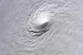
Storm cell just east of Melbourne, FL
Moderator: S2k Moderators
Forum rules

The posts in this forum are NOT official forecasts and should not be used as such. They are just the opinion of the poster and may or may not be backed by sound meteorological data. They are NOT endorsed by any professional institution or STORM2K. For official information, please refer to products from the National Hurricane Center and National Weather Service.
-
CFLHurricane

- Category 1

- Posts: 350
- Joined: Thu Mar 27, 2014 5:56 pm
- Location: Floriduh
Storm cell just east of Melbourne, FL
Has quite the impressive anvil and decent spin on the radar. Just thought I'd share 
0 likes
I'm not a meteorologist, but I did stay at a motel 8.
-
Weatherwatcher98
- Category 1
- Posts: 346
- Joined: Sat Sep 12, 2015 10:53 am
Re: Storm cell just east of Melbourne, FL
NATIONAL WEATHER SERVICE MELBOURNE FLCFLHurricane wrote:Has quite the impressive anvil and decent spin on the radar. Just thought I'd share
940 AM EDT FRI OCT 9 2015
.DISCUSSION...
THE "INTERESTING SWIRL" FROM EARLIER TODAY HAS MOVE NORTH OFF
SOUTHEAST BREVARD COUNTY BETWEEN MELBOURNE BEACH AND SEBASTIAN
INLET. THE 9AM METARS VERIFY ITS THERE WITH ONSHORE WINDS AT
THE BREVARD SITES AND OFFSHORE WINDS AT THE INDIAN RIVER AND SAINT
LUCIE METAR SITES. THE MELBOURNE WEATHER RADAR/88D WAS DETECTING
MODERATE TO HEAVY RAIN OVER THE COASTAL WATERS BETWEEN CAPE
CANAVERAL AND SEBASTIAN INLET MOVING WEST NORTHWEST TOWARD THE
BREVARD COUNTY BEACHES. RADAR WAS INDICATING SOME LIGHT SHOWERS OR
SPRINKLES COMING ASHORE MELBOURNE SOUTH. THE AWIPS ETA TOOL WAS
ESTIMATING ABOUT AN HOUR BEFORE THE HEAVIER RAIN IMPACTS THE BEACHES
AND IMMEDIATE COASTAL LOCATIONS COCOA BEACH/COCOA SOUTH. AT THE
MOMENT THE LOCAL SHORT TERM MESOSCALE MODELS (HRRR AND WRF/ARW 6KM)
HAVING SOME PROBLEMS PICKING UP ON THIS MESOSCALE FEATURE SO WILL GO
WITH RADAR TRENDS FOR THE REST OF THE MORNING/DAY.
0 likes
Personal Forecast Disclaimer:
The posts in this forum are NOT official forecast and should not be used as such. They are just the opinion of the poster and may or may not be backed by sound meteorological data. They are NOT endorsed by any professional institution or storm2k.org. For official information, please refer to the NHC and NWS products.
The posts in this forum are NOT official forecast and should not be used as such. They are just the opinion of the poster and may or may not be backed by sound meteorological data. They are NOT endorsed by any professional institution or storm2k.org. For official information, please refer to the NHC and NWS products.

Re: Storm cell just east of Melbourne, FL
It looks very good but a lot of shear. look at a visual satellite loop and you can see it is a nice low that seems to be getting better organized. The 1-km GOES shoes the low and the onshore flow noth of the cape and the off shore winds all the way down in the keys
0 likes
-
Weatherwatcher98
- Category 1
- Posts: 346
- Joined: Sat Sep 12, 2015 10:53 am
Re: Storm cell just east of Melbourne, FL
Shear or no Shear sat presentation is really good. Invest?
0 likes
Personal Forecast Disclaimer:
The posts in this forum are NOT official forecast and should not be used as such. They are just the opinion of the poster and may or may not be backed by sound meteorological data. They are NOT endorsed by any professional institution or storm2k.org. For official information, please refer to the NHC and NWS products.
The posts in this forum are NOT official forecast and should not be used as such. They are just the opinion of the poster and may or may not be backed by sound meteorological data. They are NOT endorsed by any professional institution or storm2k.org. For official information, please refer to the NHC and NWS products.
-
Weatherwatcher98
- Category 1
- Posts: 346
- Joined: Sat Sep 12, 2015 10:53 am
Re: Storm cell just east of Melbourne, FL
trave2 wrote:It looks very good but a lot of shear. look at a visual satellite loop and you can see it is a nice low that seems to be getting better organized. The 1-km GOES shoes the low and the onshore flow noth of the cape and the off shore winds all the way down in the keys
http://www.ssd.noaa.gov/goes/east/watl/h5-loop-avn.html 1016mb low
0 likes
Personal Forecast Disclaimer:
The posts in this forum are NOT official forecast and should not be used as such. They are just the opinion of the poster and may or may not be backed by sound meteorological data. They are NOT endorsed by any professional institution or storm2k.org. For official information, please refer to the NHC and NWS products.
The posts in this forum are NOT official forecast and should not be used as such. They are just the opinion of the poster and may or may not be backed by sound meteorological data. They are NOT endorsed by any professional institution or storm2k.org. For official information, please refer to the NHC and NWS products.
-
Weatherwatcher98
- Category 1
- Posts: 346
- Joined: Sat Sep 12, 2015 10:53 am
Re: Storm cell just east of Melbourne, FL
NATIONAL WEATHER SERVICE TAMPA BAY RUSKIN FLWeatherwatcher98 wrote:Shear or no Shear sat presentation is really good. Invest?
328 PM EDT FRI OCT 9 2015
.SHORT TERM (TONIGHT-SATURDAY)...
HIGH PRESSURE TO THE NORTH AND A WEAK TROUGH ACROSS SOUTH FL ARE
KEEPING ENE WINDS IN PLACE ACROSS THE AREA...WITH A SEA BREEZE
STARTING TO DEVELOP ALONG THE COAST THIS AFTERNOON. A FEW SHOWERS
ARE STARTING TO POP UP ALONG THE SEA BREEZE. SCATTERED SHOWERS
WITH A FEW EMBEDDED THUNDERSTORMS ARE EXPECTED THROUGH THE REST OF
THE AFTERNOON AND EARLY EVENING HOURS. A COLD FRONT AND UPPER
TROUGH WILL THEN BE APPROACHING THE AREA OVERNIGHT. THIS WILL KEEP
SOME SCATTERED SHOWERS AND ISOLATED THUNDERSTORMS MAINLY OVER THE
COASTAL WATERS AND THE NATURE COAST. THE SURFACE TROUGH OVER
SOUTH FL WILL THEN LIFT NORTH OVER THE STATE WITH WEAK LOW
PRESSURE FORMS OFF OF THE FL NE COAST AS THE UPPER TROUGH DEEPENS
AS IT DIGS THROUGH THE CAROLINAS. SCATTERED SHOWERS AND
THUNDERSTORMS WILL BE POSSIBLE ACROSS THE AREA THROUGH THE DAY
SATURDAY AHEAD OF THE FRONT AS WINDS BECOME MORE WESTERLY.
TEMPERATURES WILL BE GENERALLY IN THE LOWER TO MID 70S TONIGHT AND
IN THE LOWER TO MID 80S NORTH AND COASTAL...MID TO UPPER 80S
INLAND CENTRAL AND SOUTH FOR SATURDAY.
Guess not
0 likes
Personal Forecast Disclaimer:
The posts in this forum are NOT official forecast and should not be used as such. They are just the opinion of the poster and may or may not be backed by sound meteorological data. They are NOT endorsed by any professional institution or storm2k.org. For official information, please refer to the NHC and NWS products.
The posts in this forum are NOT official forecast and should not be used as such. They are just the opinion of the poster and may or may not be backed by sound meteorological data. They are NOT endorsed by any professional institution or storm2k.org. For official information, please refer to the NHC and NWS products.
Re: Storm cell just east of Melbourne, FL
Weatherwatcher98 wrote:trave2 wrote:It looks very good but a lot of shear. look at a visual satellite loop and you can see it is a nice low that seems to be getting better organized. The 1-km GOES shoes the low and the onshore flow noth of the cape and the off shore winds all the way down in the keys
http://www.ssd.noaa.gov/goes/east/watl/h5-loop-avn.html 1016mb low
Yeah, as I said visible sat image: http://weather.msfc.nasa.gov/GOES/goeseastconus.html
click on Florida and than animate
0 likes