2015 Global model runs discussion
Moderator: S2k Moderators
Forum rules

The posts in this forum are NOT official forecasts and should not be used as such. They are just the opinion of the poster and may or may not be backed by sound meteorological data. They are NOT endorsed by any professional institution or STORM2K. For official information, please refer to products from the National Hurricane Center and National Weather Service.
Re: 2015 Global model runs discussion
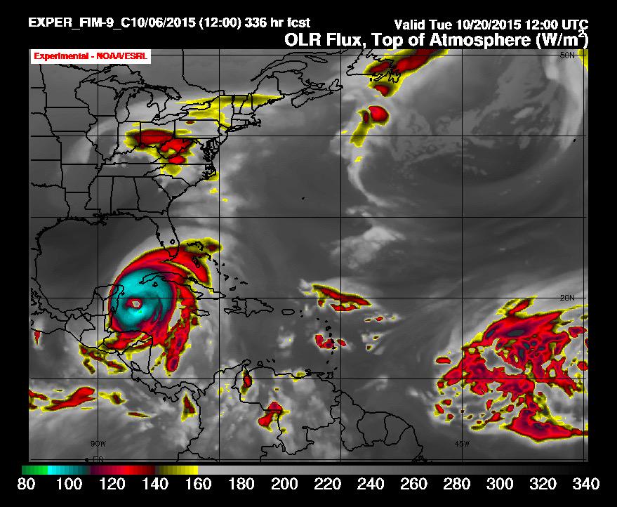
FIM also showing significant development in the West Carib https://pbs.twimg.com/media/CQuOOfWWIAAXKju.jpg on 10/20
0 likes
-
gatorcane

- S2K Supporter

- Posts: 23703
- Age: 47
- Joined: Sun Mar 13, 2005 3:54 pm
- Location: Boca Raton, FL
Re: 2015 Global model runs discussion
BobHarlem wrote:FIM also showing significant development in the West Carib https://pbs.twimg.com/media/CQuOOfWWIAAXKju.jpg on 10/20
That is yesterday's FIM, below is the 00Z run from last night:

0 likes
-
HURRICANELONNY
- Category 5

- Posts: 1390
- Joined: Wed May 07, 2003 6:48 am
- Location: HOLLYWOOD.FL
Re: 2015 Global model runs discussion
Good read about the models and why the Euro beat GFS on Joaquin.
http://www.wunderground.com/blog/JeffMa ... rynum=3148
http://www.wunderground.com/blog/JeffMa ... rynum=3148
0 likes
hurricanelonny
One thing I like to look at for long range tropical potential is the CPC's 6-10 and 8-14 day outlooks. as of now the 6-10 shows below normal precip for fl and the 8-14 day shows normal. I'd be much more interested if either of those showed above normal readings but will certainly be watching subsequent updates.
0 likes
-
WPBWeather

- S2K Supporter
- Posts: 535
- Age: 67
- Joined: Thu Jul 18, 2013 12:33 pm
Re: 2015 Global model runs discussion
0 likes


-
PTrackerLA

- Category 5
- Posts: 5280
- Age: 42
- Joined: Thu Oct 10, 2002 8:40 pm
- Location: Lafayette, LA
Re: 2015 Global model runs discussion
I don't know much about experimental NASA GEOS-5 model but here's what the 00z run showed at 240 hours:

0 likes
-
TheProfessor

- Professional-Met

- Posts: 3506
- Age: 29
- Joined: Tue Dec 03, 2013 10:56 am
- Location: Wichita, Kansas
Re:
TheProfessor wrote:Last 2 GFS Runs has a way out to sea and has the potential storm missing Florida to the south.
out to sea? What run are you looking at. It smashes half of the Caribbean and the Bahamas. We don't call those fish storms here
0 likes
-
TheProfessor
- Professional-Met
- Posts: 3506
- Age: 29
- Joined: Tue Dec 03, 2013 10:56 am
- Location: Wichita, Kansas
Re: Re:
Alyono wrote:TheProfessor wrote:Last 2 GFS Runs has a way out to sea and has the potential storm missing Florida to the south.
out to sea? What run are you looking at. It smashes half of the Caribbean and the Bahamas. We don't call those fish storms here
I didn't call it a fish storm, I said out to sea, I didn't think out to sea meant no land interaction, if it does then sorry.
0 likes
An alumnus of The Ohio State University.
Your local National Weather Service office is your best source for weather information.
Your local National Weather Service office is your best source for weather information.
-
WeatherEmperor
- S2K Supporter
- Posts: 4806
- Age: 41
- Joined: Thu Sep 04, 2003 2:54 pm
- Location: South Florida
2015 Global model runs discussion
12z Canadian has low pressure in the extreme SW Caribbean nearly stationary almost trying to move into the Epac near the end of its run at 240hours. Waiting for the Euro to start
Sent from my iPhone6 using Tapatalk
Sent from my iPhone6 using Tapatalk
0 likes
-
gatorcane
- S2K Supporter
- Posts: 23703
- Age: 47
- Joined: Sun Mar 13, 2005 3:54 pm
- Location: Boca Raton, FL
12Z GFS Ensembles continue to bullish and are bringing in the timeframe. Like the operational, most of them are south of Florida on this run but it's all in the long range. That is about as much support as you will get for development from the long-range GEFS:
4 Ensembles bring it to southern Florida

4 Ensembles bring it to southern Florida
0 likes

Re: 2015 Global model runs discussion
WeatherEmperor wrote:12z Canadian has low pressure in the extreme SW Caribbean nearly stationary almost trying to move into the Epac near the end of its run at 240hours. Waiting for the Euro to start
Sent from my iPhone6 using Tapatalk
The CMC has been showing good vorticity last several runs but it has kept it over land and further South. It does not feel the trough as much as on the GFS. If it felt the trough and gets over water I have not doubt it would spin it up more.
Also, the CMC spins up the EPAC system which draws energy away.
I think the takeaway right now with the models is that the MJO is going to impart good upward motion in the region and that the shear might be favorable.
0 likes
The following post is NOT an official forecast and should not be used as such. It is just the opinion of the poster and may or may not be backed by sound meteorological data. It is NOT endorsed by any professional institution including storm2k.org For Official Information please refer to the NHC and NWS products.
-
WeatherEmperor
- S2K Supporter
- Posts: 4806
- Age: 41
- Joined: Thu Sep 04, 2003 2:54 pm
- Location: South Florida
2015 Global model runs discussion
12z Euro is similar to the Canadian. Pushes a weak low into the Epac. Too much land interaction to allow anything to get going.
We have seen this before. The Gfs stands alone run after run after run only to end up being wrong. Unless other models joing the Gfs, its hard to take it seriously. Lets see what the models show tomorrow.
Sent from my iPhone6 using Tapatalk
We have seen this before. The Gfs stands alone run after run after run only to end up being wrong. Unless other models joing the Gfs, its hard to take it seriously. Lets see what the models show tomorrow.
Sent from my iPhone6 using Tapatalk
0 likes
-
gatorcane
- S2K Supporter
- Posts: 23703
- Age: 47
- Joined: Sun Mar 13, 2005 3:54 pm
- Location: Boca Raton, FL
Re: 2015 Global model runs discussion
WeatherEmperor wrote:12z Euro is similar to the Canadian. Pushes a weak low into the Epac. Too much land interaction to allow anything to get going.
We have seen this before. The Gfs stands alone run after run after run only to end up being wrong. Unless other models joing the Gfs, its hard to take it seriously. Lets see what the models show tomorrow.
Sent from my iPhone6 using Tapatalk
Actually the 12Z Euro has a broad low over the Yucatan. If you look at that pattern, had it developed this area over Western Caribbean like the GFS it probably would get pulled N then NE similar to the GFS.

0 likes
-
gatorcane
- S2K Supporter
- Posts: 23703
- Age: 47
- Joined: Sun Mar 13, 2005 3:54 pm
- Location: Boca Raton, FL
Well folks, we have some CMC Ensembles on board for the Western Caribbean system on the 12Z run. They develop the system over the NW Caribbean and some of them move it NNE over Cuba and South Florida. This is the first run the CMC ensembles are showing something.
Last edited by gatorcane on Wed Oct 07, 2015 2:37 pm, edited 1 time in total.
0 likes
-
WeatherEmperor
- S2K Supporter
- Posts: 4806
- Age: 41
- Joined: Thu Sep 04, 2003 2:54 pm
- Location: South Florida
2015 Global model runs discussion
Gator can u post the ensembles?
Sent from my iPhone6 using Tapatalk
Sent from my iPhone6 using Tapatalk
0 likes

Who is online
Users browsing this forum: Europa non è lontana and 51 guests