
I dare say this looks like it's strengthening again, and looks like it's contracted in size as well. With the increased forward speed that should also add some wind to the southeast quadrant.
And OT, but is anyone else having trouble with RAMMB's site loading?
ATL: JOAQUIN - Post-Tropical - Discussion
Moderator: S2k Moderators
Re: ATL: JOAQUIN - Hurricane - Discussion
0 likes
The above post is not official and should not be used as such. It is the opinion of the poster and may or may not be backed by sound meteorological data. It is not endorsed by any professional institution or storm2k.org. For official information, please refer to the NHC and NWS products.
-
Chris_in_Tampa
- Category 5

- Posts: 5101
- Age: 42
- Joined: Thu Jun 21, 2007 11:06 pm
- Location: Tampa, Florida, USA
- Contact:
Re: ATL: JOAQUIN - Hurricane - Discussion
Down for me too.Hammy wrote:And OT, but is anyone else having trouble with RAMMB's site loading?
0 likes
-
Chris_in_Tampa
- Category 5
- Posts: 5101
- Age: 42
- Joined: Thu Jun 21, 2007 11:06 pm
- Location: Tampa, Florida, USA
- Contact:
Re: ATL: JOAQUIN - Hurricane - Discussion
Hammy wrote:I dare say this looks like it's strengthening again, and looks like it's contracted in size as well. With the increased forward speed that should also add some wind to the southeast quadrant.
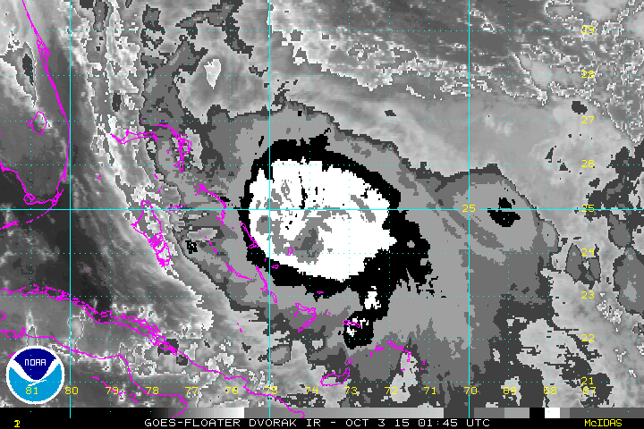
Before the plane left the storm, it recorded the highest flight level winds (2:45:30Z; 30s: 128 knots; 10s: 130 knots) and approximately the highest surface winds from a sonde (2:46:37Z; Momentary gust 1 millibar above surface: 122 knots) of any mission so far.
Satellite at the time the storm had the highest flight level winds of any mission (on the second pass in the SE quadrant in that intense convection):

And five hours later:

This storm has constantly amazed with high wind speeds despite an often ragged appearance. With an improving appearance, who knows. We'll have to see what they find when the next plane does a center fix around 7:30am EDT.
I really wish they were still doing NOAA G-IV missions. Bermuda needs to be watching this storm very carefully.
From a blog post from NOAA HRD on Friday (https://noaahrd.wordpress.com/):
"G-IV: Was scheduled to fly an NHC operationally tasked synoptic surveillance mission. This flight and all future flights G-IV flights for Joaquin has been cancelled."
Saved RBTOP loop:
http://i.imgur.com/fvGn3qh.webm
Saved AVN loop:
http://i.imgur.com/dEEtGjl.gifv
(00:45 to 7:45Z)
0 likes
-
hurricaneCW
- Category 5
- Posts: 1799
- Joined: Wed Mar 03, 2010 6:20 am
- Location: Toms River, NJ
Re: ATL: JOAQUIN - Hurricane - Discussion
It does not look good for Bermuda, Joaquin might roll right over or very close to them based on its projected path. NHC's 5am track will probably bring him just west or over the island.
0 likes
-
Chris_in_Tampa
- Category 5
- Posts: 5101
- Age: 42
- Joined: Thu Jun 21, 2007 11:06 pm
- Location: Tampa, Florida, USA
- Contact:
From the 5am NHC discussion:
"Overall, the convective pattern is similar
to what it was when the previous aircraft indicated the intensity
was around 110 kt, so that will remain the intensity for this
advisory."
The NHC has done very good in their discussions of this storm, some of the best discussions on uncertainty that they have ever done, but that sentence is off. The storm has changed significantly since then.
Saved AVN loop:
http://imgur.com/k9aRWPw
Saved RBTOP loop:
http://imgur.com/gVzLGhk
0 likes
Maybe the NHC is waiting for recon data, but I have to say Joaquin is reorganizing. Expect recon to find a stronger storm.
0 likes
Personal Forecast Disclaimer:
The posts in this forum are NOT official forecast and should not be used as such. They are just the opinion of the poster and may or may not be backed by sound meteorological data. They are NOT endorsed by any professional institution or storm2k.org. For official information, please refer to RSMC and NWS products.
The posts in this forum are NOT official forecast and should not be used as such. They are just the opinion of the poster and may or may not be backed by sound meteorological data. They are NOT endorsed by any professional institution or storm2k.org. For official information, please refer to RSMC and NWS products.
Re: ATL: JOAQUIN - Hurricane - Discussion
Chris_in_Tampa wrote:I really wish they were still doing NOAA G-IV missions. Bermuda needs to be watching this storm very carefully.
From a blog post from NOAA HRD on Friday (https://noaahrd.wordpress.com/):
"G-IV: Was scheduled to fly an NHC operationally tasked synoptic surveillance mission. This flight and all future flights G-IV flights for Joaquin has been cancelled."
As far as I know (I could be wrong) they only do the flights if the storm poses a potential risk to the US, so they may have cancelled it on that basis as it's headed away.
0 likes
The above post is not official and should not be used as such. It is the opinion of the poster and may or may not be backed by sound meteorological data. It is not endorsed by any professional institution or storm2k.org. For official information, please refer to the NHC and NWS products.
-
Chris_in_Tampa
- Category 5
- Posts: 5101
- Age: 42
- Joined: Thu Jun 21, 2007 11:06 pm
- Location: Tampa, Florida, USA
- Contact:
Re: ATL: JOAQUIN - Hurricane - Discussion
I was just reading the CPHC discussion on TD Seven-C and the NOAA G-IV is going to head out there to sample around that developing storm that is forecast to be a hurricane near Hawaii.Hammy wrote:As far as I know (I could be wrong) they only do the flights if the storm poses a potential risk to the US, so they may have cancelled it on that basis as it's headed away.
The Air Force hurricane hunters are back on the way to Joaquin. They took off from Savannah, GA a bit before 5am EDT. They should be at the center by about 7:30am EDT based on the schedule.
As long as Joaquin is threatening Bermuda, recon will continue. They are scheduled to continue 6 hour fixes through Sunday night.
NHC Plan of the Day:
http://www.nhc.noaa.gov/recon.php
And just to add, they were doing two G-IV missions a day due to the risk at the time of a U.S. hit from Joaquin, but they would sample around for other countries too.
0 likes

Re: ATL: JOAQUIN - Hurricane - Discussion
Cuba and the Florida peninsula may have dried out the inflow temporarily, Joaquin seems to be recovering this morning.
The ULL north of Joaquin looks like it might be filling in. If pressures rise north of the system shear will be reduced and Joaquin may stay strong longer. Hard to tell but high pressure may eventually bridge over and keep the track west of Bermuda.
The ULL north of Joaquin looks like it might be filling in. If pressures rise north of the system shear will be reduced and Joaquin may stay strong longer. Hard to tell but high pressure may eventually bridge over and keep the track west of Bermuda.
0 likes
-
Chris_in_Tampa
- Category 5
- Posts: 5101
- Age: 42
- Joined: Thu Jun 21, 2007 11:06 pm
- Location: Tampa, Florida, USA
- Contact:

-
Chris_in_Tampa
- Category 5
- Posts: 5101
- Age: 42
- Joined: Thu Jun 21, 2007 11:06 pm
- Location: Tampa, Florida, USA
- Contact:
Recon as of 6:02am EDT. I'll post only occasionally until they gets closer.

Wide view. Recon as of 6:12am EDT. 5am EDT water vapor satellite image from SSEC. (https://realearth.ssec.wisc.edu/)

Wide view. Recon as of 6:12am EDT. 5am EDT water vapor satellite image from SSEC. (https://realearth.ssec.wisc.edu/)
0 likes

Re: ATL: JOAQUIN - Hurricane - Discussion
Chris_in_Tampa wrote:Before the plane left the storm, it recorded the highest flight level winds (2:45:30Z; 30s: 128 knots; 10s: 130 knots) and approximately the highest surface winds from a sonde (2:46:37Z; Momentary gust 1 millibar above surface: 122 knots) of any mission so far.
Satellite at the time the storm had the highest flight level winds of any mission (on the second pass in the SE quadrant in that intense convection):
And five hours later:
This storm has constantly amazed with high wind speeds despite an often ragged appearance. With an improving appearance, who knows. We'll have to see what they find when the next plane does a center fix around 7:30am EDT.
I really wish they were still doing NOAA G-IV missions. Bermuda needs to be watching this storm very carefully.
From a blog post from NOAA HRD on Friday (https://noaahrd.wordpress.com/):
"G-IV: Was scheduled to fly an NHC operationally tasked synoptic surveillance mission. This flight and all future flights G-IV flights for Joaquin has been cancelled."
Saved RBTOP loop:
http://i.imgur.com/fvGn3qh.webm
Saved AVN loop:
http://i.imgur.com/dEEtGjl.gifv
(00:45 to 7:45Z)
It just keeps getting better looking. Interesting recon flight.

0 likes
Re: ATL: JOAQUIN - Hurricane - Discussion
The obligatory WV loop. Looks like the Atlantic ULL has been working its way down to the surface and is scooting NW. SC is going to go under water with that fire hose.

0 likes
Forecast Disclaimer:
The posts in this forum are NOT official forecast and should not be used as such. They are just the opinion of the poster and may or may not be backed by sound meteorological data. They are NOT endorsed by any professional institution or storm2k.org. For official information, please refer to the NHC and NWS products.
The posts in this forum are NOT official forecast and should not be used as such. They are just the opinion of the poster and may or may not be backed by sound meteorological data. They are NOT endorsed by any professional institution or storm2k.org. For official information, please refer to the NHC and NWS products.
-
Chris_in_Tampa
- Category 5
- Posts: 5101
- Age: 42
- Joined: Thu Jun 21, 2007 11:06 pm
- Location: Tampa, Florida, USA
- Contact:
Re: ATL: JOAQUIN - Recon
Recon as of 7:02am EDT:


Last edited by Chris_in_Tampa on Sat Oct 03, 2015 6:15 am, edited 1 time in total.
0 likes
-
Chris_in_Tampa
- Category 5
- Posts: 5101
- Age: 42
- Joined: Thu Jun 21, 2007 11:06 pm
- Location: Tampa, Florida, USA
- Contact:

-
Chris_in_Tampa
- Category 5
- Posts: 5101
- Age: 42
- Joined: Thu Jun 21, 2007 11:06 pm
- Location: Tampa, Florida, USA
- Contact:
Re: ATL: JOAQUIN - Recon
URNT15 KNHC 031121
AF304 1311A JOAQUIN HDOB 16 20151003
111230 2609N 07319W 6967 03022 9894 +098 +078 045043 044 030 001 00
111300 2608N 07317W 6976 03011 9898 +093 +081 044044 044 031 000 00
111330 2606N 07316W 6976 03008 9894 +095 +072 048044 045 032 000 00
111400 2605N 07315W 6955 03025 9894 +089 +078 043046 047 034 001 00
111430 2603N 07314W 6977 02995 9889 +092 //// 039046 047 037 001 01
111500 2602N 07312W 6967 03009 9900 +101 //// 048048 050 036 004 01
111530 2600N 07311W 6959 03009 //// +088 //// 051049 050 037 003 01
111600 2559N 07310W 6970 02990 //// +089 //// 048051 052 039 001 01
111630 2558N 07309W 6970 02987 //// +093 //// 047053 055 039 002 01
111700 2556N 07308W 6969 02983 //// +096 //// 044057 057 042 001 01
111730 2555N 07306W 6970 02971 //// +094 //// 039058 059 048 005 01
111800 2553N 07305W 6967 02967 9842 +103 +103 034059 061 049 008 00
111830 2552N 07304W 6969 02955 9839 +109 +109 028059 060 053 009 00
111900 2550N 07303W 6968 02948 9825 +112 +112 027060 062 055 012 00
111930 2549N 07301W 6972 02937 9823 +109 //// 032059 060 060 006 01
112000 2547N 07300W 6967 02930 9796 +104 //// 036059 060 063 004 01
112030 2546N 07259W 6970 02916 9784 +111 //// 040058 060 063 005 01
112100 2544N 07258W 6966 02910 9746 +122 //// 040060 062 064 007 01
112130 2543N 07256W 6970 02892 9730 +129 //// 041064 065 065 006 01
112200 2541N 07255W 6968 02878 9714 +133 +133 036066 067 067 015 00
Flight Level Wind (30 sec. Avg.): 66 knots
Peak (10 sec. Avg.) Flight Level Wind: 67 knots
SFMR Peak (10s Avg.) Sfc. Wind: 67 knots
0 likes
-
Chris_in_Tampa
- Category 5
- Posts: 5101
- Age: 42
- Joined: Thu Jun 21, 2007 11:06 pm
- Location: Tampa, Florida, USA
- Contact:
URNT15 KNHC 031132
AF304 1311A JOAQUIN HDOB 17 20151003
112230 2540N 07254W 6971 02852 9712 +123 +123 031076 078 070 015 00
112300 2538N 07252W 6963 02841 9681 +134 +134 034075 078 076 009 00
112330 2537N 07251W 6966 02815 9624 +141 +140 032083 084 078 007 00
112400 2535N 07250W 6970 02785 9589 +144 +138 033085 086 082 004 00
112430 2534N 07249W 6974 02758 9541 +160 +136 036083 086 082 000 00
112500 2532N 07247W 6959 02738 9513 +156 +124 039082 084 082 000 00
112530 2531N 07246W 6976 02680 //// +144 //// 037076 081 079 001 05
112600 2530N 07245W 6966 02667 9446 +150 +146 035048 069 062 004 01
112630 2529N 07243W 6972 02646 9435 +148 +143 033030 040 040 002 00
112700 2528N 07241W 6967 02644 9428 +143 +143 027020 024 028 001 01
112730 2527N 07240W 6967 02635 //// +141 //// 009012 019 024 001 05
112800 2526N 07238W 6972 02624 //// +145 //// 352007 010 022 001 01
112830 2526N 07236W 6971 02618 //// +145 //// 280006 009 023 000 01
112900 2526N 07234W 6968 02618 9394 +148 +142 249010 012 022 002 05
112930 2525N 07232W 6963 02620 9398 +146 +143 235017 021 022 001 00
113000 2524N 07230W 6967 02616 9397 +149 +144 224028 032 028 001 00
113030 2522N 07229W 6967 02620 //// +141 //// 224043 047 042 003 01
113100 2521N 07228W 6973 02624 9427 +148 //// 223054 057 082 010 01
113130 2520N 07226W 6978 02631 9442 +155 +155 224070 080 100 011 00
113200 2519N 07225W 6960 02672 9486 +147 +147 227104 120 097 023 00
Flight Level Wind (30 sec. Avg.): 104 knots
Peak (10 sec. Avg.) Flight Level Wind: 120 knots
SFMR Peak (10s Avg.) Sfc. Wind: 100 knots
Extrapolated Sfc. Pressure: 939.4 mb
Huge difference between 30s and 10s flight level wind.
0 likes
-
Chris_in_Tampa
- Category 5
- Posts: 5101
- Age: 42
- Joined: Thu Jun 21, 2007 11:06 pm
- Location: Tampa, Florida, USA
- Contact:
-
Chris_in_Tampa
- Category 5
- Posts: 5101
- Age: 42
- Joined: Thu Jun 21, 2007 11:06 pm
- Location: Tampa, Florida, USA
- Contact:

-
ninel conde
Who is online
Users browsing this forum: No registered users and 14 guests