ATL: JOAQUIN - Post-Tropical - Discussion
Moderator: S2k Moderators
-
1900hurricane

- Category 5

- Posts: 6063
- Age: 34
- Joined: Fri Feb 06, 2015 12:04 pm
- Location: Houston, TX
- Contact:
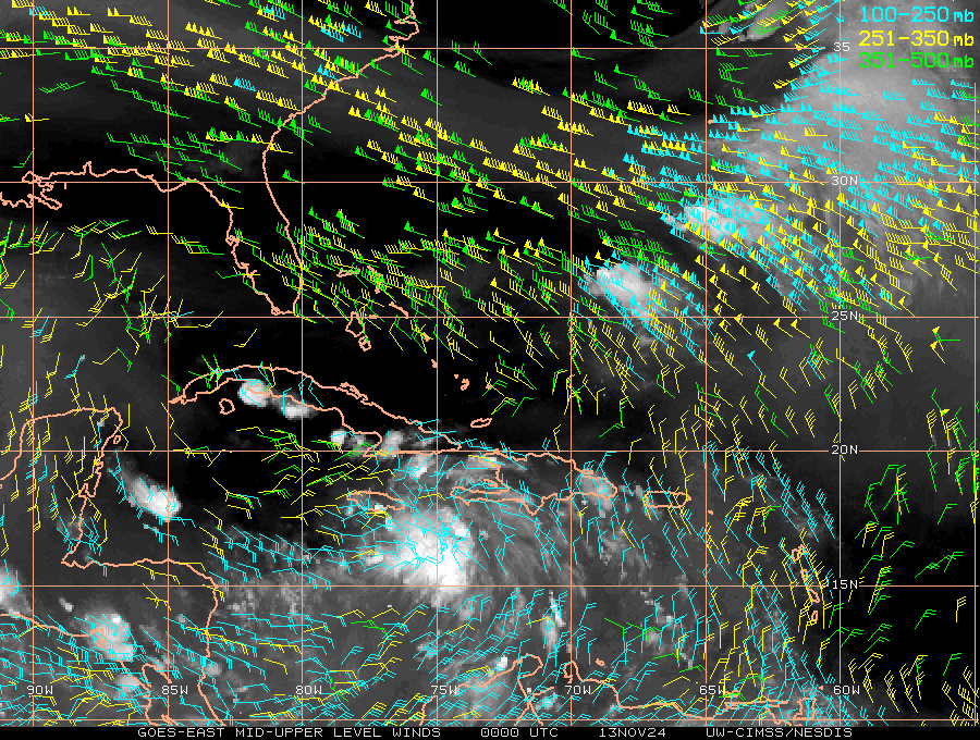
Looks like the poleward outflow channel is about ready to open up.
0 likes
Contract Meteorologist. TAMU & MSST. Fiercely authentic, one of a kind. We are all given free will, so choose a life meant to be lived. We are the Masters of our own Stories.
Opinions expressed are mine alone.
Follow me on Twitter at @1900hurricane : Read blogs at https://1900hurricane.wordpress.com/
Opinions expressed are mine alone.
Follow me on Twitter at @1900hurricane : Read blogs at https://1900hurricane.wordpress.com/
-
AutoPenalti
- Category 5
- Posts: 4091
- Age: 29
- Joined: Mon Aug 17, 2015 4:16 pm
- Location: Ft. Lauderdale, Florida
Re:
1900hurricane wrote:Looks like the poleward outflow channel is about ready to open up.
http://tropic.ssec.wisc.edu/real-time/a ... 8wvirZ.GIF
Where do you see that?
Last edited by AutoPenalti on Thu Oct 01, 2015 9:32 pm, edited 1 time in total.
0 likes
The posts in this forum are NOT official forecasts and should not be used as such. They are just the opinion of the poster and may or may not be backed by sound meteorological data. They are NOT endorsed by any professional institution or STORM2K. For official information, please refer to products from the NHC and NWS.
Model Runs Cheat Sheet:
GFS (5:30 AM/PM, 11:30 AM/PM)
HWRF, GFDL, UKMET, NAVGEM (6:30-8:00 AM/PM, 12:30-2:00 AM/PM)
ECMWF (1:45 AM/PM)
TCVN is a weighted averaged
-
Chris_in_Tampa
- Category 5
- Posts: 5101
- Age: 42
- Joined: Thu Jun 21, 2007 11:06 pm
- Location: Tampa, Florida, USA
- Contact:


Re: Re:
wxman57 wrote:gatorcane wrote:Looking at this WV loop, what is that spin I see directly NE of Joaquin in the orange area heading SW?
Is that a small Upper-Level low that has developed as I don't see where the models are showing it.
Could this feature have any impact on Joaquin and future path?
http://i.imgur.com/ec9W6cW.gif
That is a small upper-level low you're seeing. I believe it's the feature that the models have had interacting with Joaquin by weakening the western edge of the ridge that's blocking Joaquin from moving north then northeast. It's why the models shifted to the east today. Of course, the 18z GFS ensembles still had a number of east coast hits, more than 12z. The threat isn't over for the east coast yet.
I was wondering what that was as well. Thanks Wxman57 and Gatorcane for bringing that up.
As for the path, I worry a little because some big media outlets have picked up on the fish possibility and seem to be writing Joaquin off. I hope it goes out to sea, but I worry when I see articles stating it most likely will follow that path when we really don't know yet. If I were reporting on this, I would rather err on the side of caution. Don't want to spread panic, but they should let people know nothing is set in stone yet.
0 likes
The following post is NOT an official forecast and should not be used as such. It is just the opinion of the poster and may or may not be backed by sound meteorological data. It is NOT endorsed by any professional institution including storm2k.org. For Official Information please refer to the NHC and NWS products.
-
ozonepete
- Professional-Met

- Posts: 4743
- Joined: Mon Sep 07, 2009 3:23 pm
- Location: From Ozone Park, NYC / Now in Brooklyn, NY
Re: Re:
bjackrian wrote:ozonepete wrote:spiral wrote:http://i60.tinypic.com/331orys.jpg
Bath waters.
It's the depth of the warm water that matters, not the surface temp. If surface temp is 90F and 10 meters down it's 75F, a tropical cyclone not moving fast will quickly pull up the 75F water and die out.
Is that true even for shallow water (i.e., if the water is 50 m deep and is >26C for all 50m is that different from the water being 500 m deep with a 50m 26C level)?
Great question. There is no difference between your two cases, since in the second case, where it's 500 meters deep but only the first 50m is 26C, we know that the water below that first 50 meters has to be colder than 26C since water temp gets colder as you go deeper, generally speaking.
0 likes
-
ozonepete
- Professional-Met
- Posts: 4743
- Joined: Mon Sep 07, 2009 3:23 pm
- Location: From Ozone Park, NYC / Now in Brooklyn, NY
Re: ATL: JOAQUIN - Hurricane - Discussion
green eyed girl wrote:ozonepete wrote:GlennOBX wrote:Excuse the simple question, but with the talk about whether or not this gets west of 75°W and whether the models had predicted that it would, does anything change regarding the consensus forecast if Joaquin does get past 75° W?
Thanks
If Joaquin gets further past 75 W there is a better chance it will not turn north as soon and the Midwestern trough will catch it and keep it closer to the coast. In that case the models will shift west again.
Ozone, in your opinion, is this something you think may happen? Or not likely?
Not that likely but there's a 50/50 chance in my opinion. We need to wait. I am pretty sure the track will be obvious by Saturday but probably not before.
0 likes
-
Chris_in_Tampa
- Category 5
- Posts: 5101
- Age: 42
- Joined: Thu Jun 21, 2007 11:06 pm
- Location: Tampa, Florida, USA
- Contact:
That invalid SFMR reading, which was suspect, was a few hundred yards from shore of Mayaguana Island in what would be extremely shallow water.
Speaking of SFMR, I just heard that all SFMR wind values in HDOB messages are now bias corrected in real time.
You can download an early version of the paper about it here that is
available free:
http://www.researchgate.net/publication ... cipitation
Or if you have access, here is the final version:
http://journals.ametsoc.org/doi/abs/10. ... 14-00028.1
Power Point presentation:
http://www.ofcm.gov/ihc15/presentations ... 4a-03.pptx
All the SFMR processors have now been updated and the correction occurs in real time and exists in the HDOB messages that now go out. I don't know exactly when the change occurred.
0 likes
-
CrazyC83
- Professional-Met
- Posts: 34315
- Joined: Tue Mar 07, 2006 11:57 pm
- Location: Deep South, for the first time!
000
URNT15 KNHC 020219
AF300 0911A JOAQUIN HDOB 43 20151002
021030 2340N 07303W 6969 03089 9981 +097 +028 157053 055 034 002 03
021100 2342N 07303W 6956 03103 9977 +099 +029 155053 054 033 001 03
021130 2344N 07303W 6964 03094 9980 +098 +031 154052 054 033 001 03
021200 2347N 07303W 6967 03092 9984 +097 +024 151051 052 034 001 00
021230 2349N 07303W 6971 03089 9985 +098 +027 149050 052 035 001 03
021300 2351N 07303W 6964 03096 9986 +095 +032 141047 048 030 001 03
021330 2353N 07303W 6964 03101 9993 +091 +036 139047 048 033 001 03
021400 2355N 07303W 6967 03096 9999 +087 +044 138046 047 033 002 03
021430 2357N 07303W 6968 03097 0004 +082 +044 138046 047 030 002 00
021500 2359N 07303W 6968 03097 9998 +087 +049 136045 046 029 002 03
021530 2401N 07303W 6968 03098 9997 +090 +046 137047 047 030 002 00
021600 2403N 07303W 6966 03101 9995 +092 +038 138047 048 027 002 00
021630 2405N 07303W 6970 03096 9993 +094 +031 140047 048 028 001 00
021700 2407N 07303W 6967 03103 0000 +088 +033 140049 049 027 002 03
021730 2409N 07303W 6967 03101 0003 +086 +039 139050 051 027 001 03
021800 2411N 07303W 6968 03098 0001 +089 +044 141051 052 023 002 03
021830 2413N 07303W 6968 03099 0006 +084 +044 141050 051 023 001 00
021900 2415N 07302W 6972 03106 0006 +089 +054 143052 053 024 002 03
021930 2416N 07301W 6963 03110 0005 +090 +038 146048 050 023 002 00
022000 2416N 07259W 6971 03099 0002 +093 +027 145047 049 023 002 00
$$
;
0 likes

-
p1nheadlarry

- Category 2

- Posts: 672
- Age: 34
- Joined: Wed Jan 29, 2014 2:42 pm
- Location: SR County FL
Re: ATL: JOAQUIN - Hurricane - Discussion
OuterBanker wrote:I'm heading home tomorrow. Already a real mess on the OBX and it's going to get a lot worse over the next three days. Ocracoke has already been evacuated and none of has to do with Joaquin. Relying on it going out to sea. Can't even imagine what would happen if it came closer.
It's going to be a wet weekend, maybe one for the record books, regardless of how much moisture Joaquin contributes to it. I hope the forecast for SC isn't as dire as I've seen, locally up to 1.5 feet in spots...sheesh.
0 likes
--;->#GoNoles--;->.
-
CrazyC83
- Professional-Met
- Posts: 34315
- Joined: Tue Mar 07, 2006 11:57 pm
- Location: Deep South, for the first time!
000
URNT15 KNHC 020229
AF300 0911A JOAQUIN HDOB 44 20151002
022030 2416N 07257W 6967 03108 0005 +091 +024 146048 049 023 002 03
022100 2416N 07255W 6968 03107 0002 +095 +024 146048 049 023 001 00
022130 2416N 07254W 6967 03109 0001 +098 +019 146046 048 024 001 03
022200 2416N 07252W 6969 03108 0010 +092 +025 146045 048 /// /// 03
022230 2414N 07253W 6966 03113 0016 +085 +025 140044 044 /// /// 03
022300 2414N 07255W 6967 03104 0010 +086 +027 137045 046 018 001 00
022330 2413N 07257W 6967 03105 0007 +086 +035 140045 046 020 002 03
022400 2412N 07259W 6967 03102 0003 +089 +047 140044 045 021 001 03
022430 2412N 07300W 6964 03105 0000 +090 +044 139043 044 021 001 00
022500 2411N 07302W 6966 03101 0001 +089 +040 138043 044 021 002 03
022530 2410N 07304W 6965 03103 0000 +090 +042 139043 044 022 002 03
022600 2409N 07305W 6967 03100 0000 +090 +044 141044 045 025 001 03
022630 2407N 07307W 6967 03099 9997 +090 +044 136043 044 027 001 03
022700 2406N 07308W 6966 03102 9997 +090 +043 133042 043 026 002 03
022730 2405N 07309W 6966 03100 9997 +090 +044 130042 043 028 000 03
022800 2404N 07311W 6967 03101 9998 +087 +046 133042 043 029 001 03
022830 2402N 07312W 6969 03095 9998 +087 +041 134043 044 030 001 00
022900 2401N 07313W 6963 03103 9994 +091 +037 133044 045 030 001 03
022930 2400N 07315W 6974 03087 9990 +095 +035 138047 048 031 001 03
023000 2359N 07316W 6962 03104 9984 +097 +031 143048 050 028 001 03
$$
;
0 likes
-
deltadog03

- Professional-Met
- Posts: 3580
- Joined: Tue Jul 05, 2005 6:16 pm
- Location: Macon, GA


Re: ATL: JOAQUIN - Hurricane - Discussion
p1nheadlarry wrote:It's going to be a wet weekend, maybe one for the record books, regardless of how much moisture Joaquin contributes to it. I hope the forecast for SC isn't as dire as I've seen, locally up to 1.5 feet in spots...sheesh.
All of SC is in a Flash Flood Watch for good reason. A few of the school districts are in discussion about closing early due to the possibility of late day rains on soaked roads. Many buses in the rural areas travel on dirt (clay) roads that are very slick.
Still... Nothing like the folks in the Bahamas.
0 likes

Re:
deltadog03 wrote:
For a novice, deltadog do those maps show the steering pattern to support the Euro model and avoid a landfall hit?
0 likes
Disclaimer:
My posts in this forum are NOT official forecast and should not be used as such. They are of my opinion and as such should NOT be treated as an official forecast. For official information, please refer to the NHC and NWS products.
My posts in this forum are NOT official forecast and should not be used as such. They are of my opinion and as such should NOT be treated as an official forecast. For official information, please refer to the NHC and NWS products.
-
Chris_in_Tampa
- Category 5
- Posts: 5101
- Age: 42
- Joined: Thu Jun 21, 2007 11:06 pm
- Location: Tampa, Florida, USA
- Contact:

-
1900hurricane
- Category 5
- Posts: 6063
- Age: 34
- Joined: Fri Feb 06, 2015 12:04 pm
- Location: Houston, TX
- Contact:
Re: Re:
AutoPenalti wrote:1900hurricane wrote:Looks like the poleward outflow channel is about ready to open up.
http://tropic.ssec.wisc.edu/real-time/a ... 8wvirZ.GIF
Where do you see that?
With the jet streak exiting the incoming trough. It doesn't quite connect to Joaquin's outflow yet, but it should before too long. That'll be a good avenue to suck mass out of the top of the storm.
0 likes
Contract Meteorologist. TAMU & MSST. Fiercely authentic, one of a kind. We are all given free will, so choose a life meant to be lived. We are the Masters of our own Stories.
Opinions expressed are mine alone.
Follow me on Twitter at @1900hurricane : Read blogs at https://1900hurricane.wordpress.com/
Opinions expressed are mine alone.
Follow me on Twitter at @1900hurricane : Read blogs at https://1900hurricane.wordpress.com/
-
deltadog03
- Professional-Met
- Posts: 3580
- Joined: Tue Jul 05, 2005 6:16 pm
- Location: Macon, GA
Re:
deltadog03 wrote:yes it shows a path to exit out. The jet over the SE should align over the next 24 hours to provide EXCELLENT poleward outflow channel. I think he has 1 last shot (by this time tomorrow) to hit stronger cat 4 or maybe a brief 5
Thanks for the explanation.
0 likes
Disclaimer:
My posts in this forum are NOT official forecast and should not be used as such. They are of my opinion and as such should NOT be treated as an official forecast. For official information, please refer to the NHC and NWS products.
My posts in this forum are NOT official forecast and should not be used as such. They are of my opinion and as such should NOT be treated as an official forecast. For official information, please refer to the NHC and NWS products.
-
CrazyC83
- Professional-Met
- Posts: 34315
- Joined: Tue Mar 07, 2006 11:57 pm
- Location: Deep South, for the first time!
URNT15 KNHC 020239
AF300 0911A JOAQUIN HDOB 45 20151002
023030 2358N 07317W 6964 03095 9979 +100 +029 142049 050 030 001 03
023100 2356N 07319W 6968 03090 9973 +103 +027 143051 052 030 001 03
023130 2355N 07320W 6967 03090 9967 +106 +026 143050 050 031 000 00
023200 2354N 07321W 6963 03089 9961 +109 +027 140050 050 029 002 00
023230 2353N 07323W 6966 03085 9960 +109 +023 138050 051 030 002 03
023300 2352N 07324W 6969 03081 9949 +117 +019 136051 051 031 002 00
023330 2350N 07325W 6965 03084 9945 +118 +018 134050 051 029 001 03
023400 2349N 07327W 6970 03080 9942 +119 +018 135050 052 029 001 03
023430 2348N 07328W 6963 03083 9958 +103 +029 137052 052 028 002 00
023500 2347N 07329W 6969 03073 9956 +102 +039 136052 053 029 001 00
023530 2346N 07331W 6968 03071 9951 +104 +042 139051 051 030 001 00
023600 2344N 07332W 6962 03077 9953 +101 +037 141048 052 031 000 00
023630 2343N 07333W 6964 03073 9949 +101 +040 140045 047 031 002 00
023700 2342N 07335W 6970 03063 9941 +106 +033 145050 051 031 001 03
023730 2341N 07336W 6965 03064 9936 +109 +035 144052 054 033 002 00
023800 2340N 07337W 6971 03057 9929 +112 +035 146054 056 037 002 00
023830 2338N 07339W 6960 03066 9931 +105 +038 150056 057 037 002 03
023900 2337N 07340W 6962 03060 9937 +097 +040 153056 057 036 003 03
023930 2336N 07341W 6963 03057 9933 +101 +040 149053 055 036 002 00
024000 2335N 07342W 6977 03039 9924 +108 +040 145061 066 038 001 00
$$
;
0 likes
-
gatorcane

- S2K Supporter

- Posts: 23708
- Age: 48
- Joined: Sun Mar 13, 2005 3:54 pm
- Location: Boca Raton, FL
Joaquin is morphing into a strange shape, looks like the top of the storm is getting flattened while the west side is expanding out. 
http://rammb.cira.colostate.edu/ramsdis ... display=12
http://rammb.cira.colostate.edu/ramsdis ... display=12
0 likes
Who is online
Users browsing this forum: No registered users and 70 guests