ATL: JOAQUIN - Post-Tropical - Discussion
Moderator: S2k Moderators
-
Extratropical94

- Professional-Met

- Posts: 3545
- Age: 31
- Joined: Wed Oct 20, 2010 6:36 am
- Location: Hamburg, Germany
- Contact:

0 likes
54° 11' 59'' N, 9° 9' 20'' E
Boomer Sooner!
Go Broncos! Go Cards!
Clinching counties, one at a time: https://mob-rule.com/user-gifs/USA/xtrp94.gif
- Daniel
Boomer Sooner!
Go Broncos! Go Cards!
Clinching counties, one at a time: https://mob-rule.com/user-gifs/USA/xtrp94.gif
- Daniel
-
emeraldislenc
- Category 2

- Posts: 601
- Joined: Fri Aug 24, 2012 4:49 pm
- Location: Emerald Isle NC
Re: ATL: JOAQUIN - Hurricane - Discussion
What are the thoughts of a more west track at 11 am?
0 likes
-
CrazyC83
- Professional-Met
- Posts: 34315
- Joined: Tue Mar 07, 2006 11:57 pm
- Location: Deep South, for the first time!
000
URNT15 KNHC 301246
AF300 0311A JOAQUIN HDOB 36 20150930
123730 2421N 07248W 6957 03063 9948 +083 +063 323054 062 047 018 00
123800 2420N 07249W 6976 03044 9955 +081 +067 317051 053 045 019 03
123830 2419N 07250W 6964 03062 9954 +085 +064 313051 053 041 014 03
123900 2417N 07252W 6961 03068 9964 +081 +058 316052 053 042 012 00
123930 2416N 07253W 6972 03061 9963 +087 +049 315050 052 045 006 00
124000 2415N 07254W 6960 03078 9970 +083 +053 314051 053 045 015 03
124030 2414N 07256W 6967 03072 9979 +077 +062 306055 056 037 031 00
124100 2413N 07257W 6949 03091 9991 +069 +068 300052 053 038 023 00
124130 2411N 07258W 6954 03094 9998 +069 +065 301052 052 035 016 00
124200 2410N 07259W 6969 03076 0002 +066 +047 305053 054 035 010 00
124230 2409N 07301W 6962 03090 9992 +078 +042 306054 054 039 006 00
124300 2408N 07302W 6963 03089 9981 +089 +042 310052 054 038 004 00
124330 2407N 07303W 6963 03093 9980 +093 +039 310052 053 037 003 00
124400 2406N 07305W 6963 03095 9982 +094 +040 314052 053 035 003 00
124430 2404N 07306W 6965 03095 9989 +090 +044 313050 051 035 003 00
124500 2403N 07307W 6966 03095 9989 +090 +045 311049 050 034 002 00
124530 2402N 07309W 6962 03101 9993 +090 +043 313049 050 033 002 00
124600 2401N 07310W 6965 03098 9994 +090 +044 313050 050 030 002 00
124630 2359N 07311W 6967 03097 9996 +089 +043 313052 053 032 001 00
124700 2358N 07313W 6965 03102 9999 +090 +036 312053 053 033 002 00
$$
;
0 likes
-
CrazyC83
- Professional-Met
- Posts: 34315
- Joined: Tue Mar 07, 2006 11:57 pm
- Location: Deep South, for the first time!
000
URNT12 KNHC 301247
VORTEX DATA MESSAGE AL112015
A. 30/12:26:30Z
B. 24 deg 50 min N
072 deg 18 min W
C. 700 mb 2859 m
D. 66 kt
E. 042 deg 21 nm
F. 117 deg 74 kt
G. 043 deg 25 nm
H. 972 mb
I. 11 C / 3052 m
J. 16 C / 3052 m
K. 4 C / NA
L. CLOSED
M. C48
N. 12345 / 07
O. 0.02 / 2.5 nm
P. AF300 0311A JOAQUIN OB 17
MAX OUTBOUND AND MAX FL WIND 83 KT 225 / 18 NM 12:31:30Z
CNTR DROPSONDE SFC WIND 065 / 9 KT
;
0 likes

Re: ATL: JOAQUIN - Hurricane - Discussion
Funny enough that's the name of my son! appears to not be coming this way thankfully.
0 likes
-
Yellow Evan

- Professional-Met
- Posts: 16232
- Age: 27
- Joined: Fri Jul 15, 2011 12:48 pm
- Location: Henderson, Nevada/Honolulu, HI
- Contact:
-
tropicwatch

- Category 5

- Posts: 3426
- Age: 62
- Joined: Sat Jun 02, 2007 10:01 am
- Location: Panama City Florida
- Contact:
Re: ATL: JOAQUIN - Hurricane - Discussion
tgenius wrote:Funny enough that's the name of my son! appears to not be coming this way thankfully.
Its only about 500miles ese of Miami currently.
0 likes
Tropicwatch
Agnes 72', Eloise 75, Elena 85', Kate 85', Charley 86', Florence 88', Beryl 94', Dean 95', Erin 95', Opal 95', Earl 98', Georges 98', Ivan 2004', Arlene 2005', Dennis 2005', Ida 2009' Debby 2012' Irma 2017' Michael 2018'
Agnes 72', Eloise 75, Elena 85', Kate 85', Charley 86', Florence 88', Beryl 94', Dean 95', Erin 95', Opal 95', Earl 98', Georges 98', Ivan 2004', Arlene 2005', Dennis 2005', Ida 2009' Debby 2012' Irma 2017' Michael 2018'
-
Yellow Evan
- Professional-Met
- Posts: 16232
- Age: 27
- Joined: Fri Jul 15, 2011 12:48 pm
- Location: Henderson, Nevada/Honolulu, HI
- Contact:

I guess having the track pointed directly at me at this point is a good thing, 0% the track doesn't change in 6 days lol 
0 likes
Andrew '92 Opal '95 Blizzard '96 Izzy '03 Irene '11 Sandy '12
The following post is NOT an official forecast and should not be used as such. It is just the opinion is not be backed by sound meteorological data. It is NOT endorsed by any professional institution including storm2k.org For Official Information please refer to the NHC and NWS products.
The following post is NOT an official forecast and should not be used as such. It is just the opinion is not be backed by sound meteorological data. It is NOT endorsed by any professional institution including storm2k.org For Official Information please refer to the NHC and NWS products.
-
summersquall

- Tropical Storm

- Posts: 230
- Joined: Wed Jun 16, 2010 11:23 am
- Location: Jensen Beach FL 27°N 80°W (roughly)

0 likes
My posts should NEVER, EVER, EVER be construed as an official forecast as I know virtually nada respecting the finer points of meteorology. Consequently, my posts are obviously NOT endorsed by any professional institution or the good folks at storm2k.org. For official information please refer to the weather gurus at the NHC and NWS.
-
AutoPenalti
- Category 5
- Posts: 4091
- Age: 29
- Joined: Mon Aug 17, 2015 4:16 pm
- Location: Ft. Lauderdale, Florida
My eyes are telling me that it's finally moving W, instead of SW. That or it's probably an illusion.
0 likes
The posts in this forum are NOT official forecasts and should not be used as such. They are just the opinion of the poster and may or may not be backed by sound meteorological data. They are NOT endorsed by any professional institution or STORM2K. For official information, please refer to products from the NHC and NWS.
Model Runs Cheat Sheet:
GFS (5:30 AM/PM, 11:30 AM/PM)
HWRF, GFDL, UKMET, NAVGEM (6:30-8:00 AM/PM, 12:30-2:00 AM/PM)
ECMWF (1:45 AM/PM)
TCVN is a weighted averaged
-
tropicwatch
- Category 5
- Posts: 3426
- Age: 62
- Joined: Sat Jun 02, 2007 10:01 am
- Location: Panama City Florida
- Contact:
Well if it gets a well defined eye, direction of travel should be easier to see.
0 likes
Tropicwatch
Agnes 72', Eloise 75, Elena 85', Kate 85', Charley 86', Florence 88', Beryl 94', Dean 95', Erin 95', Opal 95', Earl 98', Georges 98', Ivan 2004', Arlene 2005', Dennis 2005', Ida 2009' Debby 2012' Irma 2017' Michael 2018'
Agnes 72', Eloise 75, Elena 85', Kate 85', Charley 86', Florence 88', Beryl 94', Dean 95', Erin 95', Opal 95', Earl 98', Georges 98', Ivan 2004', Arlene 2005', Dennis 2005', Ida 2009' Debby 2012' Irma 2017' Michael 2018'
-
emeraldislenc
- Category 2
- Posts: 601
- Joined: Fri Aug 24, 2012 4:49 pm
- Location: Emerald Isle NC

Re:
AutoPenalti wrote:My eyes are telling me that it's finally moving W, instead of SW. That or it's probably an illusion.
Maybe, but that may be a W wobble in an otherwise still WSW or SW track. Tricky.
0 likes
Personal Forecast Disclaimer:
The posts in this forum are NOT official forecasts and should not be used as such. They are just the opinion of the poster and may or may not be backed by sound meteorological data. They are NOT endorsed by any professional institution or storm2k.org. For official information, please refer to the NHC and NWS products.
The posts in this forum are NOT official forecasts and should not be used as such. They are just the opinion of the poster and may or may not be backed by sound meteorological data. They are NOT endorsed by any professional institution or storm2k.org. For official information, please refer to the NHC and NWS products.
-
alienstorm

- Category 1

- Posts: 496
- Joined: Tue Jul 31, 2007 1:29 pm
- Location: Miami Fla western suburb
This is reminding me of Andrew, not that it is heading toward SoFL but how quickly it is starting to wrap up and develop. However, one item that sort of is a concern is that as these storms grow and become stronger they tend to create their own enviroment and one of the known facts is that they pump the Highs that may eventually steer them.
0 likes
Personal Forecast Disclaimer:The posts in this forum are NOT official forecast and should not be used as such. They are just the opinion of the poster and may or may not be backed by sound meteorological data. They are NOT endorsed by any professional institution or storm2k.org. For official information, please refer to the NHC and NWS products.
-
tropicwatch
- Category 5
- Posts: 3426
- Age: 62
- Joined: Sat Jun 02, 2007 10:01 am
- Location: Panama City Florida
- Contact:
Interesting, the remnants of 99L just off of Jacksonville is moving south. Kind of surprised it is not moving ne.
http://weather.msfc.nasa.gov/cgi-bin/get-goes?satellite=GOES-E%20CONUS&lat=31&lon=-80&type=Animation&info=vis&numframes=15
http://weather.msfc.nasa.gov/cgi-bin/get-goes?satellite=GOES-E%20CONUS&lat=31&lon=-80&type=Animation&info=vis&numframes=15
0 likes
Tropicwatch
Agnes 72', Eloise 75, Elena 85', Kate 85', Charley 86', Florence 88', Beryl 94', Dean 95', Erin 95', Opal 95', Earl 98', Georges 98', Ivan 2004', Arlene 2005', Dennis 2005', Ida 2009' Debby 2012' Irma 2017' Michael 2018'
Agnes 72', Eloise 75, Elena 85', Kate 85', Charley 86', Florence 88', Beryl 94', Dean 95', Erin 95', Opal 95', Earl 98', Georges 98', Ivan 2004', Arlene 2005', Dennis 2005', Ida 2009' Debby 2012' Irma 2017' Michael 2018'
-
AutoPenalti
- Category 5
- Posts: 4091
- Age: 29
- Joined: Mon Aug 17, 2015 4:16 pm
- Location: Ft. Lauderdale, Florida
Re:
panamatropicwatch wrote:Interesting, the remnants of 99L just off of Jacksonville is moving south. Kind of surprised it is not moving ne.
http://weather.msfc.nasa.gov/cgi-bin/get-goes?satellite=GOES-E%20CONUS&lat=31&lon=-80&type=Animation&info=vis&numframes=15
What could that mean?
0 likes
The posts in this forum are NOT official forecasts and should not be used as such. They are just the opinion of the poster and may or may not be backed by sound meteorological data. They are NOT endorsed by any professional institution or STORM2K. For official information, please refer to products from the NHC and NWS.
Model Runs Cheat Sheet:
GFS (5:30 AM/PM, 11:30 AM/PM)
HWRF, GFDL, UKMET, NAVGEM (6:30-8:00 AM/PM, 12:30-2:00 AM/PM)
ECMWF (1:45 AM/PM)
TCVN is a weighted averaged
-
tolakram
- Admin

- Posts: 20179
- Age: 62
- Joined: Sun Aug 27, 2006 8:23 pm
- Location: Florence, KY (name is Mark)
Re: ATL: JOAQUIN - Hurricane - Discussion
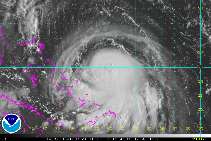
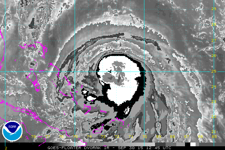
Convection still on the increase, outflow improving on the north side.
http://wwwghcc.msfc.nasa.gov/cgi-bin/get-goes?satellite=GOES-E%20CONUS&lat=25&lon=-73&info=vis&zoom=1&width=1000&height=800&quality=90&type=Animation&palette=ir1.pal&numframes=20&mapcolor=gray
http://wwwghcc.msfc.nasa.gov/cgi-bin/get-goes?satellite=GOES-E%20CONUS&lat=25&lon=-73&info=vis&zoom=1&width=1000&height=800&quality=90&type=Animation&palette=ir1.pal&numframes=20&mapcolor=gray
0 likes
M a r k
- - - - -
Join us in chat: Storm2K Chatroom Invite. Android and IOS apps also available.
The posts in this forum are NOT official forecasts and should not be used as such. Posts are NOT endorsed by any professional institution or STORM2K.org. For official information and forecasts, please refer to NHC and NWS products.
Who is online
Users browsing this forum: No registered users and 9 guests