Texas Fall-2015

U.S. & Caribbean Weather Discussions and Severe Weather Events

Moderator: S2k Moderators

Forum rules

The posts in this forum are NOT official forecast and should not be used as such. They are just the opinion of the poster and may or may not be backed by sound meteorological data. They are NOT endorsed by any professional institution or STORM2K.

Help Support Storm2K
Message
Author
User avatar
TheProfessor
Professional-Met
Professional-Met
Posts: 3506
Age: 28
Joined: Tue Dec 03, 2013 10:56 am
Location: Wichita, Kansas

#421 Postby TheProfessor » Thu Sep 24, 2015 3:04 pm

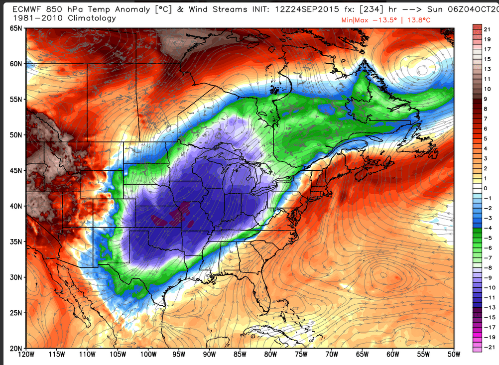
Brent wrote:Image


I like that map, maybe I can my first Freeze here if it verifies.
0 likes   
An alumnus of The Ohio State University.

Your local National Weather Service office is your best source for weather information.

User avatar
Tireman4
S2K Supporter
S2K Supporter
Posts: 5853
Age: 59
Joined: Fri Jun 30, 2006 1:08 pm
Location: Humble, Texas
Contact:

#422 Postby Tireman4 » Thu Sep 24, 2015 3:29 pm

Ok King Euro, do not forsake me....dang it...
0 likes   

User avatar
wxman57
Moderator-Pro Met
Moderator-Pro Met
Posts: 22978
Age: 67
Joined: Sat Jun 21, 2003 8:06 pm
Location: Houston, TX (southwest)

Re: Texas Fall-2015

#423 Postby wxman57 » Thu Sep 24, 2015 3:52 pm

I prefer the 12Z GFS - no cold fronts through Texas until beyond Oct. 10. ;-)

Interesting that the 12Z EC meteogram for DFW on WeatherBell has no cold front through day 10. Lows in the 70s and highs near 90 through 240hrs.
0 likes   

weatherdude1108
Category 5
Category 5
Posts: 4228
Joined: Tue Dec 13, 2011 1:04 pm
Location: Northwest Austin/Cedar Park, TX

Re: Texas Fall-2015

#424 Postby weatherdude1108 » Thu Sep 24, 2015 4:02 pm

Brent wrote:
weatherdude1108 wrote: :uarrow:
I'm liking that map! One more run,...one more run,...one more run... :cheesy:


I knew we weren't that lucky. :P

Image


UGH! Should have known. :roll:
0 likes   

Brent
S2K Supporter
S2K Supporter
Posts: 38089
Age: 36
Joined: Sun May 16, 2004 10:30 pm
Location: Tulsa Oklahoma
Contact:

Re: Texas Fall-2015

#425 Postby Brent » Thu Sep 24, 2015 4:18 pm

FWD:

LOOKING AHEAD...THE EXTENDED MODELS CONTINUE TO ADVERTISE SOME
RAIN CHANCES BY LATE NEXT WEEK WHEN AN UPPER TROUGH AND
ASSOCIATED COLD FRONT MOVE ACROSS THE CENTRAL AND SOUTHERN PLAINS.
0 likes   
#neversummer

User avatar
TeamPlayersBlue
Category 5
Category 5
Posts: 3445
Joined: Tue Feb 02, 2010 1:44 am
Location: Denver/Applewood, CO

#426 Postby TeamPlayersBlue » Thu Sep 24, 2015 4:58 pm

Loving the Euro! Its interesting, ive had my new weather station since mid- May and it give the solar radiation in watts/m^2. Curious to see the differences between hot summer sun reading and a mid winter sunny day reading. Yes im a dork.

Around June in the bright sun it would crack 1100 and now it is barely cracking 950. Pretty cool to see.
0 likes   
Personal Forecast Disclaimer:
The posts in this forum are NOT official forecast and should not be used as such. They are just the opinion of the poster and may or may not be backed by sound meteorological data. They are NOT endorsed by any professional institution or storm2k.org. For official information, please refer to the NHC and NWS products.

aggiecutter
Category 5
Category 5
Posts: 1753
Joined: Thu Oct 14, 2004 9:22 pm
Location: Texarkana

Re: Texas Fall-2015

#427 Postby aggiecutter » Thu Sep 24, 2015 5:13 pm

wxman57 wrote:I prefer the 12Z GFS - no cold fronts through Texas until beyond Oct. 10. ;-)

Interesting that the 12Z EC meteogram for DFW on WeatherBell has no cold front through day 10. Lows in the 70s and highs near 90 through 240hrs.


Image
0 likes   

Brent
S2K Supporter
S2K Supporter
Posts: 38089
Age: 36
Joined: Sun May 16, 2004 10:30 pm
Location: Tulsa Oklahoma
Contact:

Re: Texas Fall-2015

#428 Postby Brent » Thu Sep 24, 2015 6:37 pm

The 18z GFS doesn't look as drastic as the Euro... but it does drop temps back near average(low/mid 80s for most) starting next weekend, so there does seem to be some agreement in at least some kind of front. Unfortunately it is a dry front for most.

Coolest morning

Image
0 likes   
#neversummer

User avatar
Ntxw
Storm2k Moderator
Storm2k Moderator
Posts: 22785
Joined: Wed Oct 21, 2009 6:34 pm
Location: DFW, Texas

#429 Postby Ntxw » Thu Sep 24, 2015 7:08 pm

12z Euro Ensembles doesn't agree with the OP at 240 hours (10 days). Mostly holds ridging across the central and eastern conus. So why does the OP Euro show such a cold front? It has a big Aleutian low and a wavetrain. BS flag without ENS support :wink:. The ENS do show rising heights over Alaska and Canada but do keep the Aleutian ridging.
0 likes   
The above post and any post by Ntxw is NOT an official forecast and should not be used as such. It is just the opinion of the poster and may or may not be backed by sound meteorological data. It is NOT endorsed by any professional institution including Storm2k. For official information, please refer to NWS products.

  Help support Storm2K!
Help Support Storm2K

Brent
S2K Supporter
S2K Supporter
Posts: 38089
Age: 36
Joined: Sun May 16, 2004 10:30 pm
Location: Tulsa Oklahoma
Contact:

Re:

#430 Postby Brent » Thu Sep 24, 2015 7:21 pm

Ntxw wrote:12z Euro Ensembles doesn't agree with the OP at 240 hours (10 days). Mostly holds ridging across the central and eastern conus. So why does the OP Euro show such a cold front? It has a big Aleutian low and a wavetrain. BS flag without ENS support :wink:. The ENS do show rising heights over Alaska and Canada but do keep the Aleutian ridging.


GFS is zero rain for DFW after having over an inch at 6z...

Really hard for me to take anything seriously when nothing agrees.
0 likes   
#neversummer

User avatar
Ntxw
Storm2k Moderator
Storm2k Moderator
Posts: 22785
Joined: Wed Oct 21, 2009 6:34 pm
Location: DFW, Texas

Re: Re:

#431 Postby Ntxw » Thu Sep 24, 2015 7:55 pm

Brent wrote:GFS is zero rain for DFW after having over an inch at 6z...

Really hard for me to take anything seriously when nothing agrees.


The EPO refuses to go negative. A few days ago I responded to Tireman4 saying the models showing it could, but it's not as bullish now. The driver (El Nino) is eating away at the "blob" slowly.

Troughs in Alaska and NW Canada is not favorable for delivering cold fronts

Image
0 likes   
The above post and any post by Ntxw is NOT an official forecast and should not be used as such. It is just the opinion of the poster and may or may not be backed by sound meteorological data. It is NOT endorsed by any professional institution including Storm2k. For official information, please refer to NWS products.


  Help support Storm2K!

Help Support Storm2K


asd123
Category 1
Category 1
Posts: 265
Joined: Tue Sep 06, 2011 7:06 pm
Location: Orlando, Florida

Re:

#432 Postby asd123 » Thu Sep 24, 2015 8:53 pm

Ntxw wrote:12z Euro Ensembles doesn't agree with the OP at 240 hours (10 days). Mostly holds ridging across the central and eastern conus. So why does the OP Euro show such a cold front? It has a big Aleutian low and a wavetrain. BS flag without ENS support :wink:. The ENS do show rising heights over Alaska and Canada but do keep the Aleutian ridging.


I don't recall an operational model having ensemble support 9-10 days out. Consistency is the key. Once it gets to sooner than 7 days, then ensemble support can be seen. Now it's just model run consistency.

Interesting to see 00z ECMWF. 12z Euro run seems to have a significant southward movement component in cold air. Too bad ECMWF doesn't go beyond 10 days. Living in Orlando, FL I would be curious to see what form the cold air would make it.
0 likes   
This post is NOT AN OFFICIAL FORECAST and should not be used as such. It is just the opinion of the poster and may or may not be backed by sound meteorological data. It is NOT endorsed by any professional institution including storm2k.org. For Official Information please refer to the NHC and NWS products.

User avatar
Texas Snowman
Storm2k Moderator
Storm2k Moderator
Posts: 6179
Joined: Fri Jan 25, 2008 11:29 am
Location: Denison, Texas

Re: Re:

#433 Postby Texas Snowman » Fri Sep 25, 2015 12:22 am

Ntxw wrote:The EPO refuses to go negative. A few days ago I responded to Tireman4 saying the models showing it could, but it's not as bullish now. The driver (El Nino) is eating away at the "blob" slowly.

Troughs in Alaska and NW Canada is not favorable for delivering cold fronts


Ntxw, last year it was Portastorm getting trapped over on the dark side. Now don't you go and get sucked in by the Heat Miser and pull a "Fall and Winter Cancel" on us, especially before it even really begins!

Remember, resistance is NOT futile! :)
0 likes   
The above post and any post by Texas Snowman is NOT an official forecast and should not be used as such. It is just the opinion of the poster and may or may not be backed by sound meteorological data. It is NOT endorsed by any professional institution including storm2k.org. For official information, please refer to NWS products.

Brent
S2K Supporter
S2K Supporter
Posts: 38089
Age: 36
Joined: Sun May 16, 2004 10:30 pm
Location: Tulsa Oklahoma
Contact:

Re: Texas Fall-2015

#434 Postby Brent » Fri Sep 25, 2015 1:17 am

GFS has all the good stuff at 300+ hours at 0z. :roll: On the bright side... it does have significant rain for DFW within 384 hours. :P

Weatherbug still has temps closer to average after Tuesday next week... (mid 80s/mid 60s) and has introduced rain chances in the Fri/Sat timeframe...
0 likes   
#neversummer

User avatar
Ntxw
Storm2k Moderator
Storm2k Moderator
Posts: 22785
Joined: Wed Oct 21, 2009 6:34 pm
Location: DFW, Texas

Re: Re:

#435 Postby Ntxw » Fri Sep 25, 2015 8:04 am

Texas Snowman wrote:Ntxw, last year it was Portastorm getting trapped over on the dark side. Now don't you go and get sucked in by the Heat Miser and pull a "Fall and Winter Cancel" on us, especially before it even really begins!

Remember, resistance is NOT futile! :)


No sir none of that! I hate summer and I'm sick of it already :lol:

I was just trying to point out the signal at this time hasn't been favorable. When it flips you know I'll be the first to point it out!
0 likes   
The above post and any post by Ntxw is NOT an official forecast and should not be used as such. It is just the opinion of the poster and may or may not be backed by sound meteorological data. It is NOT endorsed by any professional institution including Storm2k. For official information, please refer to NWS products.


  Help support Storm2K!

Help Support Storm2K


User avatar
dhweather
S2K Supporter
S2K Supporter
Posts: 6199
Joined: Sat Aug 14, 2004 9:29 pm
Location: Heath, TX
Contact:

Re:

#436 Postby dhweather » Fri Sep 25, 2015 11:11 am

Ntxw wrote:This September is going to end up one of the warmest (top 10) for DFW. I don't know the records for IAH and Austin but I think it's up there too. The nearest warm September year similar is 2013 and the warmest is 2005.

Average for September is 78F. We haven't had a cooler Sept than average since 2009.


It hasn't been 2011 hot July-September, but this ridge has been similarly brutal. Less rain in 2015.

August 25th to September 25th 2011 - Heath, TX

Image

August 25th to September 25th 2015 - Heath, TX

Image
0 likes   
The above post and any post by dhweather is NOT an official forecast and should not be used as such. It is just the opinion of the poster and may or may not be backed by sound meteorological data. It is NOT endorsed by any professional institution including storm2k.org. For official information, please refer to NWS products.

User avatar
Ntxw
Storm2k Moderator
Storm2k Moderator
Posts: 22785
Joined: Wed Oct 21, 2009 6:34 pm
Location: DFW, Texas

Re: Texas Fall-2015

#437 Postby Ntxw » Fri Sep 25, 2015 11:27 am

July-Sept of 2011 DFW recorded 1.71 inches of rain. And that was one of the wetter locations that summer around north Texas. July-Sept 2015 DFW has recorded 3.52 inches or almost double. May be one of the wetter spots, most areas have seen around 2-2.5 inches.

If you wanted to count NOAA's classification of summer (June-July-August) June of this year alone had more rain than all three months of meteorological summer 2011 combined.

The last 3 months has been warm, and dry. But I still stand by the fact it is not in conversation with 2011.
0 likes   
The above post and any post by Ntxw is NOT an official forecast and should not be used as such. It is just the opinion of the poster and may or may not be backed by sound meteorological data. It is NOT endorsed by any professional institution including Storm2k. For official information, please refer to NWS products.


  Help support Storm2K!

Help Support Storm2K


User avatar
dhweather
S2K Supporter
S2K Supporter
Posts: 6199
Joined: Sat Aug 14, 2004 9:29 pm
Location: Heath, TX
Contact:

#438 Postby dhweather » Fri Sep 25, 2015 11:35 am

Digging through my weather station data from 2011 for Heath, our first high temperature below 70 was October 18th. First low below 50 was October 20th. On the bright side, we did get 4.14" of rain in October 2011

October rains:

October 2010 0.98"
October 2011 4.14"
October 2012 1.70"
October 2013 1.17"
October 2014 3.95"
October 2015 ?????
0 likes   
The above post and any post by dhweather is NOT an official forecast and should not be used as such. It is just the opinion of the poster and may or may not be backed by sound meteorological data. It is NOT endorsed by any professional institution including storm2k.org. For official information, please refer to NWS products.

User avatar
dhweather
S2K Supporter
S2K Supporter
Posts: 6199
Joined: Sat Aug 14, 2004 9:29 pm
Location: Heath, TX
Contact:

Re: Texas Fall-2015

#439 Postby dhweather » Fri Sep 25, 2015 11:42 am

Ntxw wrote:July-Sept of 2011 DFW recorded 1.71 inches of rain. And that was one of the wetter locations that summer around north Texas. July-Sept 2015 DFW has recorded 3.52 inches or almost double. May be one of the wetter spots, most areas have seen around 2-2.5 inches.

If you wanted to count NOAA's classification of summer (June-July-August) June of this year alone had more rain than all three months of meteorological summer 2011 combined.

The last 3 months has been warm, and dry. But I still stand by the fact it is not in conversation with 2011.


Actual temperatures, no its not.

Add in heat index, 2015 has been hot and sticky. Precipitation wise, 0.15" separate the two in Heath.

2011 July-August-September rainfall 1.44"

2015 July-August-September rainfall 1.59" *assuming no rain 25th-30th

Both years murdered my yard, killed some shrubs and trees, and have cracks in the soil you can literally hurt yourself on.
0 likes   
The above post and any post by dhweather is NOT an official forecast and should not be used as such. It is just the opinion of the poster and may or may not be backed by sound meteorological data. It is NOT endorsed by any professional institution including storm2k.org. For official information, please refer to NWS products.

User avatar
Ntxw
Storm2k Moderator
Storm2k Moderator
Posts: 22785
Joined: Wed Oct 21, 2009 6:34 pm
Location: DFW, Texas

Re:

#440 Postby Ntxw » Fri Sep 25, 2015 11:45 am

dhweather wrote:Digging through my weather station data from 2011 for Heath, our first high temperature below 70 was October 18th. First low below 50 was October 20th. On the bright side, we did get 4.14" of rain in October 2011


That period then began what was to be the 6th wettest (consequently a very warm one) winter
0 likes   
The above post and any post by Ntxw is NOT an official forecast and should not be used as such. It is just the opinion of the poster and may or may not be backed by sound meteorological data. It is NOT endorsed by any professional institution including Storm2k. For official information, please refer to NWS products.


  Help support Storm2K!

Help Support Storm2K


Return to “USA & Caribbean Weather”

Who is online

Users browsing this forum: No registered users and 18 guests