Most interesting tropical cyclones?

This is the general tropical discussion area. Anyone can take their shot at predicting a storms path.

Moderator: S2k Moderators

Forum rules

The posts in this forum are NOT official forecasts and should not be used as such. They are just the opinion of the poster and may or may not be backed by sound meteorological data. They are NOT endorsed by any professional institution or STORM2K. For official information, please refer to products from the National Hurricane Center and National Weather Service.

Help Support Storm2K
Message
Author
User avatar
Jam151
Category 1
Category 1
Posts: 276
Joined: Fri Aug 26, 2005 12:09 pm

Most interesting tropical cyclones?

#1 Postby Jam151 » Tue Sep 01, 2015 5:41 pm

Figure this might be a cool thing to discuss: Which tropical cyclones do you consider to be the most interesting?

Here is my list, in chronological order. I'm only including storms that I've tracked (1998-present). This list has more storms from the Atlantic than from other basins, since I watch the Atlantic more closely. Feel free to do your list however you wish!

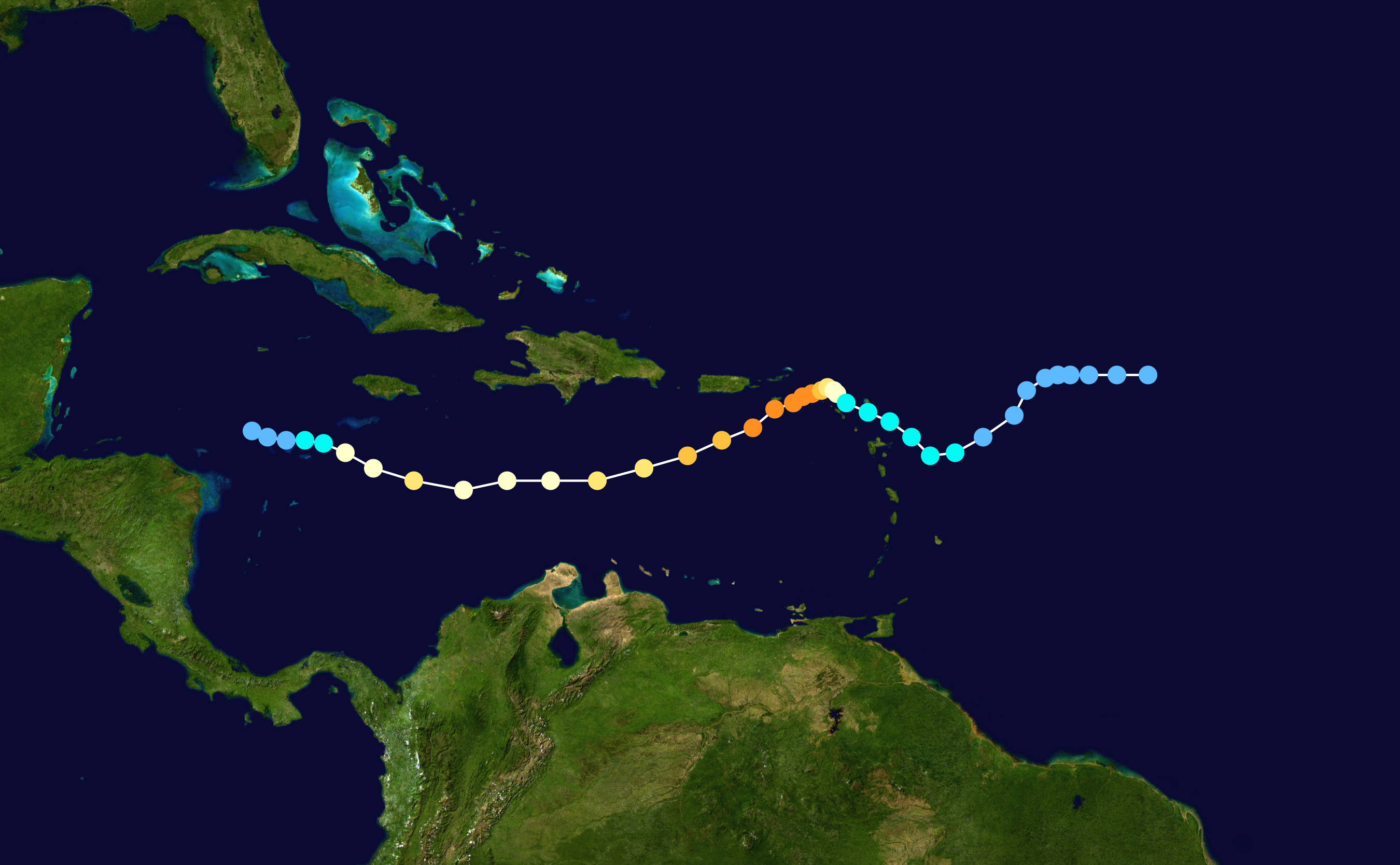
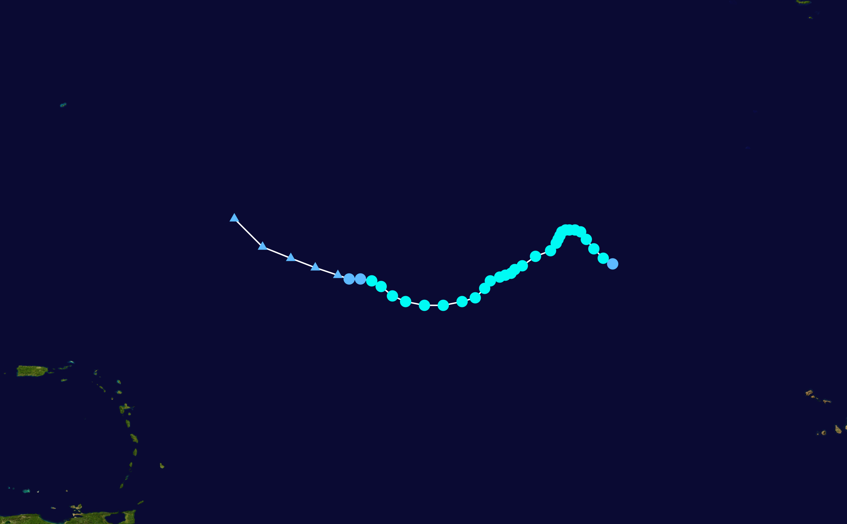
Hurricane Lenny (1999) - eastward track across the Caribbean Sea, peak of 155mph in the second half of November
Image

Cyclone Leon-Eline (2000) - long track from south of Indonesia to well inland Africa, remnant circulation traced all the way to Namibia
Image

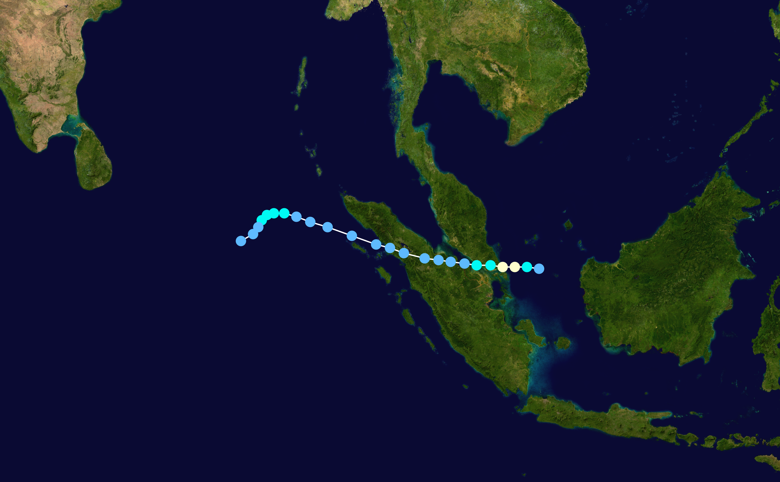
Typhoon Vamei (2001) - formation within 1.5 degrees of the equator, hit just north of Singapore
Image

Tropical Storm Ana (2003) - Atlantic formation in April, lasted 3 days as a tropical storm
Image

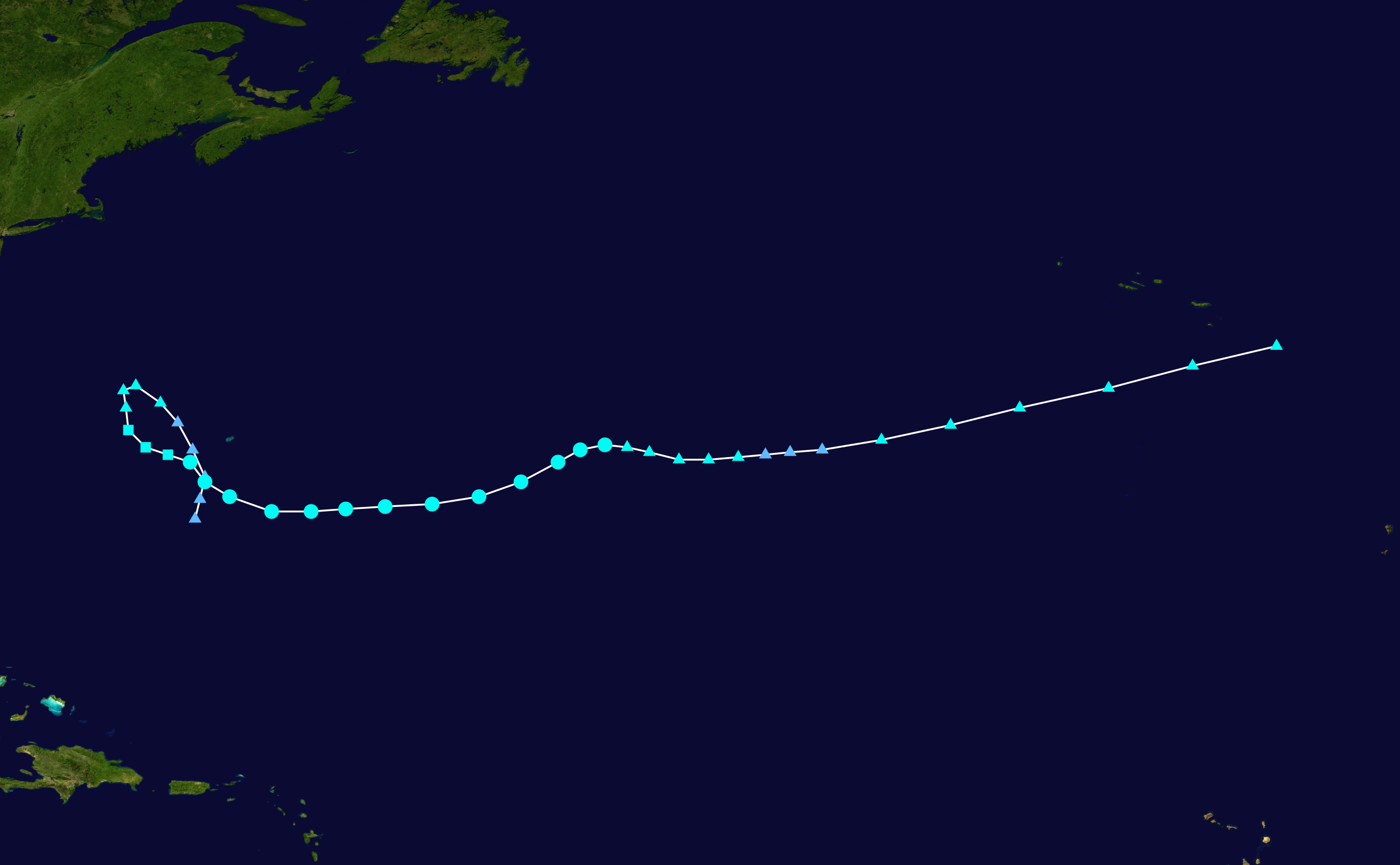
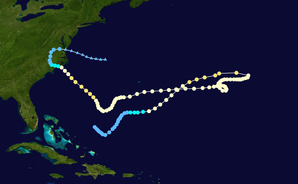
Hurricane Juan (2003) - slammed into Nova Scotia as a well-defined category 2 hurricane
Image

Cyclone Catarina (2004) - category 2 cyclone formation in the South Atlantic, hit Brazil at peak intensity
Image

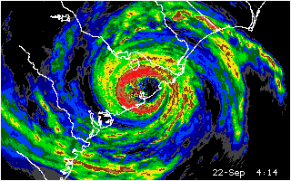
Hurricane Charley (2004) - rapid intensification from a category 2 to 150mph in the 7 hours preceding landfall in western Florida
Image

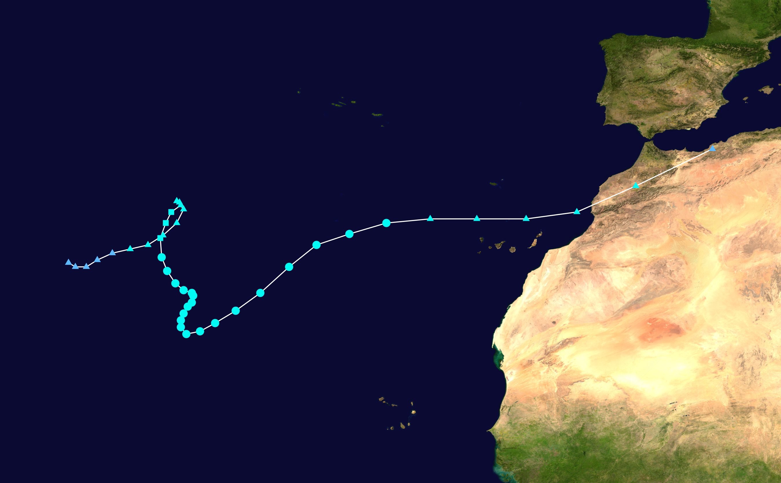
Hurricane Vince (2005) - hurricane formation in far northeast Atlantic near Madeira, hit Spain as a tropical depression
Image

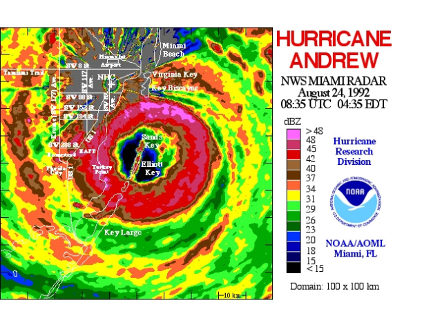
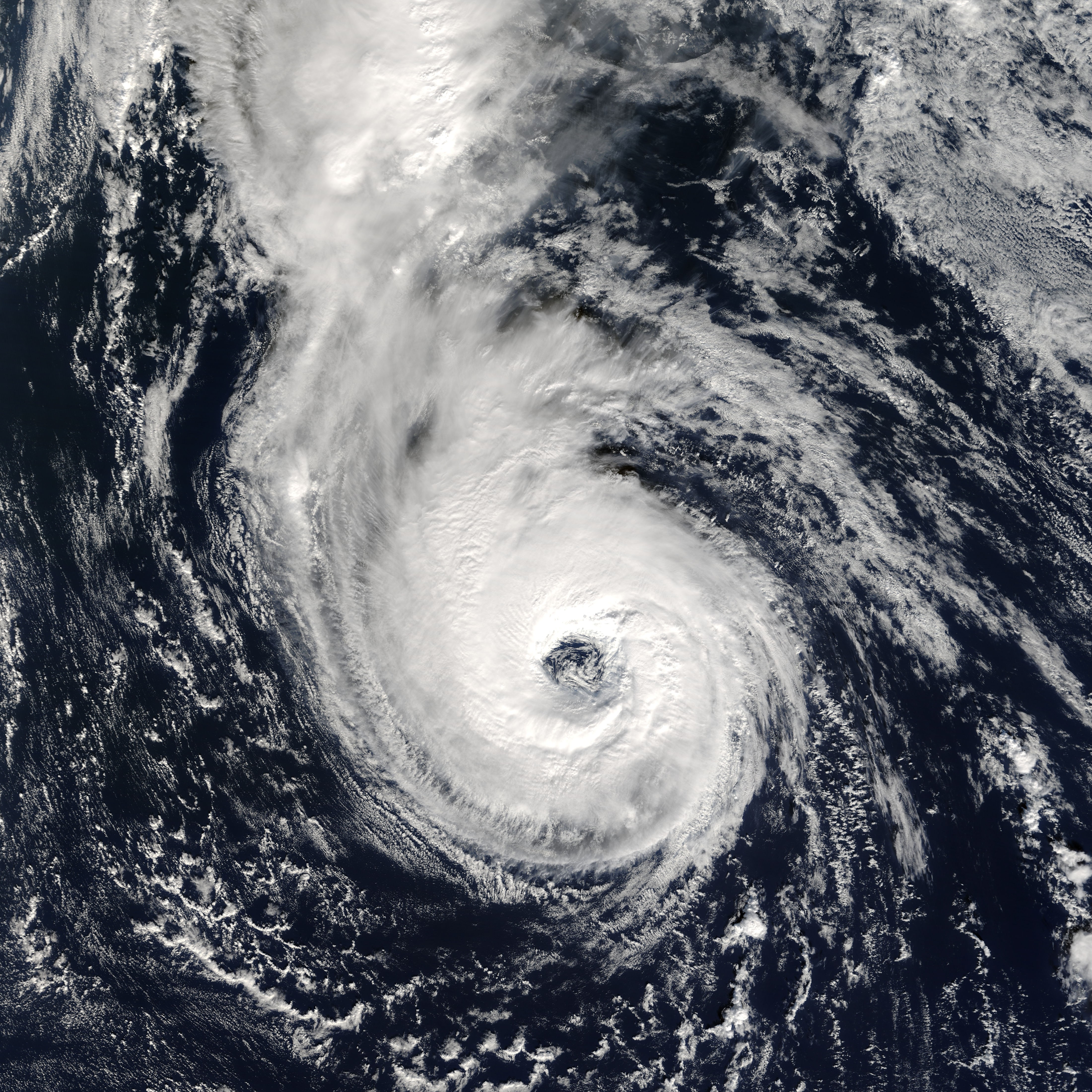
Hurricane Wilma (2005) - explosive intensification from category 1 to 882mb in 18 hours, tiny pinhole eye
Image

Tropical Storm Delta (2005) - impacted the Canary Islands and Morocco shortly after becoming a strong extratropical storm
Image

Hurricane Epsilon (2005) - lasted more than 4 days as a well-defined hurricane over waters around 72 degrees F in December
Image

Tropical Storm Zeta (2005) - existed as a fairly organized Atlantic tropical storm for several days in January
Image

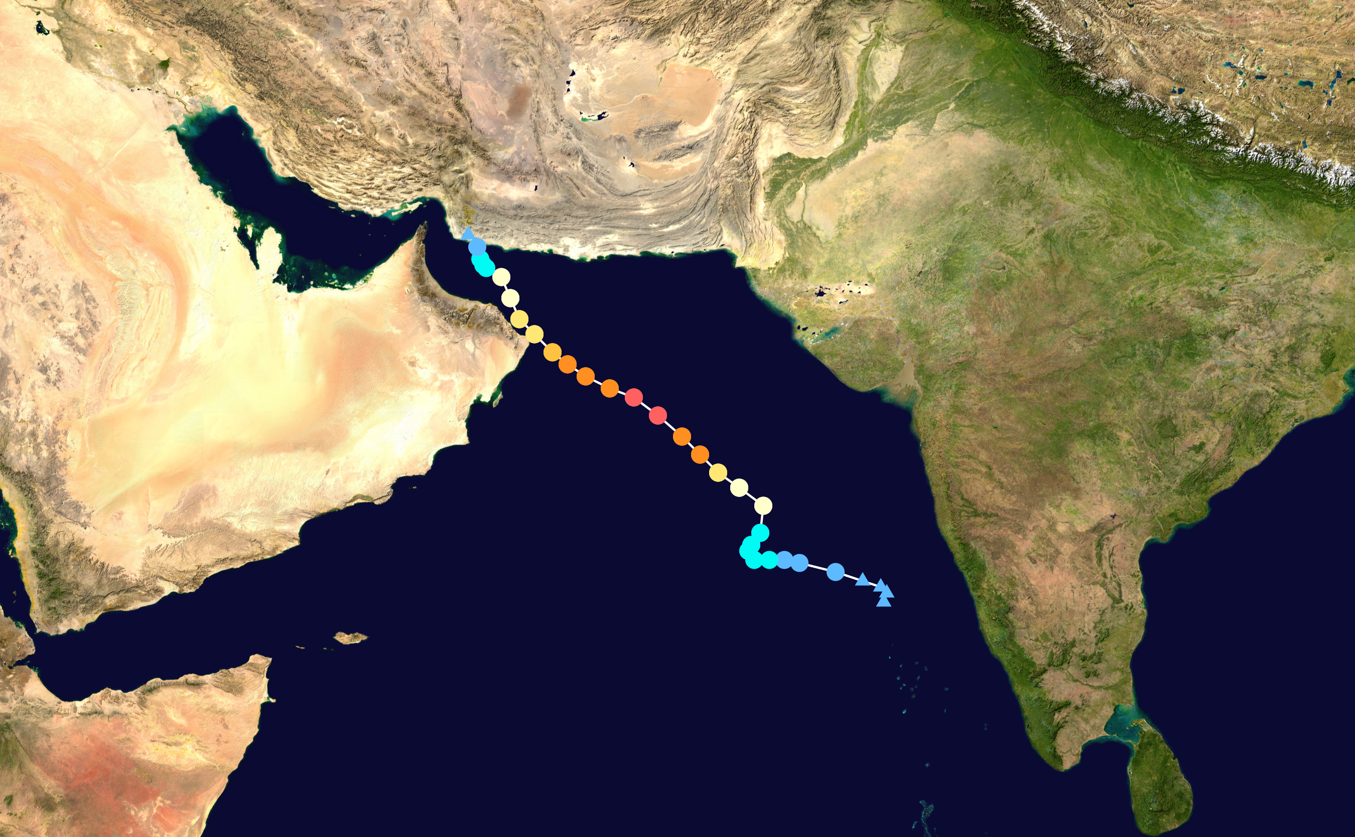
Cyclone Gonu (2007) - tracked into the Gulf of Oman as a cyclone, hit Iran as a tropical depression
Image

Hurricane Humberto (2007) - rapid intensification from showers to a 90mph hurricane in just 18 hours preceding landfall in Texas
Image

Tropical Storm Alma (2008) - Pacific formation very far east, hit west coast of Nicaragua as a strong tropical storm
Image

Hurricane Sandy (2012) - very large and deep hurricane that phased, swung west into New Jersey as a 943mb extratropical cyclone
Image

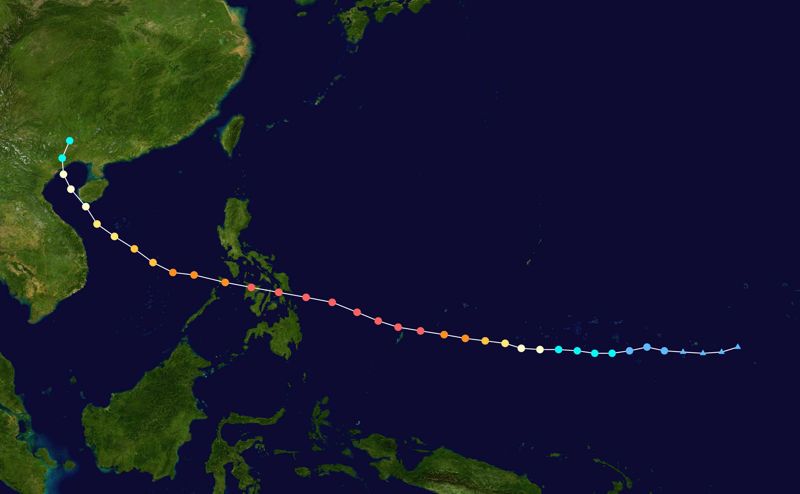
Typhoon Haiyan (2013) - very powerful 195mph tropical cyclone, slammed into the Philippines near peak intensity
Image

Hurricane Fred (2015) - became a hurricane east of Cape Verde, passed through the islands as a hurricane
Image
0 likes   

User avatar
Hammy
Category 5
Category 5
Posts: 5849
Age: 41
Joined: Fri May 25, 2012 5:25 pm
Contact:

Re: Most interesting tropical cyclones?

#2 Postby Hammy » Tue Sep 01, 2015 6:19 pm

Image
John 1994

https://upload.wikimedia.org/wikipedia/commons/a/aa/Ginger_1971_track.png
Ginger 1971

Image
Ginny 1963

A few of the longer ones that came to mind.
0 likes   
The above post is not official and should not be used as such. It is the opinion of the poster and may or may not be backed by sound meteorological data. It is not endorsed by any professional institution or storm2k.org. For official information, please refer to the NHC and NWS products.

User avatar
galaxy401
Category 5
Category 5
Posts: 2419
Age: 30
Joined: Sat Aug 25, 2012 9:04 pm
Location: Casa Grande, Arizona

Re: Most interesting tropical cyclones?

#3 Postby galaxy401 » Tue Sep 01, 2015 6:57 pm

Image

Grace 2009. Formed farther north than Vince.

Image

Nadine 2012. Didn't know where it wanted to go.
0 likes   
Got my eyes on moving right into Hurricane Alley: Florida.

tatertawt24
Category 1
Category 1
Posts: 309
Joined: Wed Oct 24, 2012 12:57 pm

Re: Most interesting tropical cyclones?

#4 Postby tatertawt24 » Mon Sep 07, 2015 4:57 pm

Image

1938 Long Island Express Hurricane: Will always be one of the most interesting storms of all time, because as with any storm from that long ago, we'll never know for sure exactly what happened. The popular theory is that 1938 was a very rare warm-seclusion extratropical cyclone, which is similar to a subtropical storm but on a much, much more mature level. It's basically a strong extratropical storm with a warm core tropical-like cyclone embedded in the center. They often have eyes, eyewalls, and pretty impressive convection -- especially for a storm going extratrop. transition. This would explain the unusual strength that far north, and would also explain the accounts of what sounds like a pretty classic eye passing. Something else interesting is the speed that it was going at, which of course greatly enhanced the winds at landfall, but also seems possibly characteristic of warm-seclusion storms. Hazel occurred around the same time of year (between September 21st and October 21st), also moved at extremely fast speeds, had a calm eye at landfall, and had devastating winds unusually far north.

Image

Hurricane Janet: I wouldn't be surprised if this was the second-strongest hurricane to make landfall in the Atlantic in the 20th century, in terms of wind speeds. The airport in Chetumal reported a gust of 175 mph before it failed. Also responsible for (so far) the only direct Hurricane Hunter fatalities during recon on the night of the 26th. I'm thinking it pulled a Hugo and intensified much more severely and rapidly than they expected, and got caught in the updrafts and downdrafts. On the night before, recon did report lightning.

Image

Hurricane Celia: The first thing that came to mind for me. Explosively intensified just before landfall (Texas's Charley) and caused some of the most intense wind-related damage ever -- not to mention it was square in Corpus Christi. The Corpus Christi Airport reading before failure is the most impressive I can think of off the top of my head -- actually recorded sustained upper-end cat 3 winds, which is pretty rare. Also a 161 mph gust! The most devastating winds had a strange explosive quality to them, happening within a very short time in a sequence of even shorter bursts, described as being like rocket shells. Most interesting is the fact that the strongest winds occurred in the left eyewall as opposed to the right.

Image

Hurricane Hugo: Slowly intensified and then remained steady on its trek towards South Carolina. Large, well defined eye at landfall and decent eyewall on radar. Not to mention the fact that it was large, which makes the cat 4 intensity even more impressive. This seems reasonable based on damage in the Eastern eyewall -- the Francis Marion National Forest was just about decimated (I believe I remember reading somewhere that some of the trees were actually GONE instead of just snapped). By far one of the strongest "Complete package" hurricanes (both wind and water power) in the 20th century -- along with Carla.

Image

Hurricane Andrew: I would pay so much money to see a video of one of the mini-swirls in Naranja Lakes. I can't imagine what one of those things would look like. Hard to imagine winds in a hurricane being so strong that cars were lifted and flipped the way they were. imo it still has the best eyewall ever recorded on radar thus far. The storm just has this creepy vibe surrounding it. There are so many home videos during it, yet I know of no footage taken in the eyewall. It's one of those things where we'll never really know what happened or just how bad it was, because the time between around 4-6 am in the Homestead area was just a huge blur. The roar of the wind was so loud you could barely hear someone screaming beside you. It must have been very disorienting and hell-ish. I read an article awhile ago about PTSD sufferers from Andrew. There were similar traumatic experiences in Hugo, Janet, (one of the Swan Island victims said he still woke up with nightmares) and, I'm sure for anyone that actually survived it, 1935. There's a legend from the 1935 storm of a guy that got knocked out by flying debris, and woke up seeing sparks in the air from frictioned sand, leading him to think he was in hell. I take any of these rumors with a grain of salt though, after the Richeliu Manor legend after Camille.

Image

Hurricane Alex (2004): Its strength so far north gives hope to any New Englander who wants to see a truly tropical major hurricane in their vicinity. :lol:

Image

Hurricane Charley: Of course. :D The exemplar for explosive intensification at the worst possible time. By far the worst (and still the worst) wind damage observed in the US since Andrew.

Image

Hurricane Epsilon: I'm using this to pretty much exemplify the 2005 season. It's like the storms in 2005 had something against meteorologists and just did whatever they could to troll them and prove them wrong. Weirdest storm ever, definitely.
0 likes   
Personal Forecast Disclaimer:
The posts in this forum are NOT official forecast and should not be used as such. They are just the opinion of the poster and may or may not be backed by sound meteorological data. They are NOT endorsed by any professional institution or storm2k.org. For official information, please refer to the NHC and NWS products.

CrazyC83
Professional-Met
Professional-Met
Posts: 34002
Joined: Tue Mar 07, 2006 11:57 pm
Location: Deep South, for the first time!

#5 Postby CrazyC83 » Mon Sep 07, 2015 9:48 pm

Awaiting reanalysis, but a hurricane off the NC coast looping just offshore the week after Thanksgiving in 1962 sure is interesting...
0 likes   


Return to “Talkin' Tropics”

Who is online

Users browsing this forum: MarioProtVI, SconnieCane, StormWeather, Ulf and 53 guests