ATL: ERIKA - Remnants - Discussion
Moderator: S2k Moderators
-
northjaxpro

- S2K Supporter

- Posts: 8900
- Joined: Mon Sep 27, 2010 11:21 am
- Location: Jacksonville, FL
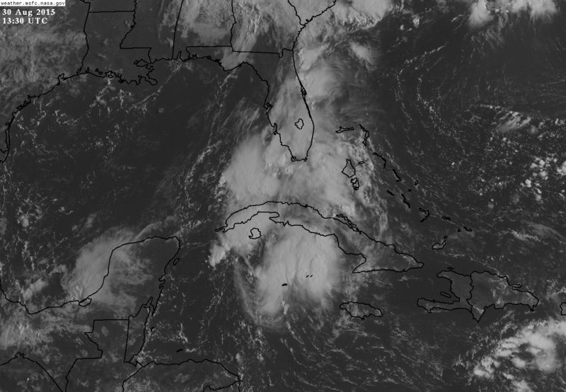
The ULL has drifted east/northeast the past 12-24 hours, with the ULL now over Southern AL/FL Panhandle region. Yesterday, it was over New Orleans/Mississippi coast region. The ULL has now bought in some drier air from the west, as sern on WV imagery, which has worked in across.the Florida Panhandle and now into portions of North Florida this morning. Looks as for right now the rains will stay confined across the Central and South Florida. The rain will come back big time across North Florida on Monday when thr trough axis lifts back to the north, combined with Erika's remnants. Wet times ahead this week.
Last edited by northjaxpro on Sun Aug 30, 2015 9:01 am, edited 1 time in total.
0 likes
NEVER, EVER SAY NEVER in the tropics and weather in general, and most importantly, with life itself!!
________________________________________________________________________________________
Fay 2008 Beryl 2012 Debby 2012 Colin 2016 Hermine 2016 Julia 2016 Matthew 2016 Irma 2017 Dorian 2019
________________________________________________________________________________________
Fay 2008 Beryl 2012 Debby 2012 Colin 2016 Hermine 2016 Julia 2016 Matthew 2016 Irma 2017 Dorian 2019


The sunrise in Miami today was so creepy, a bright red sky... looked apocalyptic. We should be getting some more rain later, but I think the worst has passed for us overnight. What a night!
0 likes
I have no clue what I'm talking about, this is a FORUM not a weather station, please don't listen to me and base your actions on what the NHC says.

Lots of tropical moisture around 90L this morning, the NHC fixed the remnant vorticity of Erika at 24.7N & 82.4W, just W of Key West, at 12z. The ULL over the north central gulf coast is forecasted to move northward today so UL conditions are forecasted to improve a little starting this afternoon through Tuesday over the eastern GOM, if the vorticity stays offshore through Tuesday it may have chance to redevelop before moving inland over the big bend area of the FL Panhandle by then. Big rains for FL is a sure bet whether it redevelops or not.
Personal Forecast Disclaimer:
The posts in this forum are NOT official forecast and should not be used as such. They are just the opinion of the poster and may or may not be backed by sound meteorological data. They are NOT endorsed by any professional institution or storm2k.org. For official information, please refer to the NHC and NWS products.
0 likes
-
northjaxpro
- S2K Supporter
- Posts: 8900
- Joined: Mon Sep 27, 2010 11:21 am
- Location: Jacksonville, FL
Yes NDG there will be an impressive moisture surge. The next 48-72 hours across the peninsula. I am very curious about that deep moisture down south of Cuba.
0 likes
NEVER, EVER SAY NEVER in the tropics and weather in general, and most importantly, with life itself!!
________________________________________________________________________________________
Fay 2008 Beryl 2012 Debby 2012 Colin 2016 Hermine 2016 Julia 2016 Matthew 2016 Irma 2017 Dorian 2019
________________________________________________________________________________________
Fay 2008 Beryl 2012 Debby 2012 Colin 2016 Hermine 2016 Julia 2016 Matthew 2016 Irma 2017 Dorian 2019
-
Weatherlover12
- Tropical Depression

- Posts: 68
- Joined: Wed Aug 19, 2015 11:41 am
Re: ATL: INVEST 90L - ERIKA Remnants - Discussion
We are getting a lot of much needed rain down in central FLm
But I'm wondering about the blob south of Cuba? It's curious and is that separate from Erika?
But I'm wondering about the blob south of Cuba? It's curious and is that separate from Erika?
0 likes
Re: ATL: INVEST 90L - ERIKA Remnants - Discussion
Weatherlover12 wrote:We are getting a lot of much needed rain down in central FLm
But I'm wondering about the blob south of Cuba? It's curious and is that separate from Erika?
That's all Erika's remnants, some mid level energy lagging behind her LL vorticity.
0 likes
-
SouthFloridawx

- S2K Supporter
- Posts: 8346
- Age: 47
- Joined: Tue Jul 26, 2005 1:16 am
- Location: Sarasota, FL
- Contact:
ATL: INVEST 90L - ERIKA Remnants - Discussion
NDG wrote:Discussion from Melbourne NWS made me laugh this morning while having my coffee.MON-TUE...WET PATTERN LIKELY TO CONTINUE FOR MON AS REMNANT LOW
PRESSURE TROUGH FROM WHAT WAS ERIKA TRANSITIONS TO THE E GULF OF
MEXICO WHILE SEARCHING FOR DIRECTION AND PURPOSE. THERE DOES REMAIN
SOME VERY MODEST OPPORTUNITY FOR REGENERATION...BUT MUCH WOULD
DEPEND UPON THE UPPER WINDS AND FORTUNE. EVEN SO...ANOMALOUSLY
HIGH PWATS (EVEN FOR AUG/SEP) ARE THE LOCAL CONCERN AS THE
POTENTIAL FOR FLOODING RAIN CONTINUES WITH THE TROPICAL MOISTURE
PLUME PULLED N. CHANCE FOR HIGHER TOTALS SKEWED TOWARD THE W
PENINSULA CLOSER TO FEATURE...BUT SIMPLY CANNOT DOWNPLAY THREAT IN
THE PRESENCE OF 2.3 INCHES OF PWAT.
http://forecast.weather.gov/product.php ... glossary=0
Haha
0 likes

Re: ATL: INVEST 90L - ERIKA Remnants - Discussion
CourierPR wrote:donjon wrote:Lowest pressure at 7 am was Key West Int at 29.87 in with SE winds at 20 mph.
What are we witnessing in that ball of convection south of Cuba?
I mentioned that earlier this morning, the system was split by the mountains and there is an area of shallow surface pressure south of Cuba pumping convection.
Looking at the visible pics this morning there does appear to be some lower level cloud movement below the mid level circulation remnants.
Generally a broad surface low doesn't have the pressure gradient to regenerate rapidly.
NHC did say shear would be lessening in a few days.
Would south of Cuba be 91L?
0 likes
-
northjaxpro
- S2K Supporter
- Posts: 8900
- Joined: Mon Sep 27, 2010 11:21 am
- Location: Jacksonville, FL
0 likes
NEVER, EVER SAY NEVER in the tropics and weather in general, and most importantly, with life itself!!
________________________________________________________________________________________
Fay 2008 Beryl 2012 Debby 2012 Colin 2016 Hermine 2016 Julia 2016 Matthew 2016 Irma 2017 Dorian 2019
________________________________________________________________________________________
Fay 2008 Beryl 2012 Debby 2012 Colin 2016 Hermine 2016 Julia 2016 Matthew 2016 Irma 2017 Dorian 2019
-
OuterBanker
- S2K Supporter
- Posts: 1761
- Joined: Wed Feb 26, 2003 10:53 am
- Location: Nags Head, NC
- Contact:
Re: ATL: INVEST 90L - ERIKA Remnants - Discussion
I know that Fla is getting flooding rains, but the ULL save you from a tropical system. It really prevented any tropical development. BTW, what's that around 35 n 70 w.
0 likes
Re: ATL: INVEST 90L - ERIKA Remnants - Discussion
OuterBanker wrote:I know that Fla is getting flooding rains, but the ULL save you from a tropical system. It really prevented any tropical development. BTW, what's that around 35 n 70 w.
That's just a weak area of low pressure, lots of westerly shear over it, no development expected.
0 likes
-
daylynsmom

- S2K Supporter
- Posts: 13
- Age: 55
- Joined: Fri May 01, 2015 2:07 pm
- Location: Lake Buena Vista, FL
Re: ATL: INVEST 90L - ERIKA Remnants - Discussion
OuterBanker wrote:I know that Fla is getting flooding rains, but the ULL save you from a tropical system. It really prevented any tropical development. BTW, what's that around 35 n 70 w.
Waiting on those flooding rains. Nothing since 5am. Overnight there were some pretty impressive Tstorms but it has been sunny & overcast the past couple hours.
0 likes
~Deedles
This post is NOT AN OFFICIAL FORECAST and should not be used as such. It is just the opinion of the poster and may or may not be backed by sound meteorological data. It is NOT endorsed by any professional institution including storm2k.org. For Official Information please refer to the NHC and NWS products.
This post is NOT AN OFFICIAL FORECAST and should not be used as such. It is just the opinion of the poster and may or may not be backed by sound meteorological data. It is NOT endorsed by any professional institution including storm2k.org. For Official Information please refer to the NHC and NWS products.
Re: ATL: INVEST 90L - ERIKA Remnants - Discussion
Just weak remnants flared by shear. No wind here.
0 likes
-
northjaxpro
- S2K Supporter
- Posts: 8900
- Joined: Mon Sep 27, 2010 11:21 am
- Location: Jacksonville, FL
Observing Key West radar the LLC/vort about 60-70 miles west/southwest of Key West is becoming a bit more defined in its presentation imo.
0 likes
NEVER, EVER SAY NEVER in the tropics and weather in general, and most importantly, with life itself!!
________________________________________________________________________________________
Fay 2008 Beryl 2012 Debby 2012 Colin 2016 Hermine 2016 Julia 2016 Matthew 2016 Irma 2017 Dorian 2019
________________________________________________________________________________________
Fay 2008 Beryl 2012 Debby 2012 Colin 2016 Hermine 2016 Julia 2016 Matthew 2016 Irma 2017 Dorian 2019
-
tropicwatch

- Category 5

- Posts: 3426
- Age: 62
- Joined: Sat Jun 02, 2007 10:01 am
- Location: Panama City Florida
- Contact:
Decent vorticity in the Florida straits.

Last edited by tolakram on Sun Aug 30, 2015 7:14 pm, edited 1 time in total.
Reason: fixed image
Reason: fixed image
0 likes
Tropicwatch
Agnes 72', Eloise 75, Elena 85', Kate 85', Charley 86', Florence 88', Beryl 94', Dean 95', Erin 95', Opal 95', Earl 98', Georges 98', Ivan 2004', Arlene 2005', Dennis 2005', Ida 2009' Debby 2012' Irma 2017' Michael 2018'
Agnes 72', Eloise 75, Elena 85', Kate 85', Charley 86', Florence 88', Beryl 94', Dean 95', Erin 95', Opal 95', Earl 98', Georges 98', Ivan 2004', Arlene 2005', Dennis 2005', Ida 2009' Debby 2012' Irma 2017' Michael 2018'
Re: ATL: INVEST 90L - ERIKA Remnants - Discussion
Yeah, it's a real mistake to write any established vortex off before it crosses the Gulf Stream, even in hostile shear.
Do you think that's the center?
Do you think that's the center?
0 likes
Re: ATL: INVEST 90L - ERIKA Remnants - Discussion
You can see the old mid level vort from Pico San Juan, it would be funny if they both managed to get going, now they are so far apart.

0 likes
Re: ATL: INVEST 90L - ERIKA Remnants - Discussion
boca wrote:Here in East Boca we are just out of the conveyor belt of rain unless the rain band shifts east we aren't going to get much up here today
Actually, here in East Boca at 12:30 pm the sun is shining! Windy and sunny...neighbors standing around and talking about it in disbelief. A few kids are flying kites. We did have storms last night...maybe more will come through later.
So much for Erika.
BocaGirl
Barbara
0 likes
Re:
northjaxpro wrote:Observing Key West radar the LLC/vort about 60-70 miles west/southwest of Key West is becoming a bit more defined in its presentation imo.
Yes, the rotation motion is stronger compared to some hours ago.
0 likes
Personal Forecast Disclaimer:
The posts in this forum are NOT official forecast and should not be used as such. They are just the opinion of the poster and may or may not be backed by sound meteorological data. They are NOT endorsed by any professional institution or storm2k.org. For official information, please refer to the NHC and NWS products.
The posts in this forum are NOT official forecast and should not be used as such. They are just the opinion of the poster and may or may not be backed by sound meteorological data. They are NOT endorsed by any professional institution or storm2k.org. For official information, please refer to the NHC and NWS products.
-
ObsessedMiami

- Category 1

- Posts: 432
- Joined: Tue Aug 31, 2004 8:08 pm
- Location: West Kendall, Fl
Re: ATL: INVEST 90L - ERIKA Remnants - Discussion
Based on my superficial observation, most of this moisture is south of the straits and the system is moving north, so most of the rainfall would track north and occur this afternoon through tomorrow morning in SFL. Kind of silly to see people saying Erika wasn't anything.
0 likes
Who is online
Users browsing this forum: No registered users and 9 guests