ATL: ERIKA - Remnants - Discussion
Moderator: S2k Moderators
-
ozonepete
- Professional-Met

- Posts: 4743
- Joined: Mon Sep 07, 2009 3:23 pm
- Location: From Ozone Park, NYC / Now in Brooklyn, NY
Re: Re:
drewschmaltz wrote:bamajammer4eva wrote:I would think that hole in the middle is nothing but a mountain peak and the convection is all being forced around it rather than being a sign of organization. Kind of like if you have a pile of dirt in the middle of a plate and pour water in the plate water will go everywhere but that pile of dirt.
Can that sort of land interaction create a vortex?
No. There's too much other dynamics involved. It could allow a mid-level vortex to maintain itself, but that's not likely happening here.
Last edited by ozonepete on Fri Aug 28, 2015 8:33 pm, edited 1 time in total.
0 likes
-
drewschmaltz
- S2K Supporter

- Posts: 351
- Joined: Thu Aug 27, 2015 8:19 pm
Re:
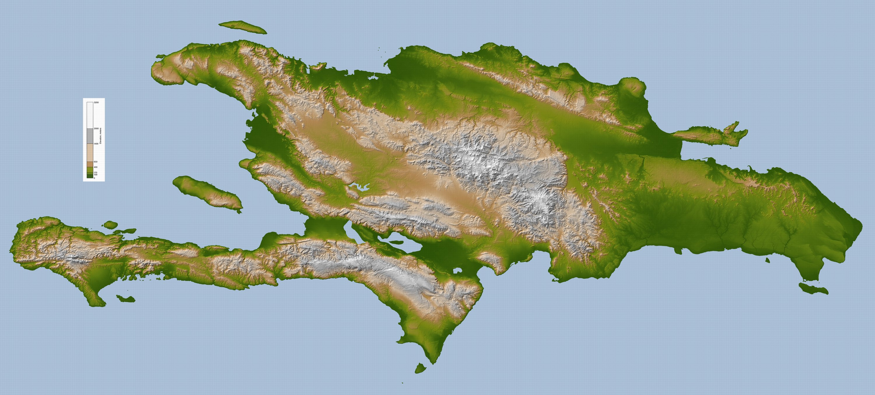
CrazyC83 wrote:It also looks like Erika is in a lake valley between two mountain ranges. It's pretty flat there until it emerges back over the ocean.
https://upload.wikimedia.org/wikipedia/ ... la_lrg.jpg
I was just looking at that...
0 likes
I HAVE ABSOLUTELY NO IDEA WHAT I'M TALKING ABOUT. PLEASE CONSULT SOMEONE WHO DOES. START WITH THE NHC. ALL POSTS ARE FOR ENTERTAINMENT PURPOSES ONLY.
-
tatertawt24
- Category 1

- Posts: 309
- Joined: Wed Oct 24, 2012 12:57 pm
Re: ATL: ERIKA - Tropical Storm - Discussion
Yeah, I'd say the microwave presentation is some kind of illusion. If it is an eyewall it's the most sudden eyewall I've ever seen develop. 
0 likes
Personal Forecast Disclaimer:
The posts in this forum are NOT official forecast and should not be used as such. They are just the opinion of the poster and may or may not be backed by sound meteorological data. They are NOT endorsed by any professional institution or storm2k.org. For official information, please refer to the NHC and NWS products.
The posts in this forum are NOT official forecast and should not be used as such. They are just the opinion of the poster and may or may not be backed by sound meteorological data. They are NOT endorsed by any professional institution or storm2k.org. For official information, please refer to the NHC and NWS products.
-
hurricanekid416
- Tropical Storm

- Posts: 179
- Joined: Wed Oct 24, 2012 2:43 pm
Can microwave lie like that?
0 likes
Personal Forecast Disclaimer:
The posts in this forum are NOT official forecast and should not be used as such. They are just the opinion of the poster and may or may not be backed by sound meteorological data. They are NOT endorsed by any professional institution or storm2k.org. For official information, please refer to the NHC and NWS products.
The posts in this forum are NOT official forecast and should not be used as such. They are just the opinion of the poster and may or may not be backed by sound meteorological data. They are NOT endorsed by any professional institution or storm2k.org. For official information, please refer to the NHC and NWS products.


Re:
hurricanekid416 wrote:Can microwave lie like that?
Obviously it must...otherwise that 11PM discussion is going to be epic
0 likes
Just like Jon Snow..."I know nothing" except what I know, and most of what I know is gathered by the fine people of the NHC
-
ozonepete
- Professional-Met
- Posts: 4743
- Joined: Mon Sep 07, 2009 3:23 pm
- Location: From Ozone Park, NYC / Now in Brooklyn, NY
Re:
TheStormExpert wrote::uarrow: There is NO WAY Erika is organized as well as microwave shows it.
Why not? The mid-level circulation of TC's often maintains itself quite well when passing over mountainous terrain. It's just that in most cases, due to higher clouds obscuring the mid-levels, we can't see the robust mid-level circulation riding along untouched as the mountains annihilate the LLC or LLCs. that's why the NHC says to focus on the mid-level swirl.
0 likes
-
drewschmaltz
- S2K Supporter
- Posts: 351
- Joined: Thu Aug 27, 2015 8:19 pm
Re: ATL: ERIKA - Tropical Storm - Discussion
Even if it isn't a COC, isn't it a lot of convection south of where NHC just fixed a COC?
0 likes
I HAVE ABSOLUTELY NO IDEA WHAT I'M TALKING ABOUT. PLEASE CONSULT SOMEONE WHO DOES. START WITH THE NHC. ALL POSTS ARE FOR ENTERTAINMENT PURPOSES ONLY.
-
Evil Jeremy

- S2K Supporter
- Posts: 5463
- Age: 32
- Joined: Mon Apr 10, 2006 2:10 pm
- Location: Los Angeles, CA
-
floridasun78
- Category 5

- Posts: 3755
- Joined: Sun May 17, 2009 10:16 pm
- Location: miami fl
Re:
spiral wrote:
That depicts almost a closed eyewall.


maybe vorticity did make better and we think because want over big mountain still their
0 likes
-
CrazyC83
- Professional-Met
- Posts: 34315
- Joined: Tue Mar 07, 2006 11:57 pm
- Location: Deep South, for the first time!
The temperatures of Lake Enriquillo are about 29C, as warm as tropical oceans. It might be playing some role...and that region is mostly wetlands, near or below sea level.
http://www.eoearth.org/view/article/152568/
http://www.eoearth.org/view/article/152568/
0 likes
-
ozonepete
- Professional-Met
- Posts: 4743
- Joined: Mon Sep 07, 2009 3:23 pm
- Location: From Ozone Park, NYC / Now in Brooklyn, NY
Re:
drezee wrote:That not a COC, that is just the structure of the thunderstorms. Just a picture in time...no more no less. Not a eyeWall or anything
It is very clearly a COC at mid to upper levels. Otherwise our microwave satellites are useless.
0 likes
Re:
drezee wrote:That not a COC, that is just the structure of the thunderstorms. Just a picture in time...no more no less. Not a eyeWall or anything
yes. otherwise this would be the most awesome 1007mb or so landfallen TC ever
0 likes
-
AutoPenalti
- Category 5
- Posts: 4091
- Age: 29
- Joined: Mon Aug 17, 2015 4:16 pm
- Location: Ft. Lauderdale, Florida
Just because it looks like an eyewall doesn't mean it is an eyewall.
Wait...
Wait...
0 likes
The posts in this forum are NOT official forecasts and should not be used as such. They are just the opinion of the poster and may or may not be backed by sound meteorological data. They are NOT endorsed by any professional institution or STORM2K. For official information, please refer to products from the NHC and NWS.
Model Runs Cheat Sheet:
GFS (5:30 AM/PM, 11:30 AM/PM)
HWRF, GFDL, UKMET, NAVGEM (6:30-8:00 AM/PM, 12:30-2:00 AM/PM)
ECMWF (1:45 AM/PM)
TCVN is a weighted averaged

Re: ATL: ERIKA - Tropical Storm - Discussion
Surface reports conclude it is NOT at the surface
0 likes
The following post is NOT an official forecast and should not be used as such. It is just the opinion of the poster and may or may not be backed by sound meteorological data. It is NOT endorsed by any professional institution including storm2k.org For Official Information please refer to the NHC and NWS products.
-
hurricanekid416
- Tropical Storm
- Posts: 179
- Joined: Wed Oct 24, 2012 2:43 pm
Thats a very vigorous mid level circulation
0 likes
Personal Forecast Disclaimer:
The posts in this forum are NOT official forecast and should not be used as such. They are just the opinion of the poster and may or may not be backed by sound meteorological data. They are NOT endorsed by any professional institution or storm2k.org. For official information, please refer to the NHC and NWS products.
The posts in this forum are NOT official forecast and should not be used as such. They are just the opinion of the poster and may or may not be backed by sound meteorological data. They are NOT endorsed by any professional institution or storm2k.org. For official information, please refer to the NHC and NWS products.
Who is online
Users browsing this forum: No registered users and 39 guests