ATL: ERIKA - Remnants - Discussion
Moderator: S2k Moderators
-
wzrgirl1

- S2K Supporter

- Posts: 1360
- Joined: Sat Sep 04, 2004 6:44 am
- Location: Pembroke Pines, Florida
Re: ATL: ERIKA - Tropical Storm - Discussion
With the forecast error between 150-250 miles in the 3-5 day time frame it is almost a sure thing that Erika will be around the vicinity of south to central Florida some time late Sunday or early Monday. The uncertainty is in the strength. She has my attention and I will be getting water and pulling out my supplies this evening just to be safe.
0 likes
Re: ATL: ERIKA - Tropical Storm - Discussion

So this is the ECMWF control run.
It had it going up into Florida, but the breaks halted due to the building ridge and was thrown out into the GOM. Hmmmmmmm.
0 likes
The posts in this forum are NOT official forecast and should not be used as such. They are just the opinion of the poster and may or may not be backed by sound meteorological data. They are NOT endorsed by any professional institution or storm2k.org. For official information, please refer to the NHC and NWS products.
-
wzrgirl1
- S2K Supporter
- Posts: 1360
- Joined: Sat Sep 04, 2004 6:44 am
- Location: Pembroke Pines, Florida
Re: ATL: ERIKA - Tropical Storm - Discussion
tgenius wrote:The local SFL media is already starting to go into overdrive. If the 11 and 5pm advisories keep Erika pointed out way it's gonna start reaching critical mass.
Agreed. One radio station was already mocking the storm. Nothing to take lightly if the forecast verifies. Because it has been 10 years, my worry is that people may react late. Everyone should cautiously check their supplies and keep one eye on Erika as she draws closer to the coast.
0 likes

-
wzrgirl1
- S2K Supporter
- Posts: 1360
- Joined: Sat Sep 04, 2004 6:44 am
- Location: Pembroke Pines, Florida
Re: ATL: ERIKA - Tropical Storm - Discussion
A slow organization is in the forecast and so she may not be at hurricane status until day 3 or 4. This is one of those watch and plan so that you don't rush at the last minute when and if she is upgraded to hurricane status. Furthermore, this can be a gentle reminder that hurricane supplies should be in check.
My worry is the gulfstream. I have lived in south florida long enough to know that the gulfstream can cause a R.I. Thank goodness for this sight where we can get the latest information. I wish more people would have the knowledge that us tropical weather lovers do.
My worry is the gulfstream. I have lived in south florida long enough to know that the gulfstream can cause a R.I. Thank goodness for this sight where we can get the latest information. I wish more people would have the knowledge that us tropical weather lovers do.
0 likes
Looks like I can finally see some outflow with Erika.
0 likes
The posts in this forum are NOT official forecast and should not be used as such. They are just the opinion of the poster and may or may not be backed by sound meteorological data. They are NOT endorsed by any professional institution or storm2k.org. For official information, please refer to the NHC and NWS products.
-
Blizzard96x

- Tropical Depression

- Posts: 84
- Joined: Wed Aug 19, 2015 4:34 am
I appreciate the useful information everyone has been posting here! I have been on several different weather forums before and I can say for a fact this forum is the best for hurricanes!
This storm is very important to me, I have a home in Jupiter, Florida. Really hoping this thing can stay weak! Thanks everyone, keep up the good work!
This storm is very important to me, I have a home in Jupiter, Florida. Really hoping this thing can stay weak! Thanks everyone, keep up the good work!
0 likes
-
HURRICANELONNY
- Category 5

- Posts: 1390
- Joined: Wed May 07, 2003 6:48 am
- Location: HOLLYWOOD.FL
Re: ATL: ERIKA - Tropical Storm - Discussion
One of these times I'm going to be wrong. Anytime the cone is on S. Fl. this far out. We get nothing. I hope the streak continues but we do need rain. Especially near the coast. 
0 likes
hurricanelonny
-
tolakram
- Admin

- Posts: 20179
- Age: 62
- Joined: Sun Aug 27, 2006 8:23 pm
- Location: Florence, KY (name is Mark)
Re: ATL: ERIKA - Tropical Storm - Discussion
0 likes
M a r k
- - - - -
Join us in chat: Storm2K Chatroom Invite. Android and IOS apps also available.
The posts in this forum are NOT official forecasts and should not be used as such. Posts are NOT endorsed by any professional institution or STORM2K.org. For official information and forecasts, please refer to NHC and NWS products.
-
GeneratorPower

- S2K Supporter
- Posts: 1648
- Age: 46
- Joined: Sun Dec 18, 2005 11:48 pm
- Location: Huntsville, AL
Re: ATL: ERIKA - Tropical Storm - Discussion
The AF center fix is right under the convection.
0 likes
-
tropicwatch

- Category 5
- Posts: 3426
- Age: 62
- Joined: Sat Jun 02, 2007 10:01 am
- Location: Panama City Florida
- Contact:
HH has had several surface wind readings above 50mph.
0 likes
Tropicwatch
Agnes 72', Eloise 75, Elena 85', Kate 85', Charley 86', Florence 88', Beryl 94', Dean 95', Erin 95', Opal 95', Earl 98', Georges 98', Ivan 2004', Arlene 2005', Dennis 2005', Ida 2009' Debby 2012' Irma 2017' Michael 2018'
Agnes 72', Eloise 75, Elena 85', Kate 85', Charley 86', Florence 88', Beryl 94', Dean 95', Erin 95', Opal 95', Earl 98', Georges 98', Ivan 2004', Arlene 2005', Dennis 2005', Ida 2009' Debby 2012' Irma 2017' Michael 2018'
Re: Re:
spiral wrote:NDG wrote:Unflagged 42 knots at surface by SFMR just found by AF recon.
110330 1554N 05610W 8434 01552 0079 +180 +103 207017 018 042 000 00
Flight level avg so far is about 18kts.
Incorrect, AF Recon has had 36+ knot winds at flight level.
0 likes
Re: ATL: ERIKA - Tropical Storm - Discussion
GeneratorPower wrote:The AF center fix is right under the convection.
But under the northern edge, not in the center of the convection.
0 likes
-
jlauderdal
- S2K Supporter
- Posts: 7240
- Joined: Wed May 19, 2004 5:46 am
- Location: NE Fort Lauderdale
- Contact:
Re: ATL: ERIKA - Tropical Storm - Discussion
HURRICANELONNY wrote:One of these times I'm going to be wrong. Anytime the cone is on S. Fl. this far out. We get nothing. I hope the streak continues but we do need rain. Especially near the coast.
its going to end one of these days but until then the trend is your friend as well as the error in the track forecasting
0 likes
Recon is finding plenty of TS force winds to the east of the COC, both at flight level and at the surface.
114030 1556N 05523W 8429 01592 0131 +160 +090 151037 037 039 000 00
114100 1558N 05523W 8428 01592 0131 +160 +090 152039 040 038 000 03
114130 1600N 05524W 8432 01587 0129 +162 +090 155041 041 038 000 00
114200 1602N 05524W 8430 01590 0129 +162 +090 155041 042 035 000 00
114030 1556N 05523W 8429 01592 0131 +160 +090 151037 037 039 000 00
114100 1558N 05523W 8428 01592 0131 +160 +090 152039 040 038 000 03
114130 1600N 05524W 8432 01587 0129 +162 +090 155041 041 038 000 00
114200 1602N 05524W 8430 01590 0129 +162 +090 155041 042 035 000 00
0 likes
-
Blown Away

- S2K Supporter
- Posts: 10253
- Joined: Wed May 26, 2004 6:17 am
Re: ATL: ERIKA - Tropical Storm - Discussion

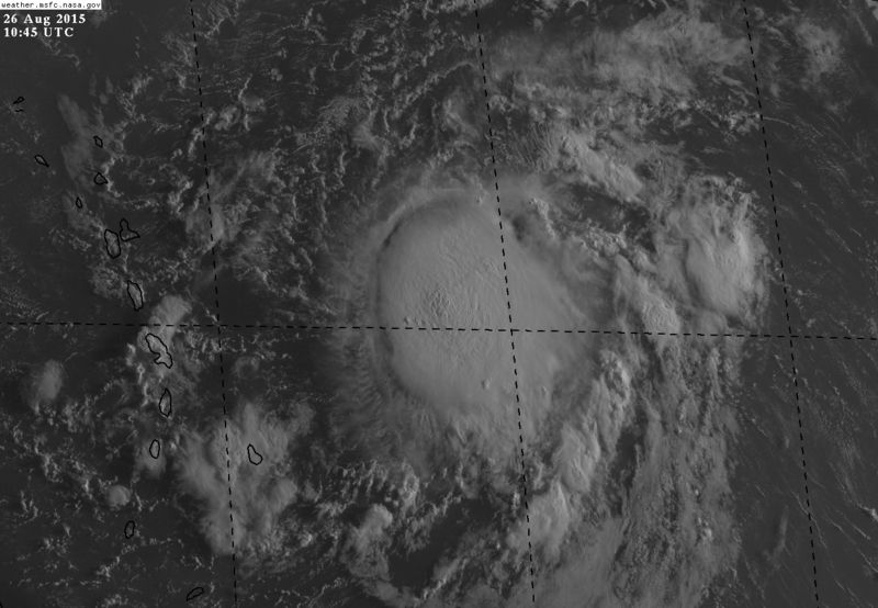
Erika a little better this morning...
0 likes
Hurricane Eye Experience: David 79, Irene 99, Frances 04, Jeanne 04, Wilma 05… Hurricane Brush Experience: Andrew 92, Erin 95, Floyd 99, Matthew 16, Irma 17, Ian 22, Nicole 22…
-
Gustywind

- Category 5
- Posts: 12334
- Joined: Mon Sep 03, 2007 7:29 am
- Location: Baie-Mahault, GUADELOUPE
000
WTNT35 KNHC 261153
TCPAT5
BULLETIN
TROPICAL STORM ERIKA INTERMEDIATE ADVISORY NUMBER 6A
NWS NATIONAL HURRICANE CENTER MIAMI FL AL052015
800 AM AST WED AUG 26 2015
...HURRICANE HUNTER AIRCRAFT FINDS ERIKA SLIGHTLY STRONGER...
SUMMARY OF 800 AM AST...1200 UTC...INFORMATION
----------------------------------------------
LOCATION...16.2N 56.8W
ABOUT 335 MI...540 KM E OF ANTIGUA
MAXIMUM SUSTAINED WINDS...45 MPH...75 KM/H
PRESENT MOVEMENT...W OR 280 DEGREES AT 17 MPH...28 KM/H
MINIMUM CENTRAL PRESSURE...1005 MB...29.68 INCHES
WATCHES AND WARNINGS
--------------------
CHANGES WITH THIS ADVISORY:
None.
SUMMARY OF WATCHES AND WARNINGS IN EFFECT:
A Tropical Storm Warning is in effect for...
* Anguilla
* Saba and St. Eustatius
* St. Maarten
* Montserrat
* Antigua and Barbuda
* St. Kitts and Nevis
* Puerto Rico
* Vieques
* Culebra
* U.S. Virgin Islands
* British Virgin Islands
A Tropical Storm Watch is in effect for...
* Guadeloupe
* St. Martin
* St. Barthelemy
A Tropical Storm Warning means that tropical storm conditions are
expected somewhere within the warning area, generally within 36
hours.
A Tropical Storm Watch means that tropical storm conditions are
possible within the watch area, generally within 48 hours.
For storm information specific to your area in the United States,
including possible inland watches and warnings, please monitor
products issued by your local National Weather Service forecast
office. For storm information specific to your area outside the
United States, please monitor products issued by your national
meteorological service.
0 likes
-
invest man
- Tropical Storm

- Posts: 209
- Joined: Sun Aug 17, 2008 8:12 pm
Just noticed the increase in mph to 45. I also observed two other things. #1 the center is now under the blob albeit barely on the nw side & # 2 and more important to intensification, it appears to be slowing down now at 15 kt. This would all lead me to think this may be getting ready to strengthen sooner than anticipated. IM
0 likes
As mentioned in the NHC discussion of Danny a few days ago, there appears to be a ULL developing over eastern Cuba this morning - that's a significant factor in Ericka's future development:
http://www.goes.noaa.gov/HURRLOOPS/huwvloop.html
http://www.goes.noaa.gov/HURRLOOPS/huwvloop.html
0 likes
Who is online
Users browsing this forum: No registered users and 74 guests