ATL: 90L - ERIKA Remnants - Models

Moderator: S2k Moderators

Message
Author
NCSTORMMAN

Re: ATL: ERIKA - Models

#461 Postby NCSTORMMAN » Tue Aug 25, 2015 9:16 am

hohnywx wrote:


Not here and not in many years. Models are being fed crap and spit out crap. You want to see a US threat you need to be focusing on China not the tropics.[/quote]

Can you stop already? This is ridiculous.

The mets have stated that they expect it to degenerate and then regenerate in the Bahamas. It can happen. Enough.[/quote]

Not in my opinion and we shall see eh?
0 likes   

User avatar
Bocadude85
Category 5
Category 5
Posts: 2991
Age: 38
Joined: Mon Apr 18, 2005 2:20 pm
Location: Honolulu,Hi

Re: ATL: ERIKA - Models

#462 Postby Bocadude85 » Tue Aug 25, 2015 9:17 am

NCSTORMMAN wrote:
hohnywx wrote:


Not here and not in many years. Models are being fed crap and spit out crap. You want to see a US threat you need to be focusing on China not the tropics.


Can you stop already? This is ridiculous.

The mets have stated that they expect it to degenerate and then regenerate in the Bahamas. It can happen. Enough.[/quote]

Not in my opinion and we shall see eh?[/quote]

This has nothing to do with models. Post your opinions on Erika in the discussion thread.
0 likes   

NCSTORMMAN

Re: ATL: ERIKA - Models

#463 Postby NCSTORMMAN » Tue Aug 25, 2015 9:18 am

Bocadude85 wrote:
NCSTORMMAN wrote:
hohnywx wrote:


Not here and not in many years. Models are being fed crap and spit out crap. You want to see a US threat you need to be focusing on China not the tropics.


Can you stop already? This is ridiculous.

The mets have stated that they expect it to degenerate and then regenerate in the Bahamas. It can happen. Enough.


Not in my opinion and we shall see eh?[/quote]

This has nothing to do with models. Post your opinions on Erika in the discussion thread.[/quote]

It was my opinion that the models will have nothing to strengthen. So, that does deal with the models.
0 likes   

User avatar
chaser1
S2K Supporter
S2K Supporter
Posts: 5464
Age: 64
Joined: Sat Oct 15, 2005 5:59 pm
Location: Longwood, Fl

Re:

#464 Postby chaser1 » Tue Aug 25, 2015 9:21 am

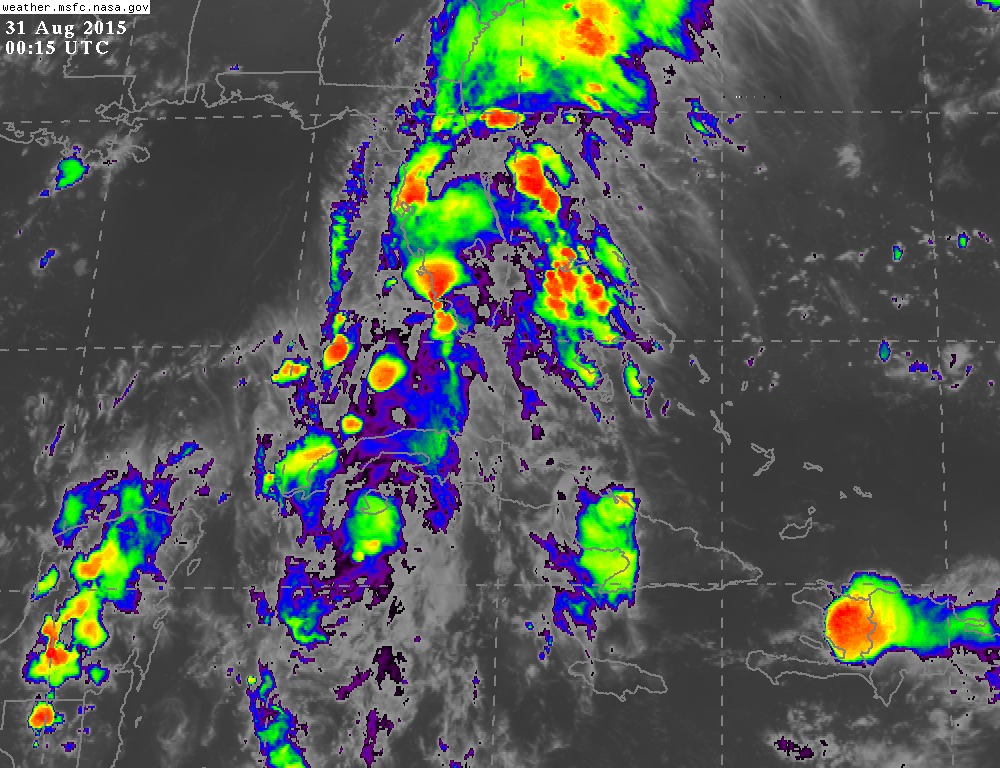
Weatherboy1 wrote:Well, this is definitely interesting. Erika doesn't look so hot on satellite this morning ... but obviously more models are cranking her up toward the end of the 5-6 day forecast window. I've seen a lot of storms approaching FL from the general area Erika is progged to approach - and ultimately curve away at the last minute. So given A) current lousy appearance and B) the recurve factor some models are showing and past experience shows is likely, I'm not getting overly concerned here YET. But definitely worth watching to see how trends unfold in the next day or two.

Just the opinion of a semi-educated amateur, listen to the experts as always :)


Great point regarding model fluctuation, but even better point with regard to how Erika presently appears. Modeling has improved over the years and NHC has especially performed better and better with regard to track forecast and margin of error. Personally, I don't pay too much attention to the models quite yet, because while they may fairly accurately be displaying the near to mid term steering influences, what they cannot as effectively forecast is how well or how fast/slowly will Erika develop. That is why some models show a very weak system and some a strong one. The point here is that as the various models initiate Erika for each run, the behavior of each run may be inconsistent based on how developed (or less developed) that Erika continues to become. Even now, the storm appears not very well organized and seems to be moving westward (or just North of due west). If it remains weaker than anticipated, than it wouldn't be unreasonable for it to continue to track more westward with the surface flow (well BAMS to BAMM perhaps). Even now, the NHC forecast has Erika at 15.2 N at 1800Z today, and at 16.0 N by 0600Z tonight (well, technically tomm. a.m.) If Erika were to track south of those points, then adjustments to track would have to ensue. If that occurs, the potential for land interaction changes and suddenly the models might appear to be hopping all over the place, but in fact the variable that is not yet particularly consistent, is the storm itself.

Based on all that, I think it makes sense to wait and see if Erika truly starts to become a bit more vertically developed today through tomm. That's when I begin to pay a bit more attention to how the global models evolve and/or the nuances regarding speed of the storm's forward motion verses downstream digging troughs, cut-off lows, or building ridges may play out.
0 likes   
Andy D

(For official information, please refer to the NHC and NWS products.)

hohnywx
Category 2
Category 2
Posts: 508
Age: 34
Joined: Sun Jul 19, 2009 8:34 pm
Location: Hastings-on-Hudson, NY

#465 Postby hohnywx » Tue Aug 25, 2015 9:23 am

http://www.nymetroweather.com/2015/08/2 ... next-week/

The ECMWF Ensembles are forecasting a >50% chance of a landfalling TC next week.
0 likes   

HurriGuy
S2K Supporter
S2K Supporter
Posts: 734
Joined: Thu Aug 15, 2013 8:43 pm
Location: Prairieville, LA

#466 Postby HurriGuy » Tue Aug 25, 2015 9:25 am

I am pretty sure the center is being exposed to the north. No thunderstorms firing off.
0 likes   
The posts in this forum are NOT official forecast and should not be used as such. They are just the opinion of the poster and may or may not be backed by sound meteorological data. They are NOT endorsed by any professional institution or storm2k.org. For official information, please refer to the NHC and NWS products.

HurriGuy
S2K Supporter
S2K Supporter
Posts: 734
Joined: Thu Aug 15, 2013 8:43 pm
Location: Prairieville, LA

Re: ATL: ERIKA - Models

#467 Postby HurriGuy » Tue Aug 25, 2015 9:29 am

Image
0 likes   
The posts in this forum are NOT official forecast and should not be used as such. They are just the opinion of the poster and may or may not be backed by sound meteorological data. They are NOT endorsed by any professional institution or storm2k.org. For official information, please refer to the NHC and NWS products.

User avatar
tropicwatch
Category 5
Category 5
Posts: 3383
Age: 61
Joined: Sat Jun 02, 2007 10:01 am
Location: Panama City Florida
Contact:

#468 Postby tropicwatch » Tue Aug 25, 2015 9:41 am

Gonzo is almost there and convection is building again.

Image
0 likes   
Tropicwatch


Agnes 72', Eloise 75, Elena 85', Kate 85', Charley 86', Florence 88', Beryl 94', Dean 95', Erin 95', Opal 95', Earl 98', Georges 98', Ivan 2004', Arlene 2005', Dennis 2005', Ida 2009' Debby 2012' Irma 2017' Michael 2018'

HurriGuy
S2K Supporter
S2K Supporter
Posts: 734
Joined: Thu Aug 15, 2013 8:43 pm
Location: Prairieville, LA

Re: ATL: ERIKA - Models

#469 Postby HurriGuy » Tue Aug 25, 2015 9:43 am

0 likes   
The posts in this forum are NOT official forecast and should not be used as such. They are just the opinion of the poster and may or may not be backed by sound meteorological data. They are NOT endorsed by any professional institution or storm2k.org. For official information, please refer to the NHC and NWS products.

User avatar
tropicwatch
Category 5
Category 5
Posts: 3383
Age: 61
Joined: Sat Jun 02, 2007 10:01 am
Location: Panama City Florida
Contact:

#470 Postby tropicwatch » Tue Aug 25, 2015 9:44 am

:uarrow: Last couple of frames.
0 likes   
Tropicwatch


Agnes 72', Eloise 75, Elena 85', Kate 85', Charley 86', Florence 88', Beryl 94', Dean 95', Erin 95', Opal 95', Earl 98', Georges 98', Ivan 2004', Arlene 2005', Dennis 2005', Ida 2009' Debby 2012' Irma 2017' Michael 2018'

stormlover2013

Re: ATL: ERIKA - Models

#471 Postby stormlover2013 » Tue Aug 25, 2015 9:45 am

sucker is looking bad and smaller and smaller
0 likes   

User avatar
Extratropical94
Professional-Met
Professional-Met
Posts: 3538
Age: 30
Joined: Wed Oct 20, 2010 6:36 am
Location: Hamburg, Germany
Contact:

Re: ATL: ERIKA - Models

#472 Postby Extratropical94 » Tue Aug 25, 2015 9:45 am


Near 14.5N 50.5W in the last frame, there's a tower that is shooting.
0 likes   
54° 11' 59'' N, 9° 9' 20'' E
Boomer Sooner!
Go Broncos! Go Cards! Go Niners!
- Daniel

WilmingtonSandbar
S2K Supporter
S2K Supporter
Posts: 505
Joined: Sun Aug 29, 2010 12:11 pm
Location: Southport, NC

Re: ATL: ERIKA - Models

#473 Postby WilmingtonSandbar » Tue Aug 25, 2015 9:48 am

Guys, this is the Models thread. Conversations about recon or general discussions about convection need to be taken to their respective threads please.
0 likes   
Diana X2 (look it up), Bertha, Fran, Bonnie, Floyd, Dennis, Charley, Ophelia, Ernesto, Irene, Matthew, And Florence

User avatar
Ntxw
Storm2k Moderator
Storm2k Moderator
Posts: 22785
Joined: Wed Oct 21, 2009 6:34 pm
Location: DFW, Texas

#474 Postby Ntxw » Tue Aug 25, 2015 9:48 am

Guys, lets keep our cool for a productive discussion. Also this should be about models and model runs, any personal thoughts/analysis or current condition of Erika should go in the discussion thread.

Thanks
0 likes   
The above post and any post by Ntxw is NOT an official forecast and should not be used as such. It is just the opinion of the poster and may or may not be backed by sound meteorological data. It is NOT endorsed by any professional institution including Storm2k. For official information, please refer to NWS products.

  Help support Storm2K!
Help Support Storm2K

HurriGuy
S2K Supporter
S2K Supporter
Posts: 734
Joined: Thu Aug 15, 2013 8:43 pm
Location: Prairieville, LA

Re: ATL: ERIKA - Models

#475 Postby HurriGuy » Tue Aug 25, 2015 9:49 am

Extratropical94 wrote:


Near 14.5N 50.5W in the last frame, there's a tower that is shooting.


I am sure that puny re-burst of convection is besides the point, the center is almost completely exposed.
0 likes   
The posts in this forum are NOT official forecast and should not be used as such. They are just the opinion of the poster and may or may not be backed by sound meteorological data. They are NOT endorsed by any professional institution or storm2k.org. For official information, please refer to the NHC and NWS products.

User avatar
tropicwatch
Category 5
Category 5
Posts: 3383
Age: 61
Joined: Sat Jun 02, 2007 10:01 am
Location: Panama City Florida
Contact:

#476 Postby tropicwatch » Tue Aug 25, 2015 9:50 am

oops, sorry. :oops:
0 likes   
Tropicwatch


Agnes 72', Eloise 75, Elena 85', Kate 85', Charley 86', Florence 88', Beryl 94', Dean 95', Erin 95', Opal 95', Earl 98', Georges 98', Ivan 2004', Arlene 2005', Dennis 2005', Ida 2009' Debby 2012' Irma 2017' Michael 2018'

User avatar
chaser1
S2K Supporter
S2K Supporter
Posts: 5464
Age: 64
Joined: Sat Oct 15, 2005 5:59 pm
Location: Longwood, Fl

Re: ATL: ERIKA - Models

#477 Postby chaser1 » Tue Aug 25, 2015 10:12 am

I think that at this time we are kinda stuck in a bit of a "sweet spot" where two different threads cannot help but become a little intertwined. Sure, while this is the model thread and many here (myself included) are curious about the longer term prospects for Erika's track and points potentially threatened, we still have a very marginal T.S. that has yet to establish a well organized vertical structure. Therefore in its present state, even near term motion and intensity remain somewhat questionable and present motion would appear to still be primarily influenced by the more shallow surface trades. This can largely impact overall downstream model accuracy as it applies to storm track and potentially intensity as well. For the moment its difficult to discuss any one model or model consensus in a vacuum, while ignoring the fact that Erika might still not be following her own script. So yes, discussions here should remain "model" focused however those conversations and opinions will probably continue to be driven by Erika's potential struggles to develop during the next 24 hours or so (or up to the point where she becomes at least a little more organized)
0 likes   
Andy D

(For official information, please refer to the NHC and NWS products.)

User avatar
Bocadude85
Category 5
Category 5
Posts: 2991
Age: 38
Joined: Mon Apr 18, 2005 2:20 pm
Location: Honolulu,Hi

Re: ATL: ERIKA - Models

#478 Postby Bocadude85 » Tue Aug 25, 2015 10:38 am

12z GFS is running
0 likes   

User avatar
Rgv20
S2K Supporter
S2K Supporter
Posts: 2466
Age: 38
Joined: Wed Jan 05, 2011 5:42 pm
Location: Edinburg/McAllen Tx

#479 Postby Rgv20 » Tue Aug 25, 2015 10:39 am

1 stray 0z ECMWF Ensemble Member has Ericka just north of the Yucatan Peninsula by day 10..
0 likes   
The following post is NOT an official forecast and should not be used as such. It is just the opinion of the poster and may or may not be backed by sound meteorological data. It is NOT endorsed by any professional institution including storm2k.org For Official Information please refer to the NHC and NWS products.

User avatar
SouthFLTropics
Category 5
Category 5
Posts: 4236
Age: 50
Joined: Thu Aug 14, 2003 8:04 am
Location: Port St. Lucie, Florida

Re: ATL: ERIKA - Models

#480 Postby SouthFLTropics » Tue Aug 25, 2015 10:59 am

The question of the hour...Will the GFS jump on board with the Euro and start to show significant development in the Bahamas...Stay tuned...The answer is coming shortly...
0 likes   
Fourth Generation Florida Native

Personal Storm History: David 79, Andrew 92, Erin 95, Floyd 99, Irene 99, Frances 04, Jeanne 04, Wilma 05, Matthew 16, Irma 17, Ian 22, Nicole 22, Milton 24


Return to “2015”

Who is online

Users browsing this forum: No registered users and 2 guests