ATL: DANNY - Remnants - Discussion
Moderator: S2k Moderators


Re: ATL: DANNY - Hurricane- Discussion
Accidentally woke up at 4:40 am, checking on this storm. Continue to respectfully disagree with the NHC on intensity, would guess it is around 90 knots with that tiny eye which has been visible for 6 hours.
0 likes

Re: ATL: DANNY - Hurricane- Discussion
N2FSU wrote:
Not as symmetrical this morning.

Interestingly, you notice that NNE/SSW tilt to Danny's overall convective mass? I'm thinking that this orientation is being caused by the subtle increase in the southwesterly flow which Danny is slowly marching towards and into. Here is where I think the result might be another temporary little jump north as an effort to maintain an aligned core given the deep layer flow wanting to take Danny on a general 285 heading, while the upper level winds are tending to push Danny's convective tops more pole-ward. Often times the result is an apparent "stair-step" motion where the storms low level center attempts to remain co-located with its vertical core "vacuum of air", as such would be the point of lowest pressure still attempting to be induced.
0 likes
Andy D
(For official information, please refer to the NHC and NWS products.)
(For official information, please refer to the NHC and NWS products.)


Re: ATL: DANNY - Hurricane- Discussion
Only other observation here, is that NHC is depicting a faster motion to occur by tomm., as a result of the trough (associated with 97L?) to soon pull north and be absorbed into the westerlies. A larger lazy 200mb low is also depicted north of Danny and temporarily eroding the western edge of the mid-Atlantic ridge. Yet, as i look at both the 500mb and the 200mb level forecasts, I'm just not seeing any ridging building back in and over Danny for at least 60 or so hours. I"m probably wrong here, but it just seems to me that the maintained near term weakness in the ridge will continue for 2-3 more days. That, along with any slight tendency for Danny to "jerk" northward to keep up with its convective core which is increasingly being affected by the increase in southwesterly upper flow, and I cant help but think that Danny might begin to gain a bit more latitude that NHC was projecting. Now, assuming that Danny maintains a decent vertical integrity for one or two more days, than I wouldn't imagine that we'd be seeing a more westward motion quite yet, at least not until Danny has become noticeably more of a shallow system and then of course tend to move more in line with the surface flow. That entire visual though, might only make for a few degree difference in projected track, but that could be significant in terms of whether Danny might then live to see some re-intensification downstream perhaps.
0 likes
Andy D
(For official information, please refer to the NHC and NWS products.)
(For official information, please refer to the NHC and NWS products.)
-
Gustywind

- Category 5

- Posts: 12334
- Joined: Mon Sep 03, 2007 7:29 am
- Location: Baie-Mahault, GUADELOUPE
000
WTNT34 KNHC 210833
TCPAT4
BULLETIN
HURRICANE DANNY ADVISORY NUMBER 12
NWS NATIONAL HURRICANE CENTER MIAMI FL AL042015
500 AM AST FRI AUG 21 2015
...DANNY STRENGTHENS A LITTLE...
SUMMARY OF 500 AM AST...0900 UTC...INFORMATION
----------------------------------------------
LOCATION...13.7N 47.4W
ABOUT 985 MI...1590 KM ESE OF THE LEEWARD ISLANDS
MAXIMUM SUSTAINED WINDS...85 MPH...140 KM/H
PRESENT MOVEMENT...WNW OR 290 DEGREES AT 10 MPH...17 KM/H
MINIMUM CENTRAL PRESSURE...987 MB...29.15 INCHES
WATCHES AND WARNINGS
--------------------
There are no coastal watches or warnings in effect.
Interests in the Leeward Islands should monitor the progress of
Danny.
0 likes
Re:
spiral wrote:Systems tilt to the west that allows intensification.
Yep, however Danny appears to at least be temporarily tilted more towards the North Pole LOL. Yet in spite of this season, El Nino, Saharan Dust, or the dreaded Texas Heat Ridge... you gotta admit that Danny (at least for the moment) continues to present an impressive nasty inner core and still remains an impressive, albeit very small hurricane.
0 likes
Andy D
(For official information, please refer to the NHC and NWS products.)
(For official information, please refer to the NHC and NWS products.)
-
Gustywind
- Category 5
- Posts: 12334
- Joined: Mon Sep 03, 2007 7:29 am
- Location: Baie-Mahault, GUADELOUPE
TROPICAL CYCLONE ALERT STATEMENT
WHCA31 TAPA
HURRICANE DANNY ALERT STATEMENT
ANTIGUA AND BARBUDA METEOROLOGICAL SERVICES
5:10 AM ECT FRI, AUG 21, 2015
THIS IS FOR THE LEEWARD ISLANDS AND THE BRITISH VIRGIN ISLANDS
...DANNY STRENGTHENS A LITTLE...
AT 5 AM ECT OR 0900Z THE EYE OF HURRICANE DANNY WAS LOCATED NEAR LATITUDE 13.7 NORTH, LONGITUDE 47.4 WEST OR ABOUT 985 MILES ESE OF THE LEEWARD ISLANDS.
DANNY IS MOVING TOWARD THE WEST-NORTHWEST AT 10 MPH, AND THIS GENERAL MOTION IS EXPECTED TO CONTINUE DURING THE NEXT DAY OR SO. A TURN TOWARD THE WEST IS FORECAST BY SATURDAY NIGHT.
MAXIMUM SUSTAINED WINDS HAVE INCREASED TO NEAR 85 MPH WITH HIGHER GUSTS. SOME STRENGTHENING IN POSSIBLE TODAY, BUT DANNY SHOULD BEGIN TO WEAKEN ON SATURDAY.
DANNY IS A TINY HURRICANE. HURRICANE FORCE WINDS EXTEND OUTWARD UP TO 10 MILES FROM THE CENTRE AND TROPICAL STORM FORCE WINDS EXTEND OUTWARD TO 60 MILES.
THE ESTIMATED MINIMUM CENTRAL PRESSURE IS 987 MB OR 29.15 INCHES.
ON ITS PRESENT TRACK, DANNY WILL BE PASSING THROUGH THE LEEWARD ISLANDS ON MONDAY.
A WATCH COULD COME INTO EFFECT LATER TODAY FOLLOWED BY A WARNING DURING THE NEXT 36 HOURS. RESIDENTS SHOULD START IMPLEMENTING THE PORTION OF THEIR HURRICANE PLAN THAT MAY REQUIRE MORE THAN 48 HOURS TO COMPLETE. OTHERWISE, RESIDENTS SHOULD STAND READY TO EXECUTE THEIR STORM/HURRICANE PLAN IF A WATCH IS ISSUED TODAY.
FORECASTER BERNELL SIMON
0 likes
-
Gustywind
- Category 5
- Posts: 12334
- Joined: Mon Sep 03, 2007 7:29 am
- Location: Baie-Mahault, GUADELOUPE
DATE/TIME LAT LON CLASSIFICATION STORM
21/0545 UTC 13.5N 46.9W T4.5/4.5 DANNY
20/2345 UTC 13.2N 46.0W T4.5/4.5 DANNY
20/1745 UTC 12.7N 45.3W T4.0/4.0 DANNY
20/1145 UTC 12.4N 44.2W T3.0/3.0 DANNY
20/0545 UTC 12.0N 43.1W T2.5/3.0 DANNY
19/2345 UTC 11.9N 42.3W T3.0/3.0 DANNY
19/1745 UTC 11.6N 41.4W T2.5/2.5 DANNY
19/1145 UTC 11.0N 40.6W T2.5/2.5 DANNY
19/0545 UTC 11.3N 39.2W T2.5/2.5 DANNY
18/2345 UTC 11.0N 38.3W T2.5/2.5 DANNY
18/1745 UTC 11.1N 37.0W T2.0/2.0 04L
18/1145 UTC 10.2N 35.9W T2.0/2.0 96L
18/0545 UTC 9.5N 34.4W T1.5/1.5 96L
18/0000 UTC 9.3N 33.2W T1.0/1.0 96L
0 likes

Re: ATL: DANNY - Hurricane- Discussion
Looks like Danny is going to make cat 2 if not already there.
Only thing I see that wasn't mentioned in the official forecast is an expansion of the ridging Danny is embedded in.
The shear from the southwest ahead of Danny is deflecting around the northwestern periphery of the building high pressure envelope.
That envelope appears to be expanding westward past 57 degrees longitude.
Doesn't give the shear much time to penetrate Danny's circulation before the islands.
Be interesting to see what the models do with a cat 2 storm later today.
Last edited by Nimbus on Fri Aug 21, 2015 5:42 am, edited 1 time in total.
0 likes
-
Gustywind
- Category 5
- Posts: 12334
- Joined: Mon Sep 03, 2007 7:29 am
- Location: Baie-Mahault, GUADELOUPE
Here is the latest weather forecast given our Pro Mets of Meteo-France Guadeloupe.
Friday, August 21, 2015 05AM
 http://www.meteofrance.gp/integration/s ... dirrag.pdf
Release of cyclonic activity
Characteristics of the hurricane of category 1 DANNY, on Friday, August 21, 2015 at 09:00 UTC 05AM
Position: 13.7 N 47.4W.
The central pressure: 987hPa.
Max winds: 140 km/h, gusts 170 km/h.
The hurricane, which continues to intensify today, is still more than 1450 km east of the Caribbean Arc and moves on a track globally oriented towards the wnw at about 17 km/h.
This trajectory is expected to continue for the next few days.
For the moment no Hurricane danger is expected on the Lesser Antilles until Saturday, but on this possible trajectory, this system would represent a threat to the Caribbean arc Sunday or Monday.
The uncertainty (over 300 km ) is however large enough , both of them :future path and the intensity of DANNY at the approach of the West Indies.
The North of the Lesser Antilles (including Guadeloupe and Northern Islands) seems the region the most exposed but a trajectory also more closer to Martinique cannot be denied.
Weather conditions coming from Sunday on Martinique, Guadeloupe and the Northern Islands are therefore strongly conditioned by the future of DANNY.
Friday, August 21, 2015 05AM
Release of cyclonic activity
Characteristics of the hurricane of category 1 DANNY, on Friday, August 21, 2015 at 09:00 UTC 05AM
Position: 13.7 N 47.4W.
The central pressure: 987hPa.
Max winds: 140 km/h, gusts 170 km/h.
The hurricane, which continues to intensify today, is still more than 1450 km east of the Caribbean Arc and moves on a track globally oriented towards the wnw at about 17 km/h.
This trajectory is expected to continue for the next few days.
For the moment no Hurricane danger is expected on the Lesser Antilles until Saturday, but on this possible trajectory, this system would represent a threat to the Caribbean arc Sunday or Monday.
The uncertainty (over 300 km ) is however large enough , both of them :future path and the intensity of DANNY at the approach of the West Indies.
The North of the Lesser Antilles (including Guadeloupe and Northern Islands) seems the region the most exposed but a trajectory also more closer to Martinique cannot be denied.
Weather conditions coming from Sunday on Martinique, Guadeloupe and the Northern Islands are therefore strongly conditioned by the future of DANNY.
0 likes
-
northjaxpro

- S2K Supporter

- Posts: 8900
- Joined: Mon Sep 27, 2010 11:21 am
- Location: Jacksonville, FL
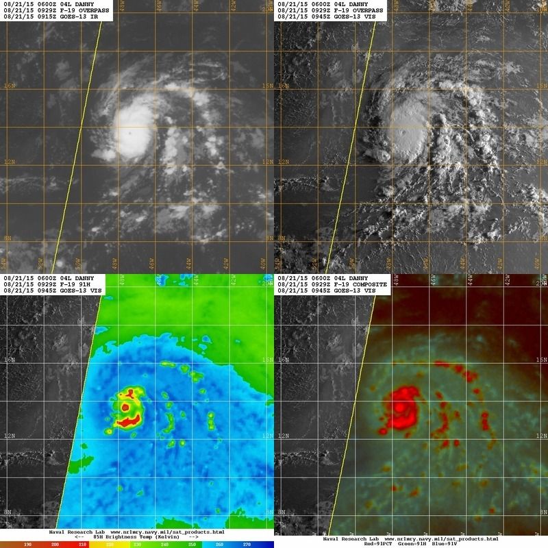
Good morning everyone. For right now, Danny is still an intensifying tropical cyclone. The beautiful pinhole eye has maintained through the overnight and the inner core is still very impressive for this storm. Danny still has about 18-24 hours of reasonably favorable conditions to strengthen a bit more today before the southwesterly shear really impacts the cyclone. As I went to sleep at around 1 a.m. I thought Danny was at least at 85 kts based on satellite presentation. Right now, I would still think it is at least that, maybe possibly at 90 kts, and it could be stronger than that currently. Wish Recon was in there right now because with all due respect to the experts at NHC, Danny is stronger than their conservative 75kt estimate currently. Danny may be peaking out now in intensity and by the time Recon gets in there this afternoon, the cyclone probably will have maxed out in intensity. Fascinating tracking this tiny but well developed hurricane this week though.
Nice
Edit: I will even mention that it is a chance Danny could approach Cat 3 strength before bottoming out. That is how impressive the storm is intensifying imo since last evening and how I think NHC is drastically underestimating how strong Danny is currently.
Nice
Edit: I will even mention that it is a chance Danny could approach Cat 3 strength before bottoming out. That is how impressive the storm is intensifying imo since last evening and how I think NHC is drastically underestimating how strong Danny is currently.
0 likes
NEVER, EVER SAY NEVER in the tropics and weather in general, and most importantly, with life itself!!
________________________________________________________________________________________
Fay 2008 Beryl 2012 Debby 2012 Colin 2016 Hermine 2016 Julia 2016 Matthew 2016 Irma 2017 Dorian 2019
________________________________________________________________________________________
Fay 2008 Beryl 2012 Debby 2012 Colin 2016 Hermine 2016 Julia 2016 Matthew 2016 Irma 2017 Dorian 2019
-
cycloneye

- Admin

- Posts: 148738
- Age: 69
- Joined: Thu Oct 10, 2002 10:54 am
- Location: San Juan, Puerto Rico
Re: ATL: DANNY - Hurricane- Discussion
Michael Ventrice @MJVentrice · 22m22 minutes ago
Wow Danny is looking even better this morning; nice ring of lower brightness temperatures around the eye wall
Wow Danny is looking even better this morning; nice ring of lower brightness temperatures around the eye wall
0 likes
Visit the Caribbean-Central America Weather Thread where you can find at first post web cams,radars
and observations from Caribbean basin members Click Here
and observations from Caribbean basin members Click Here
-
Gustywind
- Category 5
- Posts: 12334
- Joined: Mon Sep 03, 2007 7:29 am
- Location: Baie-Mahault, GUADELOUPE
TROPICAL WEATHER DISCUSSION
NWS NATIONAL HURRICANE CENTER MIAMI FL
805 AM EDT FRI AUG 21 2015
THE CENTER OF HURRICANE DANNY AT 21/0900 UTC IS NEAR 13.7N
47.4W...OR 840 NM TO THE EAST OF THE WINDWARD ISLANDS...MOVING
WEST-NORTHWESTWARD...OR 290 DEGREES...09 KNOTS. THE ESTIMATED
MINIMUM CENTRAL PRESSURE IS 987 MB. THE MAXIMUM SUSTAINED WIND
SPEEDS ARE 75 KNOTS WITH GUSTS TO 90 KNOTS. CONVECTIVE
PRECIPITATION...NUMEROUS STRONG WITHIN A RADIUS OF 60 NM OF THE
CENTER IN THE EASTERN SEMICIRCLE...AND WITHIN A RADIUS OF 30 NM
TO 60 NM OF THE CENTER IN THE WESTERN SEMICIRCLE. ISOLATED
MODERATE ELSEWHERE WITHIN A RADIUS OF 285 NM OF THE CENTER IN
THE EASTERN SEMICIRCLE...AND ELSEWHERE WITHIN A RADIUS OF 180 NM
OF THE CENTER IN THE WESTERN SEMICIRCLE. PUBLIC ADVISORIES ABOUT
HURRICANE DANNY ARE BEING ISSUED UNDER WMO HEADER WTNT34 KNHC
AND UNDER AWIPS HEADER MIATCPAT4. FORECAST/ADVISORIES ABOUT
HURRICANE DANNY ARE BEING ISSUED UNDER WMO HEADER WTNT24 KNHC
AND UNDER AWIPS HEADER MIATCMAT4.
0 likes

Re: ATL: DANNY - Hurricane- Discussion
I really doubt that Danny is only at 85 mph winds, it's eyewall only looks like is like 20-30 miles in diameter, incredible!

0 likes
-
northjaxpro
- S2K Supporter
- Posts: 8900
- Joined: Mon Sep 27, 2010 11:21 am
- Location: Jacksonville, FL
I agree with spiral as well with regards to Danny's structure. The cyclone still is very symmetrical right now, in fact. Danny is looking the very best in his lifespan right now. I have absolutely been impressed with this storm. Danny may be tiny, but he certainly has made his mark no matter what else occurs with it from here on out.
0 likes
NEVER, EVER SAY NEVER in the tropics and weather in general, and most importantly, with life itself!!
________________________________________________________________________________________
Fay 2008 Beryl 2012 Debby 2012 Colin 2016 Hermine 2016 Julia 2016 Matthew 2016 Irma 2017 Dorian 2019
________________________________________________________________________________________
Fay 2008 Beryl 2012 Debby 2012 Colin 2016 Hermine 2016 Julia 2016 Matthew 2016 Irma 2017 Dorian 2019
-
tolakram
- Admin
- Posts: 20168
- Age: 62
- Joined: Sun Aug 27, 2006 8:23 pm
- Location: Florence, KY (name is Mark)
Re: ATL: DANNY - Hurricane- Discussion

0 likes
M a r k
- - - - -
Join us in chat: Storm2K Chatroom Invite. Android and IOS apps also available.
The posts in this forum are NOT official forecasts and should not be used as such. Posts are NOT endorsed by any professional institution or STORM2K.org. For official information and forecasts, please refer to NHC and NWS products.

-
northjaxpro
- S2K Supporter
- Posts: 8900
- Joined: Mon Sep 27, 2010 11:21 am
- Location: Jacksonville, FL
Very impressive image of the eye. Thanks for posting that NDG. Danny gradually gaining some latitude now as he will be crossing 15 degrees and 50 degrees Longitude later today.
0 likes
NEVER, EVER SAY NEVER in the tropics and weather in general, and most importantly, with life itself!!
________________________________________________________________________________________
Fay 2008 Beryl 2012 Debby 2012 Colin 2016 Hermine 2016 Julia 2016 Matthew 2016 Irma 2017 Dorian 2019
________________________________________________________________________________________
Fay 2008 Beryl 2012 Debby 2012 Colin 2016 Hermine 2016 Julia 2016 Matthew 2016 Irma 2017 Dorian 2019
-
Dean4Storms
- S2K Supporter
- Posts: 6358
- Age: 62
- Joined: Sun Aug 31, 2003 1:01 pm
- Location: Miramar Bch. FL
-
Nederlander
- S2K Supporter
- Posts: 1252
- Joined: Sat Jul 19, 2008 4:28 pm
- Location: Conroe, TX
Re:
Dean4Storms wrote:That has to be at least a 100mph hurricane. Just my opinion!
Certainly a cat. 2 but he may be close to peaking. We shall see. Would love some RECON data.
The posts in this forum are NOT official forecast and should not be used as such. They are just the opinion of the poster and may or may not be backed by sound meteorological data. They are NOT endorsed by any professional institution or storm2k.org. For official information, please refer to the NHC and NWS products.
0 likes
Who is online
Users browsing this forum: No registered users and 20 guests