ATL: DANNY - Remnants - Discussion

Moderator: S2k Moderators

Message
Author
NCSTORMMAN

Re: Re:

#381 Postby NCSTORMMAN » Tue Aug 18, 2015 10:22 pm

BobHarlem wrote:
CaliforniaResident wrote:
HurricaneRyan wrote:It's looking pretty good so far. Definitely hurricane potential.

Imagine if this ends up being a big storm.


It looks like it's almost guaranteed to be a hurricane at one point (ruining the chances of the first recorded hurricane free season in the Atlantic in the Satellite era) but is there any chance of it maintaining hurricane status while making landfall somewhere? This is WAY out on a limb but there any chance of this surprising everyone and becoming another "Andrew"?


Almost no chance, this thing is likely to hit more hostile conditions on Sunday, and then again when it enters or nears the Caribbean. Usually the first Cape Verde storm gets everyone on point, and it falls apart, then another sneaks up and does a bit more. (Or in the last several years, just never gets its act together). Although one difference with Danny is it is already getting its act together, if it can keep it all the way to the Caribbean really is the larger question. If it slams near or into Hispaniola like a few models suggest it's pretty much over as a major event (away from the Caribbean that is)

Personal Forecast Disclaimer:
The posts in this forum are NOT official forecast and should not be used as such. They are just the opinion of the poster and may or may not be backed by sound meteorological data. They are NOT endorsed by any professional institution or storm2k.org. For official information, please refer to the NHC and NWS products.


I would not say it is out of the realm of possibility. Matter of fact I would give it a 40 percent chance of impacting the US.
0 likes   

NCSTORMMAN

#382 Postby NCSTORMMAN » Tue Aug 18, 2015 10:37 pm

Storm looks to be nearing 65 or 70 MPH based on satellite presentation in my opinion. I did say earlier this had a chance to be a hurricane by the end of tomorrow but it isn't not out of the realm of possibilities to see this at that intensity by early tomorrow afternoon. Also, does anyone else notice the energy to the east of the storm being sucked into it. It shredded that system behind it.
0 likes   

CaliforniaResident
Tropical Storm
Tropical Storm
Posts: 212
Joined: Fri Feb 21, 2014 1:47 pm

Re: Re:

#383 Postby CaliforniaResident » Tue Aug 18, 2015 10:38 pm

BobHarlem wrote:
CaliforniaResident wrote:
HurricaneRyan wrote:It's looking pretty good so far. Definitely hurricane potential.

Imagine if this ends up being a big storm.


It looks like it's almost guaranteed to be a hurricane at one point (ruining the chances of the first recorded hurricane free season in the Atlantic in the Satellite era) but is there any chance of it maintaining hurricane status while making landfall somewhere? This is WAY out on a limb but there any chance of this surprising everyone and becoming another "Andrew"?


Almost no chance, this thing is likely to hit more hostile conditions on Sunday, and then again when it enters or nears the Caribbean. Usually the first Cape Verde storm gets everyone on point, and it falls apart, then another sneaks up and does a bit more. (Or in the last several years, just never gets its act together). Although one difference with Danny is it is already getting its act together, if it can keep it all the way to the Caribbean really is the larger question. If it slams near or into Hispaniola like a few models suggest it's pretty much over as a major event (away from the Caribbean that is)

Personal Forecast Disclaimer:
The posts in this forum are NOT official forecast and should not be used as such. They are just the opinion of the poster and may or may not be backed by sound meteorological data. They are NOT endorsed by any professional institution or storm2k.org. For official information, please refer to the NHC and NWS products.


Andrew was not only the first Cape Verde storm of the season but it was also the first NAMED storm of the season and was initially only predicted to stay a TS; it was pretty "last minute" that it ballooned into a cat 5 and took a bull-eye on South Florida.

However, I'm sure our forecasting technology is eons better than it was back in 1992 so would we foresee something like this happening about 5-6 days ahead of time now rather than just a day or two before hand?
0 likes   

NCSTORMMAN

Re: Re:

#384 Postby NCSTORMMAN » Tue Aug 18, 2015 10:41 pm

I agree but remember 5-6 days ago the models showed pretty much nothing and now we have a rapidly intensifying storm out in the Atlantic. I agree with your sentiment as a whole though.
0 likes   

User avatar
La Breeze
Tropical Storm
Tropical Storm
Posts: 168
Joined: Sun Jul 26, 2015 3:21 am
Location: Vermilion Parish, LA

Re: ATL: DANNY - Tropical Storm - Discussion

#385 Postby La Breeze » Tue Aug 18, 2015 10:54 pm

PTrackerLA wrote:The most concerning things I'm seeing so far is Danny quickly outperforming the models intensity wise and no real "recurve window" shown in any of the globals. It has been several years since we've seen a dominating High in the Atlantic like this without the semi-persistent East Coast trough in place. Interesting times ahead but first let's focus on the islands.

Hey PTrackerLA, I hope that your "interesting times ahead" do not include a GOM visit by any means - especially our part of the GOM.
0 likes   
Not a professional forecast by any means.
Audrey'57, Hilda'64, Betsy '65, Edith'71, Carmen'74, Danny'85, Juan'85, Andrew'92, Iniki'92 (while on vacation in Kauai), Lili'02, Rita'05, Humberto'07, Gustav'08, Ike'08, Isaac'12, Monsoonal Depression'16, Harvey'17, Barry'19, Laura'20, Delta'20, Ida'21.

User avatar
latitude_20
Tropical Storm
Tropical Storm
Posts: 196
Joined: Wed Jun 30, 2010 6:46 am
Location: Tulum, Mexico
Contact:

Re: Re:

#386 Postby latitude_20 » Tue Aug 18, 2015 11:08 pm

CaliforniaResident wrote:
HurricaneRyan wrote:It's looking pretty good so far. Definitely hurricane potential.

Imagine if this ends up being a big storm.


It looks like it's almost guaranteed to be a hurricane at one point (ruining the chances of the first recorded hurricane free season in the Atlantic in the Satellite era) but is there any chance of it maintaining hurricane status while making landfall somewhere? This is WAY out on a limb but there any chance of this surprising everyone and becoming another "Andrew"?


Careful what you say there.

Plenty of folks here had this system on its death bed 24 hours ago.

Answer to your first question, yes. Answer to your second question, yes. Or maybe not an Andrew, but maybe a Dean.
0 likes   

User avatar
Hurricaneman
Category 5
Category 5
Posts: 7351
Age: 45
Joined: Tue Aug 31, 2004 3:24 pm
Location: central florida

#387 Postby Hurricaneman » Tue Aug 18, 2015 11:19 pm

This is a what if and probably a worst case scenario for the US is that somehow this just misses Puerto Rico and Hispaniola to the north and brings hurricane conditions to all islands from Barbuda to Hispaniola and slams the Bahamas and Florida hard so hope and pray this goes south of the islands and dissipates or this could be bad for Puerto Rico and Hispaniola if it tracks directly over them but this track could also be a blessing for Florida and the Gulf

The posts in this forum are NOT official forecast and should not be used as such. They are just the opinion of the poster and may or may not be backed by sound meteorological data. They are NOT endorsed by any professional institution or storm2k.org. For official information, please refer to the NHC and NWS products
0 likes   

User avatar
Hammy
Category 5
Category 5
Posts: 5849
Age: 41
Joined: Fri May 25, 2012 5:25 pm
Contact:

#388 Postby Hammy » Wed Aug 19, 2015 12:42 am

Satellite appearance looks a bit pathetic compared to earlier and looks like it may already be running into shear, given the CDO collapsing and convection redeveloping on the northeast edge of where it was before. The band to the east also looks like it's weakening, which makes me wonder if there is interaction going on with the system to the east.
0 likes   
The above post is not official and should not be used as such. It is the opinion of the poster and may or may not be backed by sound meteorological data. It is not endorsed by any professional institution or storm2k.org. For official information, please refer to the NHC and NWS products.

ozonepete
Professional-Met
Professional-Met
Posts: 4743
Joined: Mon Sep 07, 2009 3:23 pm
Location: From Ozone Park, NYC / Now in Brooklyn, NY

Re: ATL: DANNY - Tropical Storm - Discussion

#389 Postby ozonepete » Wed Aug 19, 2015 2:17 am

You really can't make such big forecast changes over a 1 or 2 hour time period because of the way the satellite image changed. In most cases you just have to let this play out for at least 12 hours at a time before you can make meaningful forecast changes. Nothing of importance can usually be discerned over a shorter time period.
Last edited by ozonepete on Wed Aug 19, 2015 2:33 am, edited 3 times in total.
0 likes   

User avatar
Yellow Evan
Professional-Met
Professional-Met
Posts: 16143
Age: 27
Joined: Fri Jul 15, 2011 12:48 pm
Location: Henderson, Nevada/Honolulu, HI
Contact:

#390 Postby Yellow Evan » Wed Aug 19, 2015 2:18 am

TXNT24 KNES 190602
TCSNTL

A. 04L (DANNY)

B. 19/0545Z

C. 11.3N

D. 39.2W

E. THREE/GOES-E

F. T2.5/2.5/D1.0/24HRS

G. IR/EIR/SWIR

H. REMARKS...5/10 BANDING FOR DT=2.5. MET AND PT AGREE. FT IS BASED
ON DT.

I. ADDL POSITIONS

NIL


...SALEMI
0 likes   

User avatar
Hammy
Category 5
Category 5
Posts: 5849
Age: 41
Joined: Fri May 25, 2012 5:25 pm
Contact:

Re: ATL: DANNY - Tropical Storm - Discussion

#391 Postby Hammy » Wed Aug 19, 2015 3:05 am

spiral wrote:
ozonepete wrote:You really can't make such big forecast changes over a 1 or 2 hour time period because of the way the satellite image changed. In most cases you just have to let this play out for at least 12 hours at a time before you can make meaningful forecast changes. Nothing of importance can usually be discerned over a shorter time period.


Was not implying this will dry up in the short term was more or less just saying any live llcc traversing the tropics is threat.


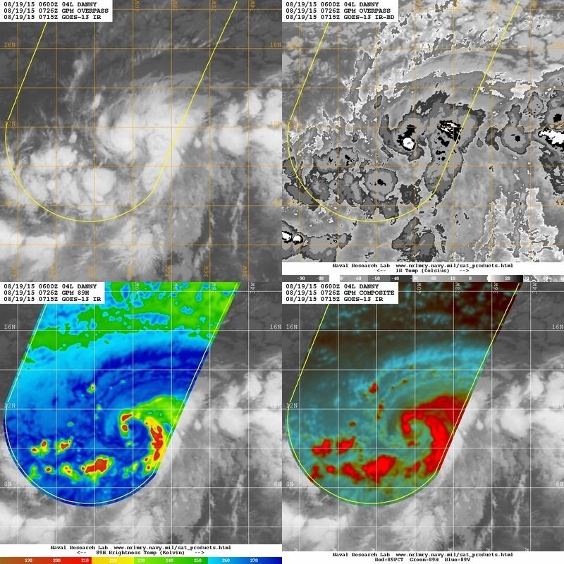
My main point was that there was dry air inhibiting intensification as well as a bit of shear

Microwave pass confirms the dry air, much of the southern quadrant is devoid of convection.
http://199.9.2.143/tcdat/tc15/ATL/04L.DANNY/gmi/color/2degreeticks/20150819.0726.gpm.x.colorpct_89h_89v.04LDANNY.45kts-1000mb-113N-396W.46pc.jpg
0 likes   
The above post is not official and should not be used as such. It is the opinion of the poster and may or may not be backed by sound meteorological data. It is not endorsed by any professional institution or storm2k.org. For official information, please refer to the NHC and NWS products.

ozonepete
Professional-Met
Professional-Met
Posts: 4743
Joined: Mon Sep 07, 2009 3:23 pm
Location: From Ozone Park, NYC / Now in Brooklyn, NY

Re: ATL: DANNY - Tropical Storm - Discussion

#392 Postby ozonepete » Wed Aug 19, 2015 3:06 am

spiral wrote:
ozonepete wrote:You really can't make such big forecast changes over a 1 or 2 hour time period because of the way the satellite image changed. In most cases you just have to let this play out for at least 12 hours at a time before you can make meaningful forecast changes. Nothing of importance can usually be discerned over a shorter time period.


Was not implying this will dry up in the short term was more or less just saying any live llcc traversing the tropics is threat.


I know, spiral. I wasn't really talking about you. Your comments made sense. :)
0 likes   

User avatar
Nimbus
Category 5
Category 5
Posts: 5300
Joined: Mon Jul 19, 2004 10:54 am

Re: ATL: DANNY - Tropical Storm - Discussion

#393 Postby Nimbus » Wed Aug 19, 2015 3:56 am

Looks like some dry air intrusion on the infrared but the small core is still moist and intact.
Glad to see the weakness back in the latest model run.
Last few hours the track looks almost due west. but there may not have been much intensification overnight.
PR would probably like to see Danny gain a little latitude so they get the weaker south side winds with their rain.
0 likes   

User avatar
NDG
S2K Supporter
S2K Supporter
Posts: 15446
Joined: Sun Jul 09, 2006 10:14 pm
Location: Orlando, FL

Re: ATL: DANNY - Tropical Storm - Discussion

#394 Postby NDG » Wed Aug 19, 2015 4:20 am

Looks like some dry air is already starting to affect Danny this morning, should be able to mix it out later today. So IMO no hurricane today, more likely tomorrow.

Image
0 likes   

User avatar
Gustywind
Category 5
Category 5
Posts: 12334
Joined: Mon Sep 03, 2007 7:29 am
Location: Baie-Mahault, GUADELOUPE

#395 Postby Gustywind » Wed Aug 19, 2015 5:01 am

000
WTNT34 KNHC 190843
TCPAT4

BULLETIN
TROPICAL STORM DANNY ADVISORY NUMBER 4
NWS NATIONAL HURRICANE CENTER MIAMI FL AL042015
500 AM AST WED AUG 19 2015

...DANNY FORECAST TO STRENGTHEN OVER THE TROPICAL ATLANTIC...


SUMMARY OF 500 AM AST...0900 UTC...INFORMATION
----------------------------------------------
LOCATION...11.3N 40.2W
ABOUT 1445 MI...2325 KM E OF THE LESSER ANTILLES
MAXIMUM SUSTAINED WINDS...50 MPH...85 KM/H
PRESENT MOVEMENT...W OR 280 DEGREES AT 14 MPH...22 KM/H
MINIMUM CENTRAL PRESSURE...1000 MB...29.53 INCHES


WATCHES AND WARNINGS
--------------------
There are no coastal watches or warnings in effect.


DISCUSSION AND 48-HOUR OUTLOOK
------------------------------
At 500 AM AST (0900 UTC), the center of Tropical Storm Danny was
located near latitude 11.3 North, longitude 40.2 West. Danny is
moving toward the west near 14 mph (22 km/h), and a track to
the west-northwest is expected during the next 48 hours.

Maximum sustained winds remain near 50 mph (85 km/h) with higher
gusts. Some strengthening is forecast during the next 48 hours, and
Danny could become a hurricane on Thursday.

Tropical storm force winds extend outward up to 45 miles (75 km)
from the center.

The estimated minimum central pressure is 1000 mb (29.53 inches).


HAZARDS AFFECTING LAND
----------------------
None.


NEXT ADVISORY
-------------
Next complete advisory at 1100 AM AST.

$$
Forecaster Avila
0 likes   

User avatar
Gustywind
Category 5
Category 5
Posts: 12334
Joined: Mon Sep 03, 2007 7:29 am
Location: Baie-Mahault, GUADELOUPE

#396 Postby Gustywind » Wed Aug 19, 2015 5:15 am

DATE/TIME LAT LON CLASSIFICATION STORM
19/0545 UTC 11.3N 39.2W T2.5/2.5 DANNY
18/2345 UTC 11.0N 38.3W T2.5/2.5 DANNY
18/1745 UTC 11.1N 37.0W T2.0/2.0 04L
18/1145 UTC 10.2N 35.9W T2.0/2.0 96L
18/0545 UTC 9.5N 34.4W T1.5/1.5 96L
18/0000 UTC 9.3N 33.2W T1.0/1.0 96L
17/1745 UTC 9.8N 32.8W T1.0/1.0 96L
17/1145 UTC 9.6N 31.0W T1.0/1.0 96L
17/0545 UTC 9.8N 29.9W T1.0/1.0 96L
0 likes   

User avatar
Gustywind
Category 5
Category 5
Posts: 12334
Joined: Mon Sep 03, 2007 7:29 am
Location: Baie-Mahault, GUADELOUPE

#397 Postby Gustywind » Wed Aug 19, 2015 5:47 am


TROPICAL WEATHER DISCUSSION
NWS NATIONAL HURRICANE CENTER MIAMI FL
805 AM EDT WED AUG 19 2015

...SPECIAL FEATURES...

TROPICAL STORM DANNY IS LOCATED NEAR 11.3N 40.2W AT 0900
UTC...MOVING WEST AT 12 KT. ESTIMATED MINIMUM CENTRAL PRESSURE
IS 1000 MB. MAXIMUM SUSTAINED WIND SPEED IS 45 KT WITH GUSTS TO
55 KT. CLUSTERS OF SCATTERED MODERATE CONVECTION ARE FROM 05N TO
13N BETWEEN 36W AND 42W. SOME ADDITIONAL STRENGTHENING IS
FORECAST DURING THE NEXT 48 HOURS AND DANNY COULD BECOME A
HURRICANE ON THURSDAY. PLEASE SEE LATEST NHC FORECAST/ADVISORY
UNDER AWIPS/WMO HEADERS TCMAT4/WTNT24 KNHC FOR MORE DETAILS.
0 likes   

leanne_uk
Tropical Storm
Tropical Storm
Posts: 214
Age: 42
Joined: Fri Sep 04, 2009 4:38 pm
Location: Loughborough countryside, Leicestershire, UK

Re: ATL: DANNY - Tropical Storm - Discussion

#398 Postby leanne_uk » Wed Aug 19, 2015 5:51 am

Am I right in thinking now that Danny has gone above 11 degrees N.... Grenada will be spared a hit?

My mother in law is here in the UK for a couple of months and I need to get hold of the family there to sort out protecting the house on the Island if needs be.

Thanks
0 likes   

USTropics
Professional-Met
Professional-Met
Posts: 2651
Joined: Sun Aug 12, 2007 3:45 am
Location: Florida State University

Re: ATL: DANNY - Tropical Storm - Discussion

#399 Postby USTropics » Wed Aug 19, 2015 5:52 am

First visible images of the day. Copious amounts of moisture to work with for sure:

Image

Close up 1km Vis zoom from CIMSS. I've marked the latest center coordinates provided by the NHC:

Image
0 likes   

User avatar
northjaxpro
S2K Supporter
S2K Supporter
Posts: 8900
Joined: Mon Sep 27, 2010 11:21 am
Location: Jacksonville, FL

Re: ATL: DANNY - Tropical Storm - Discussion

#400 Postby northjaxpro » Wed Aug 19, 2015 6:03 am

NDG wrote:Looks like some dry air is already starting to affect Danny this morning, should be able to mix it out later today. So IMO no hurricane today, more likely tomorrow.

Image


Yeah, Danny overnight did wrap some dry air into its circulation, which for now stopped it from intensifying any farther or else it would have become a hurricane today. Danny is still in a very favorable and moist environment overall and should strengthen into a hurricane within the next 24 hours.
0 likes   
NEVER, EVER SAY NEVER in the tropics and weather in general, and most importantly, with life itself!!

________________________________________________________________________________________

Fay 2008 Beryl 2012 Debby 2012 Colin 2016 Hermine 2016 Julia 2016 Matthew 2016 Irma 2017 Dorian 2019


Return to “2015”

Who is online

Users browsing this forum: No registered users and 3 guests