Weak low in NE Gulf of Mexico: (Is Invest 95L)
Moderator: S2k Moderators
Forum rules

The posts in this forum are NOT official forecasts and should not be used as such. They are just the opinion of the poster and may or may not be backed by sound meteorological data. They are NOT endorsed by any professional institution or STORM2K. For official information, please refer to products from the National Hurricane Center and National Weather Service.
-
hurricanedude

- Military Member

- Posts: 1856
- Joined: Tue Oct 08, 2002 9:54 am
- Location: Virginia Beach, Virginia
- Contact:

-
hurricanedude
- Military Member
- Posts: 1856
- Joined: Tue Oct 08, 2002 9:54 am
- Location: Virginia Beach, Virginia
- Contact:
Re: Weak low in NE Gulf of Mexico
Cant they issue a Special Outlook instead of waiting until 8
0 likes
-
northjaxpro

- S2K Supporter

- Posts: 8900
- Joined: Mon Sep 27, 2010 11:21 am
- Location: Jacksonville, FL
0 likes
NEVER, EVER SAY NEVER in the tropics and weather in general, and most importantly, with life itself!!
________________________________________________________________________________________
Fay 2008 Beryl 2012 Debby 2012 Colin 2016 Hermine 2016 Julia 2016 Matthew 2016 Irma 2017 Dorian 2019
________________________________________________________________________________________
Fay 2008 Beryl 2012 Debby 2012 Colin 2016 Hermine 2016 Julia 2016 Matthew 2016 Irma 2017 Dorian 2019
Re: Weak low in NE Gulf of Mexico
Holy cow lpoking at the web cams, One of my fave beaches. Madeira beach is about wiped out.
0 likes
The beach @ honeymoon is submerged/washed away. One of the boardwalks to the beach just drops off about 3 feet. There is some serious sand lurching around on our coast. It is impressive. I'm back home now but still covered in salt. This gradient wind escalated quickly today and without warning but it makes perfect sense since our low has become an overachiever.
0 likes
-
northjaxpro
- S2K Supporter
- Posts: 8900
- Joined: Mon Sep 27, 2010 11:21 am
- Location: Jacksonville, FL
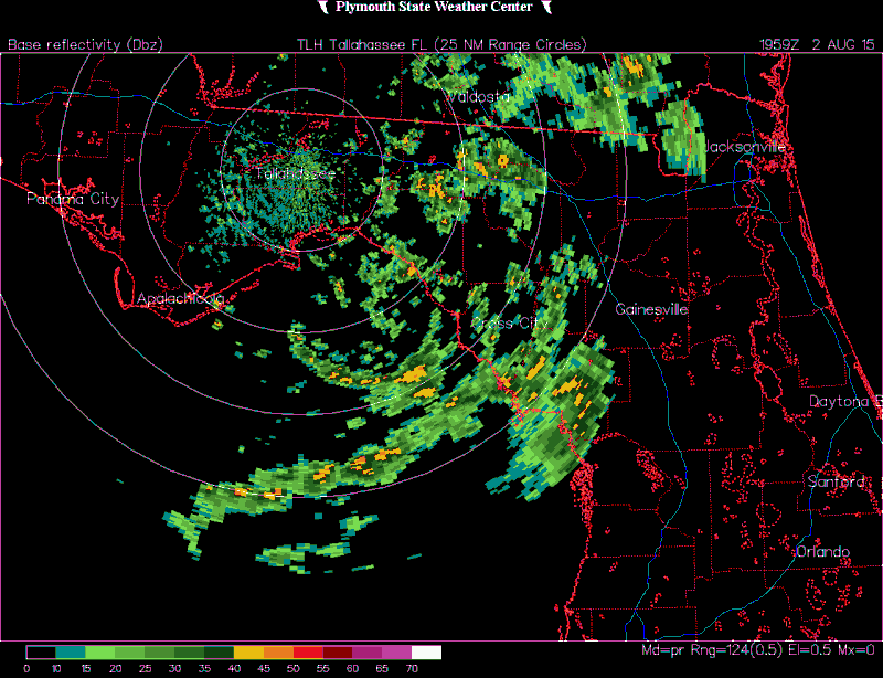
Another thing to point out how the Low is getting its act together is that it is beginning to get moist on the outer periphery of the system. Earlier today, there was no convection to the west and northwest of the circulation. Looking at the radar currently, you can see a band spiraling down out of SW GA south to the west of Tallahassee southward to the coast feeding into the circulation.
0 likes
NEVER, EVER SAY NEVER in the tropics and weather in general, and most importantly, with life itself!!
________________________________________________________________________________________
Fay 2008 Beryl 2012 Debby 2012 Colin 2016 Hermine 2016 Julia 2016 Matthew 2016 Irma 2017 Dorian 2019
________________________________________________________________________________________
Fay 2008 Beryl 2012 Debby 2012 Colin 2016 Hermine 2016 Julia 2016 Matthew 2016 Irma 2017 Dorian 2019
Thank the Lord this a test run. Any storm moving from a westerly direction is bad for us. If and when ever get another high end storm.. you can see from just this that a low end hurricane would decimate this are moving that direction. By the way.look at the flooding from the tarpon springs web cam.
0 likes
-
northjaxpro
- S2K Supporter
- Posts: 8900
- Joined: Mon Sep 27, 2010 11:21 am
- Location: Jacksonville, FL
If you look at JAX and Tallahassee radar composites, check out the rather impressive convective band on the southern side of the circulation center. The most impressive band seen to this point. This system just keeps on looking better and better. Also, the last couple of frames on radar loop showed more of a due south drift in my estimation.
0 likes
NEVER, EVER SAY NEVER in the tropics and weather in general, and most importantly, with life itself!!
________________________________________________________________________________________
Fay 2008 Beryl 2012 Debby 2012 Colin 2016 Hermine 2016 Julia 2016 Matthew 2016 Irma 2017 Dorian 2019
________________________________________________________________________________________
Fay 2008 Beryl 2012 Debby 2012 Colin 2016 Hermine 2016 Julia 2016 Matthew 2016 Irma 2017 Dorian 2019
Re:
psyclone wrote:The beach @ honeymoon is submerged/washed away. One of the boardwalks to the beach just drops off about 3 feet. There is some serious sand lurching around on our coast. It is impressive. I'm back home now but still covered in salt. This gradient wind escalated quickly today and without warning but it makes perfect sense since our low has become an overachiever.
I hope no boaters got caught offguard this afternoon.
0 likes
-
tropicwatch

- Category 5

- Posts: 3427
- Age: 62
- Joined: Sat Jun 02, 2007 10:01 am
- Location: The Villages, Florida
- Contact:
Re:
caneman wrote:Thank the Lord this a test run. Any storm moving from a westerly direction is bad for us. If and when ever get another high end storm.. you can see from just this that a low end hurricane would decimate this are moving that direction. By the way.look at the flooding from the tarpon springs web cam.
Do you have the link?
0 likes
Tropicwatch
Agnes 72', Eloise 75, Elena 85', Kate 85', Charley 86', Florence 88', Beryl 94', Dean 95', Erin 95', Opal 95', Earl 98', Georges 98', Ivan 2004', Arlene 2005', Dennis 2005', Ida 2009' Debby 2012' Irma 2017' Michael 2018'
Agnes 72', Eloise 75, Elena 85', Kate 85', Charley 86', Florence 88', Beryl 94', Dean 95', Erin 95', Opal 95', Earl 98', Georges 98', Ivan 2004', Arlene 2005', Dennis 2005', Ida 2009' Debby 2012' Irma 2017' Michael 2018'
Re:
NCSTORMMAN wrote:Should not be moving south much longer though correct?
Yeah, the models keep insisting that the low will eventually move NE, the longer it stays over the water the higher the chances it will continue to organize.
0 likes
-
NCSTORMMAN
Re: Re:
NDG wrote:NCSTORMMAN wrote:Should not be moving south much longer though correct?
Yeah, the models keep insisting that the low will eventually move NE, the longer it stays over the water the higher the chances it will continue to organize.
My thing is what is going to move it Northeast? Steering winds are weak and most of the maps show southward movement as far as I can tell (unprofessional computer programmer thinking) lol. I am no weatherman but not seeing what picks it up.
0 likes
Re: Re:
NDG wrote:psyclone wrote:The beach @ honeymoon is submerged/washed away. One of the boardwalks to the beach just drops off about 3 feet. There is some serious sand lurching around on our coast. It is impressive. I'm back home now but still covered in salt. This gradient wind escalated quickly today and without warning but it makes perfect sense since our low has become an overachiever.
I hope no boaters got caught offguard this afternoon.
For sure. We didn't even have a small craft advisory south of Tarpon until recently. It is perilous out there.
0 likes
Who is online
Users browsing this forum: No registered users and 133 guests