This is the Complex of Convection that has my attention, it has been there since last night and continues to refire. Check this radar and a satellite loop and you'll see what I mean.
http://radar.weather.gov/ridge/radar.php?product=N0Z&rid=evx&loop=yes
Weak low in NE Gulf of Mexico: (Is Invest 95L)
Moderator: S2k Moderators
Forum rules

The posts in this forum are NOT official forecasts and should not be used as such. They are just the opinion of the poster and may or may not be backed by sound meteorological data. They are NOT endorsed by any professional institution or STORM2K. For official information, please refer to products from the National Hurricane Center and National Weather Service.
-
Dean4Storms
- S2K Supporter

- Posts: 6358
- Age: 63
- Joined: Sun Aug 31, 2003 1:01 pm
- Location: Miramar Bch. FL
-
Dean4Storms
- S2K Supporter
- Posts: 6358
- Age: 63
- Joined: Sun Aug 31, 2003 1:01 pm
- Location: Miramar Bch. FL
Re: Weak low in NE Gulf of Mexico
Now compare that convective mass to this satellite loop, looking due South of Destin and due West of Tampa, right where they intersect....
http://www.nrlmry.navy.mil/nexsat-bin/nexsat.cgi?BASIN=CONUS&SUB_BASIN=focus_regions&AGE=Latest&CCA=NorthAmerica-CONUS-East&SSC=GulfOfMexico-x-x&PRODUCT=vis_ir_background&SUB_PRODUCT=goes&PAGETYPE=static&SIZE=Thumb&PATH=NorthAmerica-CONUS-East/GulfOfMexico-x-x/vis_ir_background/goes&&buttonPressed=Animate&ANIM_TYPE=Instant
http://www.nrlmry.navy.mil/nexsat-bin/nexsat.cgi?BASIN=CONUS&SUB_BASIN=focus_regions&AGE=Latest&CCA=NorthAmerica-CONUS-East&SSC=GulfOfMexico-x-x&PRODUCT=vis_ir_background&SUB_PRODUCT=goes&PAGETYPE=static&SIZE=Thumb&PATH=NorthAmerica-CONUS-East/GulfOfMexico-x-x/vis_ir_background/goes&&buttonPressed=Animate&ANIM_TYPE=Instant
0 likes
-
NCSTORMMAN
If you look west of Tampa at the IR images at the link below you can clearly see a strong twist in that heavy convection.
http://wwwghcc.msfc.nasa.gov/cgi-bin/ge ... color=gray
http://wwwghcc.msfc.nasa.gov/cgi-bin/ge ... color=gray
0 likes


Re: Weak low in NE Gulf of Mexico
The surface low that is devoid of convection appears to be reforming further southwest which will leave a very elongated circulation. Could be a real flood problem for west coast of Florida.
These elongated messes often don't wind up into strong symmetrical storms but they sure produce a lot of rain!
These elongated messes often don't wind up into strong symmetrical storms but they sure produce a lot of rain!
0 likes

Re:
NCSTORMMAN wrote:The huge convection west of Tampa has a spin to it and it appears to be heading south. I do not think that is an eddy. Can someone explain what that is. The spin is going south.
To me is just nothing but a mid level vorticity/energy that got sheared away from the surface low yesterday evening.
0 likes
-
NCSTORMMAN
Re: Re:
NDG wrote:NCSTORMMAN wrote:The huge convection west of Tampa has a spin to it and it appears to be heading south. I do not think that is an eddy. Can someone explain what that is. The spin is going south.
To me is just nothing but a mid level vorticity/energy that got sheared away from the surface low yesterday evening.
Thing is someone mentioned a new low has formed there or right around there right? My biggest thing that keeps me coming back to this area is that convection has stayed constant in that same area and winds and waves are highest right around there.
0 likes
Re: Re:
NCSTORMMAN wrote:NDG wrote:NCSTORMMAN wrote:The huge convection west of Tampa has a spin to it and it appears to be heading south. I do not think that is an eddy. Can someone explain what that is. The spin is going south.
To me is just nothing but a mid level vorticity/energy that got sheared away from the surface low yesterday evening.
Thing is someone mentioned a new low has formed there or right around there right? My biggest thing that keeps me coming back to this area is that convection has stayed constant in that same area and winds and waves are highest right around there.
Yeah, if the surface low at Apalachee Bay was to weaken or dissipate this would be the are to watch as a new surface low would take over, but I still do not see that, there is nothing but westerly winds underneath all that convection, nothing indicating to me that a surface low has formed at least yet.
0 likes
For those with high speed internet below is a 12 hour radar loop from Tallahassee, the surface low has not moved much during the day, if anything a slow SSE drift during the past 6-8 hrs or so.
I remember looking at models last night which were showing it that it would had been approaching Lake City by now.
Speed up the loop.
http://weather.rap.ucar.edu/radar/displ ... uration=12
I remember looking at models last night which were showing it that it would had been approaching Lake City by now.
Speed up the loop.
http://weather.rap.ucar.edu/radar/displ ... uration=12
0 likes

Re: Weak low in NE Gulf of Mexico
The spin seen on the IR loops is from a collapsing thunderstorm complex but as mentioned before the continued refiring of this general area will keep me watching as the LLC seems to be weakening.
Nice loop NDG
Nice loop NDG
Last edited by tailgater on Sun Aug 02, 2015 2:32 pm, edited 1 time in total.
0 likes
The following post is NOT an official forecast and should not be used as such. It is just the opinion of the poster and may or may not be backed by sound meteorological data. It is NOT endorsed by any professional institution including storm2k.org For Official Information please refer to the NHC and NWS products.
-
northjaxpro

- S2K Supporter
- Posts: 8900
- Joined: Mon Sep 27, 2010 11:21 am
- Location: Jacksonville, FL
Actually, the surface Low pressure has been drifting south/southeast since late yesterday afternnon NDG. NWS Tallahassee forecast office and surface observations at 21Z yesterday had the surface Low very near the Tallahassee area. As a matter of fact the Tallahassee mets stated that in their late afternoon AFD yesterday. Since that time late yesterday afternoon to current time, if you track the movement of the Low, it has been drifting in a south/southeast motion to back over Apalachee Bay and it has remained just offshore as you pointed out all during today to this point.
I am surprised by the delay in the motion forecast to go to the northeast. But, NHC and the models still insist for that northeast motion to resume sometime this evening.
I am surprised by the delay in the motion forecast to go to the northeast. But, NHC and the models still insist for that northeast motion to resume sometime this evening.
0 likes
NEVER, EVER SAY NEVER in the tropics and weather in general, and most importantly, with life itself!!
________________________________________________________________________________________
Fay 2008 Beryl 2012 Debby 2012 Colin 2016 Hermine 2016 Julia 2016 Matthew 2016 Irma 2017 Dorian 2019
________________________________________________________________________________________
Fay 2008 Beryl 2012 Debby 2012 Colin 2016 Hermine 2016 Julia 2016 Matthew 2016 Irma 2017 Dorian 2019
-
Dean4Storms
- S2K Supporter
- Posts: 6358
- Age: 63
- Joined: Sun Aug 31, 2003 1:01 pm
- Location: Miramar Bch. FL
Again, if you zoom into this convection due south of Destin and due west of Tampa you'll see it rotating and convection remaining. I know it only seeing at mid levels but I believe this is far enough SW from the Low near the Big Bend of FL that if this convection continues you could get a surface Low going if there isn't one there already! Appears to me to be a very slow drift southward.
http://radar.weather.gov/ridge/radar.ph ... x&loop=yes
http://radar.weather.gov/ridge/radar.ph ... x&loop=yes
0 likes
-
NCSTORMMAN
Re:
Dean4Storms wrote:Again, if you zoom into this convection due south of Destin and due west of Tampa you'll see it rotating and convection remaining. I know it only seeing at mid levels but I believe this is far enough SW from the Low near the Big Bend of FL that if this convection continues you could get a surface Low going if there isn't one there already! Appears to me to be a very slow drift southward.
http://radar.weather.gov/ridge/radar.ph ... x&loop=yes
I agree and the NWS has already said there is a surface low near there or right there.
0 likes
-
northjaxpro
- S2K Supporter
- Posts: 8900
- Joined: Mon Sep 27, 2010 11:21 am
- Location: Jacksonville, FL
Dean, I have taken a very close look at what you are referring to and the area I think you are looking at is approximately at 27.0 N 87.2 W. I did count 3 different pulsations or re-firings of convection in that general coordinate spot during that entire loop. Now, it is interesting to see that occurring in the same general area, and whether or not it means a new surface reflection is attempting to organize remains to be seen. The surface Low in Apalachee Bay would have to become diffuse in the near term for a true relocation of a surface low to occur.
I have studied the loop you pointed out Dean and that area. I can see I think the area you keep referencing. You are not just seeing imaginary things as far as I am concerned lol..
I have studied the loop you pointed out Dean and that area. I can see I think the area you keep referencing. You are not just seeing imaginary things as far as I am concerned lol..
Last edited by northjaxpro on Sun Aug 02, 2015 2:46 pm, edited 2 times in total.
0 likes
NEVER, EVER SAY NEVER in the tropics and weather in general, and most importantly, with life itself!!
________________________________________________________________________________________
Fay 2008 Beryl 2012 Debby 2012 Colin 2016 Hermine 2016 Julia 2016 Matthew 2016 Irma 2017 Dorian 2019
________________________________________________________________________________________
Fay 2008 Beryl 2012 Debby 2012 Colin 2016 Hermine 2016 Julia 2016 Matthew 2016 Irma 2017 Dorian 2019
-
HurricaneBelle

- S2K Supporter
- Posts: 1209
- Joined: Sun Aug 27, 2006 6:12 pm
- Location: Clearwater, FL
Re: Weak low in NE Gulf of Mexico
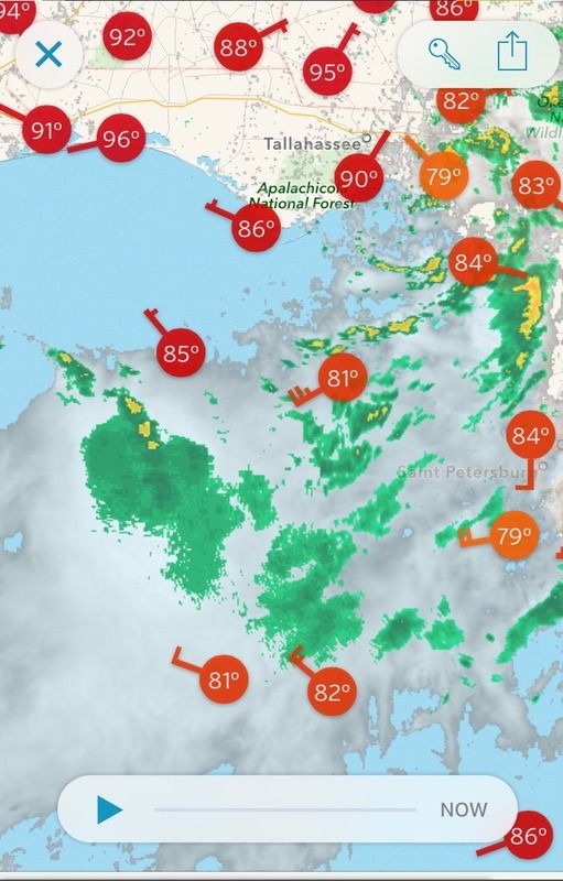
Something is going on driving the winds gusting in the high 20s and 30s along the coast in West Central Florida, and it's not convection as most of that has moved well to the east. Here are some 3PM obs:
Code: Select all
BROOKSVILLE    LGT RAIN  79  73  82 SW15G36   29.94S
CLEARWATER     CLOUDY    82  70  66 SW22G29   29.94F
TAMPA INTL     CLOUDY    81  71  71 SW18G28   29.95F
TAMPA EXEC     DRIZZLE   81  73  78 SW15G23   29.96F
MACDILL AFB    CLOUDY    77  76  96 SW13G23   29.95F
ST PETERSBURG  CLOUDY    81  70  69 W17G25    29.93F
SARASOTA       CLOUDY    83  71  67 SW16G24   29.96F
VENICE         FAIR      84  73  70 W22G29    29.99S
0 likes
Re: Weak low in NE Gulf of Mexico
Surface reports don't lie, there is no indication of a new surface low over the convection south of Destin. Pressures are also way higher than the main low pressure center at Apalachee Bay.

0 likes
-
NCSTORMMAN
Re: Weak low in NE Gulf of Mexico
NDG wrote:Surface reports don't lie, there is no indication of a new surface low over the convection south of Destin. Pressures are also way higher than the main low pressure center at Apalachee Bay.
BOOM! NDG drops the mic lol.
0 likes
I'm at Honeymoon island right now and can report the gulf has devoured the entire beach and is chewing through the dunes. Winds are around 25 knots and the tides are probably 1.5-2" above normal...just below the tops of the seawalls. I have not seen the gulf in this part of the world so hostile for a long time. If we ever get a real storm here we are completely screwed.
0 likes
-
northjaxpro
- S2K Supporter
- Posts: 8900
- Joined: Mon Sep 27, 2010 11:21 am
- Location: Jacksonville, FL
Another thing to point out is that the surface Low in Apalachee Bay shows no sign of dissapating or becoming diffuse. as a matter of fact, since drifting back over water today, radar and visible satellite imagery is showing rain bands picking up a bit in intensity just to the south and east of the circulation center. Fairly decent convective tops in that spiral band to the south and east of the circulation in Apalachee Bay currently.
So, there are no indications at the moment that this main Low Pressure is weakening. As a matter of fact, it is looking the best it has all day since moving back over water drifting south-southeast.
So, there are no indications at the moment that this main Low Pressure is weakening. As a matter of fact, it is looking the best it has all day since moving back over water drifting south-southeast.
Last edited by northjaxpro on Sun Aug 02, 2015 3:08 pm, edited 3 times in total.
0 likes
NEVER, EVER SAY NEVER in the tropics and weather in general, and most importantly, with life itself!!
________________________________________________________________________________________
Fay 2008 Beryl 2012 Debby 2012 Colin 2016 Hermine 2016 Julia 2016 Matthew 2016 Irma 2017 Dorian 2019
________________________________________________________________________________________
Fay 2008 Beryl 2012 Debby 2012 Colin 2016 Hermine 2016 Julia 2016 Matthew 2016 Irma 2017 Dorian 2019
-
HurricaneBelle
- S2K Supporter
- Posts: 1209
- Joined: Sun Aug 27, 2006 6:12 pm
- Location: Clearwater, FL
It's the low over Apalachee Bay that's driving the winds in the Tampa Bay area according to the just-released TBW AFD:
http://kamala.cod.edu/offs/KTBW/1508022002.fxus62.html
Today has been reminiscent of the winds we get with low-end TSs that have affected the area over the last several years like Andrea, Barry, Debby, Ernesto, Alberto, etc.
A WELL DEFINED LOW PRESSURE SYSTEM HAS DEVELOPED OVER APALACHEE
BAY THE EXTREME NORTHEAST PORTION OF THE GULF. THE PRESSURE
GRADIENT BETWEEN THIS LOW AND THE ATLANTIC RIDGE TO THE SOUTHEAST
HAS TIGHTENED SIGNIFICANTLY...RESULTING IN STRONGER WINDS OVER THE
REGION. IN FACT...WE HAVE ABOUT A 40 KNOT JET BETWEEN 925 AND 850
MBS THAT SHOWS UP WELL ON OUR RADAR. EVEN VERY SHALLOW SHOWER
ACTIVITY IS BRINGING DOWN 40 MPH WINDS. DEEPER SHOWERS HAVE BEEN
PRODUCING WIND GUSTS TO 45 MPH. HI-RES MODEL BLENDS DO SHOW THIS
FEATURE WEAKENING OVERNIGHT...BUT THIS IS NOT A GUARANTEE.
http://kamala.cod.edu/offs/KTBW/1508022002.fxus62.html
Today has been reminiscent of the winds we get with low-end TSs that have affected the area over the last several years like Andrea, Barry, Debby, Ernesto, Alberto, etc.
0 likes

Re: Weak low in NE Gulf of Mexico
On tally RAD the low pressure looks to be slowly organizing. I've got two feet above normal tides now with gusty SW winds in Hernando Beach. Neighborhood streets flooded with half a foot of standing water.
0 likes
Who is online
Users browsing this forum: bird, Google Adsense [Bot] and 137 guests