Weak low in NE Gulf of Mexico: (Is Invest 95L)

This is the general tropical discussion area. Anyone can take their shot at predicting a storms path.

Moderator: S2k Moderators

Forum rules

The posts in this forum are NOT official forecasts and should not be used as such. They are just the opinion of the poster and may or may not be backed by sound meteorological data. They are NOT endorsed by any professional institution or STORM2K. For official information, please refer to products from the National Hurricane Center and National Weather Service.

Help Support Storm2K
Message
Author
User avatar
NDG
S2K Supporter
S2K Supporter
Posts: 15446
Joined: Sun Jul 09, 2006 10:14 pm
Location: Orlando, FL

Re: Weak low in NE Gulf of Mexico

#501 Postby NDG » Sun Aug 02, 2015 11:58 am

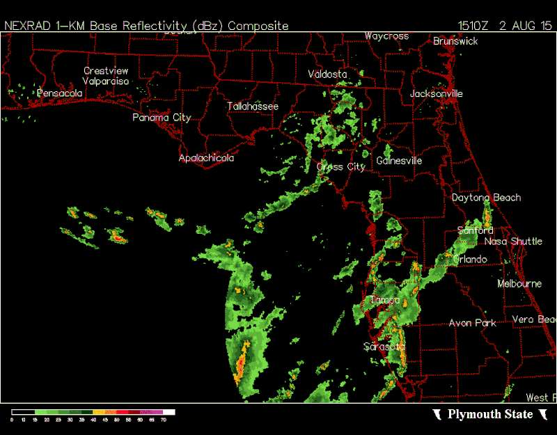
wxman57 wrote:Weak low-level swirl has moved inland into the eastern FL panhandle. Pressures are starting to rise across the NE Gulf. No evidence of any rotation in offshore obs. Development chances remain near zero.


The season is so slow that we might as well watch a naked swirl pumping a lot of moinsture into the FL Peninsula.
But I disagree with you regarding surface pressures, surface pressure reports from a couple C-MAN stations near the swirl are actually lower than what were 24 hrs ago, they are currently near 1010 mb, yesterday they were reporting near 1013mb.

http://www.ndbc.noaa.gov/station_page.php?station=ktnf1

http://weather.rap.ucar.edu/surface/ind ... s=Retrieve
0 likes   

User avatar
tailgater
S2K Supporter
S2K Supporter
Posts: 3339
Joined: Sun Jul 11, 2004 9:13 pm
Location: St. Amant La.

Re: Weak low in NE Gulf of Mexico

#502 Postby tailgater » Sun Aug 02, 2015 12:00 pm

The mass SW of that low level naked swirl has real nice convergence but it will have a hard time getting it's act together with the Big Ben swirl that close.
Image
0 likes   
The following post is NOT an official forecast and should not be used as such. It is just the opinion of the poster and may or may not be backed by sound meteorological data. It is NOT endorsed by any professional institution including storm2k.org For Official Information please refer to the NHC and NWS products.

User avatar
northjaxpro
S2K Supporter
S2K Supporter
Posts: 8900
Joined: Mon Sep 27, 2010 11:21 am
Location: Jacksonville, FL

#503 Postby northjaxpro » Sun Aug 02, 2015 12:06 pm

Image
0 likes   
NEVER, EVER SAY NEVER in the tropics and weather in general, and most importantly, with life itself!!

________________________________________________________________________________________

Fay 2008 Beryl 2012 Debby 2012 Colin 2016 Hermine 2016 Julia 2016 Matthew 2016 Irma 2017 Dorian 2019

User avatar
northjaxpro
S2K Supporter
S2K Supporter
Posts: 8900
Joined: Mon Sep 27, 2010 11:21 am
Location: Jacksonville, FL

#504 Postby northjaxpro » Sun Aug 02, 2015 12:09 pm

1009 mb in the Bend area of Apalachee Bay. As NDG pointed out, you know we have to be a little bored as weather observers tracking naked swirls LOL... But, I rather be tracking this than a full blown tropical storm or hurricane bearing down on the Florida coast as an alternative that is 100% for sure!!!!! Thank goodness for the shear.
Last edited by northjaxpro on Sun Aug 02, 2015 12:10 pm, edited 1 time in total.
0 likes   
NEVER, EVER SAY NEVER in the tropics and weather in general, and most importantly, with life itself!!

________________________________________________________________________________________

Fay 2008 Beryl 2012 Debby 2012 Colin 2016 Hermine 2016 Julia 2016 Matthew 2016 Irma 2017 Dorian 2019

User avatar
NDG
S2K Supporter
S2K Supporter
Posts: 15446
Joined: Sun Jul 09, 2006 10:14 pm
Location: Orlando, FL

#505 Postby NDG » Sun Aug 02, 2015 12:09 pm

Saved radar loop:

Image
Last edited by NDG on Sun Aug 02, 2015 12:11 pm, edited 1 time in total.
1 likes   

TheStormExpert

Re:

#506 Postby TheStormExpert » Sun Aug 02, 2015 12:11 pm

northjaxpro wrote:1009 mb in the Bend area of Apalachee Bay. As NDG pointed out, you know we have to be a little bored as weather observers tracking naked swirls LOL... But, I rather tracking this than a full blown tropical storm or hurricane that is 100% for sure!!!!!

Still wouldn't kill IMO to track a minimal TS since the effects would likely be no different.
0 likes   

User avatar
northjaxpro
S2K Supporter
S2K Supporter
Posts: 8900
Joined: Mon Sep 27, 2010 11:21 am
Location: Jacksonville, FL

#507 Postby northjaxpro » Sun Aug 02, 2015 12:15 pm

No, you are right StormExpect in terms of rainfall in that the effects with a minimal TS would be comparable to what we have already seen with the flooding down state and in the Big Bend region. However, storm surge in that area of the GOM in Apalachee Bay in even strong tropical storms can get really bad in that portion of the state. Plus, we would be dealing with a much more serious synoptical dynamic situation with a landfalling cyclone with tornadoes and wind damage inland. So for that, I am thankful to be just tracking a naked low level swirl compared to the alternative.
0 likes   
NEVER, EVER SAY NEVER in the tropics and weather in general, and most importantly, with life itself!!

________________________________________________________________________________________

Fay 2008 Beryl 2012 Debby 2012 Colin 2016 Hermine 2016 Julia 2016 Matthew 2016 Irma 2017 Dorian 2019

User avatar
NDG
S2K Supporter
S2K Supporter
Posts: 15446
Joined: Sun Jul 09, 2006 10:14 pm
Location: Orlando, FL

#508 Postby NDG » Sun Aug 02, 2015 12:19 pm

Fairly rough gulf waters on western FL beaches today with occasional wind gusts near 40 knots with some of those squalls coming in producing near 6 foot waves, fairly high for being the gulf waters.

Image
0 likes   

User avatar
HurricaneBelle
S2K Supporter
S2K Supporter
Posts: 1179
Joined: Sun Aug 27, 2006 6:12 pm
Location: Clearwater, FL

#509 Postby HurricaneBelle » Sun Aug 02, 2015 12:26 pm

NWS' WPC has identified a new low forming out of the convective mass to the W of Tampa.

DISCUSSION...CONVECTIVE COMPLEX OFFSHORE NEAR 28.4N 84.6W
(SOUTHWEST OF APALACHEE BAY) PRODUCED ENOUGH LATENT HEAT RELEASE
ALOFT FOR PRESSURE FALLS TO DEVELOP A NEW SURFACE INFLECTION.
....

WITH THE STRENGTHENING OF THE NEW SURFACE LOW...WINDS WILL BACK
TOWARD THE LOW AND GENERATE A NW-SE CONVERGENCE BAND FROM THE LOW
TOWARD THE INTERSECTION OF THE OUTER BAND DESCRIBED ABOVE...THIS
WILL ALLOW FOR INCREASED CONVECTIVE DEVELOPMENT TO INITIATE JUST
OFFSHORE FROM TAMPA NORTHWARD WITH PROLONGED REGENERATION
UPSTREAM...TO ALLOW FOR TRAINING ALONG THE COAST AND JUST INLAND
OVER THE NEXT FEW HOURS.

http://www.wpc.ncep.noaa.gov/metwatch/m ... 06&yr=2015
0 likes   

User avatar
northjaxpro
S2K Supporter
S2K Supporter
Posts: 8900
Joined: Mon Sep 27, 2010 11:21 am
Location: Jacksonville, FL

#510 Postby northjaxpro » Sun Aug 02, 2015 12:31 pm

Well, I am not surprised by another surface wave forming in that complex. Now, the bad news would be that as the system lifts out, as illustrated by WPC, a convergence band could set up bringing in more potential of torrential rainfall amounts for portions along the west coast of Florida. I would hate for that to materialize, but it is definitely a possibility for later this evening and overnight tonight.
0 likes   
NEVER, EVER SAY NEVER in the tropics and weather in general, and most importantly, with life itself!!

________________________________________________________________________________________

Fay 2008 Beryl 2012 Debby 2012 Colin 2016 Hermine 2016 Julia 2016 Matthew 2016 Irma 2017 Dorian 2019

User avatar
tailgater
S2K Supporter
S2K Supporter
Posts: 3339
Joined: Sun Jul 11, 2004 9:13 pm
Location: St. Amant La.

Re: Weak low in NE Gulf of Mexico

#511 Postby tailgater » Sun Aug 02, 2015 12:35 pm

Not a surprise here either, more bad news for the Tampa area, stay safe folks.
0 likes   
The following post is NOT an official forecast and should not be used as such. It is just the opinion of the poster and may or may not be backed by sound meteorological data. It is NOT endorsed by any professional institution including storm2k.org For Official Information please refer to the NHC and NWS products.

User avatar
Hammy
Category 5
Category 5
Posts: 5849
Age: 41
Joined: Fri May 25, 2012 5:25 pm
Contact:

#512 Postby Hammy » Sun Aug 02, 2015 12:38 pm

Is there any chance as this moves northeast that it can develop if it remains offshore after crossing Florida?
0 likes   
The above post is not official and should not be used as such. It is the opinion of the poster and may or may not be backed by sound meteorological data. It is not endorsed by any professional institution or storm2k.org. For official information, please refer to the NHC and NWS products.

User avatar
northjaxpro
S2K Supporter
S2K Supporter
Posts: 8900
Joined: Mon Sep 27, 2010 11:21 am
Location: Jacksonville, FL

#513 Postby northjaxpro » Sun Aug 02, 2015 12:43 pm

Well, NHC finally mentions the Low in Apalachee Bay in the TWO

For the North Atlantic...Caribbean Sea and the Gulf of Mexico:

A well-defined low pressure system has formed over Apalachee Bay in
the northeastern Gulf of Mexico and is producing limited shower
activity near the center. Upper-level winds are not expected to be
conducive for development while the low moves northeastward across
north Florida and near the southeastern United States coast during
the next few days.
* Formation chance through 48 hours...low...10 percent
* Formation chance through 5 days...low...10 percent
0 likes   
NEVER, EVER SAY NEVER in the tropics and weather in general, and most importantly, with life itself!!

________________________________________________________________________________________

Fay 2008 Beryl 2012 Debby 2012 Colin 2016 Hermine 2016 Julia 2016 Matthew 2016 Irma 2017 Dorian 2019

NCSTORMMAN

#514 Postby NCSTORMMAN » Sun Aug 02, 2015 1:14 pm

I am confused is there two lows? Or just the one below Apalachee bay? The coordinates that HurricaneBelle gave about a new surface area are further south of the low that the NHC is looking at.
0 likes   

User avatar
NDG
S2K Supporter
S2K Supporter
Posts: 15446
Joined: Sun Jul 09, 2006 10:14 pm
Location: Orlando, FL

#515 Postby NDG » Sun Aug 02, 2015 1:31 pm

:uarrow: The main surface low pressure is the one at Apalachee Bay, the vorticity west of Tampa is thought to have formed another surface low pressure area, but I see really no evidence of it, at least yet.
0 likes   

NCSTORMMAN

Re:

#516 Postby NCSTORMMAN » Sun Aug 02, 2015 1:32 pm

NDG wrote::uarrow: The main surface low pressure is the one at Apalachee Bay, the vorticity west of Tampa is thought to have formed another surface low pressure area, but I see really no evidence of it, at least yet.


If there is another low there which way would it be moving and how long out at sea would it be?
0 likes   

TheStormExpert

#517 Postby TheStormExpert » Sun Aug 02, 2015 1:39 pm

Here are some still radar images of the main surface low in Apalachee Bay, it's about 7-8 miles offshore atm.

Image

Image
0 likes   

User avatar
northjaxpro
S2K Supporter
S2K Supporter
Posts: 8900
Joined: Mon Sep 27, 2010 11:21 am
Location: Jacksonville, FL

#518 Postby northjaxpro » Sun Aug 02, 2015 1:42 pm

Just getting the first rain squall coming through my locale right now. Heavy rain and received a gust to 36 mph in this squall. This is very tropical like indeed, and with the Low still hanging back in Apalachee Bay at this time, this will be the beginning of these rain bands coming through the Jax area.

Image
Last edited by northjaxpro on Sun Aug 02, 2015 1:47 pm, edited 2 times in total.
0 likes   
NEVER, EVER SAY NEVER in the tropics and weather in general, and most importantly, with life itself!!

________________________________________________________________________________________

Fay 2008 Beryl 2012 Debby 2012 Colin 2016 Hermine 2016 Julia 2016 Matthew 2016 Irma 2017 Dorian 2019

NCSTORMMAN

#519 Postby NCSTORMMAN » Sun Aug 02, 2015 1:43 pm

The huge convection west of Tampa has a spin to it and it appears to be heading south. I do not think that is an eddy. Can someone explain what that is. The spin is going south.
0 likes   

Dean4Storms
S2K Supporter
S2K Supporter
Posts: 6358
Age: 62
Joined: Sun Aug 31, 2003 1:01 pm
Location: Miramar Bch. FL

Re:

#520 Postby Dean4Storms » Sun Aug 02, 2015 1:47 pm

HurricaneBelle wrote:NWS' WPC has identified a new low forming out of the convective mass to the W of Tampa.

DISCUSSION...CONVECTIVE COMPLEX OFFSHORE NEAR 28.4N 84.6W
(SOUTHWEST OF APALACHEE BAY) PRODUCED ENOUGH LATENT HEAT RELEASE
ALOFT FOR PRESSURE FALLS TO DEVELOP A NEW SURFACE INFLECTION.
....

WITH THE STRENGTHENING OF THE NEW SURFACE LOW...WINDS WILL BACK
TOWARD THE LOW AND GENERATE A NW-SE CONVERGENCE BAND FROM THE LOW
TOWARD THE INTERSECTION OF THE OUTER BAND DESCRIBED ABOVE...THIS
WILL ALLOW FOR INCREASED CONVECTIVE DEVELOPMENT TO INITIATE JUST
OFFSHORE FROM TAMPA NORTHWARD WITH PROLONGED REGENERATION
UPSTREAM...TO ALLOW FOR TRAINING ALONG THE COAST AND JUST INLAND
OVER THE NEXT FEW HOURS.

http://www.wpc.ncep.noaa.gov/metwatch/m ... 06&yr=2015


I thought the convection had lasted a good bit that this was a possibility and if it continues all day this might develop as long as that other Low to the NE moves on.
0 likes   


Return to “Talkin' Tropics”

Who is online

Users browsing this forum: LarryWx, Tx_Summer and 29 guests