Weak low in NE Gulf of Mexico: (Is Invest 95L)

This is the general tropical discussion area. Anyone can take their shot at predicting a storms path.

Moderator: S2k Moderators

Forum rules

The posts in this forum are NOT official forecasts and should not be used as such. They are just the opinion of the poster and may or may not be backed by sound meteorological data. They are NOT endorsed by any professional institution or STORM2K. For official information, please refer to products from the National Hurricane Center and National Weather Service.

Help Support Storm2K
Message
Author
User avatar
ronjon
Category 5
Category 5
Posts: 4822
Joined: Fri Aug 19, 2005 5:17 pm
Location: Hernando Beach, FL

Re: Weak low in NE Gulf of Mexico

#481 Postby ronjon » Sun Aug 02, 2015 8:30 am

caneman wrote:Some areas here have picked up 12 inches of rain already. They are forecasting another 3 to 6 inches. Ive.lived here 35 years and never remember anything like it. If you get a chance check some of the news sites here f for the tampa bay area to see photos. I hate El Nino for us it means copious rains and cold winters.


I'm here about 35 miles north of you along the coast in Hernando Beach. I've recorded 18.6 inches for July with another 2 inches yesterday after a rather dry June.
0 likes   

caneman
Category 5
Category 5
Posts: 1447
Joined: Fri Sep 05, 2014 5:44 am
Location: Clearwater Beach, Fl

Re: Weak low in NE Gulf of Mexico

#482 Postby caneman » Sun Aug 02, 2015 8:33 am

The real concern now is if we do get some type of tropical system in the neAR term. There will be a lot of fallen trees due to ground saturation. I guess this pattern is going to set up again next weekend. Well, the first half of summer was nice at least. I feel bad for all the vacationers that likely saved for an entire year only to have complete and entire rain outs.
0 likes   

User avatar
NDG
S2K Supporter
S2K Supporter
Posts: 15446
Joined: Sun Jul 09, 2006 10:14 pm
Location: Orlando, FL

Re: Re:

#483 Postby NDG » Sun Aug 02, 2015 8:35 am

TheStormExpert wrote:
caneman wrote:Some areas here have picked up 12 inches of rain already. They are forecasting another 3 to 6 inches. Ive.lived here 35 years and never remember anything like it. If you get a chance check some of the news sites here f for the tampa bay area to see photos. I hate El Nino for us it means copious rains and cold winters.

Typically El Niños do not have as much control over the weather here in Florida during the summer as they do during the winter.

But yeah, unfortunately expect a wetter and at least cooler than normal winter here in Florida.
:cold:


It all depends on the NAO, it is a known fact that if the NAO is positive during the winter and spring during an El Niño winter the FL Peninsula experiences near normal to above average temps with wet conditions. This happened during the 97/98 Super El Niño.
0 likes   

caneman
Category 5
Category 5
Posts: 1447
Joined: Fri Sep 05, 2014 5:44 am
Location: Clearwater Beach, Fl

Re: Weak low in NE Gulf of Mexico

#484 Postby caneman » Sun Aug 02, 2015 8:47 am

Hey Ronjon,

That sounds about right. The 12 inches was at Tampa Airport, I'm sure many cities are well above that. I was just up your way- Hernando Beach snagging some of those great Scallops.
0 likes   

TheStormExpert

Re: Weak low in NE Gulf of Mexico

#485 Postby TheStormExpert » Sun Aug 02, 2015 8:47 am

NDG wrote:I personally do not think anything will come out of that convection west of Tampa, surface trough is now way north of it, nothing but westerly winds underneath the weak mid level vorticity.
Models show surface high pressure ridge moving back in before the next trough comes down next weekend. Upper level northerly winds are forecasted to increase once again across the eastern GOM.

This pattern we're in seems too fall/winter like to allow in close development. Does anyone see this changing?
0 likes   

Dean4Storms
S2K Supporter
S2K Supporter
Posts: 6358
Age: 62
Joined: Sun Aug 31, 2003 1:01 pm
Location: Miramar Bch. FL

Re:

#486 Postby Dean4Storms » Sun Aug 02, 2015 8:53 am

TheStormExpert wrote::uarrow: Was noticing that complex earlier and thought it might be worth monitoring. Though this pesky relentless shear just won't ease up one bit!

Wonder if this will be the case here and off the SE U.S. Coast the rest of the season, or will we finally become more favorable in these regions as time goes on?


From the indications I've seen with the CFSv2 it looks like a warmer late August and Sept. for much of the Eastern Half of the USA, which would lead me to believe that Ridging is the dominating upper level pressure pattern instead of all this repetitive Troughing. If so, think we'd have less shear along the Eastern Seaboard and Gulf, might be bad timing with the Wave Train becoming more active. We'll see!
0 likes   

TheStormExpert

Re: Re:

#487 Postby TheStormExpert » Sun Aug 02, 2015 9:05 am

Dean4Storms wrote:
TheStormExpert wrote::uarrow: Was noticing that complex earlier and thought it might be worth monitoring. Though this pesky relentless shear just won't ease up one bit!

Wonder if this will be the case here and off the SE U.S. Coast the rest of the season, or will we finally become more favorable in these regions as time goes on?


From the indications I've seen with the CFSv2 it looks like a warmer late August and Sept. for much of the Eastern Half of the USA, which would lead me to believe that Ridging is the dominating upper level pressure pattern instead of all this repetitive Troughing. If so, think we'd have less shear along the Eastern Seaboard and Gulf, might be bad timing with the Wave Train becoming more active. We'll see!

Would think at some point this season we'd see a quick burst of activity which would likely be when most of our hurricanes form(similar to last season or 2006).
0 likes   

User avatar
NDG
S2K Supporter
S2K Supporter
Posts: 15446
Joined: Sun Jul 09, 2006 10:14 pm
Location: Orlando, FL

Re: Re:

#488 Postby NDG » Sun Aug 02, 2015 9:05 am

Dean4Storms wrote:
TheStormExpert wrote::uarrow: Was noticing that complex earlier and thought it might be worth monitoring. Though this pesky relentless shear just won't ease up one bit!

Wonder if this will be the case here and off the SE U.S. Coast the rest of the season, or will we finally become more favorable in these regions as time goes on?


From the indications I've seen with the CFSv2 it looks like a warmer late August and Sept. for much of the Eastern Half of the USA, which would lead me to believe that Ridging is the dominating upper level pressure pattern instead of all this repetitive Troughing. If so, think we'd have less shear along the Eastern Seaboard and Gulf, might be bad timing with the Wave Train becoming more active. We'll see!


Yes, the Euro and GFS are starting to point out to a ridging across the eastern US as we get closer to the middle of August, will it stay in place I couldn't answer that.
0 likes   

User avatar
NDG
S2K Supporter
S2K Supporter
Posts: 15446
Joined: Sun Jul 09, 2006 10:14 pm
Location: Orlando, FL

#489 Postby NDG » Sun Aug 02, 2015 9:09 am

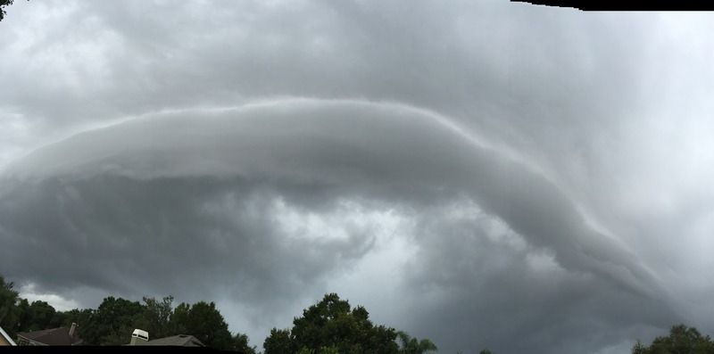
And here came the rains again, very tropical like squall.

Image
Image
0 likes   

User avatar
NDG
S2K Supporter
S2K Supporter
Posts: 15446
Joined: Sun Jul 09, 2006 10:14 pm
Location: Orlando, FL

#490 Postby NDG » Sun Aug 02, 2015 9:17 am

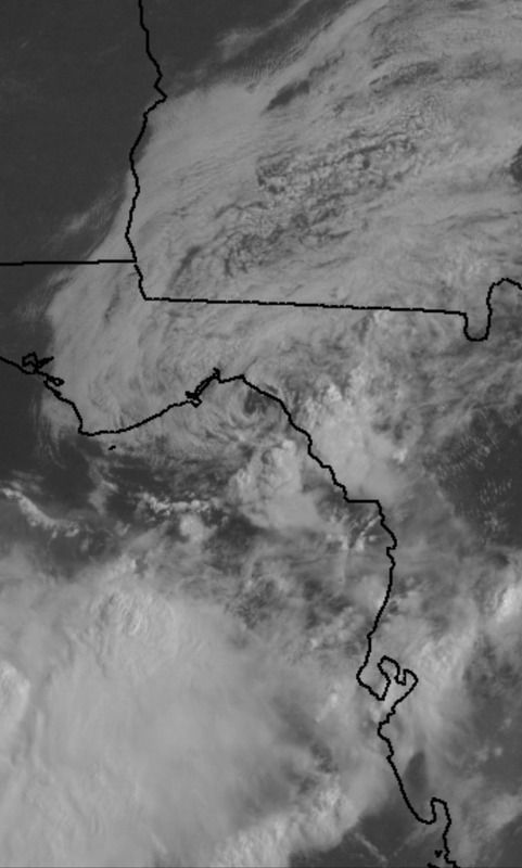
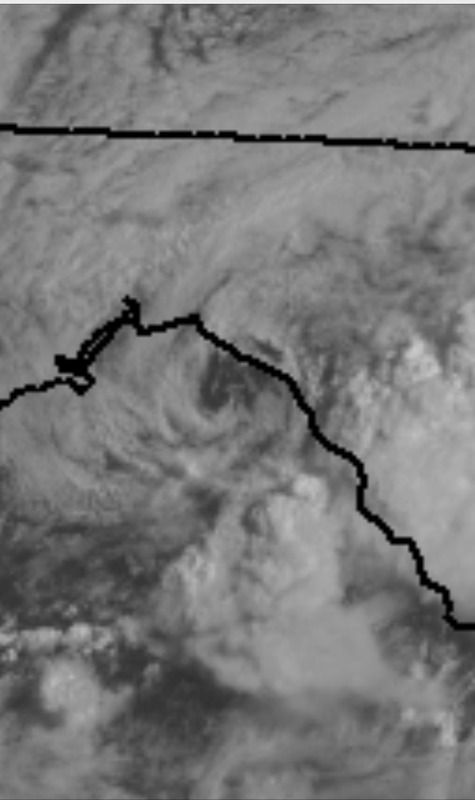
The low pressure center that could had if it wasn't for the persistent northerly shear and now drier air over it.
Looks to be nearly stationary this morning.

Image
Image
0 likes   

User avatar
northjaxpro
S2K Supporter
S2K Supporter
Posts: 8900
Joined: Mon Sep 27, 2010 11:21 am
Location: Jacksonville, FL

#491 Postby northjaxpro » Sun Aug 02, 2015 9:22 am

Yeah, that Low has been nearly stationary for the past 12 hours going back to last night NDG. It is a nice low level swirl which simply got sheared badly. We will be getting enhanced lift and moisture from that Low over North Florida later today into tonight with rain filling in towards Jax area as that Low is forecast to move northeast and up along the SE U.S. coast (hopefully) to finally get this moisture out of here, albeit only briefly as another trough is forecast to come into the region by late this upcoming week.
0 likes   
NEVER, EVER SAY NEVER in the tropics and weather in general, and most importantly, with life itself!!

________________________________________________________________________________________

Fay 2008 Beryl 2012 Debby 2012 Colin 2016 Hermine 2016 Julia 2016 Matthew 2016 Irma 2017 Dorian 2019

Dean4Storms
S2K Supporter
S2K Supporter
Posts: 6358
Age: 62
Joined: Sun Aug 31, 2003 1:01 pm
Location: Miramar Bch. FL

#492 Postby Dean4Storms » Sun Aug 02, 2015 9:31 am

Yea, that little low level swirl and low pressure look separated from the Convection further WSW down around 27.5N and 87W. That area is getting my attention this morning as the convection continues to refire over the same area. Wouldn't surprise me to see another Low form along that trough with Convection this robust if it continues today!
0 likes   

User avatar
northjaxpro
S2K Supporter
S2K Supporter
Posts: 8900
Joined: Mon Sep 27, 2010 11:21 am
Location: Jacksonville, FL

Re:

#493 Postby northjaxpro » Sun Aug 02, 2015 9:35 am

Dean4Storms wrote:Yea, that little low level swirl and low pressure look separated from the Convection further WSW down around 27.5N and 87W. That area is getting my attention this morning as the convection continues to refire over the same area. Wouldn't surprise me to see another Low form along that trough with Convection this robust if it continues today!


yeah, we have seen several of these Low Pressure waves form this past week, so I would not be surprised if another Low pressure wave developed. If one did today or tonight, it would be sheared of course, but it is worth watching in the short term.
0 likes   
NEVER, EVER SAY NEVER in the tropics and weather in general, and most importantly, with life itself!!

________________________________________________________________________________________

Fay 2008 Beryl 2012 Debby 2012 Colin 2016 Hermine 2016 Julia 2016 Matthew 2016 Irma 2017 Dorian 2019

User avatar
wxman57
Moderator-Pro Met
Moderator-Pro Met
Posts: 22979
Age: 67
Joined: Sat Jun 21, 2003 8:06 pm
Location: Houston, TX (southwest)

Re: Weak low in NE Gulf of Mexico

#494 Postby wxman57 » Sun Aug 02, 2015 9:49 am

Weak low-level swirl has moved inland into the eastern FL panhandle. Pressures are starting to rise across the NE Gulf. No evidence of any rotation in offshore obs. Development chances remain near zero.
0 likes   

User avatar
northjaxpro
S2K Supporter
S2K Supporter
Posts: 8900
Joined: Mon Sep 27, 2010 11:21 am
Location: Jacksonville, FL

Re: Weak low in NE Gulf of Mexico

#495 Postby northjaxpro » Sun Aug 02, 2015 11:08 am

wxman57 wrote:Weak low-level swirl has moved inland into the eastern FL panhandle. Pressures are starting to rise across the NE Gulf. No evidence of any rotation in offshore obs. Development chances remain near zero.


Actually, and it likely will be just a very brief time today, but actually, the low level swirl has drifted back over Apalachee Bay, seen very well on both satellite imagery and Tallahassee radar at the noon hour.
0 likes   
NEVER, EVER SAY NEVER in the tropics and weather in general, and most importantly, with life itself!!

________________________________________________________________________________________

Fay 2008 Beryl 2012 Debby 2012 Colin 2016 Hermine 2016 Julia 2016 Matthew 2016 Irma 2017 Dorian 2019

Sanibel
Category 5
Category 5
Posts: 10375
Joined: Mon Aug 30, 2004 11:06 pm
Location: Offshore SW Florida

Re: Weak low in NE Gulf of Mexico

#496 Postby Sanibel » Sun Aug 02, 2015 11:29 am

Right on time. The switch is turning on if that swirl can get over water.


You could see it starting to twist up yesterday.
0 likes   

User avatar
northjaxpro
S2K Supporter
S2K Supporter
Posts: 8900
Joined: Mon Sep 27, 2010 11:21 am
Location: Jacksonville, FL

#497 Postby northjaxpro » Sun Aug 02, 2015 11:36 am

Well, it has been meandering about and or been nearly stationary since last night. So, at the current time, it has drifted just offshore the coast in Apalachee Bay for hopefully just a brief time this afternoon before moving out to the northeast.
Last edited by northjaxpro on Sun Aug 02, 2015 11:38 am, edited 1 time in total.
0 likes   
NEVER, EVER SAY NEVER in the tropics and weather in general, and most importantly, with life itself!!

________________________________________________________________________________________

Fay 2008 Beryl 2012 Debby 2012 Colin 2016 Hermine 2016 Julia 2016 Matthew 2016 Irma 2017 Dorian 2019

User avatar
gatorcane
S2K Supporter
S2K Supporter
Posts: 23691
Age: 47
Joined: Sun Mar 13, 2005 3:54 pm
Location: Boca Raton, FL

#498 Postby gatorcane » Sun Aug 02, 2015 11:38 am

This link shows the swirl very well, look around the coastline of Apalachee Bay. Appears to be drifting south at the moment, as some have noted:

http://www.nrlmry.navy.mil/nexsat-bin/n ... PE=Instant
0 likes   

User avatar
ronjon
Category 5
Category 5
Posts: 4822
Joined: Fri Aug 19, 2005 5:17 pm
Location: Hernando Beach, FL

Re: Weak low in NE Gulf of Mexico

#499 Postby ronjon » Sun Aug 02, 2015 11:45 am

Low pressure shows up nicely on Tallahassee RAD. Just offshore drifting slowly.
0 likes   

User avatar
northjaxpro
S2K Supporter
S2K Supporter
Posts: 8900
Joined: Mon Sep 27, 2010 11:21 am
Location: Jacksonville, FL

#500 Postby northjaxpro » Sun Aug 02, 2015 11:45 am

Thanks for pulling the Navy sat link gatorcane. I always love that particular imagery. Excellent satellite imagery showing the Low level swirl emerging back over Apalachee Bay.

Also, 1009 mb surface pressure was the analysis by NHC at 15Z.
0 likes   
NEVER, EVER SAY NEVER in the tropics and weather in general, and most importantly, with life itself!!

________________________________________________________________________________________

Fay 2008 Beryl 2012 Debby 2012 Colin 2016 Hermine 2016 Julia 2016 Matthew 2016 Irma 2017 Dorian 2019


Return to “Talkin' Tropics”

Who is online

Users browsing this forum: Google Adsense [Bot], LarryWx, Tx_Summer and 37 guests