2015 EPAC Season

This is the general tropical discussion area. Anyone can take their shot at predicting a storms path.

Moderator: S2k Moderators

Forum rules

The posts in this forum are NOT official forecasts and should not be used as such. They are just the opinion of the poster and may or may not be backed by sound meteorological data. They are NOT endorsed by any professional institution or STORM2K. For official information, please refer to products from the National Hurricane Center and National Weather Service.

Help Support Storm2K
Message
Author
User avatar
Yellow Evan
Professional-Met
Professional-Met
Posts: 16143
Age: 27
Joined: Fri Jul 15, 2011 12:48 pm
Location: Henderson, Nevada/Honolulu, HI
Contact:

Re:

#461 Postby Yellow Evan » Mon Jun 29, 2015 10:04 pm

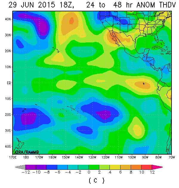
NDG wrote:Despite some Shear I think why the EPAC is also so quite lately and into the near future is because maybe some of the dry stable air from the Atlantic has been pushing past C.A. and into parts of the eastern Pacific as shown on the second image below.

http://i20.photobucket.com/albums/b245/ ... vwk6av.gif
http://i20.photobucket.com/albums/b245/ ... ytwovg.gif


I don't think the extreme shear in the Caribbean is helping either.

This is partially why El Nino years don't have much east of 120W till late season.
0 likes   

User avatar
Yellow Evan
Professional-Met
Professional-Met
Posts: 16143
Age: 27
Joined: Fri Jul 15, 2011 12:48 pm
Location: Henderson, Nevada/Honolulu, HI
Contact:

Re: Bad way to end June UGH

#462 Postby Yellow Evan » Mon Jun 29, 2015 10:08 pm

Cyclenall wrote:
Yellow Evan wrote:GFS continues to show nothing still despite an upcoming KW.

I really don't know what's causing the shear to be high, but right now, I am very disappointed.

It fits in with the rest of Earth's weather during the last 6 days, nothing but boring same old. Disappointed is an understatement, not following anything really. The "action" is really on the west side with the heat, your lucky in my view. I would have thought a quickly strengthening El Nino would have more than this!


I would kinda have though this too. My hope is that activity picks up in early July.
0 likes   

User avatar
Yellow Evan
Professional-Met
Professional-Met
Posts: 16143
Age: 27
Joined: Fri Jul 15, 2011 12:48 pm
Location: Henderson, Nevada/Honolulu, HI
Contact:

#463 Postby Yellow Evan » Tue Jun 30, 2015 2:18 am

0z GFS has a 949mbar hurricane in the medium to long range.
0 likes   

User avatar
Yellow Evan
Professional-Met
Professional-Met
Posts: 16143
Age: 27
Joined: Fri Jul 15, 2011 12:48 pm
Location: Henderson, Nevada/Honolulu, HI
Contact:

#464 Postby Yellow Evan » Tue Jun 30, 2015 1:48 pm

GFS showing a pretty potent hurricane in 2 weeks, forming around day 8-10.

GEFS hinting at stuff even closer.

EPAC is waking up at last.

Also this:

Global Tropics Hazards and Benefits Outlook Discussion
Last Updated: 06.30.15 Valid: 07.01.15 - 07.15.15
The MJO remained active during the past week, with the enhanced convective phase now over the western Pacific, as indicated by both the RMM and CPC velocity potential based MJO indices. The spatial pattern of upper level velocity potential anomalies continues to exhibit a robust and coherent Wave-1 structure. The MJO is beginning to constructively interfere with the El Nino base state, and Kelvin Wave (KW) activity over the Pacific ahead of the MJO convective envelope has resulted in strong pulses of enhanced convection.

Dynamical models, including the GEFS and ECMWF ensemble systems, indicate strong amplification of the RMM index over the western Pacific. This amplitude is primarily associated with a strong westerly wind burst near the Date Line, which may be further enhanced during Week-1 by several tropical cyclones over the western Pacific, including existing twin cyclones straddling the equator near 160E. The GFS and CFS depict little further eastward propgation of the signal, instead favoring a gradual weakening of the intraseasonal convective anomalies towards the base state. The ECMWF maintains more eastward propagation of the MJO signal, with the enhanced phase approaching the eastern Pacific by the end of Week-2. The extent of the eastward propagation of the MJO signal will play a substantial role in the potential for tropical cyclogenesis over the eastern Pacific, and even the Atlantic, during the next several weeks.

Two tropical cyclones developed on 30 June over the western Pacific near 160E: Tropical Depression 09W (Chan-hom) north of the equator, and Tropical Depression 25 south of the equator. Chan-hom is forecast to gradually intensify as it moves west-northwestward, potentially affecting Guam towards the end of the Week-1 period as a typhoon. TD 25 is forecast to modestly strengthen, but remain a tropical storm as it moves generally southward across the Solomon Islands. During Week-1, additional tropical cyclogenesis is favored across the northwestern Pacific, with a potential for a highly active pattern during the period. There is a moderate potential early in the period for two additional tropical cyclones to form between Chan-hom's current position and the Philippines during the next several days, and there is a higher potential for additional tropical cyclone formation between 155E and the Date Line. Later in the Week-1 period through Week-2, additional KW activity constructively interfering with the El Nino may promote tropical cyclone formation south or southeast of Hawaii. Additionally, relaxing vertical shear and KW activity may increase the potential for tropical cyclogenesis over southwestern portions of the East Pacific basin towards the end of Week-2.

During Week-1, dynamical models, MJO composites, and the base state all favor suppressed convection across southern portions of South Asia, parts of the Indian Ocean, and along the equator across the Maritime Continent. Suppressed convection is also favored across parts of the eastern Pacific and the adjacent Mexico and Central American coastal areas. Widespread enhanced convection is favored from the South China sea and northwestern Pacific, as well as the equatorial central and east-central Pacific. Enhanced convection is also favored across northwestern Mexico, and may impact parts of the southwestern U.S.

During Week-2, the MJO, El Nino, and any subsidence surrounding potential tropical cyclones all favor a continuation of suppressed convection across much of the Maritime Continent. Enhanced convection, associated with frontal activity and potential tropical cyclones, is forecast across much of the South China Sea, Philippines, and northwestern Pacific south of Japan. Enhanced convection associated with El Nino is anticipated to continue along and north of the equator from the Date Line eastward. Continued enhancement of the Monsoon across northwestern Mexico and the southwestern U.S. is also forecast.

Forecasts for enhanced or suppressed rainfall across Africa are provided in collaboration with CPC's Africa Desk and are based on regional scale anomaly features.
0 likes   

User avatar
cycloneye
Admin
Admin
Posts: 145389
Age: 68
Joined: Thu Oct 10, 2002 10:54 am
Location: San Juan, Puerto Rico

Re: 2015 EPAC Season

#465 Postby cycloneye » Wed Jul 01, 2015 1:13 pm

TROPICAL WEATHER OUTLOOK
NWS NATIONAL HURRICANE CENTER MIAMI FL
1100 AM PDT WED JUL 1 2015

For the eastern North Pacific...east of 140 degrees west longitude:

1. An area of low pressure is expected to form well to the east-
southeast of the Hawaiian Islands by the weekend. Upper-level
winds are forecast to become conducive for gradual development early
next week while the system moves slowly to the west or
west-northwest.
* Formation chance through 48 hours...low...near 0 percent
* Formation chance through 5 days...medium...40 percent

Forecaster Blake
0 likes   
Visit the Caribbean-Central America Weather Thread where you can find at first post web cams,radars
and observations from Caribbean basin members Click Here

User avatar
Yellow Evan
Professional-Met
Professional-Met
Posts: 16143
Age: 27
Joined: Fri Jul 15, 2011 12:48 pm
Location: Henderson, Nevada/Honolulu, HI
Contact:

#466 Postby Yellow Evan » Wed Jul 01, 2015 1:40 pm

GFS also quite bullish for days now on a major off the cast of MX second week in July.
0 likes   

User avatar
Yellow Evan
Professional-Met
Professional-Met
Posts: 16143
Age: 27
Joined: Fri Jul 15, 2011 12:48 pm
Location: Henderson, Nevada/Honolulu, HI
Contact:

Re: 2015 EPAC Season

#467 Postby Yellow Evan » Wed Jul 01, 2015 6:40 pm

Image

Image

Image

Here we go. The EPAC is back.
0 likes   

User avatar
Kingarabian
S2K Supporter
S2K Supporter
Posts: 15981
Joined: Sat Aug 08, 2009 3:06 am
Location: Honolulu, Hawaii

Re: 2015 EPAC Season

#468 Postby Kingarabian » Wed Jul 01, 2015 9:05 pm

Yellow Evan wrote:
Image

Here we go. The EPAC is back.


Looks like the first crossover of many.

Edit: Wow. Never seen a train of low pressure south of Hawaii this early in the season. Hope that STR stays put.
0 likes   
RIP Kobe Bryant

User avatar
Yellow Evan
Professional-Met
Professional-Met
Posts: 16143
Age: 27
Joined: Fri Jul 15, 2011 12:48 pm
Location: Henderson, Nevada/Honolulu, HI
Contact:

Re: 2015 EPAC Season

#469 Postby Yellow Evan » Wed Jul 01, 2015 9:20 pm

Kingarabian wrote:
Yellow Evan wrote:
http://i.imgur.com/MTL1Hu6.png?1

Here we go. The EPAC is back.


Looks like the first crossover of many.

Edit: Wow. Never seen a train of low pressure south of Hawaii this early in the season. Hope that STR stays put.


It should given it's July, but still a ways out.
0 likes   

User avatar
cycloneye
Admin
Admin
Posts: 145389
Age: 68
Joined: Thu Oct 10, 2002 10:54 am
Location: San Juan, Puerto Rico

Re: 2015 EPAC Season

#470 Postby cycloneye » Thu Jul 02, 2015 6:19 am


Todd Kimberlain @ToddKimberlain
How many epac storms can we get by next week? Hoping for something like this #tropics #hurricanes #WXGeeks #ElNino


Eric Blake ‏@EricBlake12 · 3m3 minutes ago

Eric Blake retweeted Todd Kimberlain
The record 1974 outbreak -- can we top it next week in the eastern/central Pacific? #hurricane #climate #mjo

0 likes   
Visit the Caribbean-Central America Weather Thread where you can find at first post web cams,radars
and observations from Caribbean basin members Click Here

User avatar
Ntxw
Storm2k Moderator
Storm2k Moderator
Posts: 22786
Joined: Wed Oct 21, 2009 6:34 pm
Location: DFW, Texas

#471 Postby Ntxw » Thu Jul 02, 2015 8:27 am

Still waiting for that long tracker big Hurricane signature of El Nino that racks up ACE euro kind of showing it. Any takers on a 40+ unit system? Coming soon though it seems, shear is about to die off quickly. I wouldn't be surprised if one these ends up with greater ACE units than the entire Atlantic season this year.
0 likes   
The above post and any post by Ntxw is NOT an official forecast and should not be used as such. It is just the opinion of the poster and may or may not be backed by sound meteorological data. It is NOT endorsed by any professional institution including Storm2k. For official information, please refer to NWS products.

  Help support Storm2K!
Help Support Storm2K

User avatar
Yellow Evan
Professional-Met
Professional-Met
Posts: 16143
Age: 27
Joined: Fri Jul 15, 2011 12:48 pm
Location: Henderson, Nevada/Honolulu, HI
Contact:

Re: 2015 EPAC Season

#472 Postby Yellow Evan » Thu Jul 02, 2015 9:09 am

Image

6z GFS

Image

0z ECMWF

Image
0 likes   

User avatar
Yellow Evan
Professional-Met
Professional-Met
Posts: 16143
Age: 27
Joined: Fri Jul 15, 2011 12:48 pm
Location: Henderson, Nevada/Honolulu, HI
Contact:

#473 Postby Yellow Evan » Thu Jul 02, 2015 9:10 am

An area of disturbed weather has formed about 1700 miles
east-southeast of the Hawaiian Islands. Environmental conditions
are forecast to become conducive for gradual development of this
system over the next several days while it moves slowly
west-northwestward.
* Formation chance through 48 hours...low...near 20 percent
* Formation chance through 5 days...medium...50 percent
0 likes   

User avatar
cycloneye
Admin
Admin
Posts: 145389
Age: 68
Joined: Thu Oct 10, 2002 10:54 am
Location: San Juan, Puerto Rico

Re: 2015 EPAC Season

#474 Postby cycloneye » Thu Jul 02, 2015 12:52 pm

TROPICAL WEATHER OUTLOOK
NWS NATIONAL HURRICANE CENTER MIAMI FL
1100 AM PDT THU JUL 2 2015

For the eastern North Pacific...east of 140 degrees west longitude:

1. A large area of disturbed weather is located over the far
southwestern eastern Pacific centered about 1500 miles
east-southeast of the Hawaiian Islands. Environmental conditions
are forecast to become conducive for gradual development of this
system over the next several days while it moves slowly
west-northwestward.
* Formation chance through 48 hours...low...30 percent
* Formation chance through 5 days...medium...60 percent

2. A tropical wave located several hundred miles southwest of
Manzanillo Mexico is producing disorganized showers and
thunderstorms. Upper-level conditions are forecast to become
conducive for some development of this system early next week while
it moves to the west-northwest at 10 to 15 mph.
* Formation chance through 48 hours...low...near 0 percent
* Formation chance through 5 days...low...30 percent

Forecaster Blake


Image
0 likes   
Visit the Caribbean-Central America Weather Thread where you can find at first post web cams,radars
and observations from Caribbean basin members Click Here

User avatar
Yellow Evan
Professional-Met
Professional-Met
Posts: 16143
Age: 27
Joined: Fri Jul 15, 2011 12:48 pm
Location: Henderson, Nevada/Honolulu, HI
Contact:

#475 Postby Yellow Evan » Thu Jul 02, 2015 1:22 pm

The 30/60 is now 95E.
0 likes   

CrazyC83
Professional-Met
Professional-Met
Posts: 34002
Joined: Tue Mar 07, 2006 11:57 pm
Location: Deep South, for the first time!

Re: 2015 EPAC Season

#476 Postby CrazyC83 » Thu Jul 02, 2015 1:43 pm

Yellow Evan wrote:Image

Image

Image

Here we go. The EPAC is back.


That looks like Ela, Dolores and Enrique on there.
0 likes   

User avatar
Kingarabian
S2K Supporter
S2K Supporter
Posts: 15981
Joined: Sat Aug 08, 2009 3:06 am
Location: Honolulu, Hawaii

#477 Postby Kingarabian » Thu Jul 02, 2015 2:57 pm

I guess the ridge weakens over Hawaii.
0 likes   
RIP Kobe Bryant

User avatar
Yellow Evan
Professional-Met
Professional-Met
Posts: 16143
Age: 27
Joined: Fri Jul 15, 2011 12:48 pm
Location: Henderson, Nevada/Honolulu, HI
Contact:

Re:

#478 Postby Yellow Evan » Thu Jul 02, 2015 3:28 pm

Kingarabian wrote:I guess the ridge weakens over Hawaii.


Good news is we have the Great Hawaiian Shear still present.
0 likes   

User avatar
Kingarabian
S2K Supporter
S2K Supporter
Posts: 15981
Joined: Sat Aug 08, 2009 3:06 am
Location: Honolulu, Hawaii

Re: Re:

#479 Postby Kingarabian » Thu Jul 02, 2015 4:17 pm

Yellow Evan wrote:
Kingarabian wrote:I guess the ridge weakens over Hawaii.


Good news is we have the Great Hawaiian Shear still present.


Yup. Thankfully it's too early. September is the month that scares me.
0 likes   
RIP Kobe Bryant

User avatar
Yellow Evan
Professional-Met
Professional-Met
Posts: 16143
Age: 27
Joined: Fri Jul 15, 2011 12:48 pm
Location: Henderson, Nevada/Honolulu, HI
Contact:

Re: Re:

#480 Postby Yellow Evan » Thu Jul 02, 2015 4:35 pm

Kingarabian wrote:
Yellow Evan wrote:
Kingarabian wrote:I guess the ridge weakens over Hawaii.


Good news is we have the Great Hawaiian Shear still present.


Yup. Thankfully it's too early. September is the month that scares me.


I'd be worried about August. September things start to hit MX.

October/November too due to the fact that is when most big Hawaii storms strike.
0 likes   


Return to “Talkin' Tropics”

Who is online

Users browsing this forum: dl20415, Ivanhater, Stratton23, Ulf and 66 guests