Surface Trough East of Florida (Is Invest 90L)
Moderator: S2k Moderators
Forum rules

The posts in this forum are NOT official forecasts and should not be used as such. They are just the opinion of the poster and may or may not be backed by sound meteorological data. They are NOT endorsed by any professional institution or STORM2K. For official information, please refer to products from the National Hurricane Center and National Weather Service.

-
emeraldislenc
- Category 2

- Posts: 602
- Joined: Fri Aug 24, 2012 4:49 pm
- Location: Emerald Isle NC
Re: Disorganized Convection Across The Bahamas/Cuba
Do you think we will get any rain or wind along the NC coast? 
0 likes
-
Hurricaneman

- Category 5

- Posts: 7404
- Age: 45
- Joined: Tue Aug 31, 2004 3:24 pm
- Location: central florida
Re: Disorganized Convection Across The Bahamas/Cuba
emeraldislenc wrote:Do you think we will get any rain or wind along the NC coast?
more than likely but this also could double back SW and cause only fringe showers
The posts in this forum are NOT official forecast and should not be used as such. They are just the opinion of the poster and may or may not be backed by sound meteorological data. They are NOT endorsed by any professional institution or storm2k.org. For official information, please refer to the NHC and NWS products.
0 likes

Re: Disorganized Convection Across The Bahamas/Cuba
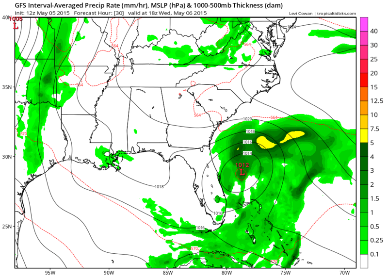
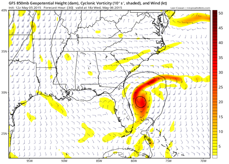
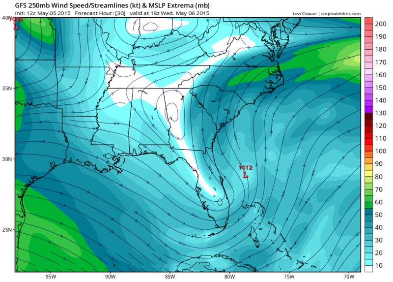
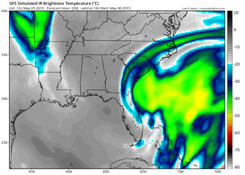
12z GFS's forecast for 18z tomorrow about the time recon will be in the system investigating it.
According to this forecast the system seems to begin acquiring some subtropical characteristics but strongest surface winds could be far from the surface low pressure center.
The posts in this forum are NOT official forecast and should not be used as such. They are just the opinion of the poster and may or may not be backed by sound meteorological data. They are NOT endorsed by any professional institution or storm2k.org. For official information, please refer to the NHC and NWS products
0 likes
-
tropicwatch

- Category 5
- Posts: 3427
- Age: 62
- Joined: Sat Jun 02, 2007 10:01 am
- Location: The Villages, Florida
- Contact:
It would be a weird way to start the season with a sub-tropical named storm 
0 likes
Tropicwatch
Agnes 72', Eloise 75, Elena 85', Kate 85', Charley 86', Florence 88', Beryl 94', Dean 95', Erin 95', Opal 95', Earl 98', Georges 98', Ivan 2004', Arlene 2005', Dennis 2005', Ida 2009' Debby 2012' Irma 2017' Michael 2018'
Agnes 72', Eloise 75, Elena 85', Kate 85', Charley 86', Florence 88', Beryl 94', Dean 95', Erin 95', Opal 95', Earl 98', Georges 98', Ivan 2004', Arlene 2005', Dennis 2005', Ida 2009' Debby 2012' Irma 2017' Michael 2018'
-
TheStormExpert


-
floridasun78
- Category 5
- Posts: 3755
- Joined: Sun May 17, 2009 10:16 pm
- Location: miami fl
Re:
TheStormExpert wrote:Rain has tapered off some here in NE Palm Beach County late this morning/early afternoon. Wouldn't be surprised if we do not manage to get much more measurable rainfall.
[img ]http://fat.gfycat.com/RectangularDisguisedGorilla.gif[/img]
[img ]http://fat.gfycat.com/NimbleTangibleDalmatian.gif[/img]
[img ]http://fat.gfycat.com/WeirdFalseArgali.gif[/img]
still raining here in miami
Last edited by RL3AO on Tue May 05, 2015 12:14 pm, edited 1 time in total.
Reason: Quoted images
Reason: Quoted images
0 likes

Re:
TheStormExpert wrote:Rain has tapered off some here in NE Palm Beach County late this morning/early afternoon. Wouldn't be surprised if we do not manage to get much more measurable rainfall.
Really?? I would think quite the contrary. I would guess that you guys down there (especially coastal Miami-Dade, Broward, & Palm Beach) will be getting "socked" with heavy rain between this afternoon and this evening??
0 likes
Andy D
(For official information, please refer to the NHC and NWS products.)
(For official information, please refer to the NHC and NWS products.)
-
northjaxpro

- S2K Supporter

- Posts: 8900
- Joined: Mon Sep 27, 2010 11:21 am
- Location: Jacksonville, FL
There may be the first signs of a main vort trying to take shape down in the Florida Straits or just to the west of Andros Island. Radar images show decent rotation and convection in that area currently as it drifts very slowly northward.
0 likes
NEVER, EVER SAY NEVER in the tropics and weather in general, and most importantly, with life itself!!
________________________________________________________________________________________
Fay 2008 Beryl 2012 Debby 2012 Colin 2016 Hermine 2016 Julia 2016 Matthew 2016 Irma 2017 Dorian 2019
________________________________________________________________________________________
Fay 2008 Beryl 2012 Debby 2012 Colin 2016 Hermine 2016 Julia 2016 Matthew 2016 Irma 2017 Dorian 2019
Re: Disorganized Convection Across The Bahamas/Cuba
I would think that less volatile upper air conditions might exist for the moment, down towards the Florida Straits... but then again, I have to remind myself that this would perhaps more aptly apply if I were watching for purely tropical development. Though I can also see a bit of a twist in the more convective area just east of Andros Island, as i'm looking at the visible satellite I'd agree with your radar based observation and guess that a center might be trying to form perhaps just west of the Northern tip of Andros.
0 likes
Andy D
(For official information, please refer to the NHC and NWS products.)
(For official information, please refer to the NHC and NWS products.)
Its very important to remember that the strong upper level winds are needed for cyclogenesis to occur. The jets streak to the north of the Bahamas is providing a great deal of upper level divergence where the low is currently or about to form.

This will be a 100% non-tropical system that MAY slowly gain tropical characteristics as the upper low cuts off and creates a more favorable upper level environment for a (sub)tropical cyclone.
This will be a 100% non-tropical system that MAY slowly gain tropical characteristics as the upper low cuts off and creates a more favorable upper level environment for a (sub)tropical cyclone.
0 likes
-
AJC3

- Admin

- Posts: 4156
- Age: 62
- Joined: Tue Aug 31, 2004 7:04 pm
- Location: Ballston Spa, New York
- Contact:
Re:
northjaxpro wrote:There may be the first signs of a main vort trying to take shape down in the Florida Straits or just near or to the west of Andros Island. Radar images show decent rotation and convection in that area currently as it drifts very slowly northward.
The surface METARs show an increasingly better-defined inverted trough, with greater/sharper veering of winds about its axis.

0 likes
Re: Disorganized Convection Across The Bahamas/Cuba
0 likes
Andy D
(For official information, please refer to the NHC and NWS products.)
(For official information, please refer to the NHC and NWS products.)
-
Riptide

- Category 2
- Posts: 753
- Age: 34
- Joined: Fri Jul 23, 2010 3:33 pm
- Location: Cape May, New Jersey
- Contact:
Re: Disorganized Convection Across The Bahamas/Cuba
12z Euro is fairly solid. Hoping someone can post it.
0 likes
-
HurricaneTracker2031
- Tropical Storm

- Posts: 248
- Age: 26
- Joined: Fri Jul 19, 2013 7:20 pm
- Location: Pembroke Pines, FL, USA
- Contact:
Re: Disorganized Convection Across The Bahamas/Cuba
Riptide wrote:12z Euro is fairly solid. Hoping someone can post it.
Here it is in 48hrs

The posts in this forum are NOT official forecast and should not be used as such. They are just the opinion of the poster and may or may not be backed by sound meteorological data. They are NOT endorsed by any professional institution or storm2k.org. For official information, please refer to the NHC and NWS products
0 likes
SHORT VERSION OF DISCLAIMER: THIS SITE LINK BELOW IS NOT AN OFFICIAL FORECASTING OFFICE AND SHOULD NOT BE USED TO MAKE ANY EMERGENCY DECISIONS....
http://www.macstropicalweather.weebly.com
http://www.macstropicalweather.weebly.com
-
StarmanHDB

- Tropical Storm
- Posts: 202
- Age: 61
- Joined: Wed Sep 02, 2009 7:59 pm
- Location: West Palm Beach, Florida
-
HurricaneTracker2031
- Tropical Storm
- Posts: 248
- Age: 26
- Joined: Fri Jul 19, 2013 7:20 pm
- Location: Pembroke Pines, FL, USA
- Contact:
Re: Disorganized Convection Across The Bahamas/Cuba
This area of disturbed weather is still disorganized but it bursting with convection. Models are in agreement and it may be able to form later this week only if it is persistent. We will see.

Synopsis for Atlantic Basin and others: http://goo.gl/PQamgR
The posts in this forum are NOT official forecast and should not be used as such. They are just the opinion of the poster and may or may not be backed by sound meteorological data. They are NOT endorsed by any professional institution or storm2k.org. For official information, please refer to the NHC and NWS products.
0 likes
SHORT VERSION OF DISCLAIMER: THIS SITE LINK BELOW IS NOT AN OFFICIAL FORECASTING OFFICE AND SHOULD NOT BE USED TO MAKE ANY EMERGENCY DECISIONS....
http://www.macstropicalweather.weebly.com
http://www.macstropicalweather.weebly.com
-
floridasun78
- Category 5
- Posts: 3755
- Joined: Sun May 17, 2009 10:16 pm
- Location: miami fl

Re: Surface Trough East of Florida (40% chance of development)
Zoomed satellite loop appears to show that the low has formed or is in the process of forming in the general vicinity of Grand Bahama/Abaco. There is a very faint turn in the low clouds directly south of Abaco with clouds coming out of the W-WNW to the west.
0 likes
The above post is not official and should not be used as such. It is the opinion of the poster and may or may not be backed by sound meteorological data. It is not endorsed by any professional institution or storm2k.org. For official information, please refer to the NHC and NWS products.
Who is online
Users browsing this forum: No registered users and 154 guests