
Thunderstorms overall have been duds most of this week in our region. And not so much the cap holding strong, either we've gotten sloppy convection with lingering clouds or in today's case front outrunning storms.
Next chance will be Sunday-Monday at this one the storm is coming out closer to the state. If not severe weather at least it will have better coverage rainfall than the hit or miss.
Texas Spring-2015
Moderator: S2k Moderators
Forum rules

The posts in this forum are NOT official forecast and should not be used as such. They are just the opinion of the poster and may or may not be backed by sound meteorological data. They are NOT endorsed by any professional institution or STORM2K.
0 likes
The above post and any post by Ntxw is NOT an official forecast and should not be used as such. It is just the opinion of the poster and may or may not be backed by sound meteorological data. It is NOT endorsed by any professional institution including Storm2k. For official information, please refer to NWS products.
Help support Storm2K!
-
aggiecutter
- Category 5

- Posts: 1755
- Joined: Thu Oct 14, 2004 9:22 pm
- Location: Texarkana
Re: Texas Spring-2015
Very strong couplet just east Longview, with gate to gate sheer of 110+
0 likes
-
aggiecutter
- Category 5
- Posts: 1755
- Joined: Thu Oct 14, 2004 9:22 pm
- Location: Texarkana
-
aggiecutter
- Category 5
- Posts: 1755
- Joined: Thu Oct 14, 2004 9:22 pm
- Location: Texarkana
-
Texas Snowman

- Storm2k Moderator

- Posts: 6197
- Joined: Fri Jan 25, 2008 11:29 am
- Location: Denison, Texas
None of this is verified by any means, but a good friend of mine in East Texas says that some friends of his in the Longview area are reporting (not sure of their source(s), maybe local TV?) that there are possibly as many as 14 injuries from the tornado tonight.
And he said that they are saying that there is still a lot of ambulance and emergency vehicle traffic running around in the area.
He also said that an assisted living home may have suffered some damage in Longview, but no injuries were reported. I did see a Internet report that some patients from that home were being evacuated (possibly from damage?).
0 likes
The above post and any post by Texas Snowman is NOT an official forecast and should not be used as such. It is just the opinion of the poster and may or may not be backed by sound meteorological data. It is NOT endorsed by any professional institution including storm2k.org. For official information, please refer to NWS products.
-
weatherdude1108
- Category 5
- Posts: 4228
- Joined: Tue Dec 13, 2011 1:04 pm
- Location: Northwest Austin/Cedar Park, TX
-
Portastorm

- Storm2k Moderator
- Posts: 9955
- Age: 63
- Joined: Fri Jul 11, 2003 9:16 am
- Location: Round Rock, TX
- Contact:
Re:
weatherdude1108 wrote:It is raining finally here at work. Maybe we'll all get free "car washes." Hoping the forecast for more rain in the coming days holds up.
Models and/or forecasters not doing the best job these days. As you know, our last two rain "chances" didn't pan out. This morning we had only a 20% chance and we end up with a vigorous shortwave crossing the state and moving close enough to rain on us! I've been looking alot at the HRRR the last few days and it hasn't done so well.
We need some rain to get all of this crud pollen out of the air.
0 likes
Any forecasts under my name are to be taken with a grain of salt. Get your best forecasts from the National Weather Service and National Hurricane Center.
-
weatherdude1108
- Category 5
- Posts: 4228
- Joined: Tue Dec 13, 2011 1:04 pm
- Location: Northwest Austin/Cedar Park, TX
Re: Re:
Portastorm wrote:weatherdude1108 wrote:It is raining finally here at work. Maybe we'll all get free "car washes." Hoping the forecast for more rain in the coming days holds up.
Models and/or forecasters not doing the best job these days. As you know, our last two rain "chances" didn't pan out. This morning we had only a 20% chance and we end up with a vigorous shortwave crossing the state and moving close enough to rain on us! I've been looking alot at the HRRR the last few days and it hasn't done so well.
We need some rain to get all of this crud pollen out of the air.
Yeah, I'm sick of this green crud coating everything.
I have noticed the models slacking in the rain department, even the HPC's predictions. Starting to take them with a grain of salt.
0 likes
-
TeamPlayersBlue

- Category 5
- Posts: 3531
- Joined: Tue Feb 02, 2010 1:44 am
- Location: Denver/Applewood, CO
Great day for a golf tourney in Magnolia today! We actually may escape according to the HRRR
0 likes
Personal Forecast Disclaimer:
The posts in this forum are NOT official forecast and should not be used as such. They are just the opinion of the poster and may or may not be backed by sound meteorological data. They are NOT endorsed by any professional institution or storm2k.org. For official information, please refer to the NHC and NWS products.
The posts in this forum are NOT official forecast and should not be used as such. They are just the opinion of the poster and may or may not be backed by sound meteorological data. They are NOT endorsed by any professional institution or storm2k.org. For official information, please refer to the NHC and NWS products.
-
Brent
- S2K Supporter

- Posts: 38755
- Age: 37
- Joined: Sun May 16, 2004 10:30 pm
- Location: Tulsa Oklahoma
- Contact:
Re: Texas Spring-2015
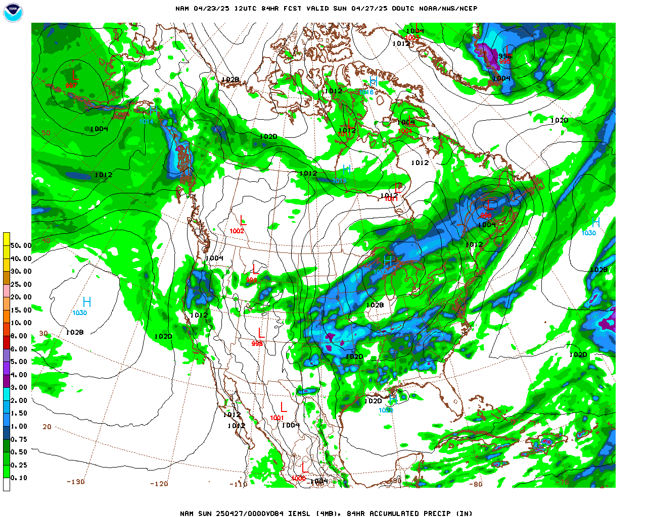
I like the dry spot over DFW. 

The NAM at least is more broad with it :p
But in all seriousness I'm not seeing this heavy rain people are talking about... it feels like another event that is backing off as it approaches.
The NAM at least is more broad with it :p
But in all seriousness I'm not seeing this heavy rain people are talking about... it feels like another event that is backing off as it approaches.
0 likes
#neversummer
-
gboudx

- S2K Supporter
- Posts: 4090
- Joined: Thu Sep 04, 2003 1:39 pm
- Location: Rockwall, Tx but from Harvey, La
Hey dhweather, check this out:
The North Texas Municipal Water District (NTMWD) water supply reservoirs have reached sufficient levels and capacities to allow the District to ease watering restrictions. The NTMWD is the water provider to Rockwall and surrounding cities.
Beginning May 1, 2015, NTMWD will terminate all drought stages and will implement its Water Conservation Plan that allows landscape watering up to two days per week, and only if needed. This action is being implemented in accordance with State and District guidelines.
While the drought has not officially ended, runoff from recent rains helped increase the levels of both Lake Lavon and Lake Chapman, key water supplies for the district. The increasing lake levels along with the resumption of using water from Lake Texoma, the circumstances that caused the initiation of drought stages no longer prevail. Even with termination of drought contingency stages, it's recommended that residents continue to keep their sprinklers off and use the manual mode to irrigate, only if needed.
Rockwall residents are urged to follow these guidelines and remember that watering is not allowed between 10:00 am and 6:00 pm. This provides for the most efficient, cost-effective use of water purchased by customers.
0 likes
-
gboudx
- S2K Supporter
- Posts: 4090
- Joined: Thu Sep 04, 2003 1:39 pm
- Location: Rockwall, Tx but from Harvey, La
Re: Texas Spring-2015
Brent wrote:I like the dry spot over DFW.
My youngest son had a soccer game last evening in Forney, which is south of Rockwall county just north of I-20. We could see the line of dark clouds approaching from the NW. Just as we entered Rockwall city limits, the skies opened and it began pouring. This was on dh's side of Rockwall. We arrived home to dry streets and ground. Not a drop on the northern side of Rockwall, which I'm sure you got a rock as well.
0 likes
-
Brent
- S2K Supporter
- Posts: 38755
- Age: 37
- Joined: Sun May 16, 2004 10:30 pm
- Location: Tulsa Oklahoma
- Contact:
Re: Texas Spring-2015
gboudx wrote:Brent wrote:I like the dry spot over DFW.
My youngest son had a soccer game last evening in Forney, which is south of Rockwall county just north of I-20. We could see the line of dark clouds approaching from the NW. Just as we entered Rockwall city limits, the skies opened and it began pouring. This was on dh's side of Rockwall. We arrived home to dry streets and ground. Not a drop on the northern side of Rockwall, which I'm sure you got a rock as well.
My only rain came from a random noisy thunderstorm at 4am... it was more noise than anything. Only had like .15" in the rain gauge.
Last night.. nada
0 likes
#neversummer
-
weatherdude1108
- Category 5
- Posts: 4228
- Joined: Tue Dec 13, 2011 1:04 pm
- Location: Northwest Austin/Cedar Park, TX
-
Brent
- S2K Supporter
- Posts: 38755
- Age: 37
- Joined: Sun May 16, 2004 10:30 pm
- Location: Tulsa Oklahoma
- Contact:
Re: Texas Spring-2015
The dry hole has grown larger and spread... as the heavier rain continues to shift north and west of the metroplex as we approach the event 

the QPF map is a far cry from the talk of flooding rain

the QPF map is a far cry from the talk of flooding rain
0 likes
#neversummer
-
Texas Snowman
- Storm2k Moderator
- Posts: 6197
- Joined: Fri Jan 25, 2008 11:29 am
- Location: Denison, Texas
NWS says that two EF-1 tornadoes did in fact touch down in East Texas on Thursday night, one in Longview proper and the other a few miles to the NW of Hallsville.
-----
000
NOUS44 KSHV 102251
PNSSHV
ARZ050-051-059>061-070>073-LAZ001>006-010>014-017>022-OKZ077-
TXZ096-097-108>112-124>126-136>138-149>153-165>167-111100-
PUBLIC INFORMATION STATEMENT
NATIONAL WEATHER SERVICE SHREVEPORT LA
551 PM CDT FRI APR 10 2015
...NWS DAMAGE SURVEY FOR APRIL 9 2015 TORNADO EVENT...
.HARRISON TORNADO NEAR THE TOWN OF HALLSVILLE...
RATING: EF-1
ESTIMATED PEAK WIND: 95 - 105 MPH
PATH LENGTH /STATUTE/: 4.54 MILES
PATH WIDTH /MAXIMUM/: 760 YARDS
FATALITIES: NONE
INJURIES: NONE
START DATE: APR 9 2015
START TIME: 720 PM CDT
START LOCATION: 6.5 MILES NW OF HALLSVILLE
START LAT/LON: 32.5465 / -94.6734
END DATE: APR 9 2015
END TIME: 732 PM CDT
END LOCATION: 4.5 MILES NNW OF HALLSVILLE
END_LAT/LON: 32.5655/ -94.5991
.GREGG COUNTY TORNADO NEAR THE TOWN OF LONGVIEW...
RATING: EF-1
ESTIMATED PEAK WIND: 95 - 105 MPH
PATH LENGTH /STATUTE/: 1.32 MILES
PATH WIDTH /MAXIMUM/: 335 YARDS
FATALITIES: NONE
INJURIES: NONE
START DATE: APR 9 2015
START TIME: 710 PM CDT
START LOCATION: 1.75 MILES NE OF DOWNTOWN LONGVIEW
START LAT/LON: 32.5179 / -94.7316
END DATE: APR 9 2015
END TIME: 715 PM CDT
END LOCATION: 2.76 MILES NE OF DOWNTOWN LONGVIEW
END_LAT/LON: 32.5226 / -94.7098
EF SCALE: THE ENHANCED FUJITA SCALE CLASSIFIES TORNADOES INTO
THE FOLLOWING CATEGORIES.
EF0...WEAK......65 TO 85 MPH
EF1...WEAK......86 TO 110 MPH
EF2...STRONG....111 TO 135 MPH
EF3...STRONG....136 TO 165 MPH
EF4...VIOLENT...166 TO 200 MPH
EF5...VIOLENT...>200 MPH
NOTE:
THE INFORMATION IN THIS STATEMENT IS PRELIMINARY AND SUBJECT TO
CHANGE PENDING FINAL REVIEW OF THE EVENT AND PUBLICATION IN
NWS STORM DATA.
$$
0 likes
The above post and any post by Texas Snowman is NOT an official forecast and should not be used as such. It is just the opinion of the poster and may or may not be backed by sound meteorological data. It is NOT endorsed by any professional institution including storm2k.org. For official information, please refer to NWS products.
-
Brent
- S2K Supporter
- Posts: 38755
- Age: 37
- Joined: Sun May 16, 2004 10:30 pm
- Location: Tulsa Oklahoma
- Contact:
Re: Texas Spring-2015
and now the models go back wet again... widespread good amounts... lol.
I'll still believe it when I see it

I'll still believe it when I see it
0 likes
#neversummer
-
Rgv20

- S2K Supporter
- Posts: 2466
- Age: 39
- Joined: Wed Jan 05, 2011 5:42 pm
- Location: Edinburg/McAllen Tx
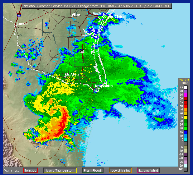
Maybe I miss tropical season a bit too much but in the radar snapshot it sure does look like a tropical system! This past 2 nights we sure have seen some beneficial rains and it looks like Sunday Evening/Night will be a repeat.

0 likes
The following post is NOT an official forecast and should not be used as such. It is just the opinion of the poster and may or may not be backed by sound meteorological data. It is NOT endorsed by any professional institution including storm2k.org For Official Information please refer to the NHC and NWS products.
-
TeamPlayersBlue
- Category 5
- Posts: 3531
- Joined: Tue Feb 02, 2010 1:44 am
- Location: Denver/Applewood, CO
Looks like an MCV. That downpour in Houston last night was pretty intense.
0 likes
Personal Forecast Disclaimer:
The posts in this forum are NOT official forecast and should not be used as such. They are just the opinion of the poster and may or may not be backed by sound meteorological data. They are NOT endorsed by any professional institution or storm2k.org. For official information, please refer to the NHC and NWS products.
The posts in this forum are NOT official forecast and should not be used as such. They are just the opinion of the poster and may or may not be backed by sound meteorological data. They are NOT endorsed by any professional institution or storm2k.org. For official information, please refer to the NHC and NWS products.
-
aggiecutter
- Category 5
- Posts: 1755
- Joined: Thu Oct 14, 2004 9:22 pm
- Location: Texarkana
Re: Texas Spring-2015
This is from the Shreveport AFD, but might be of interest to those in Central Texas:
HRR SUGGESTING A SQUALL
LINE MOVG ACROSS CENTRAL TX EASTWARD AT 06Z TONIGHT
HRR SUGGESTING A SQUALL
LINE MOVG ACROSS CENTRAL TX EASTWARD AT 06Z TONIGHT
0 likes
Return to “USA & Caribbean Weather”
Who is online
Users browsing this forum: No registered users and 112 guests