Texas Spring-2015
Moderator: S2k Moderators
Forum rules
The posts in this forum are NOT official forecast and should not be used as such. They are just the opinion of the poster and may or may not be backed by sound meteorological data. They are NOT endorsed by any professional institution or STORM2K.
-
aggiecutter
- Category 5

- Posts: 1755
- Joined: Thu Oct 14, 2004 9:22 pm
- Location: Texarkana
Re: Texas Spring-2015
0 likes
-
weatherdude1108
- Category 5

- Posts: 4228
- Joined: Tue Dec 13, 2011 1:04 pm
- Location: Northwest Austin/Cedar Park, TX
Re: Texas Spring-2015
0 likes
- TeamPlayersBlue
- Category 5

- Posts: 3531
- Joined: Tue Feb 02, 2010 1:44 am
- Location: Denver/Applewood, CO
Since ive been on this forum, ive realized that its not all about Nino or Nina. The PDO is a huge factor. Look at 2010-11. That year was very cold for us then slipped into a raging drought. Loving the Nino right now, but curious to see what happens to the warm water off the coast of CA. Hopefully next year they can get the Nino with lots of rain and snow.
Also, might be the wrong forum, someone posted the latitude of the moon as an indicator of Nino/Nina approaching i think this is fascinating stuff. Any other research on this?
Also, might be the wrong forum, someone posted the latitude of the moon as an indicator of Nino/Nina approaching i think this is fascinating stuff. Any other research on this?
0 likes
Personal Forecast Disclaimer:
The posts in this forum are NOT official forecast and should not be used as such. They are just the opinion of the poster and may or may not be backed by sound meteorological data. They are NOT endorsed by any professional institution or storm2k.org. For official information, please refer to the NHC and NWS products.
The posts in this forum are NOT official forecast and should not be used as such. They are just the opinion of the poster and may or may not be backed by sound meteorological data. They are NOT endorsed by any professional institution or storm2k.org. For official information, please refer to the NHC and NWS products.
-
aggiecutter
- Category 5

- Posts: 1755
- Joined: Thu Oct 14, 2004 9:22 pm
- Location: Texarkana
Re: Texas Spring-2015
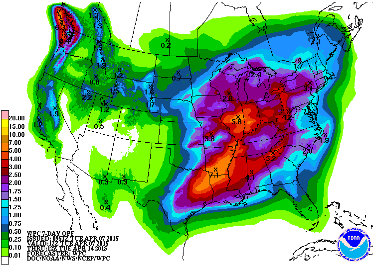
Amazing how sharply that drops off from East Texas as you move west to the I-35 corridor.
0 likes
The above post and any post by dhweather is NOT an official forecast and should not be used as such. It is just the opinion of the poster and may or may not be backed by sound meteorological data. It is NOT endorsed by any professional institution including storm2k.org. For official information, please refer to NWS products.
Re:
Ntxw wrote:Before we worry about cap and cinh next week enjoy the 0.50 to 1 inch cool rains tomorrow. As for next week things will be very unstable but the cap will be strong. If one of two things happen; either the temperature needs to get really hot or we get sufficient lift. Likely biggest outbreak of the year up to the north from OKC to Nebraska closer to lift.
0.8" in Heath on Sunday, which was a big surprise. Liquid gold is ALWAYS welcome here
0 likes
The above post and any post by dhweather is NOT an official forecast and should not be used as such. It is just the opinion of the poster and may or may not be backed by sound meteorological data. It is NOT endorsed by any professional institution including storm2k.org. For official information, please refer to NWS products.
The models have consistently put out healthy rain totals for much of the eastern half of the state for the month of April, even if only half comes true many will be very happy. Analog years suggest a wet rest of the way through May. Severe weather while happening some is still not as impressive as it could be, we shall see on that end.
0 likes
The above post and any post by Ntxw is NOT an official forecast and should not be used as such. It is just the opinion of the poster and may or may not be backed by sound meteorological data. It is NOT endorsed by any professional institution including Storm2k. For official information, please refer to NWS products.
- vbhoutex
- Storm2k Executive

- Posts: 29149
- Age: 74
- Joined: Wed Oct 09, 2002 11:31 pm
- Location: Cypress, TX
- Contact:
Re: Texas Spring-2015
Jeff's morning email suggests some stormy days ahead.
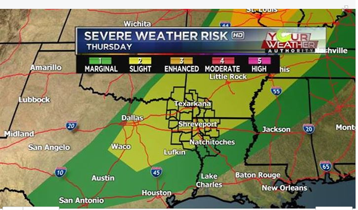
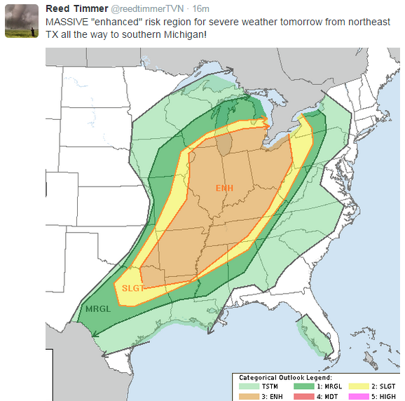
First upper level storm system ejects out of the SW US and toward the central plains with a trailing cold front moving into the area late Thursday and on Friday and stalling. Air mass south of this front Thursday afternoon becomes moderately unstable with forecasted CAPE values of 1500-2500 J/kg and steepening lapse rates aloft. Surface heating into the mid 80’s will help to erode the weakening aping inversion and expect at least isolated storms to develop along the front. Any storms that develop will pose a hail and damaging wind threat with the best chances from College Station to Lufkin Thursday evening.
Front sags southward on Friday and expect another active convective day Friday afternoon. Weak short wave will cross the area in combination with the surface front likely producing scattered thunderstorms in the heat of the afternoon. Guidance is really pegging Friday afternoon/evening to be fairly active. Again the air mass will be fairly unstable and strong to severe thunderstorms will be possible. Shear profiles are not overly favorable for tornado production, but large hail and wind damage appear the main threats. SPC has already outlooked much of the area for a slight risk of severe weather Friday afternoon.
Saturday:
Front remains stalled across the region and this will linger thunderstorm chances all day Saturday. Think the best chances will be in the afternoon hours with surface heating, but much of this depends on how much development there is Friday afternoon and if the air mass is “worked over” and needs time to recharge.
Sunday/Monday:
Much stronger and deeper upper level system approaches the region Sunday and Monday and this system will certainly bring impacts if the current model projections hold. Old surface front will move northward as a warm front on Sunday and with lift increasing, showers and thunderstorms will once again erupt along and north of this boundary. Severe weather will be possible Sunday afternoon with increasing instability and shear values.
Main upper level system moves across the area late Sunday into Monday with numerous thunderstorms expected. Threat may transition from severe weather to heavy rainfall and flash flooding especially given the increasing saturated grounds after severe rounds of thunderstorms. Latest model guidance really pegs the area Sunday night into Monday morning with heavy rainfall and several flash flood factors appear favorable during this period including a good feed of moisture off the Gulf, a slow moving boundary, and exceptionally high moisture content of the air mass (PWS nearing 1.7 inches). Will also support a severe threat with a favorable splitting jet stream structure aloft and cooler mid level temperatures advecting over the warm surface air mass. Main threats appear to be large hail and wind damage, but tornadoes may also be possible.
0 likes
- TeamPlayersBlue
- Category 5

- Posts: 3531
- Joined: Tue Feb 02, 2010 1:44 am
- Location: Denver/Applewood, CO
The HRRR is showing some big storms, looks to be supercell nature in SE Kansas, NE Oklahoma. Very muggy it seems there.
0 likes
Personal Forecast Disclaimer:
The posts in this forum are NOT official forecast and should not be used as such. They are just the opinion of the poster and may or may not be backed by sound meteorological data. They are NOT endorsed by any professional institution or storm2k.org. For official information, please refer to the NHC and NWS products.
The posts in this forum are NOT official forecast and should not be used as such. They are just the opinion of the poster and may or may not be backed by sound meteorological data. They are NOT endorsed by any professional institution or storm2k.org. For official information, please refer to the NHC and NWS products.
- wxman57
- Moderator-Pro Met

- Posts: 23175
- Age: 68
- Joined: Sat Jun 21, 2003 8:06 pm
- Location: Houston, TX (southwest)
Re: Texas Spring-2015
A group of us (including katdaddy from League City) have arrived in Harlingen and are on our way to the National Tropical Weather Conference on S. Padre Island. See the photo below. Srain is on his way down here shortly. Phil Klotzbach is on his flight.
https://imageshack.com/i/pcCbtJk5j
https://imageshack.com/i/pcCbtJk5j
0 likes
- Tireman4
- S2K Supporter

- Posts: 5903
- Age: 60
- Joined: Fri Jun 30, 2006 1:08 pm
- Location: Humble, Texas
- Contact:
Re: Texas Spring-2015
wxman57 wrote:A group of us (including katdaddy from League City) have arrived in Harlingen and are on our way to the National Tropical Weather Conference on S. Padre Island. See the photo below. Srain is on his way down here shortly. Phil Klotzbach is on his flight.
https://imageshack.com/i/pcCbtJk5j
A limo? A limo? Sigh.....LOL...Party time...LOL
0 likes
- TheProfessor
- Professional-Met

- Posts: 3506
- Age: 29
- Joined: Tue Dec 03, 2013 10:56 am
- Location: Wichita, Kansas
- wxman57
- Moderator-Pro Met

- Posts: 23175
- Age: 68
- Joined: Sat Jun 21, 2003 8:06 pm
- Location: Houston, TX (southwest)
Re: Texas Spring-2015
Tireman4 wrote:wxman57 wrote:A group of us (including katdaddy from League City) have arrived in Harlingen and are on our way to the National Tropical Weather Conference on S. Padre Island. See the photo below. Srain is on his way down here shortly. Phil Klotzbach is on his flight.
https://imageshack.com/i/pcCbtJk5j
A limo? A limo? Sigh.....LOL...Party time...LOL
Yeah, and it's full of beer. Too bad I don't drink.
https://imageshack.com/i/idywv2Guj
0 likes
- wxman57
- Moderator-Pro Met

- Posts: 23175
- Age: 68
- Joined: Sat Jun 21, 2003 8:06 pm
- Location: Houston, TX (southwest)
Re:
gboudx wrote:I recognize you from the vids, but is jeff one of you? I don't remember what he looks like though I know I saw him giving briefings during Ike.
I don't think that Jeff is attending.
0 likes
- TeamPlayersBlue
- Category 5

- Posts: 3531
- Joined: Tue Feb 02, 2010 1:44 am
- Location: Denver/Applewood, CO
Nice! You guys have fun!
0 likes
Personal Forecast Disclaimer:
The posts in this forum are NOT official forecast and should not be used as such. They are just the opinion of the poster and may or may not be backed by sound meteorological data. They are NOT endorsed by any professional institution or storm2k.org. For official information, please refer to the NHC and NWS products.
The posts in this forum are NOT official forecast and should not be used as such. They are just the opinion of the poster and may or may not be backed by sound meteorological data. They are NOT endorsed by any professional institution or storm2k.org. For official information, please refer to the NHC and NWS products.
-
aggiecutter
- Category 5

- Posts: 1755
- Joined: Thu Oct 14, 2004 9:22 pm
- Location: Texarkana
-
aggiecutter
- Category 5

- Posts: 1755
- Joined: Thu Oct 14, 2004 9:22 pm
- Location: Texarkana
- Tireman4
- S2K Supporter

- Posts: 5903
- Age: 60
- Joined: Fri Jun 30, 2006 1:08 pm
- Location: Humble, Texas
- Contact:
Return to “USA & Caribbean Weather”
Who is online
Users browsing this forum: No registered users and 152 guests


