Texas Winter 2014-2015
Moderator: S2k Moderators
Forum rules
 The posts in this forum are NOT official forecast and should not be used as such. They are just the opinion of the poster and may or may not be backed by sound meteorological data. They are NOT endorsed by any professional institution or STORM2K.

The posts in this forum are NOT official forecast and should not be used as such. They are just the opinion of the poster and may or may not be backed by sound meteorological data. They are NOT endorsed by any professional institution or STORM2K.

-
TeamPlayersBlue

- Category 5

- Posts: 3524
- Joined: Tue Feb 02, 2010 1:44 am
- Location: Denver/Applewood, CO
Also, i think the High, if its that big, will bleed south regardless. May not bring all of the funk down but it will be strong.
Look at that dewpoint for IAH in the chart WXMan posted. Below zero. Goodness. Lets see what the other models show. We got the cold, now we need the STJ to come and play.
All these constant cloudy days there has to be some kind of moisture out there!
Look at that dewpoint for IAH in the chart WXMan posted. Below zero. Goodness. Lets see what the other models show. We got the cold, now we need the STJ to come and play.
All these constant cloudy days there has to be some kind of moisture out there!
0 likes
Personal Forecast Disclaimer:
The posts in this forum are NOT official forecast and should not be used as such. They are just the opinion of the poster and may or may not be backed by sound meteorological data. They are NOT endorsed by any professional institution or storm2k.org. For official information, please refer to the NHC and NWS products.
The posts in this forum are NOT official forecast and should not be used as such. They are just the opinion of the poster and may or may not be backed by sound meteorological data. They are NOT endorsed by any professional institution or storm2k.org. For official information, please refer to the NHC and NWS products.
Re:
Snowman67 wrote:I'm headed up to the Little Rock area on New Years Eve. What are the models showing for that area in the 12/31 - 1/2 time frame? Thanks.
12z GFS is cold, below freezing throughout the period with limited precip, low of 8F on that model.
0 likes
-
wxman57

- Moderator-Pro Met

- Posts: 23170
- Age: 68
- Joined: Sat Jun 21, 2003 8:06 pm
- Location: Houston, TX (southwest)
Re:
Snowman67 wrote:I'm headed up to the Little Rock area on New Years Eve. What are the models showing for that area in the 12/31 - 1/2 time frame? Thanks.
No issues indicated with the 12z GFS in Little Rock. Clear and cold (very cold) up there. Of course, lots of uncertainty for your departure out of Tomball. Check back in 6-7 days...
0 likes
-
TeamPlayersBlue
- Category 5
- Posts: 3524
- Joined: Tue Feb 02, 2010 1:44 am
- Location: Denver/Applewood, CO
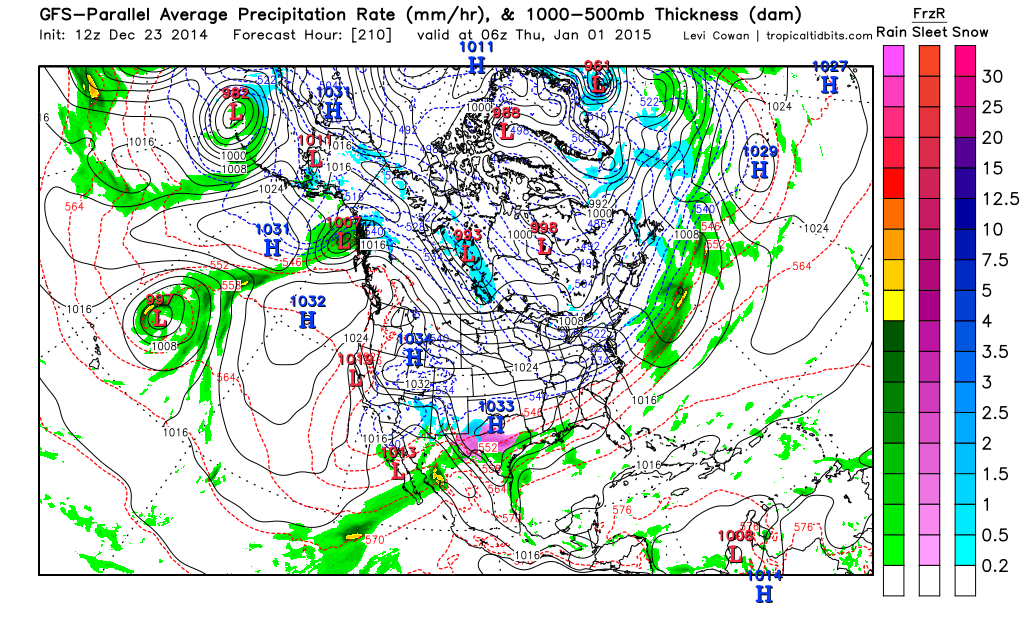
So the PGFS is showing a big ice storm for the hill country, staying just west of SE Tx. Looks kinda strange. It has a Low out west but maybe a bit further west than we would like.Keeps it mostly rain for SE Tx, but winter precip over the hill country. Not sure if i completely agree with it even though im biased. It closes off an upper level low out west and isnt as cold as the GFS.

0 likes
Personal Forecast Disclaimer:
The posts in this forum are NOT official forecast and should not be used as such. They are just the opinion of the poster and may or may not be backed by sound meteorological data. They are NOT endorsed by any professional institution or storm2k.org. For official information, please refer to the NHC and NWS products.
The posts in this forum are NOT official forecast and should not be used as such. They are just the opinion of the poster and may or may not be backed by sound meteorological data. They are NOT endorsed by any professional institution or storm2k.org. For official information, please refer to the NHC and NWS products.
-
orangeblood
- S2K Supporter

- Posts: 3895
- Joined: Tue Dec 15, 2009 6:14 pm
- Location: Fort Worth, TX
Re: Texas Winter 2014-2015
0 likes
-
TeamPlayersBlue
- Category 5
- Posts: 3524
- Joined: Tue Feb 02, 2010 1:44 am
- Location: Denver/Applewood, CO
Re: Texas Winter 2014-2015
orangeblood wrote::uarrow: Yep - The GFS and Parallel are flip flopping. TeamPlayersBlue, trust me, you want energy to dig into the southwest like that to increase your winter weather chances in your neighborhood. The cold will be there with that kind of massive HP sliding down the lee side of the Rockies like that - the Parallel erodes the dense cold air way too quickly.
0 likes
Personal Forecast Disclaimer:
The posts in this forum are NOT official forecast and should not be used as such. They are just the opinion of the poster and may or may not be backed by sound meteorological data. They are NOT endorsed by any professional institution or storm2k.org. For official information, please refer to the NHC and NWS products.
The posts in this forum are NOT official forecast and should not be used as such. They are just the opinion of the poster and may or may not be backed by sound meteorological data. They are NOT endorsed by any professional institution or storm2k.org. For official information, please refer to the NHC and NWS products.


Re: Re:
wxman57 wrote:Snowman67 wrote:I'm headed up to the Little Rock area on New Years Eve. What are the models showing for that area in the 12/31 - 1/2 time frame? Thanks.
No issues indicated with the 12z GFS in Little Rock. Clear and cold (very cold) up there. Of course, lots of uncertainty for your departure out of Tomball. Check back in 6-7 days...
wxman57 when can we start to believe the model output.
0 likes

Re: Texas Winter 2014-2015
Boy, if this pans out, OUCH.

0 likes
The above post and any post by dhweather is NOT an official forecast and should not be used as such. It is just the opinion of the poster and may or may not be backed by sound meteorological data. It is NOT endorsed by any professional institution including storm2k.org. For official information, please refer to NWS products.


You want STJ? Major SOI crash going on right now.
0 likes
The above post and any post by Ntxw is NOT an official forecast and should not be used as such. It is just the opinion of the poster and may or may not be backed by sound meteorological data. It is NOT endorsed by any professional institution including Storm2k. For official information, please refer to NWS products.
Help support Storm2K!
-
orangeblood
- S2K Supporter
- Posts: 3895
- Joined: Tue Dec 15, 2009 6:14 pm
- Location: Fort Worth, TX
Re: Texas Winter 2014-2015
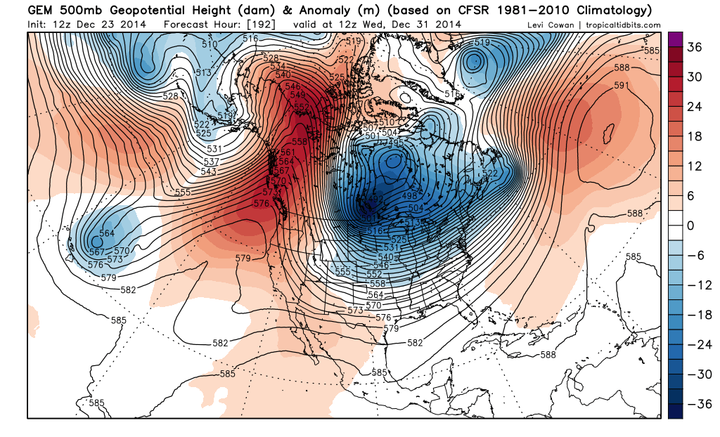
Portastorm wrote:Watching the 12z GFS op run roll in now. At 192 hours (6z on 12/31), it brings a 1052 mb high into west central Montana. Classic trajectory for spilling Arctic air down the leeside of the Rockies and into Texas. The question is: how cold will the source region air be?
Portastorm - to answer your question about source region, most all models take the air currently sitting over Northeastern Siberia (top left of the image below) and discharge it directly into the lower 48 down into our neighborhoods next week. This air has Vodka written all over it, might even be a little discounted if you've seen what the Russian Ruble has been up to lately!

0 likes

Re: Texas Winter 2014-2015
orangeblood wrote:Portastorm wrote:Watching the 12z GFS op run roll in now. At 192 hours (6z on 12/31), it brings a 1052 mb high into west central Montana. Classic trajectory for spilling Arctic air down the leeside of the Rockies and into Texas. The question is: how cold will the source region air be?
Portastorm - to answer your question about source region, most all models take the air currently sitting over Northeastern Siberia (top left of the image below) and discharge it directly into the lower 48 down into our neighborhoods next week. This air has Vodka written all over it, might even be a little discounted if you've seen what the Russian Ruble has been up to lately!
Thanks for confirming what I thought I heard, wanted to be sure I wasn't dreaming.
0 likes
Any opinions stated are those of an amateur, please take with several grains of salt and for official forecast refer to the National Weather Service.
-
orangeblood
- S2K Supporter
- Posts: 3895
- Joined: Tue Dec 15, 2009 6:14 pm
- Location: Fort Worth, TX
Re:
Ntxw wrote:You want STJ? Major SOI crash going on right now.
When's the last time we've had an SOI crash of this magnitude ? 2009-2010 winter ?
0 likes
-
Ralph's Weather
- S2K Supporter
- Posts: 3371
- Age: 38
- Joined: Fri Dec 13, 2013 11:55 am
- Location: Lindale, TX
- Contact:
Re:
Ntxw wrote:You want STJ? Major SOI crash going on right now.
That plus cross polar flow would be amazing for us in Texas.
0 likes
Follow on Facebook at Ralph's Weather.
-
TeamPlayersBlue
- Category 5
- Posts: 3524
- Joined: Tue Feb 02, 2010 1:44 am
- Location: Denver/Applewood, CO
SOI crash have to do with the MJO coming back too life?
0 likes
Personal Forecast Disclaimer:
The posts in this forum are NOT official forecast and should not be used as such. They are just the opinion of the poster and may or may not be backed by sound meteorological data. They are NOT endorsed by any professional institution or storm2k.org. For official information, please refer to the NHC and NWS products.
The posts in this forum are NOT official forecast and should not be used as such. They are just the opinion of the poster and may or may not be backed by sound meteorological data. They are NOT endorsed by any professional institution or storm2k.org. For official information, please refer to the NHC and NWS products.
-
TeamPlayersBlue
- Category 5
- Posts: 3524
- Joined: Tue Feb 02, 2010 1:44 am
- Location: Denver/Applewood, CO
Canadian. 


0 likes
Personal Forecast Disclaimer:
The posts in this forum are NOT official forecast and should not be used as such. They are just the opinion of the poster and may or may not be backed by sound meteorological data. They are NOT endorsed by any professional institution or storm2k.org. For official information, please refer to the NHC and NWS products.
The posts in this forum are NOT official forecast and should not be used as such. They are just the opinion of the poster and may or may not be backed by sound meteorological data. They are NOT endorsed by any professional institution or storm2k.org. For official information, please refer to the NHC and NWS products.
-
orangeblood
- S2K Supporter
- Posts: 3895
- Joined: Tue Dec 15, 2009 6:14 pm
- Location: Fort Worth, TX
Re:
TeamPlayersBlue wrote:SOI crash have to do with the MJO coming back too life?
Ntxw can get more in depth with you about this but typically the usual indices of interannual variability of the MJO are uncorrelated with measures of the ENSO cycle.
0 likes
Re: Re:
wxman57 wrote:Snowman67 wrote:I'm headed up to the Little Rock area on New Years Eve. What are the models showing for that area in the 12/31 - 1/2 time frame? Thanks.
No issues indicated with the 12z GFS in Little Rock. Clear and cold (very cold) up there. Of course, lots of uncertainty for your departure out of Tomball. Check back in 6-7 days...
Thanks 57 and Ronyan! I'll check back next week to see what it looks like.
0 likes
Any forecast I make is based on my opinion only. Please refer to the NWS or NHC for official forecasts.
-
gatorcane

- S2K Supporter
- Posts: 23708
- Age: 48
- Joined: Sun Mar 13, 2005 3:54 pm
- Location: Boca Raton, FL


-
gatorcane
- S2K Supporter
- Posts: 23708
- Age: 48
- Joined: Sun Mar 13, 2005 3:54 pm
- Location: Boca Raton, FL
12Z ECMWF rolling, looks like it is trying to shunt the core of the artic air more to the Southeast than the 00Z run though still cold for Texas...out through 168 hours so far. Huge Artic high pressure diving south folks....models trending colder for this artic blast event for the continental United States.

Last edited by gatorcane on Tue Dec 23, 2014 1:49 pm, edited 1 time in total.
0 likes
Who is online
Users browsing this forum: No registered users and 82 guests