
Texas Winter 2014-2015
Moderator: S2k Moderators
Forum rules
 The posts in this forum are NOT official forecast and should not be used as such. They are just the opinion of the poster and may or may not be backed by sound meteorological data. They are NOT endorsed by any professional institution or STORM2K.

The posts in this forum are NOT official forecast and should not be used as such. They are just the opinion of the poster and may or may not be backed by sound meteorological data. They are NOT endorsed by any professional institution or STORM2K.
-
Rgv20

- S2K Supporter

- Posts: 2466
- Age: 39
- Joined: Wed Jan 05, 2011 5:42 pm
- Location: Edinburg/McAllen Tx
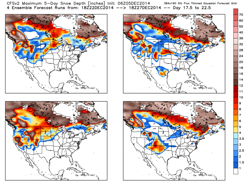
Well I would surely take the top right run of the CFS! This are the Snowfall forecast from the CFSv2 from the December 22 to 27!
0 likes
The following post is NOT an official forecast and should not be used as such. It is just the opinion of the poster and may or may not be backed by sound meteorological data. It is NOT endorsed by any professional institution including storm2k.org For Official Information please refer to the NHC and NWS products.

-
TeamPlayersBlue

- Category 5

- Posts: 3533
- Joined: Tue Feb 02, 2010 1:44 am
- Location: Denver/Applewood, CO
Yeah i remember last year having numerous warm spells, then BOOM, big shot of cold. Not worried.
0 likes
Personal Forecast Disclaimer:
The posts in this forum are NOT official forecast and should not be used as such. They are just the opinion of the poster and may or may not be backed by sound meteorological data. They are NOT endorsed by any professional institution or storm2k.org. For official information, please refer to the NHC and NWS products.
The posts in this forum are NOT official forecast and should not be used as such. They are just the opinion of the poster and may or may not be backed by sound meteorological data. They are NOT endorsed by any professional institution or storm2k.org. For official information, please refer to the NHC and NWS products.

Re:
weatherdude1108 wrote:Here's Hampshire's afternoon discussion.
I am honored that the EWX office has its own "Cavanaugh"
I like the practicality of his last sentence ("ALL
IN ALL THIS WILL BE CLOSE TO SEASONAL NORMALS AND NOT TOO BAD FOR
THIS TIME OF THE YEAR"). Hope he doesn't leave us. Happy Friday!!
00
FXUS64 KEWX 052109
AFDEWX
AREA FORECAST DISCUSSION
NATIONAL WEATHER SERVICE AUSTIN/SAN ANTONIO TX
309 PM CST FRI DEC 5 2014
.SHORT TERM (TONIGHT THROUGH SATURDAY NIGHT)...
LOW CLOUDS CONTINUE TO BE IN PLACE FOR MOST OF THE REGION WITH THE
CLEARING LINE CURRENTLY EXTENDING FROM DEL RIO TO BURNET. THE
KDFX VAD WIND PROFILE HAS BEEN INDICATING VEERING WINDS ALOFT WITH
NORTH FLOW NOW PRESENT ABOVE 4KFT. THIS IS INDICATIVE OF DRYING
AIR ALOFT WHICH SHOULD SLOWLY CONTINUE TO PUSH THE CLEARING LINE
TO THE SOUTHEAST. THE WIND SHIFT ALOFT IS IN ASSOCIATION WITH A
TROUGH AXIS THAT IS PUSHING EAST OF THE AREA. THIS TROUGH WILL
SEND A WEAK COLD FRONT INTO THE CWA LATE THIS EVENING AND
OVERNIGHT. CURRENTLY THE FRONT WAS LOCATED NEAR A MIDLAND TO
WICHITA FALLS TO OKLAHOMA CITY LINE. THIS FRONT WILL HAVE LITTLE
EFFECT WITH THE MORNING LOWS OR HIGH TEMPERATURES TOMORROW. HIGHS
TOMORROW WILL REACH THE MIDDLE 60S TO LOWER 70S WHICH IS ABOUT A 5
DEGREE DROP ON AVERAGE IN COMPARISON TO TODAY. THERE IS THE
POTENTIAL FOR FOG OR AN ISOLATED SHOWER BEFORE THE FRONT MOVES IN
TONIGHT FOR THE SOUTHEASTERN COUNTIES. THE SOUTHWEST AND WESTERLY
FLOW JUST OFF THE SURFACE SHOULD LIMIT DENSE FOG POTENTIAL. TOMORROW
AND TOMORROW NIGHT SHOULD BE DRY AS SUBSIDENCE TAKES A HOLD AS A
WEAK RIDGE AXIS QUICKLY SLIDES OVER THE REGION BEHIND THE TROUGH.
&&
.LONG TERM (SUNDAY THROUGH FRIDAY)...
THE WEAK RIDGE AXIS WILL QUICKLY SLIDE EAST BY SUNDAY AS ANOTHER
TROUGH MOVES THROUGH THE SOUTHERN PLAINS. MODELS HAVE SOME
DISAGREEMENT REGARDING THE AMOUNT OF MOISTURE AND INSTABILITY
AVAILABLE FOR SHOWER PRODUCTION. THE GFS/ECMWF SHOW A WEAK CAP
AROUND 700 MB THAT WOULD KEEP ANY PRECIPITATION PROCESSES IN THE
LOWEST 3KM OF THE ATMOSPHERE. THIS WOULD THEN LIMIT THE COVERAGE
AND AMOUNTS OF PRECIP. THE NAM DOES NOT SHOW THIS INVERSION AND
THUS HAS MUCH MORE QPF IN THE RAW MODEL OUTPUT. WILL CONTINUE TO
FORECAST AROUND A 30 POP FOR SUNDAY AND SUNDAY NIGHT. EVEN IF THE
NAM VERIFIES AVERAGE PRECIP AMOUNTS WILL GENERALLY BE LESS THAN 2
TENTHS OF AN INCH.
WEAK RIDGING RETURNS MONDAY BEHIND THE SHORTWAVE WHICH SHOULD END
PRECIP CHANCES FOR MOST OF THE AREA. THERE COULD BE SOME LIGHT
RAIN OF DRIZZLE CLOSER TO THE RIO GRANDE WHERE THERE IS BETTER
LOW-LEVEL LAPSE RATES IN A SATURATED LAYER UP TO 800 MB. SEVERAL
WEAK TROUGHS EMBEDDED IN NEARLY ZONAL FLOW WILL LEAD TO CONTINUED
RAIN CHANCES FOR MUCH OF THE CWA TUESDAY THROUGH THURSDAY. FORCING
WILL REMAIN WEAK AND MOISTURE LIMITED...AND AM NOT EXPECTING MUCH
IN THE WAY OF RAIN AMOUNTS. SURFACE FLOW WILL REMAIN SOUTHERLY
WITH TEMPERATURES IN THE 60S FOR HIGHS AND 40S/50S FOR LOWS. ALL
IN ALL THIS WILL BE CLOSE TO SEASONAL NORMALS AND NOT TOO BAD FOR
THIS TIME OF THE YEAR.
HAMPSHIRE
Nick Hampshire was at FWD and worked with Dennis Cavanaugh. That is fertile ground of weather intelligence in Fort Worth.
0 likes
The above post and any post by dhweather is NOT an official forecast and should not be used as such. It is just the opinion of the poster and may or may not be backed by sound meteorological data. It is NOT endorsed by any professional institution including storm2k.org. For official information, please refer to NWS products.
-
orangeblood
- S2K Supporter
- Posts: 3895
- Joined: Tue Dec 15, 2009 6:14 pm
- Location: Fort Worth, TX
Re: Re:
srainhoutx wrote:Portastorm wrote:gatorcane wrote:The 12Z ECMWF shows nothing but much warmer anomalies for most of the lower 48 and Southern Canada through 10 days.
Sorry but that's not entirely accurate. Days 9-10 of the 12z Euro run show normal to below normal for much of the western half of the CONUS.
It also noteworthy that the 12Z ECMWF suggests the West Coast trough slowly moving E which tend it agree with the OP GFS and GEFS meaning that pattern is beginning to shift. I believe we are on schedule to see an active colder regime along and E of the Continental Divide as we transition in the Christmas Holiday timeframe.
Yeah, now we have both the European and GFS ensembles going to a Major Pattern Change starting around the December 18-20th time frame
0 likes
-
gatorcane

- S2K Supporter
- Posts: 23708
- Age: 48
- Joined: Sun Mar 13, 2005 3:54 pm
- Location: Boca Raton, FL
Re: Re:
Portastorm wrote:gatorcane wrote:The 12Z ECMWF shows nothing but much warmer anomalies for most of the lower 48 and Southern Canada through 10 days.
Sorry but that's not entirely accurate. Days 9-10 of the 12z Euro run show normal to below normal for much of the western half of the CONUS.
Technically yes you are right, but the point is no arctic intrusions through 10 days though the long-range is subject to change.
0 likes

Paradigm shift by mid December showing up on ensembles. Cross polar flow may try to set up and we keep sig low heights blocking over the top look. Winter cancel; canceled. I would say around the 15th it starts to change and kicks in near full gear Christmas week if things progress.
0 likes
The above post and any post by Ntxw is NOT an official forecast and should not be used as such. It is just the opinion of the poster and may or may not be backed by sound meteorological data. It is NOT endorsed by any professional institution including Storm2k. For official information, please refer to NWS products.
Help support Storm2K!
-
Nairobi
Per the operational and ensembles ECMWF, no arctic air in Texas for the next 10 days. Possibly stormy towards the end of that period.
GFS showing no freezes for Austin or Dallas during the next 16 days and no upstream hint of one for the few days after that.
CFS also not showing any arctic air for Texas through the end of the month.
GFS showing no freezes for Austin or Dallas during the next 16 days and no upstream hint of one for the few days after that.
CFS also not showing any arctic air for Texas through the end of the month.
0 likes
-
Portastorm

- Storm2k Moderator

- Posts: 9955
- Age: 63
- Joined: Fri Jul 11, 2003 9:16 am
- Location: Round Rock, TX
- Contact:
Re:
Nairobi wrote:Per the operational and ensembles ECMWF, no arctic air in Texas for the next 10 days. Possibly stormy towards the end of that period.
GFS showing no freezes for Austin or Dallas during the next 16 days and no upstream hint of one for the few days after that.
CFS also not showing any arctic air for Texas through the end of the month.
Well, it's very evident that you are not buying into any "winter" impacting Texas. That very well may be. As I've mentioned repeatedly most of the longer-range prognostications from pro mets indicated December would be mostly warm and that things turn in early January.
0 likes
Any forecasts under my name are to be taken with a grain of salt. Get your best forecasts from the National Weather Service and National Hurricane Center.

Re: Re:
Portastorm wrote:Nairobi wrote:Per the operational and ensembles ECMWF, no arctic air in Texas for the next 10 days. Possibly stormy towards the end of that period.
GFS showing no freezes for Austin or Dallas during the next 16 days and no upstream hint of one for the few days after that.
CFS also not showing any arctic air for Texas through the end of the month.
Well, it's very evident that you are not buying into any "winter" impacting Texas. That very well may be. As I've mentioned repeatedly most of the longer-range prognostications from pro mets indicated December would be mostly warm and that things turn in early January.
Yes Portastorm... we just gotta wait. This "boring" weather allows us to do our christmas shopping and all. .hehe. Models are already starting to hint a bit at change in the long run...
0 likes
Re: Re:
Portastorm wrote:Nairobi wrote:Per the operational and ensembles ECMWF, no arctic air in Texas for the next 10 days. Possibly stormy towards the end of that period.
GFS showing no freezes for Austin or Dallas during the next 16 days and no upstream hint of one for the few days after that.
CFS also not showing any arctic air for Texas through the end of the month.
Well, it's very evident that you are not buying into any "winter" impacting Texas. That very well may be. As I've mentioned repeatedly most of the longer-range prognostications from pro mets indicated December would be mostly warm and that things turn in early January.
I'm not betting against NTXW when it comes to teleconnections for winter weather, he has repeatedly demonstrated a high skill level with this. If he is saying 9-16 days out, winter returns, I'm planning on it happening.
0 likes
The above post and any post by dhweather is NOT an official forecast and should not be used as such. It is just the opinion of the poster and may or may not be backed by sound meteorological data. It is NOT endorsed by any professional institution including storm2k.org. For official information, please refer to NWS products.
-
Nairobi
Re: Re:
Portastorm wrote:Nairobi wrote:Per the operational and ensembles ECMWF, no arctic air in Texas for the next 10 days. Possibly stormy towards the end of that period.
GFS showing no freezes for Austin or Dallas during the next 16 days and no upstream hint of one for the few days after that.
CFS also not showings any arctic air for Texas through the end of the month.
Well, it's very evident that you are not buying into any "winter" impacting Texas. That very well may be. As I've mentioned repeatedly most of the longer-range prognostications from pro mets indicated December would be mostly warm and that things turn in early January.
Not a nice or welcoming thing to say, especially since I am merely quoting the models that anyone can see for themselves.
I have not said there is going to be no winter for Texas. In fact, the intense storm progged by the ECMWF in about 10 days could bring snow to parts of Texas but no arctic air.
And you will find no post from me (yet) about January.
0 likes
-
Portastorm
- Storm2k Moderator
- Posts: 9955
- Age: 63
- Joined: Fri Jul 11, 2003 9:16 am
- Location: Round Rock, TX
- Contact:
Re: Re:
Nairobi wrote:Portastorm wrote:Nairobi wrote:Per the operational and ensembles ECMWF, no arctic air in Texas for the next 10 days. Possibly stormy towards the end of that period.
GFS showing no freezes for Austin or Dallas during the next 16 days and no upstream hint of one for the few days after that.
CFS also not showings any arctic air for Texas through the end of the month.
Well, it's very evident that you are not buying into any "winter" impacting Texas. That very well may be. As I've mentioned repeatedly most of the longer-range prognostications from pro mets indicated December would be mostly warm and that things turn in early January.
Not a nice or welcoming thing to say, especially since I am merely quoting the models that anyone can see for themselves.
I have not said there is going to be no winter for Texas. In fact, the intense storm progged by the ECMWF in about 10 days could bring snow to parts of Texas but no arctic air.
And you will find no post from me (yet) about January.
You have quoted the models in nearly every instance on this thread when they show a pattern or weather which is different than what preceding posts suggest. I didn't see you quoting models a few days ago when srainhoutx provided colder looking guidance, for example. Or responding to the blog post of WSI's Michael Ventrice which talked of a warm December and cold January.
You're right in that I should've clarified that you appear bullish on no wintry weather in Texas in December and not overall. Fair enough.
Oh, welcome to Storm 2K.
0 likes
Any forecasts under my name are to be taken with a grain of salt. Get your best forecasts from the National Weather Service and National Hurricane Center.
-
Nairobi
So you infer bad things from my lack of posts and bad things from when I do post. Someone needs to take a step back. If the only acceptable posts are "yeah I agree that cold is coming," let us know. Ok?
Also, I do not make forecasts. I simply quote models and journal articles. I'm not responsible for models disagreeing with hopes for cold and snow
Also, I do not make forecasts. I simply quote models and journal articles. I'm not responsible for models disagreeing with hopes for cold and snow
0 likes
-
TheProfessor

- Professional-Met

- Posts: 3506
- Age: 29
- Joined: Tue Dec 03, 2013 10:56 am
- Location: Wichita, Kansas
0 likes
An alumnus of The Ohio State University.
Your local National Weather Service office is your best source for weather information.
Your local National Weather Service office is your best source for weather information.
Re: Texas Winter 2014-2015
Based on the latest models, the weather looks pretty mild for the next 10 days. After that hopefully a pattern change to colder weather. The 12z Euro does have some cold anomalies in TX @ 240 hrs, but maintains very warm anomalies in the Northern plains and into Canada.
0 likes
Ensembles agree with the OP a bowling ball low traversing Texas Dec 15-20th frame that leads way to alter the weather pattern. AO going negative.
0 likes
The above post and any post by Ntxw is NOT an official forecast and should not be used as such. It is just the opinion of the poster and may or may not be backed by sound meteorological data. It is NOT endorsed by any professional institution including Storm2k. For official information, please refer to NWS products.
Help support Storm2K!
Help support Storm2K!
-
Nairobi
Re:
TheProfessor wrote::uarrow: I don't think they are trying to be mean to you, I think they just want you to know that you can rely on model for anything beyond 3-5 days out, especially in the winter time. The long range models change a lot, this i evident during Hurricane season too. one day it could say dry warm temps at the end of the month, the next day it could have blizzard conditions.
Professor, I'm not relying on the models. I know things change. I've been a weather nut far longer than you've been alive!
0 likes
-
Portastorm
- Storm2k Moderator
- Posts: 9955
- Age: 63
- Joined: Fri Jul 11, 2003 9:16 am
- Location: Round Rock, TX
- Contact:
Re:
Nairobi wrote:So you infer bad things from my lack of posts and bad things from when I do post. Someone needs to take a step back. If the only acceptable posts are "yeah I agree that cold is coming," let us know. Ok?
Also, I do not make forecasts. I simply quote models and journal articles. I'm not responsible for models disagreeing with hopes for cold and snow
Nope. Just made an observation. Never used the word "bad" in a pejorative sense. Acceptable posts are any posts which meet the Storm 2k guidelines ... regardless of what kind of weather or articles or computer models are referenced.
Now let's get back to talking weather.
0 likes
Any forecasts under my name are to be taken with a grain of salt. Get your best forecasts from the National Weather Service and National Hurricane Center.
Who is online
Users browsing this forum: No registered users and 107 guests