
WPAC: HAGUPIT - Post-Tropical
Moderator: S2k Moderators
-
ozonepete
- Professional-Met

- Posts: 4743
- Joined: Mon Sep 07, 2009 3:23 pm
- Location: From Ozone Park, NYC / Now in Brooklyn, NY
Re: WPAC: HAGUPIT - Typhoon
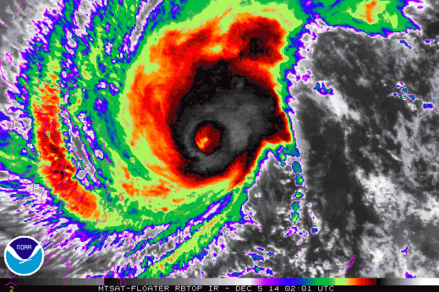
Gigantic eye! This may very well go annular now or hybrid-annular. It is exceedingly rare for a tropical cyclone to execute another ERC (and thus re-strengthen) once it has developed a large eye and started a recurve or stalled out.
0 likes
-
oaba09
- S2K Supporter

- Posts: 1496
- Age: 39
- Joined: Thu Oct 01, 2009 10:02 am
- Location: Valenzuela, Philippines
- Contact:
Re: WPAC: HAGUPIT - Typhoon
Latest prognostic reasoning from JTWC. Most models are in agreement of a Philippines land fall.
WDPN31 PGTW 050300
MSGID/GENADMIN/JOINT TYPHOON WRNCEN PEARL HARBOR HI//
SUBJ/PROGNOSTIC REASONING FOR TYPHOON 22W (HAGUPIT) WARNING NR
17//
RMKS/
1. FOR METEOROLOGISTS.
2. 6 HOUR SUMMARY AND ANALYSIS.
TYPHOON (TY) 22W (HAGUPIT), LOCATED APPROXIMATELY 537 NM EAST-
SOUTHEAST OF MANILA, PHILIPPINES, HAS TRACKED WEST-NORTHWESTWARD AT
07 KNOTS OVER THE PAST SIX HOURS. ANIMATED MULTISPECTRAL SATELLITE
IMAGERY INDICATES A WEAKENING TREND WITH A MORE ASYMMETRIC
CONVECTIVE STRUCTURE AND THE EYE HAS BEEN FILLED IN, LEAVING A
SLIGHT DIMPLE OFFSET TO THE EAST OF THE SYSTEM. A 042301Z GMI AND
042242Z SSMIS IMAGES INDICATE THAT THE BULK OF THE DEEP CONVECTION
IS DISPLACED OVER THE SOUTHWESTERN QUADRANT DUE TO MODERATE (20-25
KNOT) EASTERLY VERTICAL WIND SHEAR (VWS). THERE IS GOOD CONFIDENCE
IN THE CURRENT POSITION AND RECENT TRACK MOTION DUE TO THE DIMPLE
FEATURE AND AFOREMENTIONED MICROWAVE IMAGERY. AS A RESULT OF THE
RECENT WEAKENING TREND, DVORAK INTENSITY ESTIMATES HAVE DECREASED TO
T6.0 WITH CURRENT INTENSITY ESTIMATES AT T7.0, AS SUCH, THE INITIAL
INTENSITY HAS BEEN DECREASED SIGNIFICANTLY TO 125 KNOTS WITH
POTENTIAL FOR FURTHER WEAKENING AS THERE IS INCREASED PRESSURE ON
THE SYSTEM DUE TO THE STRONG SUBTROPICAL RIDGE (STR) TO THE
NORTHEAST AND INCREASED VWS. TY HAGUPIT IS CURRENTLY TRACKING ALONG
THE SOUTHWESTERN PERIPHERY OF THE (STR).
3. FORECAST REASONING.
A. NO CHANGE TO THE FORECAST PHILOSOPHY SINCE THE PREVIOUS
PROGNOSTIC REASONING MESSAGE.
B. TY HAGUPIT WILL MAINTAIN A GENERALLY WEST TO WEST-
NORTHWESTWARD TRAJECTORY UNDER THE STEERING INFLUENCE OF THE STR
THROUGH TAU 48. BETWEEN TAUS 24-48, THE SYSTEM IS EXPECTED TO SLOW
SLIGHTLY AS AN APPROACHING, WEAK SHORTWAVE TROUGH PASSING TO THE
NORTH WILL PRODUCE A WEAKNESS IN THE STEERING RIDGE, ALLOWING THE
SYSTEM TO TRACK SLIGHTLY POLEWARD. BASED ON THE INCREASE IN THE
MODERATE VWS, TY 22W IS FORECAST TO WEAKEN THROUGH TAU 36 AND THEN
CONTINUE TO WEAKEN AS TY HAGUPIT BEGINS LAND INTERACTION AT TAU 48
NORTH OF SAMAR. MODEL GUIDANCE CONTINUES TO COME INTO MUCH BETTER
AGREEMENT WITH THE TRACK OF THE SYSTEM THROUGH TAU 72.
C. IN THE EXTENDED FORECAST, THE BULK OF THE DYNAMIC MODELS HAVE
COME INTO CLOSER AGREEMENT ON A GENERALLY WESTWARD TRACK OVER THE
PHILIPPINES. WHILE THERE IS STILL SOME DISAGREEMENT IN THE EXACT
PLACEMENT OF THE SYSTEM, RANGING BETWEEN THE CAGAYAN VALLEY IN
CENTRAL LUZON TO JUST NORTH OF PANAY, THERE IS BETTER CONFIDENCE IN
THE JTWC FORECAST TRACK, WHICH LAYS CLOSE TO THE MULTI-MODEL
CONSENSUS. AS EXPECTED, THE SYSTEM WILL CONTINUE TO GRADUALLY WEAKEN
DUE TO LAND INTERACTION AS WELL AS INCREASED SHEER. THERE IS THE
POSSIBILITY THAT THE SYSTEM WILL STILL MAINTAIN TYPHOON INTENSITY
UPON REACHING THE SOUTH CHINA SEA BY TAU 120. HOWEVER INCREASED VWS
DUE TO THE NORTH EASTERLY SURGE EVENT MAY PRECLUDE ANY FURTHER
DEVELOPMENT. OVERALL, THERE IS STILL LOW CONFIDENCE IN THE EXTENDED
FORECAST TRACK DUE TO THE WIDE SPREAD OF THE MODELS IN THE
UNCERTAINTY OF THE EXACT TRACK WESTWARD ALTHOUGH THE DYNAMIC MODELS
ARE IN BETTER AGREEMENT.//
NNNN
0 likes
-
euro6208
Re: WPAC: HAGUPIT - Typhoon
ozonepete wrote:Gigantic eye! This may very well go annular now or hybrid-annular. It is exceedingly rare for a tropical cyclone to execute another ERC (and thus re-strengthen) once it has developed a large eye and started a recurve or stalled out.
[url=http://s189.photobucket.com/user/philnyc_2007/media/satrbtop2014-12-050201_zpsb6a409f1.gif.html]
Oh dear. could we be seeing a new monster in the making since this still has 2 whole days before reaching land?
Last edited by euro6208 on Thu Dec 04, 2014 9:41 pm, edited 1 time in total.
0 likes

Re: WPAC: HAGUPIT - Typhoon
ozonepete wrote:Gigantic eye! This may very well go annular now or hybrid-annular. It is exceedingly rare for a tropical cyclone to execute another ERC (and thus re-strengthen) once it has developed a large eye and started a recurve or stalled out.
[img ]http://i189.photobucket.com/albums/z174/philnyc_2007/satrbtop2014-12-050201_zpsb6a409f1.gif[/img]
Will be interesting to see a wind field analysis in about 12 hours or so. Could be some incredible surge if it moves westward.
0 likes
-
ozonepete
- Professional-Met
- Posts: 4743
- Joined: Mon Sep 07, 2009 3:23 pm
- Location: From Ozone Park, NYC / Now in Brooklyn, NY
Re: WPAC: HAGUPIT - Typhoon
RL3AO wrote:ozonepete wrote:Gigantic eye! This may very well go annular now or hybrid-annular. It is exceedingly rare for a tropical cyclone to execute another ERC (and thus re-strengthen) once it has developed a large eye and started a recurve or stalled out.
[img ]http://i189.photobucket.com/albums/z174/philnyc_2007/satrbtop2014-12-050201_zpsb6a409f1.gif[/img]
Will be interesting to see a wind field analysis in about 12 hours or so. Could be some incredible surge if it moves westward.
Surge could be tremendous since weakening cat 5's can get down to a cat 2 but still carry a cat 4 or 5 surge. Very dangerous.
0 likes
-
ozonepete
- Professional-Met
- Posts: 4743
- Joined: Mon Sep 07, 2009 3:23 pm
- Location: From Ozone Park, NYC / Now in Brooklyn, NY
Re: WPAC: HAGUPIT - Typhoon
euro6208 wrote:ozonepete wrote:Gigantic eye! This may very well go annular now or hybrid-annular. It is exceedingly rare for a tropical cyclone to execute another ERC (and thus re-strengthen) once it has developed a large eye and started a recurve or stalled out.
[url=http://s189.photobucket.com/user/philnyc_2007/media/satrbtop2014-12-050201_zpsb6a409f1.gif.html]
Oh dear. could we be seeing a new monster in the making since this still has 2 whole days before reaching land?
No. luckily. The large eye means it can maintain close to current strength more easily but cannot strengthen.
0 likes
Re: WPAC: HAGUPIT - Typhoon
ozonepete wrote:RL3AO wrote:ozonepete wrote:Gigantic eye! This may very well go annular now or hybrid-annular. It is exceedingly rare for a tropical cyclone to execute another ERC (and thus re-strengthen) once it has developed a large eye and started a recurve or stalled out.
[img ]http://i189.photobucket.com/albums/z174/philnyc_2007/satrbtop2014-12-050201_zpsb6a409f1.gif[/img]
Will be interesting to see a wind field analysis in about 12 hours or so. Could be some incredible surge if it moves westward.
Surge could be tremendous since weakening cat 5's can get down to a cat 2 but still carry a cat 4 or 5 surge. Very dangerous.
Yes. Of course there is a big difference between a west moving storm hitting perpendicular to the land and starting to recurve and skirting or hitting at a more acute angle.
0 likes
-
ozonepete
- Professional-Met
- Posts: 4743
- Joined: Mon Sep 07, 2009 3:23 pm
- Location: From Ozone Park, NYC / Now in Brooklyn, NY
Re: WPAC: HAGUPIT - Typhoon
RL3AO wrote:
Yes. Of course there is a big difference between a west moving storm hitting perpendicular to the land and starting to recurve and skirting or hitting at a more acute angle.
Yup. I still think it's going to recurve enough to miss Tacloban and the central Philippines. I've been saying up near Naga and I'm sticking to that for now. That would be good news for Manila because it will cross a lot of land before it gets there and thus weaken considerably.
0 likes
-
dexterlabio
- Category 5

- Posts: 3511
- Joined: Sat Oct 24, 2009 11:50 pm
Re: WPAC: HAGUPIT - Typhoon
ozonepete wrote:Yup. I still think it's going to recurve enough to miss Tacloban and the central Philippines. I've been saying up near Naga and I'm sticking to that for now. That would be good news for Manila because it will cross a lot of land before it gets there and thus weaken considerably.
Nice to see you again here.
0 likes
Personal Forecast Disclaimer:
The posts in this forum are NOT official forecast and should not be used as such. They are just the opinion of the poster and may or may not be backed by sound meteorological data. They are NOT endorsed by any professional institution or storm2k.org. For official information, please refer to the NHC and NWS products.
The posts in this forum are NOT official forecast and should not be used as such. They are just the opinion of the poster and may or may not be backed by sound meteorological data. They are NOT endorsed by any professional institution or storm2k.org. For official information, please refer to the NHC and NWS products.
-
euro6208
Re: WPAC: HAGUPIT - Typhoon
Our local typhoon chaser and storm2k member James Reynolds driving up north from tacloban in his latest twit...
0 likes
-
oaba09
- S2K Supporter
- Posts: 1496
- Age: 39
- Joined: Thu Oct 01, 2009 10:02 am
- Location: Valenzuela, Philippines
- Contact:
Re: WPAC: HAGUPIT - Typhoon
So they are moving the track northward and dropping intensity steadily. That's what I've been expecting. They will likely keep shifting the track to more of a recurve as we go forward.[/quote]
Actually, if you look at JTWC's track history they actually moved their track southwards(they had a more northern track yesterday)...
Actually, if you look at JTWC's track history they actually moved their track southwards(they had a more northern track yesterday)...
0 likes
-
ozonepete
- Professional-Met
- Posts: 4743
- Joined: Mon Sep 07, 2009 3:23 pm
- Location: From Ozone Park, NYC / Now in Brooklyn, NY
Re: WPAC: HAGUPIT - Typhoon
spiral wrote:
With respect ozonepete its just normal for a system to weaken during EWR but after the outer eyewall has replaced the inner one completely a storm may re-intensify.
Lol much respect for you too but I didn't say that after an ERC a TC doesn't re-intensify. They normally do. I said that recurving tropical cyclones or ones that stall just before a recurve rarely ever intensify again. Go read that post again.
0 likes

-
ozonepete
- Professional-Met
- Posts: 4743
- Joined: Mon Sep 07, 2009 3:23 pm
- Location: From Ozone Park, NYC / Now in Brooklyn, NY
Re: WPAC: HAGUPIT - Typhoon
?? But we were talking about the adjustment since the last advisory, not from yesterday til now.oaba09 wrote:ozonepete wrote:
So they are moving the track northward and dropping intensity steadily. That's what I've been expecting. They will likely keep shifting the track to more of a recurve as we go forward.
Actually, if you look at JTWC's track history they actually moved their track southwards(they had a more northern track yesterday)...
0 likes
-
euro6208
Re: WPAC: HAGUPIT - Typhoon
looks like it just completed the eyewall replacement cycle and is strengthening again...
0 likes
-
xtyphooncyclonex

- Category 5
- Posts: 3892
- Age: 24
- Joined: Sat Dec 08, 2012 9:07 am
- Location: Cebu City
- Contact:
Re: WPAC: HAGUPIT - Typhoon
With due respect ozonepete, as dexterlabio has said, a recurve is when a storm moves NE and misses the landmass entirely yet you mentioned that this would hit Bicol/Southern Luzon. 
0 likes
REMINDER: My opinions that I, or any other NON Pro-Met in this forum, are unofficial. Please do not take my opinions as an official forecast and warning. I am NOT a meteorologist. Following my forecasts blindly may lead to false alarm, danger and risk if official forecasts from agencies are ignored.
-
ozonepete
- Professional-Met
- Posts: 4743
- Joined: Mon Sep 07, 2009 3:23 pm
- Location: From Ozone Park, NYC / Now in Brooklyn, NY
Re: WPAC: HAGUPIT - Typhoon
dexterlabio wrote:ozonepete wrote:Yup. I still think it's going to recurve enough to miss Tacloban and the central Philippines. I've been saying up near Naga and I'm sticking to that for now. That would be good news for Manila because it will cross a lot of land before it gets there and thus weaken considerably.
Nice to see you again here.
Haha it's used a little loosely in the business or seems that way. But missing land is not part of the definition of recurve. Any time a TC (in the northern hemisphere) starts to move northward from a westward track it is recurving. Recurving does not mean it will miss land. Some of the most intense and/or noteworthy storms to hit Manila moved west of the central Philippines and then recurved northeastward over you. So when I say that this storm will not continue westward but turn west-northwestward or northwestward it's natural to say it's recurving. It may recurve for a while and then turn back westward but while it is curving poleward from a westward track it is said to be recurving. OK?
0 likes
-
ozonepete
- Professional-Met
- Posts: 4743
- Joined: Mon Sep 07, 2009 3:23 pm
- Location: From Ozone Park, NYC / Now in Brooklyn, NY
Re: WPAC: HAGUPIT - Typhoon
xtyphooncyclonex wrote:With due respect ozonepete, as dexterlabio has said, a recurve is when a storm moves NE and misses the landmass entirely yet you mentioned that this would hit Bicol/Southern Luzon.
No. See my post just above. I explained how we use the terminology in tropical forecasting.
0 likes
-
euro6208
Re: WPAC: HAGUPIT - Typhoon
ozonepete wrote:dexterlabio wrote:ozonepete wrote:Yup. I still think it's going to recurve enough to miss Tacloban and the central Philippines. I've been saying up near Naga and I'm sticking to that for now. That would be good news for Manila because it will cross a lot of land before it gets there and thus weaken considerably.
Nice to see you again here.
Haha it's used a little loosely in the business or seems that way. But missing land is not part of the definition of recurve. Any time a TC (in the northern hemisphere) starts to move northward from a westward track it is recurving. Recurving does not mean it will miss land. Some of the most intense and/or noteworthy storms to hit Manila moved west of the central Philippines and then recurved northeastward over you. So when I say that this storm will not continue westward but turn west-northwestward or northwestward it's natural to say it's recurving. It may recurve for a while and then turn back westward but while it is curving poleward from a westward track it is said to be recurving. OK?
Thanks for this info...I even thought recurve means a north and northeast track
0 likes
-
dexterlabio
- Category 5
- Posts: 3511
- Joined: Sat Oct 24, 2009 11:50 pm
Re: WPAC: HAGUPIT - Typhoon
ozonepete wrote:
Haha it's used a little loosely in the business or seems that way. But missing land is not part of the definition of recurve. Any time a TC (in the northern hemisphere) starts to move northward from a westward track it is recurving. Recurving does not mean it will miss land. Some of the most intense and/or noteworthy storms to hit Manila moved west of the central Philippines and then recurved northeastward over you. So when I say that this storm will not continue westward but turn west-northwestward or northwestward it's natural to say it's recurving. It may recurve for a while and then turn back westward but while it is curving poleward from a westward track it is said to be recurving. OK?
Haha ok got it. Because in the Philippines when PAGASA says "recurve", it means the storm is going towards Japan.
0 likes
Personal Forecast Disclaimer:
The posts in this forum are NOT official forecast and should not be used as such. They are just the opinion of the poster and may or may not be backed by sound meteorological data. They are NOT endorsed by any professional institution or storm2k.org. For official information, please refer to the NHC and NWS products.
The posts in this forum are NOT official forecast and should not be used as such. They are just the opinion of the poster and may or may not be backed by sound meteorological data. They are NOT endorsed by any professional institution or storm2k.org. For official information, please refer to the NHC and NWS products.
Who is online
Users browsing this forum: No registered users and 6 guests