Texas Winter 2014-2015
Moderator: S2k Moderators
Forum rules
 The posts in this forum are NOT official forecast and should not be used as such. They are just the opinion of the poster and may or may not be backed by sound meteorological data. They are NOT endorsed by any professional institution or STORM2K.

The posts in this forum are NOT official forecast and should not be used as such. They are just the opinion of the poster and may or may not be backed by sound meteorological data. They are NOT endorsed by any professional institution or STORM2K.
-
Ralph's Weather
- S2K Supporter

- Posts: 3374
- Age: 38
- Joined: Fri Dec 13, 2013 11:55 am
- Location: Lindale, TX
- Contact:
Looks like the freeze line is along I-35W right now. Not seeing any reports of precip in the cold air across North Texas so we should be clear of any freezing drizzle though it cannot be completely ruled out. Enjoy the cold air to start the month as it looks like we will get mild and wet for the next couple weeks though the cold air could decide to break through again at some point. The latter half of the month is looking fun so cannot wait for that.
0 likes
Follow on Facebook at Ralph's Weather.
-
TeamPlayersBlue

- Category 5

- Posts: 3533
- Joined: Tue Feb 02, 2010 1:44 am
- Location: Denver/Applewood, CO
December will be very interesting once the MJO swings around into a more favorable position for cooler weather too. Happy December 1 folks!
0 likes
Personal Forecast Disclaimer:
The posts in this forum are NOT official forecast and should not be used as such. They are just the opinion of the poster and may or may not be backed by sound meteorological data. They are NOT endorsed by any professional institution or storm2k.org. For official information, please refer to the NHC and NWS products.
The posts in this forum are NOT official forecast and should not be used as such. They are just the opinion of the poster and may or may not be backed by sound meteorological data. They are NOT endorsed by any professional institution or storm2k.org. For official information, please refer to the NHC and NWS products.
-
Tireman4

- S2K Supporter
- Posts: 5904
- Age: 60
- Joined: Fri Jun 30, 2006 1:08 pm
- Location: Humble, Texas
- Contact:
Re:
TeamPlayersBlue wrote:December will be very interesting once the MJO swings around into a more favorable position for cooler weather too. Happy December 1 folks!
Yep. You warm mongerers....enjoy it while it lasts. The Cold air is coming. The deep freeze is coming. Thank you. That is all.
0 likes

Hoping to see some snow in NTX during the last 2 weeks of December. 
0 likes
The following post is NOT an official forecast and should not be used as such. It is just the opinion of the poster and may or may not be backed by sound meteorological data. It is NOT endorsed by any professional institution including storm2k.org For Official Information please refer to the NHC and NWS products.
-
Ralph's Weather
- S2K Supporter
- Posts: 3374
- Age: 38
- Joined: Fri Dec 13, 2013 11:55 am
- Location: Lindale, TX
- Contact:
Re:
KatDaddy wrote:Hoping to see some snow in NTX during the last 2 weeks of December.
The chance for that is definitely above average.
0 likes
Follow on Facebook at Ralph's Weather.
-
CaptinCrunch

- S2K Supporter
- Posts: 8784
- Age: 58
- Joined: Mon Nov 03, 2003 4:33 pm
- Location: Kennedale, TX (Tarrant Co.)
Re: Texas Winter 2014-2015
Now that we have closed out November, let's see how it looked for North Texas area.
The average high was 62.2 degrees, the average low was 40.7
Monthly avg. was 51.5 degrees
DPTR from Normal: -5.1
Highest: 79 on 10th & 30th
Lowest: 22 on 18th
Number of official Freezes at DFW Airport: 6
Precipitation for the month: 2.13 inches
DPTR from normal: -0.58
SNOW: Trace on the 16th
Making November 2014 the 6th coldest November on record by .1 degrees. Last time November was this cold was 1993 with an avg. of 51.6 degrees.
0 likes
-
Texas Snowman

- Storm2k Moderator

- Posts: 6197
- Joined: Fri Jan 25, 2008 11:29 am
- Location: Denison, Texas
39 and breezy in Denison. Perfect weather to start off Winter 2014-15. Going to burn some wood tonight!
0 likes
The above post and any post by Texas Snowman is NOT an official forecast and should not be used as such. It is just the opinion of the poster and may or may not be backed by sound meteorological data. It is NOT endorsed by any professional institution including storm2k.org. For official information, please refer to NWS products.
-
srainhoutx

- S2K Supporter
- Posts: 6919
- Age: 68
- Joined: Sun Jan 14, 2007 11:34 am
- Location: Haywood County, NC
- Contact:
Re: Texas Winter 2014-2015
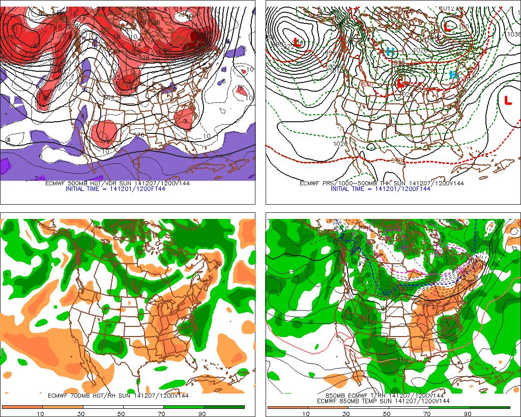
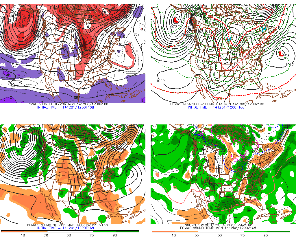
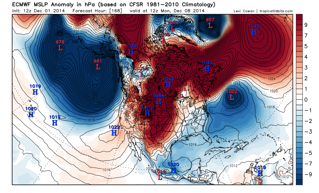
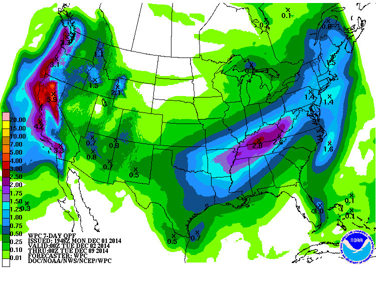
The guidance is trending toward a solution that may bring a Southern tracking storm across Northern Mexico into the Southern Rockies and the Southern Plains this coming weekend. The Euro is a bit stronger with the shortwave and the upper air disturbance and suggests some cooler air will push S across the Plains in the wake of the storm system. The Weather Prediction Center is increasing rainfall potential, so it will likely be our next weather maker after we warm up a bit this week and a return flow off the Gulf becomes established after todays cold front retreats back N on Tuesday night into Wednesday. This sort of pattern is very El Nino like, so it is possible we will see similar tracking storm systems as we head deeper into Winter. It is also noteworthy that the West Coast will benefit from such a pattern and will go along way to helping in the multi year drought that has plagued California.
0 likes
Carla/Alicia/Jerry(In The Eye)/Michelle/Charley/Ivan/Dennis/Katrina/Rita/Wilma/Ike/Harvey
Member: National Weather Association
Wx Infinity Forums
http://wxinfinity.com/index.php
Facebook.com/WeatherInfinity
Twitter @WeatherInfinity
Member: National Weather Association
Wx Infinity Forums
http://wxinfinity.com/index.php
Facebook.com/WeatherInfinity
Twitter @WeatherInfinity
-
somethingfunny

- ChatStaff

- Posts: 3926
- Age: 37
- Joined: Thu May 31, 2007 10:30 pm
- Location: McKinney, Texas
Re: Texas Winter 2014-2015
So much for having a drizzly overcast dreary 35 degree day, it's currently about 40 degrees and sunny here in Garland. With clear skies I'd expect we will cool off below freezing tonight, although FWD just wrote what might be the longest discussion of low clouds I've ever seen:
THE LOW CLOUD BANK IS THE COMPLICATING FACTOR IN THE FORECAST
TONIGHT AND SINCE MOST MODEL GUIDANCE DOES NOT REALLY HAVE THE
RESOLUTION TO HANDLE THE MOISTURE TRAPPED AT THE FRONTAL INVERSION
MODELS ARE NOT TRUSTWORTHY TONIGHT. ESSENTIALLY THERE IS HIGH
CONFIDENCE THAT THE SOUTHERN HALF OF THE CWA WILL STAY CLOUDY.
THIS MEANS TEMPERATURES WILL STAY ABOVE FREEZING IF NOT IN THE MID
TO UPPER 30S DUE TO WANING COLD ADVECTION AND THE WARMING EFFECTS
OF LOW CLOUD COVER. HOWEVER IN THE CLEAR AREAS...WINDS WILL BECOME
NEARLY CALM BY SUNRISE AND THE AIR IS VERY DRY WHICH WILL ALLOW
TEMPS TO DROP INTO THE LOW 20S...IF NOT THE UPPER TEENS. THE
NORTHERN 2 ROWS OF COUNTIES HAVE THE HIGHEST CHANCE OF BEING CLEAR
TONIGHT...BUT LATEST SATELLITE SHOWS LOW CLOUDS FROM GRAHAM TO
ABILENE AND ACROSS OKLAHOMA THAT ARE NOT SHOWN BY VIRTUALLY ALL
GUIDANCE. THESE CLOUDS ARE SUPPOSED TO DISSIPATE DUE TO CONTINUED
ISENTROPIC DOWNGLIDE...BUT USUALLY THEY ARE MORE STUBBORN THAN
EXPECTED. THUS THE FORECAST LOWS MAY END UP BEING TOO COOL OVER
NORTHERN ZONES. OTHERWISE THE EDGE OF THE CLOUD BANK IS LIKELY TO
BISECT THE METROPLEX THIS EVENING...BUT ANY SUBTLE WAVERING OF THE
LOW LEVEL WINDS MAY BRING THE CLEARING LINE MORE NORTH OR SOUTH
THUS AFFECTING LOW TEMPS GREATLY.
0 likes
I am not a meteorologist, and any posts made by me are not official forecasts or to be interpreted as being intelligent. These posts are just my opinions and are probably silly opinions.
-
aggiecutter
- Category 5
- Posts: 1755
- Joined: Thu Oct 14, 2004 9:22 pm
- Location: Texarkana

-
Texas Snowman
- Storm2k Moderator
- Posts: 6197
- Joined: Fri Jan 25, 2008 11:29 am
- Location: Denison, Texas
I think I saw a map like that a few weeks ago.
In October.
Before one of the coldest Novembers in North Texas history.
Maybe it will happen. Or maybe it won't. Guess we shall see if Portastorm and Ntxw get to control the weather this month or weather Wxman 57 has found the magic weather machine again.
In October.
Before one of the coldest Novembers in North Texas history.
Maybe it will happen. Or maybe it won't. Guess we shall see if Portastorm and Ntxw get to control the weather this month or weather Wxman 57 has found the magic weather machine again.
0 likes
The above post and any post by Texas Snowman is NOT an official forecast and should not be used as such. It is just the opinion of the poster and may or may not be backed by sound meteorological data. It is NOT endorsed by any professional institution including storm2k.org. For official information, please refer to NWS products.
-
Texas Snowman
- Storm2k Moderator
- Posts: 6197
- Joined: Fri Jan 25, 2008 11:29 am
- Location: Denison, Texas
@BigJoeBastardi: MASSIVE disagreement Euro package with US models. Control colder than normal plains east next 15 days. Ensemble not as warm as GFS either
0 likes
The above post and any post by Texas Snowman is NOT an official forecast and should not be used as such. It is just the opinion of the poster and may or may not be backed by sound meteorological data. It is NOT endorsed by any professional institution including storm2k.org. For official information, please refer to NWS products.

Re:
Texas Snowman wrote:@BigJoeBastardi: MASSIVE disagreement Euro package with US models. Control colder than normal plains east next 15 days. Ensemble not as warm as GFS either
I think the guidance is struggling from the strong MJO signal. +PNA will rule the roost, the areas most likely at risk for above normal is the northern plains. But if that block is centered more into Canada and shifts to around Hudson bay and the STJ makes noise it's a very different pattern for just subtle differences. The areas least at risk from above normal temperatures would be the southern plains and southeast #ElNino. A good example would be this arctic front, models around Thanksgiving had warmth because they saw ridging aloft but not until recently did they see the cold air bleed anyway. GFS had us in the 60s to near 70s for today and tomorrow and that busted, no contest.
0 likes
The above post and any post by Ntxw is NOT an official forecast and should not be used as such. It is just the opinion of the poster and may or may not be backed by sound meteorological data. It is NOT endorsed by any professional institution including Storm2k. For official information, please refer to NWS products.
Help support Storm2K!
-
orangeblood
- S2K Supporter
- Posts: 3895
- Joined: Tue Dec 15, 2009 6:14 pm
- Location: Fort Worth, TX
Re: Texas Winter 2014-2015
Latest Euro Weeklies are going blow torch across Canada into the Arctic with a Negative AO showing up....although probably no Arctic Outbreaks in the foreseeable future, it definitely looks below normal and stormy. Will it get cold enough for frozen precip is obviously the question on most everyone's minds ? Unfortunately that might be very difficult given the snow cover across the northern plains into Canada is going to be eroded away over the next few weeks. Not the start to the meteorological winter I was hoping for!!!
0 likes
-
cycloneye

- Admin

- Posts: 149730
- Age: 69
- Joined: Thu Oct 10, 2002 10:54 am
- Location: San Juan, Puerto Rico
Re: Texas Winter 2014-2015
It looks like things are changing in regard to the track of HAGUPIT that the agencies don't show the recurve scenario after the Typhoon turns extratropical so it appears no NURI repeat in terms of the teleconnections.
0 likes
Visit the Caribbean-Central America Weather Thread where you can find at first post web cams,radars
and observations from Caribbean basin members Click Here
and observations from Caribbean basin members Click Here
7th freeze for DFW just occured as of 9pm. FW is calling for low 20s, should be 8th freeze in a few hours.
0 likes
The above post and any post by Ntxw is NOT an official forecast and should not be used as such. It is just the opinion of the poster and may or may not be backed by sound meteorological data. It is NOT endorsed by any professional institution including Storm2k. For official information, please refer to NWS products.
Help support Storm2K!
Help support Storm2K!
-
Nairobi
Re: Texas Winter 2014-2015
The GFS hardly gets Austin down to 50 for lows through Dec. 17th.
You can dream I suppose, doubtful it will stay that way.
0 likes
Who is online
Users browsing this forum: No registered users and 62 guests