HURRICANE GONZALO TROPICAL CYCLONE UPDATE
NWS NATIONAL HURRICANE CENTER MIAMI FL AL082014
400 PM AST WED OCT 17 2014
...400 PM POSITION UPDATE...
...DANGEROUS HURRICANE GONZALO APPROACHING BERMUDA...
SUMMARY OF 400 PM AST...2000 UTC...INFORMATION
--------------------------------------------------
LOCATION...31.4N 65.5W
ABOUT 75 MI...120 KM SSW OF BERMUDA
MAXIMUM SUSTAINED WINDS...115 MPH...185 KM/H
PRESENT MOVEMENT...NNE OR 025 DEGREES AT 16 MPH...26 KM/H
MINIMUM CENTRAL PRESSURE...951 MB...28.08 INCHES
$$
FORECASTER AVILA
ATL: GONZALO - Post-Tropical - Discussion
Moderator: S2k Moderators
-
cycloneye

- Admin

- Posts: 149550
- Age: 69
- Joined: Thu Oct 10, 2002 10:54 am
- Location: San Juan, Puerto Rico
Re: ATL: GONZALO - Hurricane - Discussion
0 likes
Visit the Caribbean-Central America Weather Thread where you can find at first post web cams,radars
and observations from Caribbean basin members Click Here
and observations from Caribbean basin members Click Here

Re:
panamatropicwatch wrote:Latest radar image which has the whole eye.

Wondering if that NW quadrant of the eye is truly attempting to wrap that convection into and around itself, and into a smaller tighter eye. At least to me, looking on satellite, the eye seems to appear tighter than the radar display is indicating. Im assuming that has more to do with the declination or angle of the radar view?
0 likes
Andy D
(For official information, please refer to the NHC and NWS products.)
(For official information, please refer to the NHC and NWS products.)
Re: Re:
chaser1 wrote:
Wondering if that NW quadrant of the eye is truly attempting to wrap that convection into and around itself, and into a smaller tighter eye. At least to me, looking on satellite, the eye seems to appear tighter than the radar display is indicating. Im assuming that has more to do with the declination or angle of the radar view?
My guess would be reverse stadium effect from top to bottom.
0 likes
-
EquusStorm
- Category 5

- Posts: 1649
- Age: 35
- Joined: Thu Nov 07, 2013 1:04 pm
- Location: Jasper, AL
- Contact:
Re: ATL: GONZALO - Hurricane - Discussion
cycloneye wrote:HURRICANE GONZALO TROPICAL CYCLONE UPDATE
NWS NATIONAL HURRICANE CENTER MIAMI FL AL082014
400 PM AST WED OCT 17 2014
...400 PM POSITION UPDATE...
...DANGEROUS HURRICANE GONZALO APPROACHING BERMUDA...
SUMMARY OF 400 PM AST...2000 UTC...INFORMATION
--------------------------------------------------
LOCATION...31.4N 65.5W
ABOUT 75 MI...120 KM SSW OF BERMUDA
MAXIMUM SUSTAINED WINDS...115 MPH...185 KM/H
PRESENT MOVEMENT...NNE OR 025 DEGREES AT 16 MPH...26 KM/H
MINIMUM CENTRAL PRESSURE...951 MB...28.08 INCHES
$$
FORECASTER AVILA
Well, looks like it's not going to be quite as intense as Fabian then. Might tie in the wind speed though. Either way, the worst isn't that far from the island...
0 likes
Colors of lost purpose on the canvas of irrelevance
Not a meteorologist, in fact more of an idiot than anything. You should probably check with the NHC or a local NWS office for official information.
Not a meteorologist, in fact more of an idiot than anything. You should probably check with the NHC or a local NWS office for official information.
-
brunota2003

- S2K Supporter

- Posts: 9476
- Age: 35
- Joined: Sat Jul 30, 2005 9:56 pm
- Location: Stanton, KY...formerly Havelock, NC
- Contact:

Re: ATL: GONZALO - Hurricane - Discussion
Looks like the storm surge will be coming right into that port with the wind blowing on that camera shot.
http://portbermudawebcam.com/
http://portbermudawebcam.com/
0 likes
Re:
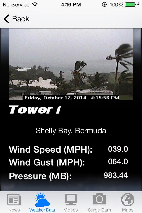
brunota2003 wrote:Mark's anemometer is recording sustained winds of 40 mph with gusts to 65 mph. Not quite certain where on the island it is located.
Seems he must be using a hand held, and just not safely able to get the exposure (or height) to get a better reading
0 likes
Andy D
(For official information, please refer to the NHC and NWS products.)
(For official information, please refer to the NHC and NWS products.)
Re: ATL: GONZALO - Hurricane - Discussion
ronjon wrote:Looks like the storm surge will be coming right into that port with the wind blowing on that camera shot.
http://portbermudawebcam.com/
Yeah, i keep stepping away , then returning to look at the cam.... and for a few clips, noticed some ocean spray fully envelope the tops of those palms that are farthest out on that dock
0 likes
Andy D
(For official information, please refer to the NHC and NWS products.)
(For official information, please refer to the NHC and NWS products.)
-
brunota2003
- S2K Supporter
- Posts: 9476
- Age: 35
- Joined: Sat Jul 30, 2005 9:56 pm
- Location: Stanton, KY...formerly Havelock, NC
- Contact:
Re: Re:
chaser1 wrote:brunota2003 wrote:Mark's anemometer is recording sustained winds of 40 mph with gusts to 65 mph. Not quite certain where on the island it is located.
Seems he must be using a hand held, and just not safely able to get the exposure (or height) to get a better reading
No, this is from his tower set up near a contractor's house. The wind reading is from an RM Young anemometer...not sure about it's exposure, but the webcam image on his app looked pretty exposed (at least in the one direction).
0 likes
Just a small town southern boy helping other humans.
Re: ATL: GONZALO - Hurricane - Discussion
hmmmmmm, looking at the "funktop" imagery satellite, it appears to me that the island is now just within the core of the storm.
0 likes
Andy D
(For official information, please refer to the NHC and NWS products.)
(For official information, please refer to the NHC and NWS products.)
-
floridasun78
- Category 5
- Posts: 3755
- Joined: Sun May 17, 2009 10:16 pm
- Location: miami fl
-
brunota2003
- S2K Supporter
- Posts: 9476
- Age: 35
- Joined: Sat Jul 30, 2005 9:56 pm
- Location: Stanton, KY...formerly Havelock, NC
- Contact:
Re: ATL: GONZALO - Hurricane - Discussion
Here's an image of the app earlier:
0 likes
Just a small town southern boy helping other humans.
-
ScottNAtlanta

- Category 5
- Posts: 2535
- Joined: Sat May 25, 2013 3:11 pm
- Location: Atlanta, GA
8552 viewers on the port webcam currently
0 likes
The posts in this forum are NOT official forecast and should not be used as such. They are just the opinion of the poster and may or may not be backed by sound meteorological data. They are NOT endorsed by any professional institution or storm2k.org. For official information, please refer to the NHC and NWS products.
Re: ATL: GONZALO - Hurricane - Discussion
brunota2003 wrote:Here's an image of the app earlier:
Your right, doesnt seem to be any obvious obstruction but then again hard to see enough of a panoramic view to tell
0 likes
Andy D
(For official information, please refer to the NHC and NWS products.)
(For official information, please refer to the NHC and NWS products.)
Re:
ScottNAtlanta wrote:8552 viewers on the port webcam currently
I'd guess 1/3 of them are those hunkered down on the island, wanting a peek to see whats going on outside. Wonder how many are from S2K watching presently?? The board is pretty quite, so assume many are on and just watching.
0 likes
Andy D
(For official information, please refer to the NHC and NWS products.)
(For official information, please refer to the NHC and NWS products.)
-
ScottNAtlanta
- Category 5
- Posts: 2535
- Joined: Sat May 25, 2013 3:11 pm
- Location: Atlanta, GA
Looks like the water has submerged the wall now. This is the worst whiteout yet...I see nothing through the rain
Last edited by ScottNAtlanta on Fri Oct 17, 2014 3:51 pm, edited 1 time in total.
0 likes
The posts in this forum are NOT official forecast and should not be used as such. They are just the opinion of the poster and may or may not be backed by sound meteorological data. They are NOT endorsed by any professional institution or storm2k.org. For official information, please refer to the NHC and NWS products.
-
CrazyC83
- Professional-Met

- Posts: 34315
- Joined: Tue Mar 07, 2006 11:57 pm
- Location: Deep South, for the first time!
Re: ATL: GONZALO - Hurricane - Discussion
EquusStorm wrote:cycloneye wrote:HURRICANE GONZALO TROPICAL CYCLONE UPDATE
NWS NATIONAL HURRICANE CENTER MIAMI FL AL082014
400 PM AST WED OCT 17 2014
...400 PM POSITION UPDATE...
...DANGEROUS HURRICANE GONZALO APPROACHING BERMUDA...
SUMMARY OF 400 PM AST...2000 UTC...INFORMATION
--------------------------------------------------
LOCATION...31.4N 65.5W
ABOUT 75 MI...120 KM SSW OF BERMUDA
MAXIMUM SUSTAINED WINDS...115 MPH...185 KM/H
PRESENT MOVEMENT...NNE OR 025 DEGREES AT 16 MPH...26 KM/H
MINIMUM CENTRAL PRESSURE...951 MB...28.08 INCHES
$$
FORECASTER AVILA
Well, looks like it's not going to be quite as intense as Fabian then. Might tie in the wind speed though. Either way, the worst isn't that far from the island...
Also interesting they are doing position estimates for non-US storms, never seen that before when not on a NWS radar.
0 likes
Who is online
Users browsing this forum: No registered users and 12 guests