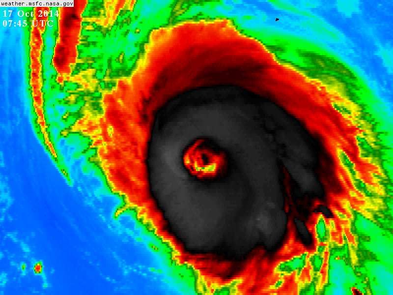
ozonepete wrote:Wow just look at the satellite loops. It's clearly starting another Eye-wall Replacement. This TC just loves ERCs.
that new band is too far out to do anything until after this clears Bermuda
Moderator: S2k Moderators
ozonepete wrote:Wow just look at the satellite loops. It's clearly starting another Eye-wall Replacement. This TC just loves ERCs.

Alyono wrote:ozonepete wrote:Wow just look at the satellite loops. It's clearly starting another Eye-wall Replacement. This TC just loves ERCs.
that new band is too far out to do anything until after this clears Bermuda
TheStormExpert wrote:ozonepete wrote:Wow just look at the satellite loops. It's clearly starting another Eye-wall Replacement. This TC just loves ERCs.
Why do these Eyewall Replacement Cycles keep occurring? This like the third or fourth one.


ozonepete wrote:TheStormExpert wrote:I realize I have mentioned this probably before, but out of curiosity does anyone know if The Weather Channel sent anyone to cover Gonzalo in Bermuda?
I haven't heard anything yet but I would bet my credentials that Cantore will be there unless he has some dire emergency. He always goes to the big ones. Always.


That's my thinking as well. In fact I've felt this way about the track for the past couple of days but time will tell.bahamaswx wrote:Gonna pass to the right of Bermuda at this rate.


NDG wrote:Chasers that have flown into Bermuda to experience Gonzalo are going to be very lucky, looks like Gonzalo's eye will pass over right over the tiny Island, wow how unlucky can Bermuda be!!!
Its rain bands are about 3 hours from reaching the Island, landfall looks to be early afternoon, good for video recording the storm.

Users browsing this forum: No registered users and 14 guests


