ATL: GONZALO - Post-Tropical - Discussion
Moderator: S2k Moderators
-
ozonepete
- Professional-Met

- Posts: 4743
- Joined: Mon Sep 07, 2009 3:23 pm
- Location: From Ozone Park, NYC / Now in Brooklyn, NY
Re: ATL: GONZALO - Hurricane - Discussion
msbee wrote:ozonepete wrote:Looks like St. Martin weather station (TNCM) went down. No new reports since 2300 UTC (7PM EDT). Looks like that island took a beating.
Yes we did! it's been really bad!
Really sorry to hear that. Be careful going outside until the winds die down and remember a lot of things like signs and trees are weakened so they can fall down really easily even in a light wind. Stay safe!
Last edited by ozonepete on Mon Oct 13, 2014 9:19 pm, edited 1 time in total.
0 likes
-
blazess556
- Professional-Met

- Posts: 250
- Joined: Mon Aug 31, 2009 10:51 pm
- Location: Germantown, MD
Re: ATL: GONZALO - Hurricane - Discussion
0.5° Base velocity scan from TJUA at 10:09 p.m. indicated 98.1 kt winds.
Last edited by blazess556 on Mon Oct 13, 2014 9:22 pm, edited 1 time in total.
0 likes
-
ozonepete
- Professional-Met

- Posts: 4743
- Joined: Mon Sep 07, 2009 3:23 pm
- Location: From Ozone Park, NYC / Now in Brooklyn, NY
Re: ATL: GONZALO - Hurricane - Discussion
blazess556 wrote:0.5 Base reflectivity scan from TJUA at 10:09 p.m. indicated at 98.1 kts winds.
Base reflectivity doesn't show winds. You mean velocity radar such as storm relative velocity? And where did it show that?
0 likes
-
ozonepete
- Professional-Met

- Posts: 4743
- Joined: Mon Sep 07, 2009 3:23 pm
- Location: From Ozone Park, NYC / Now in Brooklyn, NY
Re: ATL: GONZALO - Hurricane - Discussion
blazess556 wrote:0.5° Base velocity scan from TJUA at 10:09 p.m. indicated 98.1 kt winds.
Ok.
0 likes
- TheAustinMan
- Category 5

- Posts: 1060
- Joined: Mon Jul 08, 2013 4:26 pm
- Location: Central TX / United States
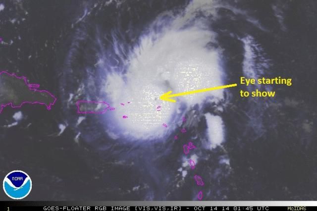
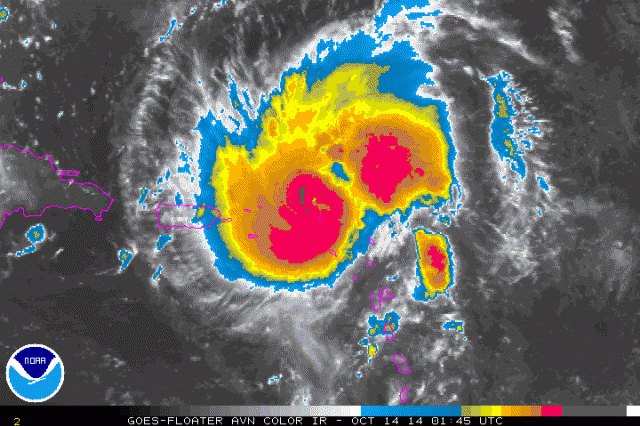
Eye is now fully in view of the long-range radar in San Juan, Puerto Rico, and given the motion of Gonzalo, will likely be viewable from here for the remainder of the night.


0 likes
Treat my opinions with a grain of salt. For official information see your local weather service.
“It's tough to make predictions, especially about the future.”
“It's tough to make predictions, especially about the future.”
Winds up to 85 mph and forecast to 120 mph on latest advisory.
Where do you get the level ii imagery?
Where do you get the level ii imagery?
Last edited by Hammy on Mon Oct 13, 2014 9:41 pm, edited 1 time in total.
0 likes
The above post is not official and should not be used as such. It is the opinion of the poster and may or may not be backed by sound meteorological data. It is not endorsed by any professional institution or storm2k.org. For official information, please refer to the NHC and NWS products.
-
supercane4867
- Category 5

- Posts: 4966
- Joined: Wed Nov 14, 2012 10:43 am
Re: ATL: GONZALO - Hurricane - Discussion
0226z TJUA 0.5° Base reflectivity

0227z TJUA 0.5° Base velocity


0227z TJUA 0.5° Base velocity

0 likes
-
blazess556
- Professional-Met

- Posts: 250
- Joined: Mon Aug 31, 2009 10:51 pm
- Location: Germantown, MD
Re: ATL: GONZALO - Hurricane - Discussion
ozonepete wrote:blazess556 wrote:0.5° Base velocity scan from TJUA at 10:09 p.m. indicated 98.1 kt winds.
Ok.
i was trying to post an image. Its from GRLevel3 in the northwest eyewall.

Last edited by blazess556 on Mon Oct 13, 2014 9:41 pm, edited 1 time in total.
0 likes
- cycloneye
- Admin

- Posts: 149562
- Age: 69
- Joined: Thu Oct 10, 2002 10:54 am
- Location: San Juan, Puerto Rico
Re: ATL: GONZALO - Hurricane - Discussion
BULLETIN
HURRICANE GONZALO ADVISORY NUMBER 7
NWS NATIONAL HURRICANE CENTER MIAMI FL AL082014
1100 PM AST MON OCT 13 2014
...GONZALO CONTINUES TO STRENGTHEN...
...EXPECTED TO PASS NORTHEAST OF THE VIRGIN ISLANDS OVERNIGHT...
SUMMARY OF 1100 PM AST...0300 UTC...INFORMATION
-----------------------------------------------
LOCATION...18.7N 63.4W
ABOUT 40 MI...65 KM NNW OF ANGUILLA
ABOUT 105 MI...170 KM E OF ST. THOMAS
MAXIMUM SUSTAINED WINDS...85 MPH...140 KM/H
PRESENT MOVEMENT...NW OR 315 DEGREES AT 12 MPH...19 KM/H
MINIMUM CENTRAL PRESSURE...984 MB...29.06 INCHES
0 likes
Visit the Caribbean-Central America Weather Thread where you can find at first post web cams,radars
and observations from Caribbean basin members Click Here
and observations from Caribbean basin members Click Here
-
supercane4867
- Category 5

- Posts: 4966
- Joined: Wed Nov 14, 2012 10:43 am
Re: ATL: GONZALO - Hurricane - Discussion
These intense velocities are well-elevated. Radar was scanning at 22500+ft AGL
0 likes
-
blazess556
- Professional-Met

- Posts: 250
- Joined: Mon Aug 31, 2009 10:51 pm
- Location: Germantown, MD
Re: ATL: GONZALO - Hurricane - Discussion
supercane4867 wrote:These intense velocities are well-elevated. Radar was scanning at 22500+ft AGL
yep. btw, how do you change the color tables? my scale only goes to 70 kts.
0 likes
Re: ATL: GONZALO - Hurricane - Discussion
ozonepete wrote:msbee wrote:ozonepete wrote:Looks like St. Martin weather station (TNCM) went down. No new reports since 2300 UTC (7PM EDT). Looks like that island took a beating.
Yes we did! it's been really bad!
Really sorry to hear that. Be careful going outside until the winds die down and remember a lot of things like signs and trees are weakened so they can fall down really easily even in a light wind. Stay safe!
Thanks.
0 likes
Too many hurricanes to remember
-
supercane4867
- Category 5

- Posts: 4966
- Joined: Wed Nov 14, 2012 10:43 am
Re: ATL: GONZALO - Hurricane - Discussion
blazess556 wrote:supercane4867 wrote:These intense velocities are well-elevated. Radar was scanning at 22500+ft AGL
yep. btw, how do you change the color tables? my scale only goes to 70 kts.
You can do that by editing the PAL files under the GR3 folder and select the edited version in Color Table Settings
This is the one I'm using
units: KTS
step: 10
RF: 128 0 208
ND: 0 0 0
color: 160 255 255 255
color: 120 255 255 0
color: 70 255 100 0
color: 40 255 0 0
color: 10.5 112 0 0
color: 0 144 128 144
color: -1 112 128 112
color: -10.5 16 96 16
color: -40 0 255 0
color: -49.5 160 255 208
solidcolor: -50.5 160 255 208
solidcolor: -60 0 255 224
color: -70 0 224 255
color: -90.5 0 0 160
color: -160 0 0 0
0 likes
- tropicwatch
- Category 5

- Posts: 3426
- Age: 62
- Joined: Sat Jun 02, 2007 10:01 am
- Location: The Villages, Florida
- Contact:
He is rockin and rollin.


0 likes
Tropicwatch
Agnes 72', Eloise 75, Elena 85', Kate 85', Charley 86', Florence 88', Beryl 94', Dean 95', Erin 95', Opal 95', Earl 98', Georges 98', Ivan 2004', Arlene 2005', Dennis 2005', Ida 2009' Debby 2012' Irma 2017' Michael 2018'
Agnes 72', Eloise 75, Elena 85', Kate 85', Charley 86', Florence 88', Beryl 94', Dean 95', Erin 95', Opal 95', Earl 98', Georges 98', Ivan 2004', Arlene 2005', Dennis 2005', Ida 2009' Debby 2012' Irma 2017' Michael 2018'
- tropicwatch
- Category 5

- Posts: 3426
- Age: 62
- Joined: Sat Jun 02, 2007 10:01 am
- Location: The Villages, Florida
- Contact:
A little off topic but eventually it will effect Gonzalo. I don't know if I can recall a frontal system being so straight up and down (south to north).


0 likes
Tropicwatch
Agnes 72', Eloise 75, Elena 85', Kate 85', Charley 86', Florence 88', Beryl 94', Dean 95', Erin 95', Opal 95', Earl 98', Georges 98', Ivan 2004', Arlene 2005', Dennis 2005', Ida 2009' Debby 2012' Irma 2017' Michael 2018'
Agnes 72', Eloise 75, Elena 85', Kate 85', Charley 86', Florence 88', Beryl 94', Dean 95', Erin 95', Opal 95', Earl 98', Georges 98', Ivan 2004', Arlene 2005', Dennis 2005', Ida 2009' Debby 2012' Irma 2017' Michael 2018'
-
ozonepete
- Professional-Met

- Posts: 4743
- Joined: Mon Sep 07, 2009 3:23 pm
- Location: From Ozone Park, NYC / Now in Brooklyn, NY
Re:
panamatropicwatch wrote:A little off topic but eventually it will effect Gonzalo. I don't know if I can recall a frontal system being so straight up and down (south to north).
Not off topic at all.
0 likes
- TropicalAnalystwx13
- Category 5

- Posts: 2109
- Age: 28
- Joined: Tue Jul 19, 2011 8:20 pm
- Location: Wilmington, NC
- Contact:
Who is online
Users browsing this forum: No registered users and 13 guests


