ATL: GONZALO - Post-Tropical - Discussion

Moderator: S2k Moderators

Message
Author
Incoming!
Tropical Low
Tropical Low
Posts: 16
Joined: Wed Aug 01, 2012 6:23 pm
Location: Living in the shooting gallery, St Croix USVI

Re: Re:

#481 Postby Incoming! » Mon Oct 13, 2014 6:02 pm

ozonepete wrote:
Incoming! wrote:Dead calm on St Croix - no wind - no rain


It's coming. The first significant band of rain/wind is only about 1-2 hours away from you.


Thanks for the heads up, ozonepete!
0 likes   

adam0983

Re: Re:

#482 Postby adam0983 » Mon Oct 13, 2014 6:07 pm

Getting worse at simpson bay I think we missed the eye.
0 likes   

User avatar
Gustywind
Category 5
Category 5
Posts: 12334
Joined: Mon Sep 03, 2007 7:29 am
Location: Baie-Mahault, GUADELOUPE

#483 Postby Gustywind » Mon Oct 13, 2014 6:10 pm

Here is the latest weather forecast from Meteo-France Guadeloupe concerning the Northern Leewards Islands. I have made the translation french to english. Keeping our fingers crossed. Be safe all my friends Msbee, adam0983...


Regards

Gustywind

:rarrow: http://www.meteofrance.gp/integration/s ... s_nord.pdf (french version)


Bulletin of monitoring VIGILANCE No. 6

for the Northern Islands: Saint-Martin and Saint-Barthélemy


Monday, October 13, 2014 at 17 h 51 legal 21:51 UTC

Episode No. 10 - IN


Level of vigilance: PURPLE

Danger: HURRICANE

Validity:

Start of event: current

Estimated end: Tuesday 13/10/14 at 6AM


Current situation:

Category 1 GONZALO Hurricane

Estimated 13-10 position-2014 at 21 UTC: 17.9 N 62.9 W - Distance from Saint - Martin at the center of

the phenomenon: 27 km - Saint-Barthélemy: 11 km

Mouvement: Northwest 305 degrees to 7 km/h - pressure at the centre: 984 hPa

Winds max on 1 min: 65 knots gusting wind max: 80 knots


Forecasts:

"Gonzalo" comes to the stage of hurricane of category 1, and its center is located at 5 p.m.

on Saint Barthélemy, who suffered for the moment the strongest winds. On this island, the

winds will soon turn West then South sector. It will continue to blow between 80 and 100

kph average wind, 100 to 130 km/h in gusts till 9 or 10 PM before weakening

gradually during the night.

On St. Martin, the winds will blow at 100/120 km/h in average wind, 130-150 km/h in gusts.

Improvement occur in middle of night.

The bulk of the rain is in the northern part of the hurricane. Nevertheless the stormy rain

may still persist throughout the next night.

Very rough seas with waves reacing 4.5-6 meters on the exposed coast. Depreciation being tonight.


Observed data:

At ST Barth:

At 12AM and 1PM, the wind was oriented to the East with gusts at 115 km/h.

At 2PM the gusts reached 122 km/h.

Between 4 and 5 PM, 204 km/h

At Sint Marteen:

Between 4 and 5 PM, 120 km/h

Next newsletter: Monday, October 13 at 8 PM.


INDIVIDUAL RECOMMENDED BEHAVIOUR MEASURES BY THE PREFECTURE:

VIGILANCE PURPLE CYCLONE

VMI1: Stay tuned to the weather broadcast on television and radio, meet the

instructions of the authorities;

VMI2: Stay away and not exit under any PRETEXT;

VMI3: Away openings to prevent glass in case of breakage projections;

VMI4: Take refuge if possible in the safest part of your home;

VMI5: Prepare to undergo cuts electricity and potable water;

VMI6: Use the telephone only in the event of absolute necessity;

VMI7: In any situation, remain calm and not to panic;

VMI8: Always wait instructions broadcast on radios before changing the posture.

VMI9: It is forbidden to travel on foot or by car under penalty of sanctions, even if the

relief operations can intervene promptly;

VMI10: Do not use fire flame;

VMI11: Turn off power.
0 likes   

CrazyC83
Professional-Met
Professional-Met
Posts: 34002
Joined: Tue Mar 07, 2006 11:57 pm
Location: Deep South, for the first time!

#484 Postby CrazyC83 » Mon Oct 13, 2014 6:12 pm

What do the vigilance colors mean?
0 likes   

User avatar
Gustywind
Category 5
Category 5
Posts: 12334
Joined: Mon Sep 03, 2007 7:29 am
Location: Baie-Mahault, GUADELOUPE

Re:

#485 Postby Gustywind » Mon Oct 13, 2014 6:15 pm

CrazyC83 wrote:What do the vigilance colors mean?

Purple is the worst and critical alert... meaning that people must be in their home without any possibility to go out of their home.
0 likes   

User avatar
Gustywind
Category 5
Category 5
Posts: 12334
Joined: Mon Sep 03, 2007 7:29 am
Location: Baie-Mahault, GUADELOUPE

Re:

#486 Postby Gustywind » Mon Oct 13, 2014 6:16 pm

CrazyC83 wrote:What do the vigilance colors mean?


Here are the behaviors to have in purple alert... see below. :)


INDIVIDUAL RECOMMENDED BEHAVIOUR MEASURES BY THE PREFECTURE:

VIGILANCE PURPLE CYCLONE

VMI1: Stay tuned to the weather broadcast on television and radio, meet the

instructions of the authorities;

VMI2: Stay away and not exit under any PRETEXT;

VMI3: Away openings to prevent glass in case of breakage projections;

VMI4: Take refuge if possible in the safest part of your home;

VMI5: Prepare to undergo cuts electricity and potable water;

VMI6: Use the telephone only in the event of absolute necessity;

VMI7: In any situation, remain calm and not to panic;

VMI8: Always wait instructions broadcast on radios before changing the posture.

VMI9: It is forbidden to travel on foot or by car under penalty of sanctions, even if the

relief operations can intervene promptly;

VMI10: Do not use fire flame;

VMI11: Turn off power.
0 likes   

User avatar
Hammy
Category 5
Category 5
Posts: 5849
Age: 41
Joined: Fri May 25, 2012 5:25 pm
Contact:

Re: ATL: GONZALO - Hurricane - Discussion

#487 Postby Hammy » Mon Oct 13, 2014 6:17 pm

Radar presentation looks a bit odd there, is it directly between both radar sites?
0 likes   
The above post is not official and should not be used as such. It is the opinion of the poster and may or may not be backed by sound meteorological data. It is not endorsed by any professional institution or storm2k.org. For official information, please refer to the NHC and NWS products.

User avatar
TheAustinMan
Category 5
Category 5
Posts: 1047
Age: 25
Joined: Mon Jul 08, 2013 4:26 pm
Location: United States
Contact:

Re: ATL: GONZALO - Hurricane - Discussion

#488 Postby TheAustinMan » Mon Oct 13, 2014 6:20 pm

Hammy wrote:Radar presentation looks a bit odd there, is it directly between both radar sites?


Yeah, it's sitting right on the boundaries of the radar ranges. I wouldn't bank too much on radar presentation right now due to its location.
0 likes   
ImageImageImage
Treat my opinions with a grain of salt. For official information see your local weather service.

ozonepete
Professional-Met
Professional-Met
Posts: 4743
Joined: Mon Sep 07, 2009 3:23 pm
Location: From Ozone Park, NYC / Now in Brooklyn, NY

Re: Re:

#489 Postby ozonepete » Mon Oct 13, 2014 6:23 pm

adam0983 wrote:Getting worse at simpson bay I think we missed the eye.


Yup I think you missed it. Your winds have turned from north to northwest which means the center is passing just to your north now. The good news is that the wind should start dropping soon.
0 likes   

User avatar
Hammy
Category 5
Category 5
Posts: 5849
Age: 41
Joined: Fri May 25, 2012 5:25 pm
Contact:

Re: ATL: GONZALO - Hurricane - Discussion

#490 Postby Hammy » Mon Oct 13, 2014 6:28 pm

I was reading the discussion and had a question.

Note that some higher SFMR winds were observed, but these were believed to be contaminated by shallow-water shoaling.


What is shoaling exactly and what effect does it have on the measurements? I never quite understood this.


Edit: Hurricane center went with 80mph this advisory (instead of 85-90), would this likely be for the same reason as above?
0 likes   
The above post is not official and should not be used as such. It is the opinion of the poster and may or may not be backed by sound meteorological data. It is not endorsed by any professional institution or storm2k.org. For official information, please refer to the NHC and NWS products.

ozonepete
Professional-Met
Professional-Met
Posts: 4743
Joined: Mon Sep 07, 2009 3:23 pm
Location: From Ozone Park, NYC / Now in Brooklyn, NY

Re: ATL: GONZALO - Hurricane - Discussion

#491 Postby ozonepete » Mon Oct 13, 2014 6:34 pm

Hammy wrote:I was reading the discussion and had a question.

Note that some higher SFMR winds were observed, but these were believed to be contaminated by shallow-water shoaling.


What is shoaling exactly and what effect does it have on the measurements? I never quite understood this.


Well I assume you know that SFMR estimates wind speeds from the foam, sea spray and wave motion being blown along the sea surface. Shoals are shallow water areas where sand, pebbles and rocks get strewn into a pattern by the sea moving over them. Thus shoals are by nature shallow water areas. So where shoals occur the normal water flow gets disrupted very easily by sand and rocks below it. This means that the sea spray and wave motion is more chaotic and thus it "fools" the SFMR into making wrong readings. Got it?
0 likes   

User avatar
Hammy
Category 5
Category 5
Posts: 5849
Age: 41
Joined: Fri May 25, 2012 5:25 pm
Contact:

Re: ATL: GONZALO - Hurricane - Discussion

#492 Postby Hammy » Mon Oct 13, 2014 6:37 pm

ozonepete wrote:
Hammy wrote:I was reading the discussion and had a question.

Note that some higher SFMR winds were observed, but these were believed to be contaminated by shallow-water shoaling.


What is shoaling exactly and what effect does it have on the measurements? I never quite understood this.


Well I assume you know that SFMR estimates wind speeds from the foam, sea spray and wave motion being blown along the sea surface. Shoals are shallow water areas where sand, pebbles and rocks get strewn into a pattern by the sea moving over them. Thus shoals are by nature shallow water areas. So where shoals occur the normal water flow gets disrupted very easily by sand and rocks below it. This means that the sea spray and wave motion is more chaotic and thus it "fools" the SFMR into making wrong readings. Got it?


Thanks, it makes sense now :D
0 likes   
The above post is not official and should not be used as such. It is the opinion of the poster and may or may not be backed by sound meteorological data. It is not endorsed by any professional institution or storm2k.org. For official information, please refer to the NHC and NWS products.

User avatar
TheAustinMan
Category 5
Category 5
Posts: 1047
Age: 25
Joined: Mon Jul 08, 2013 4:26 pm
Location: United States
Contact:

#493 Postby TheAustinMan » Mon Oct 13, 2014 6:40 pm

Recent radar images out of the Renaissance Islands:
Image
0 likes   
ImageImageImage
Treat my opinions with a grain of salt. For official information see your local weather service.

User avatar
beoumont
Category 1
Category 1
Posts: 473
Joined: Sun Jul 10, 2011 4:13 pm
Location: East Central Florida
Contact:

Re: ATL: GONZALO - Hurricane - Discussion

#494 Postby beoumont » Mon Oct 13, 2014 6:50 pm

Hammy wrote:I was reading the discussion and had a question.

What is shoaling exactly and what effect does it have on the measurements? I never quite understood this.
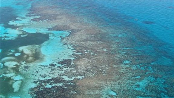

For those not familiar with shoals, like residents of the Florida Keys are very familiar, here is a picture from above looking down on shoals. There is water likely covering all of the formations (sand, coral reef) in the picture, from a few inches deep to several feet; then dropping off to "bay depth" (4 to 12 feet) on the right.

Image
Last edited by beoumont on Mon Oct 13, 2014 6:55 pm, edited 2 times in total.
0 likes   
List of 79 tropical cyclones intercepted by Richard Horodner:
http://www.canebeard.com/page/page/572246.htm

floridasun78
Category 5
Category 5
Posts: 3755
Joined: Sun May 17, 2009 10:16 pm
Location: miami fl

Re: ATL: GONZALO - Hurricane - Discussion

#495 Postby floridasun78 » Mon Oct 13, 2014 6:54 pm

who highest winds in leeward islands?
0 likes   

User avatar
TheAustinMan
Category 5
Category 5
Posts: 1047
Age: 25
Joined: Mon Jul 08, 2013 4:26 pm
Location: United States
Contact:

Re: ATL: GONZALO - Hurricane - Discussion

#496 Postby TheAustinMan » Mon Oct 13, 2014 7:06 pm

floridasun78 wrote:who highest winds in leeward islands?


I believe a station in Saint Barthélemy measured a 127 mph wind gust, which was relayed in an MFR report. The same station reported a pressure of 984 mbar and 76 mph sustained.
0 likes   
ImageImageImage
Treat my opinions with a grain of salt. For official information see your local weather service.

CrazyC83
Professional-Met
Professional-Met
Posts: 34002
Joined: Tue Mar 07, 2006 11:57 pm
Location: Deep South, for the first time!

Re: ATL: GONZALO - Hurricane - Discussion

#497 Postby CrazyC83 » Mon Oct 13, 2014 7:08 pm

TheAustinMan wrote:
floridasun78 wrote:who highest winds in leeward islands?


I believe a station in Saint Barthélemy measured a 127 mph wind gust, which was relayed in an MFR report. The same station reported a pressure of 984 mbar and 76 mph sustained.


Concurrent? Since 984/76 mph would support a 978mb pressure.
0 likes   

User avatar
TheAustinMan
Category 5
Category 5
Posts: 1047
Age: 25
Joined: Mon Jul 08, 2013 4:26 pm
Location: United States
Contact:

Re: ATL: GONZALO - Hurricane - Discussion

#498 Postby TheAustinMan » Mon Oct 13, 2014 7:09 pm

CrazyC83 wrote:
TheAustinMan wrote:
floridasun78 wrote:who highest winds in leeward islands?


I believe a station in Saint Barthélemy measured a 127 mph wind gust, which was relayed in an MFR report. The same station reported a pressure of 984 mbar and 76 mph sustained.


Concurrent? Since 984/76 mph would support a 978mb pressure.


Not concurrent; the 76 mph winds came with a falling pressure of 995 mbar. The 984 mbar report came later, and there are observations available at http://www.wunderground.com/personal-weather-station/dashboard?ID=ISAINTBA3#history
0 likes   
ImageImageImage
Treat my opinions with a grain of salt. For official information see your local weather service.

ozonepete
Professional-Met
Professional-Met
Posts: 4743
Joined: Mon Sep 07, 2009 3:23 pm
Location: From Ozone Park, NYC / Now in Brooklyn, NY

Re: ATL: GONZALO - Hurricane - Discussion

#499 Postby ozonepete » Mon Oct 13, 2014 7:11 pm

TheAustinMan wrote:
floridasun78 wrote:who highest winds in leeward islands?


I believe a station in Saint Barthélemy measured a 127 mph wind gust, which was relayed in an MFR report. The same station reported a pressure of 984 mbar and 76 mph sustained.


We were discussing this earlier. They reported a gust of 204 km/hour but it's not confirmed. It's possible it was orographically enhanced but could also be just plain bogus. It will probably be quite a while before we will know for sure. Sounds too high to be reasonable though.
0 likes   

User avatar
TheAustinMan
Category 5
Category 5
Posts: 1047
Age: 25
Joined: Mon Jul 08, 2013 4:26 pm
Location: United States
Contact:

Re: ATL: GONZALO - Hurricane - Discussion

#500 Postby TheAustinMan » Mon Oct 13, 2014 7:24 pm

ozonepete wrote:
TheAustinMan wrote:
floridasun78 wrote:who highest winds in leeward islands?


I believe a station in Saint Barthélemy measured a 127 mph wind gust, which was relayed in an MFR report. The same station reported a pressure of 984 mbar and 76 mph sustained.


We were discussing this earlier. They reported a gust of 204 km/hour but it's not confirmed. It's possible it was orographically enhanced but could also be just plain bogus. It will probably be quite a while before we will know for sure. Sounds too high to be reasonable though.


Yeah, that one gust seemed just a notch too high, but it seems likely there were at least 90 mph gusts given the persistence of those gust reports today alongside values ranging from 60-80 mph. A short YouTube clip was recently posted showing some of the conditions from Saint Barthelemey today, but at an unknown time.
0 likes   
ImageImageImage
Treat my opinions with a grain of salt. For official information see your local weather service.


Return to “2014”

Who is online

Users browsing this forum: No registered users and 2 guests