
ATL: GONZALO - Post-Tropical - Discussion
Moderator: S2k Moderators
-
Riptide

- Category 2

- Posts: 753
- Age: 34
- Joined: Fri Jul 23, 2010 3:33 pm
- Location: Cape May, New Jersey
- Contact:
Re: ATL: GONZALO - Tropical Storm - Discussion
wxman57 wrote:12Z GFS has the center passing directly over Bermuda on Friday. Perhaps this time they'll heed the warnings better.
Could potentially rival Fabian, which would be insanity even for Bermuda.
0 likes

Re:
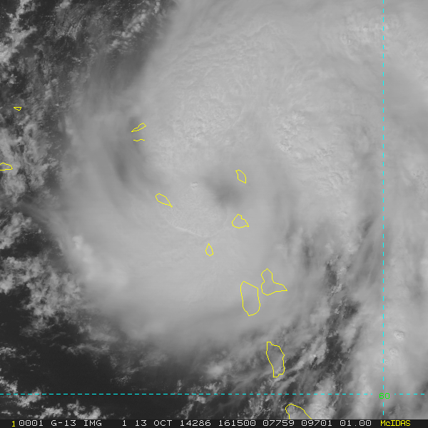
[quote="NDG"]We now have a closed eye on radar.
Where can I find that site? THX in advance
Where can I find that site? THX in advance
0 likes
The following post is NOT an official forecast and should not be used as such. It is just the opinion of the poster and may or may not be backed by sound meteorological data. It is NOT endorsed by any professional institution including storm2k.org For Official Information please refer to the NHC and NWS products.
-
supercane4867
- Category 5

- Posts: 4966
- Joined: Wed Nov 14, 2012 10:43 am
Re: ATL: GONZALO - Tropical Storm - Discussion
Eye feature also showing up on visible imagery

0 likes
-
Gustywind

- Category 5
- Posts: 12334
- Joined: Mon Sep 03, 2007 7:29 am
- Location: Baie-Mahault, GUADELOUPE
Red code is activated for the Northern Leeward Islands as TS Hurricane Gonzalo during the next hours should threat these islands.
 http://www.meteofrance.gp/integration/s ... s_nord.pdf (french version).
0 likes
-
MGC

- S2K Supporter

- Posts: 5940
- Joined: Sun Mar 23, 2003 9:05 pm
- Location: Pass Christian MS, or what is left.
Re: ATL: GONZALO - Tropical Storm - Discussion
Continues to organize....did notice what appears to be an eye on sat loop.....MGC
Last edited by MGC on Mon Oct 13, 2014 11:53 am, edited 1 time in total.
0 likes
-
SouthDadeFish

- Professional-Met

- Posts: 2836
- Joined: Thu Sep 23, 2010 2:54 pm
- Location: Miami, FL
- Contact:
-
wxman57

- Moderator-Pro Met

- Posts: 23175
- Age: 68
- Joined: Sat Jun 21, 2003 8:06 pm
- Location: Houston, TX (southwest)
Re: ATL: GONZALO - Tropical Storm - Discussion
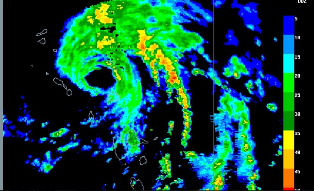
Anyone have a good link for a radar image of Gonzalo?
0 likes
-
SouthDadeFish
- Professional-Met
- Posts: 2836
- Joined: Thu Sep 23, 2010 2:54 pm
- Location: Miami, FL
- Contact:
Re: ATL: GONZALO - Tropical Storm - Discussion
wxman57 wrote:Anyone have a good link for a radar image of Gonzalo?
http://www.barbadosweather.org/Composit ... 1413156571
0 likes
-
northjaxpro

- S2K Supporter
- Posts: 8900
- Joined: Mon Sep 27, 2010 11:21 am
- Location: Jacksonville, FL
Yeah, Gonzalo looks rather impressive right now. This system may make a run at major hurricane status as it makes the turn and I pray it doesn't make a direct impact on Bermuda in a few days like Fay just did over this past weekend.
Last edited by northjaxpro on Mon Oct 13, 2014 11:56 am, edited 1 time in total.
0 likes
NEVER, EVER SAY NEVER in the tropics and weather in general, and most importantly, with life itself!!
________________________________________________________________________________________
Fay 2008 Beryl 2012 Debby 2012 Colin 2016 Hermine 2016 Julia 2016 Matthew 2016 Irma 2017 Dorian 2019
________________________________________________________________________________________
Fay 2008 Beryl 2012 Debby 2012 Colin 2016 Hermine 2016 Julia 2016 Matthew 2016 Irma 2017 Dorian 2019
-
Fego

- S2K Supporter
- Posts: 767
- Age: 66
- Joined: Sun Apr 18, 2004 7:58 pm
- Location: San Juan, Puerto Rico
- Contact:
Re: ATL: GONZALO - Tropical Storm - Discussion
wxman57 wrote:Anyone have a good link for a radar image of Gonzalo?
http://www.meteo.fr/temps/domtom/antill ... C_ant.html
0 likes
Go Giants! Go Niners! Go Warriors!


Appears completely stacked today as the radar and satellite eye are in matching points when the two are compared. Track and satellite appearance sort of remind me of Bertha in 1996 though it won't likely get nearly as far west.
0 likes
The above post is not official and should not be used as such. It is the opinion of the poster and may or may not be backed by sound meteorological data. It is not endorsed by any professional institution or storm2k.org. For official information, please refer to the NHC and NWS products.
-
weathernerdguy

- Tropical Storm

- Posts: 188
- Age: 23
- Joined: Wed Jul 10, 2013 8:44 pm
Re:
northjaxpro wrote:Yeah, Gonzalo looks rather impressive right now. This system may make a run at major hurricane status as it makes the turn and I pray it doesn't make a direct impact on Bermuda in a few days like Fay just did over this past weekend.
This is more than likely going to be the strongest storm of the season? That is, unless, the season is really ramping now....
0 likes
The posts in this forum are NOT official forecast and should not be used as such. They are just the opinion of the poster and may or may not be backed by sound meteorological data. They are NOT endorsed by any professional institution or storm2k.org. For official information, please refer to the NHC and NWS products
Who is online
Users browsing this forum: No registered users and 10 guests