Texas Fall-2014
Moderator: S2k Moderators
Forum rules

The posts in this forum are NOT official forecast and should not be used as such. They are just the opinion of the poster and may or may not be backed by sound meteorological data. They are NOT endorsed by any professional institution or STORM2K.
-
weatherdude1108
- Category 5

- Posts: 4228
- Joined: Tue Dec 13, 2011 1:04 pm
- Location: Northwest Austin/Cedar Park, TX

-
weatherdude1108
- Category 5
- Posts: 4228
- Joined: Tue Dec 13, 2011 1:04 pm
- Location: Northwest Austin/Cedar Park, TX

Baja is about to get bulldozed by one of the strongest landfalls for EPAC, pressure wise. Prayers for those there from Odile. It's streaming up mid and high level clouds into the state.

0 likes
The above post and any post by Ntxw is NOT an official forecast and should not be used as such. It is just the opinion of the poster and may or may not be backed by sound meteorological data. It is NOT endorsed by any professional institution including Storm2k. For official information, please refer to NWS products.
Help support Storm2K!
-
Portastorm

- Storm2k Moderator

- Posts: 9955
- Age: 63
- Joined: Fri Jul 11, 2003 9:16 am
- Location: Round Rock, TX
- Contact:
Re: Texas Fall-2014
Some of Odile's moisture will impact west Texas in the next few days and could even get picked up by several of these short waves pronged to move across the state this week.
0 likes
Any forecasts under my name are to be taken with a grain of salt. Get your best forecasts from the National Weather Service and National Hurricane Center.

The 12Z ECMWF looks rather dry for most of North Texas. Ditto for the 12Z GFS.
The vicious drought continues indefinitely. Seemingly perpetually.
The vicious drought continues indefinitely. Seemingly perpetually.
0 likes
The above post and any post by dhweather is NOT an official forecast and should not be used as such. It is just the opinion of the poster and may or may not be backed by sound meteorological data. It is NOT endorsed by any professional institution including storm2k.org. For official information, please refer to NWS products.
-
srainhoutx

- S2K Supporter

- Posts: 6919
- Age: 68
- Joined: Sun Jan 14, 2007 11:34 am
- Location: Haywood County, NC
- Contact:
Re: Texas Fall-2014
A very complex and complicated forecast is ahead for this week. A very noticeable 500700 mb vort max associated with a tropical wave axis (once 92L) is moving WNW across the Western Gulf. Powerful Hurricane Odile made landfall in Cabo San Lucas overnight and right of the track guidance and likely will continue heading N along or near the spine of the Baja Peninsula or Gulf of California before weakening and turning NE to ENE wringing out its abundant tropical moisture across Southern Arizona/Southern New Mexico/ Northern Mexico and Texas. Radar returns across the Midland area show moisture spreading E with the remnants of 94L and Odile. Rain chances should increase later today as the wave axis shifts W and we get into the higher moisture values on the back side of the tropical wave. We will need to closely monitor developments this week as I see the potential for flooding like we witnessed in 1994 from EPAC Hurricane Rosa. Expect the forecast to change from day to day. Embedded short wave disturbances tapping tropical moisture and no real cold front to sweep out all the developing pooling of rather high PW's until early next week raise an eyebrow and may lead to a dangerous flood event across portions of the Desert SW/Mexico as well as Texas and the Southern Plains on NE.
0 likes
Carla/Alicia/Jerry(In The Eye)/Michelle/Charley/Ivan/Dennis/Katrina/Rita/Wilma/Ike/Harvey
Member: National Weather Association
Wx Infinity Forums
http://wxinfinity.com/index.php
Facebook.com/WeatherInfinity
Twitter @WeatherInfinity
Member: National Weather Association
Wx Infinity Forums
http://wxinfinity.com/index.php
Facebook.com/WeatherInfinity
Twitter @WeatherInfinity
-
vbhoutex

- Storm2k Executive

- Posts: 29149
- Age: 74
- Joined: Wed Oct 09, 2002 11:31 pm
- Location: Cypress, TX
- Contact:
Re: Texas Fall-2014
Thanks for your take on this Steve. I have been concerned that we might get a "convergence" of systems over TX and you seem to allude to that also. Aalthough many areas of Texas need rain, we don't need flooding rains which are mostly runoff, Will be watching closely.
0 likes
Skywarn, C.E.R.T.
Please click below to donate to STORM2K to help with the expenses of keeping the site going:

Please click below to donate to STORM2K to help with the expenses of keeping the site going:
-
TheProfessor

- Professional-Met

- Posts: 3506
- Age: 29
- Joined: Tue Dec 03, 2013 10:56 am
- Location: Wichita, Kansas
Re:
TheProfessor wrote:Will North Texas get in on some of the action, or will it just be West and South Texas? We really need the rain here.
The short answer is no.
0 likes
The above post and any post by dhweather is NOT an official forecast and should not be used as such. It is just the opinion of the poster and may or may not be backed by sound meteorological data. It is NOT endorsed by any professional institution including storm2k.org. For official information, please refer to NWS products.
-
South Texas Storms

- Professional-Met
- Posts: 4259
- Joined: Thu Jun 24, 2010 12:28 am
- Location: Houston, TX
Re: Texas Fall-2014
dhweather wrote:TheProfessor wrote:Will North Texas get in on some of the action, or will it just be West and South Texas? We really need the rain here.
The short answer is no.
Actually, the past few runs of the GFS have been trending wetter across much of Texas in the next 7 days likely due to the enhanced moisture from Hurricane Odile.
0 likes
-
weatherdude1108
- Category 5
- Posts: 4228
- Joined: Tue Dec 13, 2011 1:04 pm
- Location: Northwest Austin/Cedar Park, TX
Re: Texas Fall-2014
South Texas Storms wrote:dhweather wrote:TheProfessor wrote:Will North Texas get in on some of the action, or will it just be West and South Texas? We really need the rain here.
The short answer is no.
Actually, the past few runs of the GFS have been trending wetter across much of Texas in the next 7 days likely due to the enhanced moisture from Hurricane Odile.
I like South Texas Storms' answer!
0 likes
The preceding post is NOT an official forecast, and should not be used as such. It is only the opinion of the poster and may or may not be backed by sound meteorological data. It is NOT endorsed by any professional institution including storm2k.org. For Official Information please refer to the NHC and NWS products.
Stirrings of a cold front, to be further detailed later.
0 likes
The above post and any post by Ntxw is NOT an official forecast and should not be used as such. It is just the opinion of the poster and may or may not be backed by sound meteorological data. It is NOT endorsed by any professional institution including Storm2k. For official information, please refer to NWS products.
Help support Storm2K!
Help support Storm2K!
-
srainhoutx
- S2K Supporter
- Posts: 6919
- Age: 68
- Joined: Sun Jan 14, 2007 11:34 am
- Location: Haywood County, NC
- Contact:
Re: Texas Fall-2014
Afternoon Update from Jeff:
Weak front that brought an unseasonably cool weekend with highs in the 60’s and Saturday and 70’s on Sunday is starting to wash out over the coast waters.
Weak tropical wave (remains of 92L) area progressing into the coastal waters this afternoon and will move onto the TX coast tonight. Pool of tropical moisture on the east side of this wave axis will move inland on Tuesday replacing the dry weather of the recent weekend. Additionally, weak disturbances in the NW flow aloft and weak upper level support in the form of divergence should help instigate showers and thunderstorms from Tuesday through the rest of the week. Seabreeze looks to be the main player each day with its inland march each afternoon providing the extra needed lift in a moist air mass to get storms going. Models are keying in on Tuesday and Thursday as the wettest days, but really there is little pattern chance or air mass difference for the next several days. Thursday might end up featuring a slightly better rain chance as ejecting disturbances out of powerful hurricane Odile (see below) becomes entrained in the upper level flow. Odile looks to weaken over NW MX late this week and could provide mid and upper level moisture into the SW US and TX during this time period.
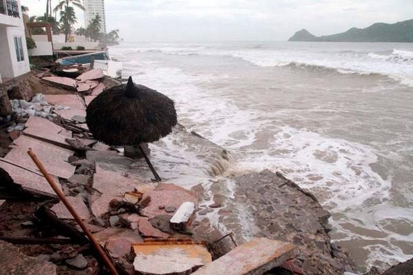
Hurricane Odile:
The strongest hurricane to strike Baja California since 1967 made landfall at Cabo San Lucas overnight with sustained winds of 125mph. Damage to the resorts, hotels, and airport is extensive. The reporting station at the airport recorded a sustained wind of 89mph with gust to 116mph and a pressure of 28.32 in before the site failed.


Weak front that brought an unseasonably cool weekend with highs in the 60’s and Saturday and 70’s on Sunday is starting to wash out over the coast waters.
Weak tropical wave (remains of 92L) area progressing into the coastal waters this afternoon and will move onto the TX coast tonight. Pool of tropical moisture on the east side of this wave axis will move inland on Tuesday replacing the dry weather of the recent weekend. Additionally, weak disturbances in the NW flow aloft and weak upper level support in the form of divergence should help instigate showers and thunderstorms from Tuesday through the rest of the week. Seabreeze looks to be the main player each day with its inland march each afternoon providing the extra needed lift in a moist air mass to get storms going. Models are keying in on Tuesday and Thursday as the wettest days, but really there is little pattern chance or air mass difference for the next several days. Thursday might end up featuring a slightly better rain chance as ejecting disturbances out of powerful hurricane Odile (see below) becomes entrained in the upper level flow. Odile looks to weaken over NW MX late this week and could provide mid and upper level moisture into the SW US and TX during this time period.
Hurricane Odile:
The strongest hurricane to strike Baja California since 1967 made landfall at Cabo San Lucas overnight with sustained winds of 125mph. Damage to the resorts, hotels, and airport is extensive. The reporting station at the airport recorded a sustained wind of 89mph with gust to 116mph and a pressure of 28.32 in before the site failed.
0 likes
Carla/Alicia/Jerry(In The Eye)/Michelle/Charley/Ivan/Dennis/Katrina/Rita/Wilma/Ike/Harvey
Member: National Weather Association
Wx Infinity Forums
http://wxinfinity.com/index.php
Facebook.com/WeatherInfinity
Twitter @WeatherInfinity
Member: National Weather Association
Wx Infinity Forums
http://wxinfinity.com/index.php
Facebook.com/WeatherInfinity
Twitter @WeatherInfinity
Re:
Ntxw wrote:Stirrings of a cold front, to be further detailed later.
That is good news. It is way too warm outside and the humidity is just plain gross. I was wondering when the next cool down was coming. Looks to be warm and muggy all week.
0 likes
-
Portastorm
- Storm2k Moderator
- Posts: 9955
- Age: 63
- Joined: Fri Jul 11, 2003 9:16 am
- Location: Round Rock, TX
- Contact:
Re: Texas Fall-2014
Well, since dhweather is going on and on about drought ... this piece linked below came out a few days ago. It's a real nice summary of drought conditions in North Texas and how things have been as of late.
http://www.srh.noaa.gov/fwd/?n=drought
http://www.srh.noaa.gov/fwd/?n=drought
0 likes
Any forecasts under my name are to be taken with a grain of salt. Get your best forecasts from the National Weather Service and National Hurricane Center.
-
Portastorm
- Storm2k Moderator
- Posts: 9955
- Age: 63
- Joined: Fri Jul 11, 2003 9:16 am
- Location: Round Rock, TX
- Contact:
Re: Texas Fall-2014
Meanwhile, here's hoping this latest QPF map from NOAA's Weather Prediction Center verifies. Much of Texas will be receiving some of that "liquid gold" in the next week!

0 likes
Any forecasts under my name are to be taken with a grain of salt. Get your best forecasts from the National Weather Service and National Hurricane Center.
-
WeatherNewbie
- Tropical Storm

- Posts: 235
- Joined: Mon Mar 22, 2010 3:42 pm
- Location: Richardson, Texas
Re: Texas Fall-2014
Portastorm wrote:Well, since dhweather is going on and on about drought ... this piece linked below came out a few days ago. It's a real nice summary of drought conditions in North Texas and how things have been as of late.
http://www.srh.noaa.gov/fwd/?n=drought
IIRC, that picture has actually improved over the summer months, which is pretty rare for Texas isn't it?
0 likes
The above post is NOT an official forecast and should not be used as such. It is just the opinion of the poster and may or may not be backed by sound meteorological data. It is NOT endorsed by any professional institution including storm2k.org. For official information, please refer to NWS products.
-
Portastorm
- Storm2k Moderator
- Posts: 9955
- Age: 63
- Joined: Fri Jul 11, 2003 9:16 am
- Location: Round Rock, TX
- Contact:
Re: Texas Fall-2014
Yes, the severity of the drought has eased *some* over much of the state from rains in the last 10-12 months. Given the encouraging El Nino signs in the last few weeks (looks like it's finally getting going and should be at least a weak Nino), the easing of the drought will continue. However, as most of us know, the longevity of the drought has been brutal and it's going to take a long, long time to get back to at least a decent spot.
Went over the relatively dry Pedernales River again today (Hwy 71) and every time I do and see how dreadful it looks, just breaks my heart. And that's a scene repeated all too much over our fine state. This Nino can't come soon enough as far as I'm concerned.
0 likes
Any forecasts under my name are to be taken with a grain of salt. Get your best forecasts from the National Weather Service and National Hurricane Center.
The EPAC is about to give birth to another potential Mexico cruiser behind Odile, just unbelievable.
0 likes
The above post and any post by Ntxw is NOT an official forecast and should not be used as such. It is just the opinion of the poster and may or may not be backed by sound meteorological data. It is NOT endorsed by any professional institution including Storm2k. For official information, please refer to NWS products.
Help support Storm2K!
Help support Storm2K!
Return to “USA & Caribbean Weather”
Who is online
Users browsing this forum: No registered users and 114 guests