ATL: CRISTOBAL - Post-Tropical - Discussion
Moderator: S2k Moderators


Re: ATL: CRISTOBAL - Hurricane - Discussion
I never thought Cristobal sounded very mean. On the other hand, the name Dottie gives me angst in my sonar plexus
0 likes


Re: ATL: CRISTOBAL - Hurricane - Discussion
I wouldn't be surprised if Cristobal makes it close to Cat 3, it has a good 48 hrs left over warm waters and only moderate windshear, relatively speaking, IMO.
The posts in this forum are NOT official forecast and should not be used as such. They are just the opinion of the poster and may or may not be backed by sound meteorological data. They are NOT endorsed by any professional institution or storm2k.org. For official information, please refer to the NHC and NWS products.
The posts in this forum are NOT official forecast and should not be used as such. They are just the opinion of the poster and may or may not be backed by sound meteorological data. They are NOT endorsed by any professional institution or storm2k.org. For official information, please refer to the NHC and NWS products.
0 likes
-
TheEuropean

- Professional-Met

- Posts: 1797
- Age: 60
- Joined: Tue Sep 20, 2005 3:17 pm
- Location: Voerde, Germany
- Contact:


-
TropicalAnalystwx13

- Category 5

- Posts: 2109
- Age: 28
- Joined: Tue Jul 19, 2011 8:20 pm
- Location: Wilmington, NC
- Contact:
-
TheEuropean
- Professional-Met
- Posts: 1797
- Age: 60
- Joined: Tue Sep 20, 2005 3:17 pm
- Location: Voerde, Germany
- Contact:
now up to 70 kt:
SUMMARY OF 800 PM EDT...0000 UTC...INFORMATION
----------------------------------------------
LOCATION...29.7N 71.5W
ABOUT 435 MI...700 KM WSW OF BERMUDA
MAXIMUM SUSTAINED WINDS...80 MPH...130 KM/H
PRESENT MOVEMENT...N OR 360 DEGREES AT 16 MPH...26 KM/H
MINIMUM CENTRAL PRESSURE...983 MB...29.03 INCHES
0 likes

Re: ATL: CRISTOBAL - Hurricane - Discussion
This is sort of off-topic but the home page shows no active storms but when I search down to this area I see
the storms you all are discussing. Do I have an old home page address or what?
Thanks
the storms you all are discussing. Do I have an old home page address or what?
Thanks
0 likes

Re:
From the Cristobal Models Thread:
Its a new reality I won't be embracing, a new hobby would be more delightful than this mess. Good thing there is a nearly infinite spectrum to weather and more than one basin .
.
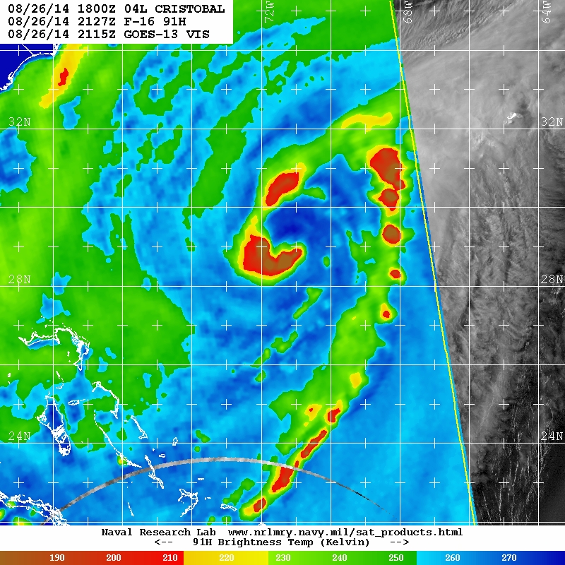
One of the last images I posted in the Hurricane Bertha thread was the worst looking image of a 65 knot tropical cyclone I have EVER SEEN. Former worse looking hurricanes don't even compare, the structure was non-existent and wouldn't even be declared an invest, just some clouds and minor showers:

This Thread:
I'm disappointed that they did not explain why it looked like that. What are the chances it would be the same twice in less than a month? Pretty good maybe, its 2014 in the Atlantic...
 Thanks, I needed that because its pretty depressing right now. 2014 Atlantic season has had neither of those two descriptors. Crummy looking CAT1 hurricanes moving out to nowhere is not quality.
Exhibit B for "why is Dvorak so trusted" question.
The mostly unremarkable 2011 and 2012 Atlantic hurricane seasons were light years ahead of 2013 and so far, 2014. I'm not really watching closely as I would be bored to tears by this activity, 3 tropical cyclones doing the same thing in the same area...and on top not amazing just strange how crummy Bertha and Cristobal appear.
blp wrote:HURAKAN wrote:typical pattern, generally unfavorable tropics, more favorable subtropics
Lol, no kidding for the last several years now, it is our new reality.
Its a new reality I won't be embracing, a new hobby would be more delightful than this mess. Good thing there is a nearly infinite spectrum to weather and more than one basin
SFLcane wrote:Yea euro keeps it weak cause of the desert out there. Looks horrible tonight. Cristobal is the most horrid looking hurricane I've ever seen. Looks like a fl afternoon t storm.
One of the last images I posted in the Hurricane Bertha thread was the worst looking image of a 65 knot tropical cyclone I have EVER SEEN. Former worse looking hurricanes don't even compare, the structure was non-existent and wouldn't even be declared an invest, just some clouds and minor showers:
This Thread:
ozonepete wrote:This is another great example of how a system that looks pretty poor on satellite can still be a hurricane:
HURRICANE CRISTOBAL DISCUSSION NUMBER 10
NWS NATIONAL HURRICANE CENTER MIAMI FL AL042014
1100 PM EDT MON AUG 25 2014
Based on a blend of SFMR, flight-level, and dropsonde wind data collected by a NOAA Hurricane Hunter aircraft a little earlier this evening, Cristobal was upgraded to a 65-kt hurricane. Similar to Hurricane Bertha earlier this year in roughly the same location, this system's cloud pattern does not resemble that of a hurricane, with little or no evidence of banding on satellite images. Some additional strengthening is expected, however, since the SHIPS guidance shows a decrease in vertical shear during the next few days, and an increase in upper-level divergence is indicated by the global models. The official intensity forecast is a little higher than the previous one, and is close to the latest LGEM guidance.
The center fixes by the NOAA aircraft indicated an eastward wobble several hours ago, but recent satellite imagery hints that a slow north-northeastward motion has resumed. The initial motion estimate is a rather uncertain 030/2 kt. In spite of the erratic motion and eastward shift of the center, the track model guidance remains in good agreement that Cristobal will move along a track similar to the previous NHC forecast. Over the next couple of days, the hurricane is expected to move through a weakness between two mid-level high pressure areas. Thereafter, as Cristobal begins to enter the mid-latitude westerlies and a shortwave trough moves off the northeast United States coastline, the tropical cyclone should accelerate northeastward into the North Atlantic. The current official forecast is not much different from the previous one, and close to the GFS ensemble mean solution.
I'm disappointed that they did not explain why it looked like that. What are the chances it would be the same twice in less than a month? Pretty good maybe, its 2014 in the Atlantic...
Hurricaneman wrote:Definitley one of those quality over quantity years
euro6208 wrote:When will the Atlantic have hurricanes that actually looked like hurricanes?
Oh Dvorak so far? Only 2.0 and likely only a depression if it were somewhere else.
Exhibit B for "why is Dvorak so trusted" question.
somethingfunny wrote:This is my favorite season to track since 2010. What a bizarre little over performing storm.
The mostly unremarkable 2011 and 2012 Atlantic hurricane seasons were light years ahead of 2013 and so far, 2014. I'm not really watching closely as I would be bored to tears by this activity, 3 tropical cyclones doing the same thing in the same area...and on top not amazing just strange how crummy Bertha and Cristobal appear.
0 likes

Re: ATL: CRISTOBAL - Hurricane - Discussion
TheEuropean wrote:eyewall not closed yet:
(NRL)
Is it unusual to have that pressure wihout an eyewall yet? And thanks for updating recon for us.
0 likes
-
cycloneye

- Admin

- Posts: 149542
- Age: 69
- Joined: Thu Oct 10, 2002 10:54 am
- Location: San Juan, Puerto Rico
Re: ATL: CRISTOBAL - Hurricane - Discussion
00z Best Track up to 70kts.
AL, 04, 2014082700, , BEST, 0, 297N, 715W, 70, 983, HU
AL, 04, 2014082700, , BEST, 0, 297N, 715W, 70, 983, HU
0 likes
Visit the Caribbean-Central America Weather Thread where you can find at first post web cams,radars
and observations from Caribbean basin members Click Here
and observations from Caribbean basin members Click Here
-
CrazyC83
- Professional-Met
- Posts: 34315
- Joined: Tue Mar 07, 2006 11:57 pm
- Location: Deep South, for the first time!
Re: ATL: CRISTOBAL - Hurricane - Discussion
artist wrote:TheEuropean wrote:eyewall not closed yet:
(NRL)
Is it unusual to have that pressure wihout an eyewall yet? And thanks for updating recon for us.
Not counting storms transitioning to extratropical (in which I have seen 950s without an eyewall), it isn't too common.
0 likes
-
Hurricaneman

- Category 5
- Posts: 7404
- Age: 45
- Joined: Tue Aug 31, 2004 3:24 pm
- Location: central florida
Re: ATL: CRISTOBAL - Hurricane - Discussion
CrazyC83 wrote:artist wrote:TheEuropean wrote:eyewall not closed yet:
(NRL)
Is it unusual to have that pressure wihout an eyewall yet? And thanks for updating recon for us.
Not counting storms transitioning to extratropical (in which I have seen 950s without an eyewall), it isn't too common.
Earl in 1998 was a cat 2 hurricane without an eyewall so maybe this could be similar to that
0 likes
Re: ATL: CRISTOBAL - Hurricane - Discussion
CrazyC83 wrote:artist wrote:TheEuropean wrote:eyewall not closed yet:
(NRL)
Is it unusual to have that pressure wihout an eyewall yet? And thanks for updating recon for us.
Not counting storms transitioning to extratropical (in which I have seen 950s without an eyewall), it isn't too common.
Thanks, Crazy.
0 likes
-
jaguarjace

- Category 4

- Posts: 975
- Age: 31
- Joined: Sat Jun 11, 2011 7:38 am
- Location: Khon Kaen, Thailand
Re: ATL: CRISTOBAL - Hurricane - Discussion
Interesting stuff going on here.
0 likes
Owner of the Tropical Archive YouTube channel
Web Developer at Force Thirteen
Twitter/X : @force13_support
Web Developer at Force Thirteen
Twitter/X : @force13_support
-
Hurricaneman
- Category 5
- Posts: 7404
- Age: 45
- Joined: Tue Aug 31, 2004 3:24 pm
- Location: central florida
Re: ATL: CRISTOBAL - Hurricane - Discussion
jaguarjace wrote:
Interesting stuff going on here.
is it me or are those systems to the NE of Cristobal pieces that broke off and became lows themselves
The posts in this forum are NOT official forecast and should not be used as such. They are just the opinion of the poster and may or may not be backed by sound meteorological data. They are NOT endorsed by any professional institution or storm2k.org. For official information, please refer to the NHC and NWS products
0 likes
-
USTropics
- Professional-Met
- Posts: 2739
- Joined: Sun Aug 12, 2007 3:45 am
- Location: Florida State University
Re: ATL: CRISTOBAL - Hurricane - Discussion
Hurricaneman wrote:jaguarjace wrote:Interesting stuff going on here.
is it me or are those systems to the NE of Cristobal pieces that broke off and became lows themselves
The posts in this forum are NOT official forecast and should not be used as such. They are just the opinion of the poster and may or may not be backed by sound meteorological data. They are NOT endorsed by any professional institution or storm2k.org. For official information, please refer to the NHC and NWS products
Those are both upper-level lows in association with the trough (refer to OPC surface analysis graphic below). It's essentially a region of positive vorticity caused by counterclockwise curvature around the upper level trough and counterclockwise shear associated with the speed shear of a jet streak. Furthermore, that particular setup would most likely qualify as a double-barrel low pressure system (something more common in fall/winter).

0 likes


Re: ATL: CRISTOBAL - Hurricane - Discussion
hipshot wrote:This is sort of off-topic but the home page shows no active storms but when I search down to this area I see
the storms you all are discussing. Do I have an old home page address or what?
Thanks
There's a thread about 15 threads down about it. Long story short...nobody has an answer and it's your fault.
0 likes
Andrew '92 Opal '95 Blizzard '96 Izzy '03 Irene '11 Sandy '12
The following post is NOT an official forecast and should not be used as such. It is just the opinion is not be backed by sound meteorological data. It is NOT endorsed by any professional institution including storm2k.org For Official Information please refer to the NHC and NWS products.
The following post is NOT an official forecast and should not be used as such. It is just the opinion is not be backed by sound meteorological data. It is NOT endorsed by any professional institution including storm2k.org For Official Information please refer to the NHC and NWS products.
-
HurricaneRyan
- Category 3

- Posts: 846
- Age: 32
- Joined: Sun Dec 05, 2010 3:05 pm
Who is online
Users browsing this forum: No registered users and 51 guests