ATL: CRISTOBAL - Post-Tropical - Discussion
Moderator: S2k Moderators
-
floridasun78
- Category 5

- Posts: 3755
- Joined: Sun May 17, 2009 10:16 pm
- Location: miami fl
Re: ATL: CRISTOBAL - Tropical Storm - Discussion
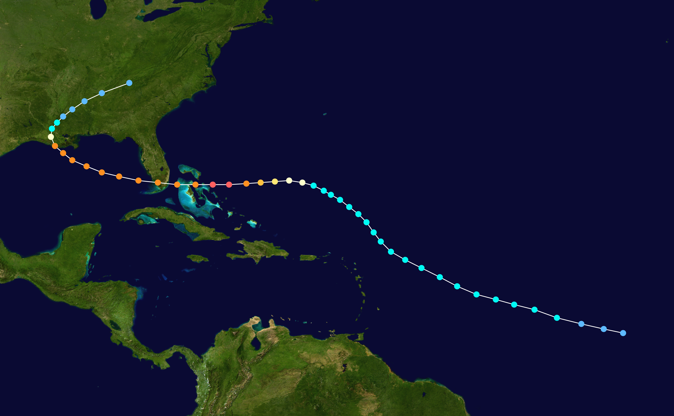
crimi481 wrote:Kinda similar to Andrew track scenario. All models had it lifting N and N.E.. but 2 troughs missed it
and ridging built in to its north -send it west. Is possible here.
ANDREW
http://upload.wikimedia.org/wikipedia/c ... _track.png
** I am not a Pro
Andrew was NEVER forecast to recurve. It as always forecast to move toward the USA. It was forecast to hit N Florida or the Carolinas, however, and it was forecast to move slower. However, at no point was a recurve ever forecast
0 likes
-
CYCLONE MIKE
- Category 5
- Posts: 2183
- Joined: Tue Aug 31, 2004 6:04 pm
- Location: Gonzales, LA
Re:
HURAKAN wrote:I just think people are reading too much into these wobbles which were perfectly predicted by the models, showing the system basically stationary for 24 hours or so
I agree. Models have shown this drifting slowly north til Tuesday then finally accelerating ne out to sea. And like alyono said nothing like Andrew track.
0 likes


-
ozonepete
- Professional-Met

- Posts: 4743
- Joined: Mon Sep 07, 2009 3:23 pm
- Location: From Ozone Park, NYC / Now in Brooklyn, NY
Re: ATL: CRISTOBAL - Tropical Storm - Discussion
Well from all of this discussion and how I know the NHC works, I would say they are just going to say it's on target and leave it at that. They might mention what looks like a small counterclockwise loop. Other than that I don't expect anything.
0 likes
-
ozonepete
- Professional-Met
- Posts: 4743
- Joined: Mon Sep 07, 2009 3:23 pm
- Location: From Ozone Park, NYC / Now in Brooklyn, NY
Re: ATL: CRISTOBAL - Tropical Storm - Discussion
Alyono wrote:crimi481 wrote:Kinda similar to Andrew track scenario. All models had it lifting N and N.E.. but 2 troughs missed it
and ridging built in to its north -send it west. Is possible here.
ANDREW
http://upload.wikimedia.org/wikipedia/c ... _track.png
** I am not a Pro
Andrew was NEVER forecast to recurve. It as always forecast to move toward the USA. It was forecast to hit N Florida or the Carolinas, however, and it was forecast to move slower. However, at no point was a recurve ever forecast
Yup. I remember it quite well. You have it right.
0 likes


There's a ridge to it's east, can't go too far that way. There's a ridge to it's west, can't go too far that way either. Wobble around, relocate centers or just meandering until it gets more organized then slowly move north and NE into the weakness. That's what the models have been showing. Nothing alarming at this time from it one big, hot mess. Just my two cents of interpretation.
0 likes
The above post and any post by Ntxw is NOT an official forecast and should not be used as such. It is just the opinion of the poster and may or may not be backed by sound meteorological data. It is NOT endorsed by any professional institution including Storm2k. For official information, please refer to NWS products.
Help support Storm2K!

-
SapphireSea
- Category 1

- Posts: 430
- Joined: Wed Aug 24, 2005 12:13 pm
- Location: Miami, FL
Re: ATL: CRISTOBAL - Tropical Storm - Discussion
ozonepete wrote:Alyono wrote:crimi481 wrote:Kinda similar to Andrew track scenario. All models had it lifting N and N.E.. but 2 troughs missed it
and ridging built in to its north -send it west. Is possible here.
ANDREW
http://upload.wikimedia.org/wikipedia/c ... _track.png
** I am not a Pro
Andrew was NEVER forecast to recurve. It as always forecast to move toward the USA. It was forecast to hit N Florida or the Carolinas, however, and it was forecast to move slower. However, at no point was a recurve ever forecast
Yup. I remember it quite well. You have it right.
Yeah I remember that when Andrew was entering the Bahamas they mentioned all models were in agreement to a 270 heading through at least 48 hours. There was the issue of forward speed, but there was mention that we would have very little time due to it already moving quickly in this stage. Also, the ridge that pinched off that trof had an axis further south and extended from west atlantic to mid gulf states.
Looking at WV though, that next piece of energy in the plains looks pretty rugged. That should settle this and likely 97l down the road if I had to guess.
0 likes
Forecast Disclaimer:
Don't be stupid. Make your own informed decisions.
Don't be stupid. Make your own informed decisions.
-
northjaxpro

- S2K Supporter

- Posts: 8900
- Joined: Mon Sep 27, 2010 11:21 am
- Location: Jacksonville, FL
Re:
Ntxw wrote:There's a ridge to it's east, can't go too far that way. There's a ridge to it's west, can't go too far that way either. Wobble around, relocate centers or just meandering until it gets more organized then slowly move north and NE into the weakness. That's what the models have been showing. Nothing alarming at this time from it one big, hot mess. Just my two cents of interpretation.
That pretty much sums up the situation in a nutshell Ntxw.
0 likes
NEVER, EVER SAY NEVER in the tropics and weather in general, and most importantly, with life itself!!
________________________________________________________________________________________
Fay 2008 Beryl 2012 Debby 2012 Colin 2016 Hermine 2016 Julia 2016 Matthew 2016 Irma 2017 Dorian 2019
________________________________________________________________________________________
Fay 2008 Beryl 2012 Debby 2012 Colin 2016 Hermine 2016 Julia 2016 Matthew 2016 Irma 2017 Dorian 2019
After reading the NHC discussion it all makes sense - the eventual NE track remains the same or even faster...
As said in the TCD, the convection to the south is just that and not the center itself - very good reasoning by the NHC forcaster, considering how confusing the images have been to the eye...
Frank
As said in the TCD, the convection to the south is just that and not the center itself - very good reasoning by the NHC forcaster, considering how confusing the images have been to the eye...
Frank
0 likes

-
paintplaye
- Category 1
- Posts: 380
- Joined: Sun Jul 20, 2008 11:25 pm
Re:
Frank2 wrote:Looking at the above loop it seems the system (except for the remnant LLC) may have merged with the trough and the entire system will continue to move NE (just my own thoughts though I think someone else mentioned this earlier)...
Part of the system did merge with the trough but the trough has passed the point of really pulling the whole system North. It looks like the low level center (or what is left of it) has dived south under the mid level center. Probably won't see this move North or NE until late Monday into Tuesday morning.
0 likes

Recon is headed back out they will probably find pressures have dropped below 995 MB.
The convection is increasing and the LLC may have been pulled south under it.
Often when a trough misses there is some southwest drift behind the front.
If Cristobal had made it above 25 N I think the current trough would have taken her off to the ENE.
You need an asymptotic model algorythm to handle a situation like this.
0 likes
-
ozonepete
- Professional-Met
- Posts: 4743
- Joined: Mon Sep 07, 2009 3:23 pm
- Location: From Ozone Park, NYC / Now in Brooklyn, NY
Re: ATL: CRISTOBAL - Tropical Storm - Discussion
I get it all and agree with the overall forecast except for that it's currently moving north at 5 mph. Not even the naked swirl that they have as the center has moved north at all in the last 6 hours. But none of this is going to matter in the long run. It will eventually move north and then northeast. Nothing in the wide synoptic view shows anything different.
0 likes

Re: ATL: CRISTOBAL - Tropical Storm - Discussion
There's a small convective blowup on the north end of the main ball, based on the RGB satellite (which I really should've been using for night guesses anyway) it looks like the center may be just outside of that convection to the north.
0 likes
The above post is not official and should not be used as such. It is the opinion of the poster and may or may not be backed by sound meteorological data. It is not endorsed by any professional institution or storm2k.org. For official information, please refer to the NHC and NWS products.
-
AtlanticWind

- S2K Supporter
- Posts: 1898
- Age: 67
- Joined: Sun Aug 08, 2004 9:57 pm
- Location: Plantation,Fla
Re: ATL: CRISTOBAL - Tropical Storm - Discussion
Alyono wrote:crimi481 wrote:Kinda similar to Andrew track scenario. All models had it lifting N and N.E.. but 2 troughs missed it
and ridging built in to its north -send it west. Is possible here.
ANDREW
http://upload.wikimedia.org/wikipedia/c ... _track.png
** I am not a Pro
Andrew was NEVER forecast to recurve. It as always forecast to move toward the USA. It was forecast to hit N Florida or the Carolinas, however, and it was forecast to move slower. However, at no point was a recurve ever forecast
Early on there was some thought andrew could recurve
From NHC archives
http://www.nhc.noaa.gov/archive/storm_w ... al0492.006
0 likes
-
Hybridstorm_November2001

- S2K Supporter
- Posts: 2817
- Joined: Sat Aug 21, 2004 2:50 pm
- Location: SW New Brunswick, Canada
- Contact:
Re: ATL: CRISTOBAL - Tropical Storm - Discussion
AtlanticWind wrote:Alyono wrote:crimi481 wrote:Kinda similar to Andrew track scenario. All models had it lifting N and N.E.. but 2 troughs missed it
and ridging built in to its north -send it west. Is possible here.
ANDREW
http://upload.wikimedia.org/wikipedia/c ... _track.png
** I am not a Pro
Andrew was NEVER forecast to recurve. It as always forecast to move toward the USA. It was forecast to hit N Florida or the Carolinas, however, and it was forecast to move slower. However, at no point was a recurve ever forecast
Early on there was some thought andrew could recurve
From NHC archives
http://www.nhc.noaa.gov/archive/storm_w ... al0492.006
Keep in mind the science behind track forecasting has advanced by leaps and bounds in the twenty-two years since Andrew made landfall.
0 likes

Re: ATL: CRISTOBAL - Tropical Storm - Discussion
I just don't see the llc where the NHC has it at INIT 25/0300Z 24.8N 73.1W. I know this is IR2 but there is no spin going on there at all. I have a feeling it further south or dipped slightly SSW. I am seeing some spin around 23.8 and 73.2.
http://www.ssd.noaa.gov/PS/TROP/floaters/04L/imagery/swir_lalo-animated.gif
I disagree a little with those that say this does not matter. The margins are very tight with this system it is not like we are talking about some sweeping trough off the east coast to pick this up. The thing that would alarm me is if we see SW movement then that could put the Ridge to the West in play. You guys are probably right in the end and we are probably going to see an OTS scenario but this is what this forum is about.
EDIT: NDG, sorry I just saw your post with a similar observation.
Last edited by blp on Sun Aug 24, 2014 10:37 pm, edited 1 time in total.
0 likes
The following post is NOT an official forecast and should not be used as such. It is just the opinion of the poster and may or may not be backed by sound meteorological data. It is NOT endorsed by any professional institution including storm2k.org For Official Information please refer to the NHC and NWS products.
Who is online
Users browsing this forum: No registered users and 12 guests