ATL: CRISTOBAL - Post-Tropical - Discussion

Moderator: S2k Moderators

Message
Author
hectopascal

#1221 Postby hectopascal » Sat Aug 23, 2014 9:24 pm

----- Current Analysis -----
Date : 24 AUG 2014 Time : 004500 UTC
Lat : 22:14:54 N Lon : 72:46:12 W


CI# /Pressure/ Vmax
2.1 /1005.8mb/ 31.0kt


Final T# Adj T# Raw T#
2.1 2.2 2.2

Center Temp : -19.2C Cloud Region Temp : -38.3C

Scene Type : CURVED BAND with 0.42 ARC in LT GRAY
Maximum CURVED BAND with 0.80 ARC in LT GRAY
at Lat: 23:02:24 N Lon: 72:10:11 W

Positioning Method : FORECAST INTERPOLATION

Ocean Basin : ATLANTIC

Outlook for TC Intensification Based on Current
Env. Shear Values and MPI Differential
Forecast Interval : 6hr 12hr 18hr 24hr
F F F F

Image


Loooking at all data.
0 likes   

User avatar
nativefloridian
Tropical Storm
Tropical Storm
Posts: 172
Joined: Tue Aug 21, 2012 2:48 pm
Location: Pembroke Pines, FL

#1222 Postby nativefloridian » Sat Aug 23, 2014 9:29 pm

Doesn't appear to be moving much at the moment. :?:
0 likes   

Alyono
Professional-Met
Professional-Met
Posts: 6961
Joined: Fri Apr 26, 2013 3:52 pm
Location: Texas Coast

#1223 Postby Alyono » Sat Aug 23, 2014 9:32 pm

there is an outflow restriction, which will slow intensification, but not much shear over the center
0 likes   

crimi481
Category 2
Category 2
Posts: 602
Joined: Thu Sep 09, 2004 4:47 pm

Re: ATL: FOUR - Tropical Depression - Discussion

#1224 Postby crimi481 » Sat Aug 23, 2014 9:35 pm

http://www.ssd.noaa.gov/goes/east/watl/flash-bd.html

I am no pro, but it appears the entire N. half of storm will shed itself off to the north.
Leaving the LOW center to move more W. WNW.
0 likes   

tolakram
Admin
Admin
Posts: 20009
Age: 62
Joined: Sun Aug 27, 2006 8:23 pm
Location: Florence, KY (name is Mark)

Re: ATL: FOUR - Tropical Depression - Discussion

#1225 Postby tolakram » Sat Aug 23, 2014 9:35 pm

0 likes   
M a r k
- - - - -
Join us in chat: Storm2K Chatroom Invite. Android and IOS apps also available.

The posts in this forum are NOT official forecasts and should not be used as such. Posts are NOT endorsed by any professional institution or STORM2K.org. For official information and forecasts, please refer to NHC and NWS products.

User avatar
gatorcane
S2K Supporter
S2K Supporter
Posts: 23691
Age: 47
Joined: Sun Mar 13, 2005 3:54 pm
Location: Boca Raton, FL

#1226 Postby gatorcane » Sat Aug 23, 2014 9:37 pm

Look at the trough digging now in this WV loop....nice exit route setting up for our TD which should keep it east of the U.S.:

Image

The posts in this forum are NOT official forecast and should not be used as such. They are just the opinion of the poster and may or may not be backed by sound meteorological data. They are NOT endorsed by any professional institution or storm2k.org. For official information, please refer to the NHC and NWS products.
0 likes   

User avatar
blp
Category 5
Category 5
Posts: 2840
Age: 46
Joined: Thu Sep 09, 2004 7:51 pm
Location: Miami, FL
Contact:

Re: ATL: FOUR - Tropical Depression - Discussion

#1227 Postby blp » Sat Aug 23, 2014 9:44 pm

Is it me or does the llc look to be moving more west.

http://www.ssd.noaa.gov/PS/TROP/floaters/04L/imagery/swir_lalo-animated.gif
0 likes   
The following post is NOT an official forecast and should not be used as such. It is just the opinion of the poster and may or may not be backed by sound meteorological data. It is NOT endorsed by any professional institution including storm2k.org For Official Information please refer to the NHC and NWS products.

User avatar
Blown Away
S2K Supporter
S2K Supporter
Posts: 10145
Joined: Wed May 26, 2004 6:17 am

Re: ATL: FOUR - Tropical Depression - Discussion

#1228 Postby Blown Away » Sat Aug 23, 2014 9:50 pm

blp wrote:Is it me or does the llc look to be moving more west.

http://www.ssd.noaa.gov/PS/TROP/floaters/04L/imagery/swir_lalo-animated.gif


That's weird, sure does look like a LLC moving W... Probably some kind of eddy... Interesting...
0 likes   
Hurricane Eye Experience: David 79, Irene 99, Frances 04, Jeanne 04, Wilma 05... EYE COMING MY WAY IN 2024…
Hurricane Brush Experience: Andrew 92, Erin 95, Floyd 99, Matthew 16, Irma 17, Ian 22, Nicole 22…

ninel conde

Re:

#1229 Postby ninel conde » Sat Aug 23, 2014 9:54 pm

gatorcane wrote:Look at the trough digging now in this WV loop....nice exit route setting up for our TD which should keep it east of the U.S.:

Image

The posts in this forum are NOT official forecast and should not be used as such. They are just the opinion of the poster and may or may not be backed by sound meteorological data. They are NOT endorsed by any professional institution or storm2k.org. For official information, please refer to the NHC and NWS products.


you dont see powerful trofs like that in august alot. i think its pretty amazing td4 formed at all.
0 likes   

User avatar
Blown Away
S2K Supporter
S2K Supporter
Posts: 10145
Joined: Wed May 26, 2004 6:17 am

Re: ATL: FOUR - Tropical Depression - Discussion

#1230 Postby Blown Away » Sat Aug 23, 2014 9:55 pm

The UKMET and the NAVGEM models build enough ridging north of
the cyclone to steer it across Florida and into the Gulf of Mexico.


First time the NHC or NWS has even mentioned this option... Seems a recurve was getting more likely...
0 likes   
Hurricane Eye Experience: David 79, Irene 99, Frances 04, Jeanne 04, Wilma 05... EYE COMING MY WAY IN 2024…
Hurricane Brush Experience: Andrew 92, Erin 95, Floyd 99, Matthew 16, Irma 17, Ian 22, Nicole 22…

ozonepete
Professional-Met
Professional-Met
Posts: 4743
Joined: Mon Sep 07, 2009 3:23 pm
Location: From Ozone Park, NYC / Now in Brooklyn, NY

Re:

#1231 Postby ozonepete » Sat Aug 23, 2014 10:08 pm

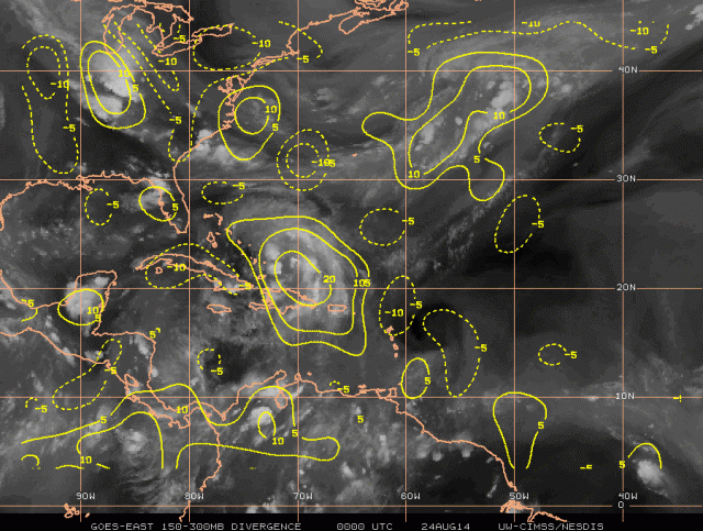
Alyono wrote:there is an outflow restriction, which will slow intensification, but not much shear over the center


Exactly, Alyono. Shear has dropped but there is some subsidence over the western semicircle which should subside in 24 hours. Look at how upper level divergence is really restricted to the west (dashed lines). This shows the effects of the outflow restriction you referred to.

Image
0 likes   

User avatar
bahamaswx
Category 5
Category 5
Posts: 1542
Joined: Sat Sep 13, 2003 1:11 am
Location: Georgetown, Bahamas

Re: ATL: FOUR - Tropical Depression - Discussion

#1232 Postby bahamaswx » Sat Aug 23, 2014 11:00 pm

Restricted outflow to the west should spare most of the Bahamas from flooding rainfall. :sun:
0 likes   

User avatar
chaser1
S2K Supporter
S2K Supporter
Posts: 5464
Age: 64
Joined: Sat Oct 15, 2005 5:59 pm
Location: Longwood, Fl

Re: ATL: FOUR - Tropical Depression - Discussion

#1233 Postby chaser1 » Sun Aug 24, 2014 12:05 am

There is not a satellite resolution that exists that could help me pick out a center or attempt to guess forward motion from that "soup" called a tropical depression.
0 likes   
Andy D

(For official information, please refer to the NHC and NWS products.)

User avatar
Hammy
Category 5
Category 5
Posts: 5849
Age: 41
Joined: Fri May 25, 2012 5:25 pm
Contact:

Re: ATL: FOUR - Tropical Depression - Discussion

#1234 Postby Hammy » Sun Aug 24, 2014 12:12 am

chaser1 wrote:There is not a satellite resolution that exists that could help me pick out a center or attempt to guess forward motion from that "soup" called a tropical depression.


Rapidscan satellite and banding give me the impression that the center is just northeast of the area between Inagua and the Turks and Caicos islands, and appears to be tightening up and becoming more compact.
0 likes   
The above post is not official and should not be used as such. It is the opinion of the poster and may or may not be backed by sound meteorological data. It is not endorsed by any professional institution or storm2k.org. For official information, please refer to the NHC and NWS products.

User avatar
chaser1
S2K Supporter
S2K Supporter
Posts: 5464
Age: 64
Joined: Sat Oct 15, 2005 5:59 pm
Location: Longwood, Fl

Re: ATL: FOUR - Tropical Depression - Discussion

#1235 Postby chaser1 » Sun Aug 24, 2014 12:17 am

Thanks Hammy... :D do you have a link for the rapidscan?
0 likes   
Andy D

(For official information, please refer to the NHC and NWS products.)

tolakram
Admin
Admin
Posts: 20009
Age: 62
Joined: Sun Aug 27, 2006 8:23 pm
Location: Florence, KY (name is Mark)

Re: ATL: FOUR - Tropical Depression - Discussion

#1236 Postby tolakram » Sun Aug 24, 2014 12:21 am

Recon is about to do a center fix.
0 likes   
M a r k
- - - - -
Join us in chat: Storm2K Chatroom Invite. Android and IOS apps also available.

The posts in this forum are NOT official forecasts and should not be used as such. Posts are NOT endorsed by any professional institution or STORM2K.org. For official information and forecasts, please refer to NHC and NWS products.

User avatar
chaser1
S2K Supporter
S2K Supporter
Posts: 5464
Age: 64
Joined: Sat Oct 15, 2005 5:59 pm
Location: Longwood, Fl

Re: ATL: FOUR - Tropical Depression - Discussion

#1237 Postby chaser1 » Sun Aug 24, 2014 12:27 am

...drum roll....... though i'm guessing a crawl to the NW.
0 likes   
Andy D

(For official information, please refer to the NHC and NWS products.)

User avatar
Hammy
Category 5
Category 5
Posts: 5849
Age: 41
Joined: Fri May 25, 2012 5:25 pm
Contact:

Re: ATL: FOUR - Tropical Depression - Discussion

#1238 Postby Hammy » Sun Aug 24, 2014 12:28 am

chaser1 wrote:Thanks Hammy... :D do you have a link for the rapidscan?


http://weather.msfc.nasa.gov/GOES/goeseastconusir.html It's the IR1 here, 30 frames; I'm not sure how to copy the full loop link though Ithe loop just has the same link as the main page for me).

tolakram wrote:Recon is about to do a center fix.


Possible tropical storm winds in SE quad, hopefully they can complete a NE-SW pass prior to the advisory.
Last edited by Hammy on Sun Aug 24, 2014 12:30 am, edited 1 time in total.
0 likes   
The above post is not official and should not be used as such. It is the opinion of the poster and may or may not be backed by sound meteorological data. It is not endorsed by any professional institution or storm2k.org. For official information, please refer to the NHC and NWS products.

tolakram
Admin
Admin
Posts: 20009
Age: 62
Joined: Sun Aug 27, 2006 8:23 pm
Location: Florence, KY (name is Mark)

Re: ATL: FOUR - Tropical Depression - Discussion

#1239 Postby tolakram » Sun Aug 24, 2014 12:29 am

Image
0 likes   
M a r k
- - - - -
Join us in chat: Storm2K Chatroom Invite. Android and IOS apps also available.

The posts in this forum are NOT official forecasts and should not be used as such. Posts are NOT endorsed by any professional institution or STORM2K.org. For official information and forecasts, please refer to NHC and NWS products.

User avatar
bahamaswx
Category 5
Category 5
Posts: 1542
Joined: Sat Sep 13, 2003 1:11 am
Location: Georgetown, Bahamas

#1240 Postby bahamaswx » Sun Aug 24, 2014 12:31 am

Just north of Mayaguana. Ever so slightly right of track.
0 likes   


Return to “2014”

Who is online

Users browsing this forum: No registered users and 1 guest