ATL: CRISTOBAL - Post-Tropical - Discussion

Moderator: S2k Moderators

Message
Author
TheStormExpert

Re:

#1061 Postby TheStormExpert » Sat Aug 23, 2014 12:59 pm

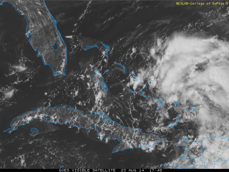
Alyono wrote:aircraft also found the pressure has risen by about 1 mb

Development today appears unlikely. Simply no organization Should become a TD or a TS tomorrow morning

Then yet again tomorrow development won't happen, starting to get kind of old with this invest. :x
0 likes   

User avatar
Hammy
Category 5
Category 5
Posts: 5849
Age: 41
Joined: Fri May 25, 2012 5:25 pm
Contact:

Re: ATL: INVEST 96L - Discussion

#1062 Postby Hammy » Sat Aug 23, 2014 1:06 pm

How long now has "tomorrow" been the point of formation? There is too much shear and now dry air entering into the western side of the "circulation", I don't see how this can develop at this point. Conditions are far worse than any of the models predicted so more than likely they're wrong on development as well.
0 likes   
The above post is not official and should not be used as such. It is the opinion of the poster and may or may not be backed by sound meteorological data. It is not endorsed by any professional institution or storm2k.org. For official information, please refer to the NHC and NWS products.

User avatar
Evil Jeremy
S2K Supporter
S2K Supporter
Posts: 5463
Age: 32
Joined: Mon Apr 10, 2006 2:10 pm
Location: Los Angeles, CA

Re: ATL: INVEST 96L - Discussion

#1063 Postby Evil Jeremy » Sat Aug 23, 2014 1:09 pm

As far as I'm concerned, development is a matter of "when", not "if". The system is so close, and model support is too strong to think this is about to fall apart.

The posts in this forum are NOT official forecast and should not be used as such. They are just the opinion of the poster and may or may not be backed by sound meteorological data. They are NOT endorsed by any professional institution or storm2k.org. For official information, please refer to the NHC and NWS products.
0 likes   
Frances 04 / Jeanne 04 / Katrina 05 / Wilma 05 / Fay 08 / Debby 12 / Andrea 13 / Colin 16 / Hermine 16 / Matthew 16 / Irma 17

OuterBanker
S2K Supporter
S2K Supporter
Posts: 1731
Joined: Wed Feb 26, 2003 10:53 am
Location: Nags Head, NC
Contact:

Re: ATL: INVEST 96L - Discussion

#1064 Postby OuterBanker » Sat Aug 23, 2014 1:13 pm

I know there’s a lot of impatience around here. At least NOAA is getting a lot of experience flying into it. NOAA43 just took off for their first run. Obviously they are not writing it off yet.
0 likes   

User avatar
SFLcane
S2K Supporter
S2K Supporter
Posts: 10163
Age: 47
Joined: Sat Jun 05, 2010 1:44 pm
Location: Lake Worth Florida

Re: ATL: INVEST 96L - Discussion

#1065 Postby SFLcane » Sat Aug 23, 2014 1:25 pm

In full view.... :roll:

Image
0 likes   

Rail Dawg
S2K Supporter
S2K Supporter
Posts: 326
Joined: Mon Aug 27, 2012 5:02 pm
Location: Where the eye makes landfall.

Re: ATL: INVEST 96L - Discussion

#1066 Postby Rail Dawg » Sat Aug 23, 2014 1:25 pm

I smile because back in the day we had to wait for the polar satellite to pass over us so we could get just a few still images.

Now there is so much information it's just plain incredible.

And yet we STILL don't know for certain!

Chuck
0 likes   
Although I have been a hurricane forecaster since 1980 that only means I've been wrong lots of times.

SeGaBob

#1067 Postby SeGaBob » Sat Aug 23, 2014 1:32 pm

We've been saying tomorrow for the last couple of days now... also we've said within 12 hours a few times. Just last night the "center" was supposed to be closing off in a few hours. I feel development will happen but it may be longer than some want to wait...


Personal Forecast Disclaimer:
The posts in this forum are NOT official forecast and should not be used as such. They are just the opinion of the poster and may or may not be backed by sound meteorological data. They are NOT endorsed by any professional institution or storm2k.org. For official information, please refer to the NHC and NWS products.
0 likes   

Airboy
Category 1
Category 1
Posts: 439
Joined: Wed Jul 27, 2011 10:41 am

#1068 Postby Airboy » Sat Aug 23, 2014 1:32 pm

Looks like the recon found some west winds, lets see if it can be something
0 likes   
Personal Forecast Disclaimer:
The posts in this forum are NOT official forecast and should not be used as such. They are just the opinion of the poster and may or may not be backed by sound meteorological data. They are NOT endorsed by any professional institution or storm2k.org. For official information, please refer to the NHC and NWS products.

User avatar
baytownwx
Tropical Depression
Tropical Depression
Posts: 66
Joined: Tue Jun 19, 2012 10:38 am

#1069 Postby baytownwx » Sat Aug 23, 2014 1:33 pm

Image

After looking at so many loops today, one could make the argument that the sustained convection south of Hispaniola could possibly work a low down to the surface (of course it will take a while to simmer). While the designated spot of 96L gets pulled north with the trough. Either way this system is a mess and will take awhile to get its act together.
0 likes   
The following post is NOT an official forecast and should not be used as such. It is just the opinion of the poster and may or may not be backed by sound meteorological data. It is NOT endorsed by storm2k.org.

User avatar
Weatherboy1
Category 5
Category 5
Posts: 1189
Age: 49
Joined: Mon Jul 05, 2004 1:50 pm
Location: Jupiter/Sarasota, FL

#1070 Postby Weatherboy1 » Sat Aug 23, 2014 1:35 pm

Inflow from the south and southwest had been hindered by the mountains of hispanola for a while. My guess is now that the center is headig far enough west, that won't be a problem and it will draw more moisture in from that quadrant. That could help it pop!
0 likes   

User avatar
tropicwatch
Category 5
Category 5
Posts: 3385
Age: 61
Joined: Sat Jun 02, 2007 10:01 am
Location: Panama City Florida
Contact:

#1071 Postby tropicwatch » Sat Aug 23, 2014 1:36 pm

Recon finding west winds in the area of 21.51N 72.15W on more than one reading
Last edited by tropicwatch on Sat Aug 23, 2014 1:37 pm, edited 1 time in total.
0 likes   
Tropicwatch


Agnes 72', Eloise 75, Elena 85', Kate 85', Charley 86', Florence 88', Beryl 94', Dean 95', Erin 95', Opal 95', Earl 98', Georges 98', Ivan 2004', Arlene 2005', Dennis 2005', Ida 2009' Debby 2012' Irma 2017' Michael 2018'

tolakram
Admin
Admin
Posts: 20009
Age: 62
Joined: Sun Aug 27, 2006 8:23 pm
Location: Florence, KY (name is Mark)

Re: ATL: INVEST 96L - Discussion

#1072 Postby tolakram » Sat Aug 23, 2014 1:36 pm

0 likes   
M a r k
- - - - -
Join us in chat: Storm2K Chatroom Invite. Android and IOS apps also available.

The posts in this forum are NOT official forecasts and should not be used as such. Posts are NOT endorsed by any professional institution or STORM2K.org. For official information and forecasts, please refer to NHC and NWS products.

WilmingtonSandbar
S2K Supporter
S2K Supporter
Posts: 505
Joined: Sun Aug 29, 2010 12:11 pm
Location: Southport, NC

Re: ATL: INVEST 96L - Discussion

#1073 Postby WilmingtonSandbar » Sat Aug 23, 2014 1:37 pm

One thing is for sure, it is definitely a drought buster for PR. I wonder how much of the yearly total they got back with this storm?
0 likes   
Diana X2 (look it up), Bertha, Fran, Bonnie, Floyd, Dennis, Charley, Ophelia, Ernesto, Irene, Matthew, And Florence

User avatar
alienstorm
Category 1
Category 1
Posts: 496
Joined: Tue Jul 31, 2007 1:29 pm
Location: Miami Fla western suburb

#1074 Postby alienstorm » Sat Aug 23, 2014 1:38 pm

We now have a LLC south of Caicos, clearly seen on visible imagery
http://wwwghcc.msfc.nasa.gov/cgi-bin/post-goes
0 likes   
Personal Forecast Disclaimer:The posts in this forum are NOT official forecast and should not be used as such. They are just the opinion of the poster and may or may not be backed by sound meteorological data. They are NOT endorsed by any professional institution or storm2k.org. For official information, please refer to the NHC and NWS products.

Umbris
Tropical Wave
Tropical Wave
Posts: 4
Joined: Sun Jun 24, 2012 7:38 pm

Re: ATL: INVEST 96L - Discussion

#1075 Postby Umbris » Sat Aug 23, 2014 1:46 pm

WilmingtonSandbar wrote:One thing is for sure, it is definitely a drought buster for PR. I wonder how much of the yearly total they got back with this storm?


I have a lot of fam in PR who have been telling me the reservoirs have been filling back up.

Image

It's a little but it's all helping end that drought. Hopefully this storm doesn't flood things over here in SoFla since we've had quite a bit of rain so far.
0 likes   

User avatar
Weatherboy1
Category 5
Category 5
Posts: 1189
Age: 49
Joined: Mon Jul 05, 2004 1:50 pm
Location: Jupiter/Sarasota, FL

Re:

#1076 Postby Weatherboy1 » Sat Aug 23, 2014 1:46 pm

alienstorm wrote:We now have a LLC south of Caicos, clearly seen on visible imagery
http://wwwghcc.msfc.nasa.gov/cgi-bin/post-goes


I think you're right! Finally a low level center in my opinion. Is it game on time? (Just my opinion as always!)
0 likes   

User avatar
cycloneye
Admin
Admin
Posts: 145330
Age: 68
Joined: Thu Oct 10, 2002 10:54 am
Location: San Juan, Puerto Rico

Re: ATL: INVEST 96L - Discussion

#1077 Postby cycloneye » Sat Aug 23, 2014 1:51 pm

WilmingtonSandbar wrote:One thing is for sure, it is definitely a drought buster for PR. I wonder how much of the yearly total they got back with this storm?


It really has been a big drought buster as all the lakes are up and even some had to open gates to liberate water.And is not over here as heavy rains continue to fall with the tail of 96L.

http://radar.weather.gov/radar.php?rid= ... 11&loop=no
0 likes   
Visit the Caribbean-Central America Weather Thread where you can find at first post web cams,radars
and observations from Caribbean basin members Click Here

Tyler Penland
Tropical Depression
Tropical Depression
Posts: 63
Joined: Fri Aug 19, 2011 12:32 pm
Location: Blowing Rock, NC

Re:

#1078 Postby Tyler Penland » Sat Aug 23, 2014 1:54 pm

alienstorm wrote:We now have a LLC south of Caicos, clearly seen on visible imagery
http://wwwghcc.msfc.nasa.gov/cgi-bin/post-goes


Yep, I see it.
Look like it isn't aligned with the spin of the overall system, but that may just be my eyes playing tricks on me.
0 likes   
****The above is NOT AN OFFICIAL FORECAST. I am in no way affiliated with the NWS or storm2k, and most likely don't share their opinion. Please refer to NWS/NHC products for official advisories/warnings/forecasts.****

But if you insist, trust me, I'm a physicist.

User avatar
NDG
S2K Supporter
S2K Supporter
Posts: 15446
Joined: Sun Jul 09, 2006 10:14 pm
Location: Orlando, FL

Re: ATL: INVEST 96L - Discussion

#1079 Postby NDG » Sat Aug 23, 2014 1:56 pm

Yeap, I think that weak LLC found just south of the Turks & Caicos should be enough to start advisories in a couple of hours.
0 likes   

TheStormExpert

#1080 Postby TheStormExpert » Sat Aug 23, 2014 1:56 pm

Kind of off topic, but there's over 50 pages for this thread, and nearly 80 pages for the models thread. This has to be some sort of record of pages set for only an Invest. :eek:
0 likes   


Return to “2014”

Who is online

Users browsing this forum: No registered users and 7 guests