ATL: CRISTOBAL - Post-Tropical - Discussion

Moderator: S2k Moderators

Message
Author
User avatar
gatorcane
S2K Supporter
S2K Supporter
Posts: 23691
Age: 47
Joined: Sun Mar 13, 2005 3:54 pm
Location: Boca Raton, FL

Re: ATL: INVEST 96L - Discussion

#401 Postby gatorcane » Thu Aug 21, 2014 12:14 pm

N2FSU wrote:
tolakram wrote:RAMDIS floater repositioned over the center. You can kind of sort of maybe see an LLC in these 4 frames.

http://rammb.cira.colostate.edu/ramsdis/online/loop.asp?data_folder=tropical/tropical_ge_1km_center_relative_vis_floater&width=640&height=480&number_of_images_to_display=4


My eyes fail me. Where do you estimate the LLC at?


I see it at 16.1N, 57W heading NW to WNW:
Image
Last edited by gatorcane on Thu Aug 21, 2014 12:14 pm, edited 2 times in total.
0 likes   

tolakram
Admin
Admin
Posts: 20009
Age: 62
Joined: Sun Aug 27, 2006 8:23 pm
Location: Florence, KY (name is Mark)

Re: ATL: INVEST 96L - Discussion

#402 Postby tolakram » Thu Aug 21, 2014 12:14 pm

N2FSU wrote:
tolakram wrote:RAMDIS floater repositioned over the center. You can kind of sort of maybe see an LLC in these 4 frames.

http://rammb.cira.colostate.edu/ramsdis/online/loop.asp?data_folder=tropical/tropical_ge_1km_center_relative_vis_floater&width=640&height=480&number_of_images_to_display=4


My eyes fail me. Where do you estimate the LLC at?


I don't, other than seeing some curving low level flow near the center of the image.
0 likes   
M a r k
- - - - -
Join us in chat: Storm2K Chatroom Invite. Android and IOS apps also available.

The posts in this forum are NOT official forecasts and should not be used as such. Posts are NOT endorsed by any professional institution or STORM2K.org. For official information and forecasts, please refer to NHC and NWS products.

User avatar
Gustywind
Category 5
Category 5
Posts: 12334
Joined: Mon Sep 03, 2007 7:29 am
Location: Baie-Mahault, GUADELOUPE

#403 Postby Gustywind » Thu Aug 21, 2014 12:15 pm

From our daily newspaper, here is the latest weather forecast concerning 96L approaching Guadeloupe...

:rarrow: http://www.microsofttranslator.com/bv.a ... 282890.php

WEATHER. Guadeloupe in yellow for heavy rains and thunderstorms

An active tropical wave, currently located on the Atlantic close, quickly moves towards the Caribbean arc with a lot of rain and thunderstorms. It will mainly affect the half north of the arc (of the Northern Islands Guadeloupe) this Thursday and Friday.

Weather deteriorates this Thursday morning with the first passages of showers punctuated by brief lulls. These showers are becoming more frequent and more pronounced from midday. They may be accompanied by tstorms and dump large amounts of water in a short time.

This bad and stormy weather continues next and to a lesser extent night this Friday in day. Associated with the storms, the wind can blow in gusts around 60 km/h. From Northeast during the day, veering South-East t the end of next night. Note a sea temporarily ground under thunderstorms.

This Friday, the crossing of the East-North-East swell with the sea of the Wind from South-East can make difficult sea conditions, but average waves should not exceed 2 m.

Next newsletter: this Thursday at 5 pm.
0 likes   

User avatar
northjaxpro
S2K Supporter
S2K Supporter
Posts: 8900
Joined: Mon Sep 27, 2010 11:21 am
Location: Jacksonville, FL

Re: ATL: INVEST 96L - Discussion

#404 Postby northjaxpro » Thu Aug 21, 2014 12:19 pm

gatorcane wrote:
N2FSU wrote:
tolakram wrote:RAMDIS floater repositioned over the center. You can kind of sort of maybe see an LLC in these 4 frames.

http://rammb.cira.colostate.edu/ramsdis/online/loop.asp?data_folder=tropical/tropical_ge_1km_center_relative_vis_floater&width=640&height=480&number_of_images_to_display=4


My eyes fail me. Where do you estimate the LLC at?


I see it at 16.1N, 57W heading NW to WNW:
Image


Those coordinates you give does show a very slightly exposed LLC observing the visible imagery very closely. If that is the LLC, it needs a convective burst to get going near or over it for this be considered for a upgrade.
____________________
The posts in this forum are NOT official forecast and should not be used as such. They are just the opinion of the poster . For official information, please refer to the NHC and NWS products
0 likes   
NEVER, EVER SAY NEVER in the tropics and weather in general, and most importantly, with life itself!!

________________________________________________________________________________________

Fay 2008 Beryl 2012 Debby 2012 Colin 2016 Hermine 2016 Julia 2016 Matthew 2016 Irma 2017 Dorian 2019

User avatar
NDG
S2K Supporter
S2K Supporter
Posts: 15446
Joined: Sun Jul 09, 2006 10:14 pm
Location: Orlando, FL

Re: ATL: INVEST 96L - Discussion

#405 Postby NDG » Thu Aug 21, 2014 12:20 pm

gatorcane wrote:
N2FSU wrote:
tolakram wrote:RAMDIS floater repositioned over the center. You can kind of sort of maybe see an LLC in these 4 frames.

http://rammb.cira.colostate.edu/ramsdis/online/loop.asp?data_folder=tropical/tropical_ge_1km_center_relative_vis_floater&width=640&height=480&number_of_images_to_display=4


My eyes fail me. Where do you estimate the LLC at?


I see it at 16.1N, 57W heading NW to WNW:


Yeap, on hr sat loop I can clearly see what appears to be a weak LLC near those coordinates.
0 likes   

User avatar
chaser1
S2K Supporter
S2K Supporter
Posts: 5464
Age: 64
Joined: Sat Oct 15, 2005 5:59 pm
Location: Longwood, Fl

Re: ATL: INVEST 96L - Discussion

#406 Postby chaser1 » Thu Aug 21, 2014 12:21 pm

Noticed last night, but again at current... the appearance of "arc clouds" shooting out (presently to the NE & E). Seems very odd
0 likes   
Andy D

(For official information, please refer to the NHC and NWS products.)

User avatar
N2FSU
S2K Supporter
S2K Supporter
Posts: 1062
Joined: Thu Sep 04, 2003 2:04 pm
Location: Tallahassee, FL

Re: ATL: INVEST 96L - Discussion

#407 Postby N2FSU » Thu Aug 21, 2014 12:21 pm

gatorcane wrote:
N2FSU wrote:
tolakram wrote:RAMDIS floater repositioned over the center. You can kind of sort of maybe see an LLC in these 4 frames.

http://rammb.cira.colostate.edu/ramsdis/online/loop.asp?data_folder=tropical/tropical_ge_1km_center_relative_vis_floater&width=640&height=480&number_of_images_to_display=4


My eyes fail me. Where do you estimate the LLC at?


I see it at 16.1N, 57W heading NW to WNW:
[img ]http://i57.tinypic.com/3zt3t.jpg[/img]


Good catch!
0 likes   

User avatar
Hurricaneman
Category 5
Category 5
Posts: 7351
Age: 45
Joined: Tue Aug 31, 2004 3:24 pm
Location: central florida

Re: ATL: INVEST 96L - Discussion

#408 Postby Hurricaneman » Thu Aug 21, 2014 12:22 pm

those arc clouds are a sign that his is battling a lot of dry air and may take another day before doing anything interesting but in the tropics things can change on a dime

The posts in this forum are NOT official forecast and should not be used as such. They are just the opinion of the poster and may or may not be backed by sound meteorological data. They are NOT endorsed by any professional institution or storm2k.org. For official information, please refer to the NHC and NWS products
0 likes   

User avatar
Hurricaneman
Category 5
Category 5
Posts: 7351
Age: 45
Joined: Tue Aug 31, 2004 3:24 pm
Location: central florida

Re: ATL: INVEST 96L - Discussion

#409 Postby Hurricaneman » Thu Aug 21, 2014 12:25 pm

another thing I've noticed is this seems to have multiple vortices which IMO means this isn't as well organized as it could be and until 1 vortex takes over this is going to be a messy system

The posts in this forum are NOT official forecast and should not be used as such. They are just the opinion of the poster and may or may not be backed by sound meteorological data. They are NOT endorsed by any professional institution or storm2k.org. For official information, please refer to the NHC and NWS products
0 likes   

User avatar
gatorcane
S2K Supporter
S2K Supporter
Posts: 23691
Age: 47
Joined: Sun Mar 13, 2005 3:54 pm
Location: Boca Raton, FL

#410 Postby gatorcane » Thu Aug 21, 2014 12:51 pm

000
ABNT20 KNHC 211750
TWOAT

TROPICAL WEATHER OUTLOOK
NWS NATIONAL HURRICANE CENTER MIAMI FL
200 PM EDT THU AUG 21 2014

For the North Atlantic...Caribbean Sea and the Gulf of Mexico:

Satellite data indicate that an area of low pressure located about
275 miles east of Guadeloupe has become a little better defined
today. However, the associated shower and thunderstorm activity
remains limited and disorganized. Environmental conditions are
expected to be conducive for some development during the next day or
so, and a tropical depression could form while the system moves
west-northwestward at around 20 mph across the Lesser Antilles. The
mountainous terrain of Hispaniola could limit development during the
first part of the weekend, but conditions are expected to become
more conducive for development by Sunday when the system is
forecast to move near or over the Bahamas. Regardless of tropical
cyclone formation, gusty winds and heavy rainfall are possible
across portions of the Lesser Antilles, Puerto Rico, and the Virgin
Islands through Friday, and over Hispaniola late Friday and
Saturday. Interests in those islands and in the Bahamas should
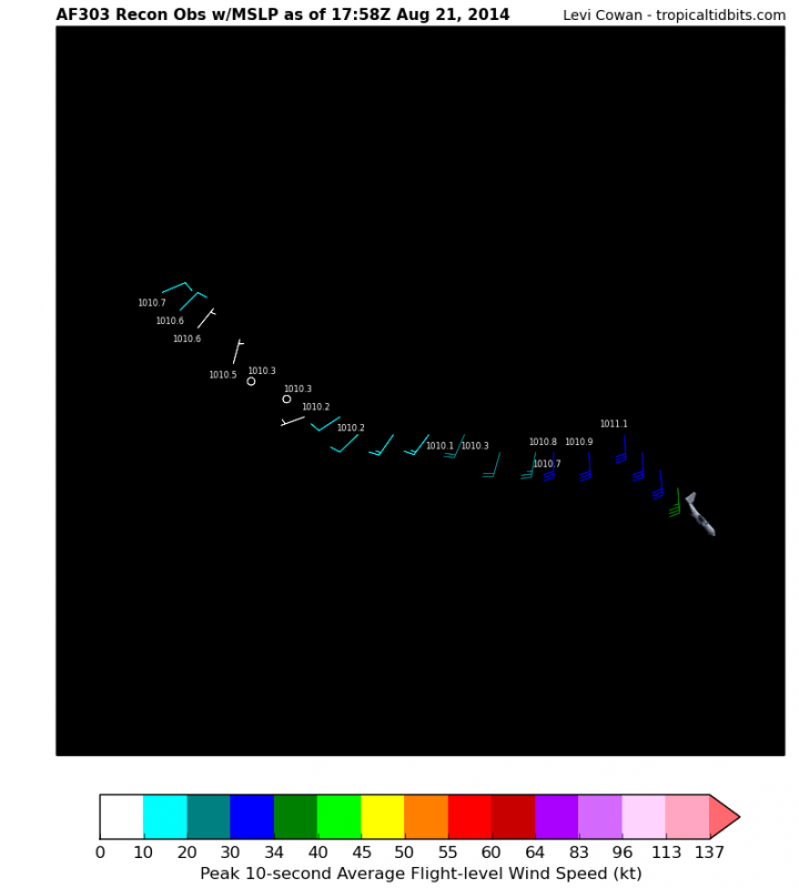
closely monitor the progress of this disturbance. An Air Force
Reserve Hurricane Hunter aircraft is currently investigating the
system.
* Formation chance through 48 hours...medium...50 percent.
* Formation chance through 5 days...high...70 percent.

$$
Forecaster Brennan
0 likes   

User avatar
Ntxw
Storm2k Moderator
Storm2k Moderator
Posts: 22785
Joined: Wed Oct 21, 2009 6:34 pm
Location: DFW, Texas

#411 Postby Ntxw » Thu Aug 21, 2014 12:54 pm

I think too much emphasis has been put on where 96L is going rather than where it is now which is the zone that 2014 has claimed victims with conditions. Once it left the moonsonal region its struggling, probably until it reaches the subtropics but will it be too late by then?
0 likes   
The above post and any post by Ntxw is NOT an official forecast and should not be used as such. It is just the opinion of the poster and may or may not be backed by sound meteorological data. It is NOT endorsed by any professional institution including Storm2k. For official information, please refer to NWS products.

  Help support Storm2K!
Help Support Storm2K

User avatar
Nimbus
Category 5
Category 5
Posts: 5300
Joined: Mon Jul 19, 2004 10:54 am

#412 Postby Nimbus » Thu Aug 21, 2014 12:57 pm

You can see the circulation around high pressure in the water vapor loop. The TUTT north of Hispaniola that has been providing light shear from the south is getting squeezed by the high over the Southeast CONUS. If that high was to bridge over 96L, the shear would drop and there would be a significant westerly shift in the track. Makes the forecast a little more difficult since the eventual ridge strength and timing of a second weakness have too many possible random outcomes.

Good test for the models though.
0 likes   

User avatar
NDG
S2K Supporter
S2K Supporter
Posts: 15446
Joined: Sun Jul 09, 2006 10:14 pm
Location: Orlando, FL

#413 Postby NDG » Thu Aug 21, 2014 1:05 pm

Ha, recon found a west wind near that weak LLC.
0 likes   

User avatar
NDG
S2K Supporter
S2K Supporter
Posts: 15446
Joined: Sun Jul 09, 2006 10:14 pm
Location: Orlando, FL

#414 Postby NDG » Thu Aug 21, 2014 1:07 pm

Pressure near 1010 mb.
0 likes   

User avatar
northjaxpro
S2K Supporter
S2K Supporter
Posts: 8900
Joined: Mon Sep 27, 2010 11:21 am
Location: Jacksonville, FL

#415 Postby northjaxpro » Thu Aug 21, 2014 1:09 pm

:uarrow: And they found that right in the area where that partially exposed LLC we observed on satellite .
0 likes   
NEVER, EVER SAY NEVER in the tropics and weather in general, and most importantly, with life itself!!

________________________________________________________________________________________

Fay 2008 Beryl 2012 Debby 2012 Colin 2016 Hermine 2016 Julia 2016 Matthew 2016 Irma 2017 Dorian 2019

User avatar
NDG
S2K Supporter
S2K Supporter
Posts: 15446
Joined: Sun Jul 09, 2006 10:14 pm
Location: Orlando, FL

Re: ATL: INVEST 96L - Discussion

#416 Postby NDG » Thu Aug 21, 2014 1:13 pm

A close up look at where they sampled the area where a weak LLC appears in vis satellite.

Image
0 likes   

User avatar
Weatherboy1
Category 5
Category 5
Posts: 1189
Age: 49
Joined: Mon Jul 05, 2004 1:50 pm
Location: Jupiter/Sarasota, FL

#417 Postby Weatherboy1 » Thu Aug 21, 2014 1:24 pm

In my opinion, we're really just 2-3 hours of persistent convection over that LLC away from this being declared a TD. Have to see if it can fire that up and battle off the modestly dry air in the vicinity right now.
0 likes   

User avatar
Weatherboy1
Category 5
Category 5
Posts: 1189
Age: 49
Joined: Mon Jul 05, 2004 1:50 pm
Location: Jupiter/Sarasota, FL

#418 Postby Weatherboy1 » Thu Aug 21, 2014 1:25 pm

I mean, you have model support for a system to develop to some degree ... you have relatively persistent (if sparse) convection unlike some of these "naked swirl" systems we've seen before ... and you have nice warm SSTs to work with. Maybe we finally get a declaration tonight?
0 likes   

User avatar
tropicwatch
Category 5
Category 5
Posts: 3383
Age: 61
Joined: Sat Jun 02, 2007 10:01 am
Location: Panama City Florida
Contact:

#419 Postby tropicwatch » Thu Aug 21, 2014 1:27 pm

Can anyone take over on Recon observations?
0 likes   
Tropicwatch


Agnes 72', Eloise 75, Elena 85', Kate 85', Charley 86', Florence 88', Beryl 94', Dean 95', Erin 95', Opal 95', Earl 98', Georges 98', Ivan 2004', Arlene 2005', Dennis 2005', Ida 2009' Debby 2012' Irma 2017' Michael 2018'

User avatar
gatorcane
S2K Supporter
S2K Supporter
Posts: 23691
Age: 47
Joined: Sun Mar 13, 2005 3:54 pm
Location: Boca Raton, FL

#420 Postby gatorcane » Thu Aug 21, 2014 1:28 pm

Nice 5-day graphic, what shape is that? :)

Image
0 likes   


Return to “2014”

Who is online

Users browsing this forum: No registered users and 3 guests