hawaiigirl wrote:oh great...
Where, in Hawaii, are you?
Moderator: S2k Moderators


hawaiigirl wrote:north shore Oahu


wxman57 wrote:hawaiigirl wrote:north shore Oahu
Wow! I might have to come over there as your personal meteorologist! Fortunately, if Iselle stays on-track, you won't see too much impact that far north. Probably sub-tropical storm-force winds (25-35 mph) with higher gusts on the North Shore. Just let me know and I'll fly over and monitor the beach for you.


Kingarabian wrote:I live in Honolulu. How bad do you think it'll get there?
WeatherGuesser wrote:Kingarabian wrote:I live in Honolulu. How bad do you think it'll get there?
Won't it get more or less shredded by Hawaii and Maui?
Yellow Evan wrote:Good news
EP, 09, 2014080518, , BEST, 0, 162N, 1399W, 95, 967, HU, 34, NEQ, 100, 90, 60, 80, 1011, 190, 15, 0, 20, E, 0, , 0, 0, ISELLE, D,
EP, 09, 2014080518, , BEST, 0, 162N, 1399W, 95, 967, HU, 50, NEQ, 50, 40, 40, 50, 1011, 190, 15, 0, 20, E, 0, , 0, 0, ISELLE, D,
EP, 09, 2014080518, , BEST, 0, 162N, 1399W, 95, 967, HU, 64, NEQ, 30, 25, 20, 25, 1011, 190, 15, 0, 20, E, 0, , 0, 0, ISELLE, D,


Kingarabian wrote:Yellow Evan wrote:Good news
EP, 09, 2014080518, , BEST, 0, 162N, 1399W, 95, 967, HU, 34, NEQ, 100, 90, 60, 80, 1011, 190, 15, 0, 20, E, 0, , 0, 0, ISELLE, D,
EP, 09, 2014080518, , BEST, 0, 162N, 1399W, 95, 967, HU, 50, NEQ, 50, 40, 40, 50, 1011, 190, 15, 0, 20, E, 0, , 0, 0, ISELLE, D,
EP, 09, 2014080518, , BEST, 0, 162N, 1399W, 95, 967, HU, 64, NEQ, 30, 25, 20, 25, 1011, 190, 15, 0, 20, E, 0, , 0, 0, ISELLE, D,
Yeah good call. Definitely lacks the deep convection usually associated with major hurricanes.
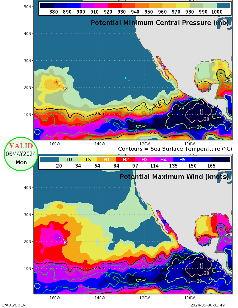
Anyways, I don't recall seeing so much warm water around Hawaii.
http://i.imgur.com/udaIM6C.gif
And looks like it will escape into an area with non existent shear near its center before the great Hawaiian shear kicks in.
http://i.imgur.com/hVU9fnt.png
Yellow Evan wrote:
Really has 12 hours left to weaken
TIME (HR) 0 6 12 18 24 36 48 60 72 84 96 108 120
V (KT) NO LAND 95 86 77 69 64 55 52 46 42 39 37 34 32
V (KT) LAND 95 86 77 69 64 55 52 46 42 39 37 35 33
V (KT) LGE mod 95 87 80 74 69 62 57 54 50 47 45 42 39
Storm Type TROP TROP TROP TROP TROP TROP TROP TROP TROP TROP TROP TROP TROP
SHEAR (KT) 12 11 14 6 3 5 3 8 13 14 17 19 30
SHEAR ADJ (KT) 5 2 -1 -2 1 1 0 0 0 6 2 0 -5
SHEAR DIR 233 199 201 207 72 92 243 289 287 298 322 338 343
SST (C) 26.1 26.1 26.2 26.1 25.9 25.9 26.1
The Great Hawaiian Shear does not kick in till after Hawaii this time around.
Kingarabian wrote:wxman57 wrote:hawaiigirl wrote:north shore Oahu
Wow! I might have to come over there as your personal meteorologist! Fortunately, if Iselle stays on-track, you won't see too much impact that far north. Probably sub-tropical storm-force winds (25-35 mph) with higher gusts on the North Shore. Just let me know and I'll fly over and monitor the beach for you.
I live in Honolulu. How bad do you think it'll get there?


wxman57 wrote:Kingarabian wrote:wxman57 wrote:
Wow! I might have to come over there as your personal meteorologist! Fortunately, if Iselle stays on-track, you won't see too much impact that far north. Probably sub-tropical storm-force winds (25-35 mph) with higher gusts on the North Shore. Just let me know and I'll fly over and monitor the beach for you.
I live in Honolulu. How bad do you think it'll get there?
Low-end tropical storm force sustained winds at most (35-45 mph with 50-55 mph gusts). Peak wind just before sunrise on Friday. Generally, winds will be less than TS force.
somethingfunny wrote:I want to mention that I think Iselle is most likely going to repeat what Flossie did but I also want to mention the disclaimer in my signature.
somethingfunny wrote:I want to mention that I think Iselle is most likely going to repeat what Flossie did but I also want to mention the disclaimer in my signature.
Users browsing this forum: No registered users and 1 guest

