WPAC: GENEVIEVE - Post-Tropical

Moderator: S2k Moderators

Message
Author
euro6208

Re:

#121 Postby euro6208 » Sat Aug 02, 2014 11:13 am

xtyphooncyclonex wrote:06z GFS has this deepening to 943 mb over the Western Pacific. :eek: :eek:


I saw that too...The West Pacific is the hot spot...

Question: Will the total ACE for Genevieve be counted towards the EPAC even though this will peak in the WPAC?
0 likes   

dexterlabio
Category 5
Category 5
Posts: 3468
Joined: Sat Oct 24, 2009 11:50 pm

Re: CPAC: GENEVIEVE - Tropical Depression

#122 Postby dexterlabio » Sat Aug 02, 2014 11:23 am

very interesting if we will see Typhoon Genevieve in the Western Pacific. :lol:


Are there tropical cyclones from the EPAC that made it to the WPAC keeping the same name? We had some CPAC to WPAC crossover TC's last year, the most notable for me though was Hurricane/Typhoon Ioke in 2006...but I don't know if we had an EPAC to WPAC crossover storm...
0 likes   
Personal Forecast Disclaimer:
The posts in this forum are NOT official forecast and should not be used as such. They are just the opinion of the poster and may or may not be backed by sound meteorological data. They are NOT endorsed by any professional institution or storm2k.org. For official information, please refer to the NHC and NWS products.

User avatar
xtyphooncyclonex
Category 5
Category 5
Posts: 3861
Age: 23
Joined: Sat Dec 08, 2012 9:07 am
Location: Cebu City
Contact:

Re: CPAC: GENEVIEVE - Tropical Depression

#123 Postby xtyphooncyclonex » Sat Aug 02, 2014 11:26 am

dexterlabio wrote:very interesting if we will see Typhoon Genevieve in the Western Pacific. :lol:


Are there tropical cyclones from the EPAC that made it to the WPAC keeping the same name? We had some CPAC to WPAC crossover TC's last year, the most notable for me though was Hurricane/Typhoon Ioke in 2006...but I don't know if we had an EPAC to WPAC crossover storm...

Typhoon John in 1994 entered the WPAC as a category 3 typhoon, after weakening from category 5 status over the CPAC/EPAC.
0 likes   
REMINDER: My opinions that I, or any other NON Pro-Met in this forum, are unofficial. Please do not take my opinions as an official forecast and warning. I am NOT a meteorologist. Following my forecasts blindly may lead to false alarm, danger and risk if official forecasts from agencies are ignored.

User avatar
galaxy401
Category 5
Category 5
Posts: 2419
Age: 30
Joined: Sat Aug 25, 2012 9:04 pm
Location: Casa Grande, Arizona

#124 Postby galaxy401 » Sat Aug 02, 2014 11:29 am

Well this storm is a trooper. I wonder how far this storm can go.
0 likes   
Got my eyes on moving right into Hurricane Alley: Florida.

User avatar
cycloneye
Admin
Admin
Posts: 145286
Age: 68
Joined: Thu Oct 10, 2002 10:54 am
Location: San Juan, Puerto Rico

Re: CPAC: GENEVIEVE - Tropical Depression

#125 Postby cycloneye » Sat Aug 02, 2014 11:29 am

TROPICAL DEPRESSION GENEVIEVE DISCUSSION NUMBER 22
NWS CENTRAL PACIFIC HURRICANE CENTER HONOLULU HI EP072014
500 AM HST SAT AUG 02 201

A BURST OF DEEP CONVECTION HAS BROUGHT GENEVIEVE BACK TO LIFE AS A
TROPICAL DEPRESSION FOR A SECOND TIME IN THE CENTRAL NORTH PACIFIC.
A 0719Z ASCAT SCATTEROMETER PASS CONFIRMED THAT A LOW-LEVEL
CIRCULATION CENTER /LLCC/ WAS PRESENT AS THESE THUNDERSTORMS WERE
BECOMING INVIGORATED. THE MOST RECENT INFRARED SATELLITE IMAGERY
SHOWS NOT ONLY THAT REINVIGORATED GENEVIEVE HAS DEVELOPED A MUCH
IMPROVED UPPER-LEVEL OUTFLOW PATTERN...BUT ALSO IT APPEARS TO BE
TAPPING INTO DEEP TROPICAL MOISTURE TO THE SOUTHEAST OF THE SYSTEM.
THE LATEST ESTIMATES OF VERTICAL WIND SHEAR ALSO SEEM TO INDICATE
THAT THE ENVIRONMENT IS CONDUCIVE FOR THE SYSTEM TO REMAIN VIABLE IN
THE NEAR-TERM. THE CURRENT INTENSITY ESTIMATES FROM THE SATELLITE
FIX AGENCIES SHOW T NUMBERS OF 2.0 AT PHFO AND SAB...WHILE JTWC HAS
A 1.5. IN ADDITION TO THESE DVORAK FIXES...THE 0719Z ASCAT PASS
SHOWED A BROAD SWATH OF 30 KT WINDS JUST NORTH OF THE LLCC.
THEREFORE...THIS INITIAL ADVISORY WILL INDICATE AN INTENSITY OF 30
KT...WITH A CURRENT MOTION OF 265 DEGREES / 09 KT.

GENEVIEVE IS MOVING SOUTH OF A SUBTROPICAL RIDGE...WHICH WILL LIKELY
REMAIN IN PLACE FOR THE NEXT FEW DAYS. AS A RESULT... DYNAMICAL AND
CONSENSUS TRACK GUIDANCE APPEAR TO BE TIGHTLY CLUSTERED FOR THE NEXT
2 TO 3 DAYS. THESE AIDS SHOW A SLIGHT TURN TOWARD THE WEST SOUTHWEST
DURING THIS TIME PERIOD AT A SLIGHTLY FASTER FORWARD SPEED. THE
CURRENT FORECAST TRACK IS SLIGHTLY TO THE RIGHT OF MOST OF THESE
AIDS THROUGH THE NEXT 72 HOURS. AFTER THAT...THE FORECAST IS CLOSE
TO THE GUIDANCE ON DAYS 4 AND 5.

MORE PROBLEMATIC IS THE INTENSITY FORECAST...SINCE THERE IS A CHANCE
GENEVIEVE MAY ALREADY BE A TROPICAL STORM. ASSUMING IT IS A TROPICAL
DEPRESSION...THE FORECAST MODELS...SUCH AS SHIPS...APPEAR TO
GRADUALLY INTENSIFY THE SYSTEM THROUGH THE NEXT 48 TO 72 HOURS...
SINCE VERTICAL WIND SHEAR IS ASSUMED TO BE LOW AND THE SSTS ARE
GREATER THAN 27C ALONG THE FORECAST TRACK. THEREFORE...THE CURRENT
FORECAST INDICATES GENEVIEVE MAY BECOME A TROPICAL STORM LATER TODAY
OR TONIGHT. AFTER THAT SOME ADDITIONAL SLIGHT INTENSIFICATION IS
FORECAST.

FORECAST POSITIONS AND MAX WINDS

INIT 02/1500Z 11.9N 155.7W 30 KT 35 MPH
12H 03/0000Z 11.6N 157.5W 35 KT 40 MPH
24H 03/1200Z 11.2N 159.9W 35 KT 40 MPH
36H 04/0000Z 10.8N 162.2W 40 KT 45 MPH
48H 04/1200Z 11.0N 164.4W 45 KT 50 MPH
72H 05/1200Z 12.5N 169.9W 45 KT 50 MPH
96H 06/1200Z 14.5N 175.5W 45 KT 50 MPH
120H 07/1200Z 16.5N 178.0E 45 KT 50 MPH

$$
FORECASTER HOUSTON
0 likes   
Visit the Caribbean-Central America Weather Thread where you can find at first post web cams,radars
and observations from Caribbean basin members Click Here

dexterlabio
Category 5
Category 5
Posts: 3468
Joined: Sat Oct 24, 2009 11:50 pm

Re: CPAC: GENEVIEVE - Tropical Depression

#126 Postby dexterlabio » Sat Aug 02, 2014 11:31 am

Ok I just got the answer to my question...the last EPAC tropical cyclone that reached WPAC is John in 1994. It's a very rare event seeing an EPAC storm crossing the WPAC...
0 likes   
Personal Forecast Disclaimer:
The posts in this forum are NOT official forecast and should not be used as such. They are just the opinion of the poster and may or may not be backed by sound meteorological data. They are NOT endorsed by any professional institution or storm2k.org. For official information, please refer to the NHC and NWS products.

User avatar
Yellow Evan
Professional-Met
Professional-Met
Posts: 16143
Age: 27
Joined: Fri Jul 15, 2011 12:48 pm
Location: Henderson, Nevada/Honolulu, HI
Contact:

Re: CPAC: GENEVIEVE - Tropical Depression

#127 Postby Yellow Evan » Sat Aug 02, 2014 3:21 pm

dexterlabio wrote:Ok I just got the answer to my question...the last EPAC tropical cyclone that reached WPAC is John in 1994. It's a very rare event seeing an EPAC storm crossing the WPAC...


Jimena 03.

Dora 99.

If you wanna be technical, EPAC arguably goes to the dateline.
0 likes   

User avatar
galaxy401
Category 5
Category 5
Posts: 2419
Age: 30
Joined: Sat Aug 25, 2012 9:04 pm
Location: Casa Grande, Arizona

Re: CPAC: GENEVIEVE - Tropical Storm

#128 Postby galaxy401 » Sat Aug 02, 2014 4:46 pm

Tropical Storm now.

TROPICAL STORM GENEVIEVE DISCUSSION NUMBER 23
NWS CENTRAL PACIFIC HURRICANE CENTER HONOLULU HI EP072014
1100 AM HST SAT AUG 02 2014

DEEP CONVECTION CONTINUES NEAR THE CENTER OF GENEVIEVE AS IT MOVES
TOWARD THE WEST-SOUTHWEST FAR SOUTH OF THE MAIN HAWAIIAN ISLANDS.
THE LATEST INTENSITY ESTIMATES FROM SATELLITE FIX AGENCIES SHOW T
NUMBERS OF 2.0 FROM SAB AND JTWC AND 2.5 FROM PHFO. BASED ON ITS
CURRENT SATELLITE REPRESENTATION...GENEVIEVE HAS BEEN UPGRADED TO A
TROPICAL STORM ONCE AGAIN. UW-CIMSS INDICATES VERY LITTLE SHEAR OVER
THE SYSTEM WHILE SHIPS INDICATES ABOUT 7 KT.

GENEVIEVE IS MOVING ALONG SOUTH OF A SUBTROPICAL RIDGE WHICH IS
EXPECTED TO REMAIN IN PLACE FOR THE NEXT COUPLE OF DAYS. DURING DAYS
3 THROUGH 5...GENEVIEVE IS EXPECTED TO GAIN LATITUDE AS IT WILL BE
NEAR THE WEST END OF THE SUBTROPICAL RIDGE. MODEL GUIDANCE IS
TIGHTLY CLUSTERED WITH A GENERAL WEST TO WEST-SOUTHWEST TRACK
THROUGH ABOUT 36 HOURS WITH A GRADUAL TURN TOWARD THE WEST-NORTHWEST
THEREAFTER. THE CURRENT FORECAST TRACK HAS BEEN ADJUSTED SLIGHTLY TO
THE LEFT OF THE PREVIOUS FORECAST TRACK BUT FOLLOWS DOWN THE CENTER
OF GUIDANCE ENVELOPE. A SLIGHT INCREASE IN FORWARD SPEED IS ALSO
EXPECTED DURING THE NEXT FEW DAYS WHICH ALSO FOLLOWS ALONG WITH
MODEL GUIDANCE.

THE VAST MAJORITY OF INTENSITY GUIDANCE INDICATE THAT GENEVIEVE WILL
CONTINUE TO SLOWLY STRENGTHEN OVER THE NEXT SEVERAL DAYS. SHIPS
GUIDANCE INDICATES A LITTLE BIT OF EASTERLY SHEAR WILL BE NEAR THE
SYSTEM FOR THE NEXT DAY OR SO BEFORE RELAXING IN ABOUT 48 HOURS. SST
VALUES WILL BE NEAR OR ABOVE 28C ALONG THE ENTIRE FORECAST TRACK.
THUS THE CURRENT INTENSITY FORECAST FOLLOWS MOST MODEL TRENDS AND
SLOWLY STRENGTHENS GENEVIEVE OVER THE NEXT FEW DAYS WITH A PEAK
INTENSITY OF ABOUT 60 KT AROUND DAYS 4 AND 5.

FORECAST POSITIONS AND MAX WINDS

INIT 02/2100Z 10.6N 157.8W 35 KT 40 MPH
12H 03/0600Z 10.1N 159.8W 40 KT 45 MPH
24H 03/1800Z 9.6N 162.1W 45 KT 50 MPH
36H 04/0600Z 9.2N 164.4W 45 KT 50 MPH
48H 04/1800Z 9.4N 166.8W 50 KT 60 MPH
72H 05/1800Z 11.0N 172.2W 55 KT 65 MPH
96H 06/1800Z 12.9N 177.8W 60 KT 70 MPH
120H 07/1800Z 14.8N 176.7E 60 KT 70 MPH

$$
FORECASTER BURKE

Could reach hurricane/typhoon strength. This storm interests me more than Bertha and even Iselle.
0 likes   
Got my eyes on moving right into Hurricane Alley: Florida.

CrazyC83
Professional-Met
Professional-Met
Posts: 34002
Joined: Tue Mar 07, 2006 11:57 pm
Location: Deep South, for the first time!

Re: Re:

#129 Postby CrazyC83 » Sat Aug 02, 2014 6:13 pm

euro6208 wrote:
xtyphooncyclonex wrote:06z GFS has this deepening to 943 mb over the Western Pacific. :eek: :eek:


I saw that too...The West Pacific is the hot spot...

Question: Will the total ACE for Genevieve be counted towards the EPAC even though this will peak in the WPAC?


No it would not count towards the EPAC once past 180.
0 likes   

User avatar
xtyphooncyclonex
Category 5
Category 5
Posts: 3861
Age: 23
Joined: Sat Dec 08, 2012 9:07 am
Location: Cebu City
Contact:

#130 Postby xtyphooncyclonex » Sat Aug 02, 2014 7:42 pm

If this would cross the IDL, it may be a typhoon, as the SSTs are currently warm and the shear is also very favorably low.
0 likes   
REMINDER: My opinions that I, or any other NON Pro-Met in this forum, are unofficial. Please do not take my opinions as an official forecast and warning. I am NOT a meteorologist. Following my forecasts blindly may lead to false alarm, danger and risk if official forecasts from agencies are ignored.

User avatar
xtyphooncyclonex
Category 5
Category 5
Posts: 3861
Age: 23
Joined: Sat Dec 08, 2012 9:07 am
Location: Cebu City
Contact:

#131 Postby xtyphooncyclonex » Sat Aug 02, 2014 7:45 pm

WOW!! STEADY INTENSIFICATION over the WPAC, making it stronger than how it was in the EPAC. :eek:

INIT 02/2100Z 10.6N 157.8W 35 KT 40 MPH
12H 03/0600Z 10.1N 159.8W 40 KT 45 MPH
24H 03/1800Z 9.6N 162.1W 45 KT 50 MPH
36H 04/0600Z 9.2N 164.4W 45 KT 50 MPH
48H 04/1800Z 9.4N 166.8W 50 KT 60 MPH
72H 05/1800Z 11.0N 172.2W 55 KT 65 MPH
96H 06/1800Z 12.9N 177.8W 60 KT 70 MPH
120H 07/1800Z 14.8N 176.7E 60 KT 70 MPH

Hope it would not be like Pewa last year. :lol: :lol: :lol: :lol:
0 likes   
REMINDER: My opinions that I, or any other NON Pro-Met in this forum, are unofficial. Please do not take my opinions as an official forecast and warning. I am NOT a meteorologist. Following my forecasts blindly may lead to false alarm, danger and risk if official forecasts from agencies are ignored.

User avatar
Yellow Evan
Professional-Met
Professional-Met
Posts: 16143
Age: 27
Joined: Fri Jul 15, 2011 12:48 pm
Location: Henderson, Nevada/Honolulu, HI
Contact:

Re:

#132 Postby Yellow Evan » Sat Aug 02, 2014 7:47 pm

xtyphooncyclonex wrote:If this would cross the IDL, it may be a typhoon, as the SSTs are currently warm and the shear is also very favorably low.


Right now, there is some shear actually. Should decrease though.
0 likes   

supercane4867
Category 5
Category 5
Posts: 4966
Joined: Wed Nov 14, 2012 10:43 am

Re: CPAC: GENEVIEVE - Tropical Depression

#133 Postby supercane4867 » Sat Aug 02, 2014 8:02 pm

HWRF looks awesome

Image
0 likes   

User avatar
Yellow Evan
Professional-Met
Professional-Met
Posts: 16143
Age: 27
Joined: Fri Jul 15, 2011 12:48 pm
Location: Henderson, Nevada/Honolulu, HI
Contact:

Re: CPAC: GENEVIEVE - Tropical Depression

#134 Postby Yellow Evan » Sat Aug 02, 2014 8:20 pm

supercane4867 wrote:HWRF looks awesome

Image


HWRF does not normally run past the dateline, so they tend to get super aggressive with these types of storms.
0 likes   

User avatar
galaxy401
Category 5
Category 5
Posts: 2419
Age: 30
Joined: Sat Aug 25, 2012 9:04 pm
Location: Casa Grande, Arizona

#135 Postby galaxy401 » Sat Aug 02, 2014 9:33 pm

Just a reminder to the mods if they can change the title since Genevieve is a tropical storm now.
0 likes   
Got my eyes on moving right into Hurricane Alley: Florida.

CrazyC83
Professional-Met
Professional-Met
Posts: 34002
Joined: Tue Mar 07, 2006 11:57 pm
Location: Deep South, for the first time!

#136 Postby CrazyC83 » Sat Aug 02, 2014 9:44 pm

I remember with Ioke the HWRF and GFDL were forecasting a hyper-intense, Haiyan-like storm once over the dateline, due to physical limitations...
0 likes   

User avatar
Yellow Evan
Professional-Met
Professional-Met
Posts: 16143
Age: 27
Joined: Fri Jul 15, 2011 12:48 pm
Location: Henderson, Nevada/Honolulu, HI
Contact:

Re:

#137 Postby Yellow Evan » Sat Aug 02, 2014 9:49 pm

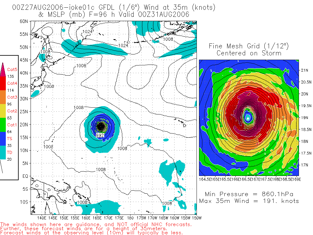
CrazyC83 wrote:I remember with Ioke the HWRF and GFDL were forecasting a hyper-intense, Haiyan-like storm once over the dateline, due to physical limitations...


HWRF wasn't around in 2006.

Image

Here was one GFDL run from Ioke.
0 likes   

dexterlabio
Category 5
Category 5
Posts: 3468
Joined: Sat Oct 24, 2009 11:50 pm

Re: CPAC: GENEVIEVE - Tropical Depression

#138 Postby dexterlabio » Sat Aug 02, 2014 9:59 pm

Yellow Evan wrote:
Jimena 03.

Dora 99.

If you wanna be technical, EPAC arguably goes to the dateline.


JMA didn't issue warnings on Jimena and treated it as a degenerated low so I didn't count it. JTWC issued warnings on Jimena as a weak TS or TD though.
0 likes   
Personal Forecast Disclaimer:
The posts in this forum are NOT official forecast and should not be used as such. They are just the opinion of the poster and may or may not be backed by sound meteorological data. They are NOT endorsed by any professional institution or storm2k.org. For official information, please refer to the NHC and NWS products.

hurricanes1234
Category 5
Category 5
Posts: 2907
Joined: Sat Jul 28, 2012 6:19 pm
Location: Trinidad and Tobago

#139 Postby hurricanes1234 » Sat Aug 02, 2014 10:04 pm

Back down to a depression.

Tropical Depression GENEVIEVE Advisory Number 24
Issued at 500 PM HST SAT AUG 02 2014
SUMMARY OF 500 PM HST...0300 UTC...INFORMATION
----------------------------------------------
Location: 9.8N 158.8W
ABOUT 795 MI...1280 KM S OF HONOLULU HAWAII
ABOUT 860 MI...1390 KM ESE OF JOHNSTON ISLAND
Maximum sustained winds: 35 MPH...55 KM/H
Present movement: WSW or 255 degrees AT 16 MPH...26 KM/H
Minimum central pressure: 1007 MB...29.74 INCHES
0 likes   
PLEASE NOTE: With the exception of information from weather agencies that I may copy and paste here, my posts will NEVER be official, since I am NOT a meteorologist. They are solely my amateur opinion, and may or may not be accurate. Therefore, please DO NOT use them as official details, particularly when making important decisions. Thank you.

User avatar
galaxy401
Category 5
Category 5
Posts: 2419
Age: 30
Joined: Sat Aug 25, 2012 9:04 pm
Location: Casa Grande, Arizona

#140 Postby galaxy401 » Sat Aug 02, 2014 10:05 pm

Well so much for requesting to change the title to a tropical storm. :lol:

Can this storm just make up its mind?
0 likes   
Got my eyes on moving right into Hurricane Alley: Florida.


Return to “2014”

Who is online

Users browsing this forum: No registered users and 3 guests