

Texas Summer - 2014
Moderator: S2k Moderators
Forum rules

The posts in this forum are NOT official forecast and should not be used as such. They are just the opinion of the poster and may or may not be backed by sound meteorological data. They are NOT endorsed by any professional institution or STORM2K.
And as ntxw commented yesterday the FFW should add counties further south, NWS FWD has added counties all the way down to Waco in the flash flood watch.
0 likes
The above post and any post by dhweather is NOT an official forecast and should not be used as such. It is just the opinion of the poster and may or may not be backed by sound meteorological data. It is NOT endorsed by any professional institution including storm2k.org. For official information, please refer to NWS products.
AREA FORECAST DISCUSSION
NATIONAL WEATHER SERVICE FORT WORTH TX
1033 AM CDT THU JUL 17 2014
.UPDATE...
THE HEAVY RAIN EVENT CONTINUES TO EVOLVE ACROSS NORTH TEXAS THIS
MORNING. THE MAIN PLAYERS IN THIS EVENT ARE (1) AN UPPER LEVEL
SHORT WAVE CURRENTLY MOVING ACROSS THE TEXAS PANHANDLE AND
SOUTHWEST OKLAHOMA (2)A NEARLY STATIONARY SURFACE FRONT CURRENTLY
NEAR THE INTERSTATE 20 CORRIDOR (3) A SURGE OF LOW LEVEL MOISTURE
FROM THE SOUTH AND (4) AN EASTWARD MOVING MESOSCALE CONVECTIVE VORTICITY.
WE EXPECT PERIODS OF RAIN AND THUNDERSTORMS TO CONTINUE THROUGH
THE AFTERNOON AS THE SHORT MOVES SOUTHEAST. AS THE UPPER TROUGH
AXIS PASSES EAST OF THE REGION TONIGHT THE FRONT WILL MOVE
SOUTHWARD. ONCE THIS HAPPENS...RAIN CHANCES WILL DECREASE FROM
NORTHWEST TO SOUTHEAST.
FOR THIS UPDATE...WE HAVE DECIDED TO EXPAND THE FLASH FLOOD WATCH
A COUPLE OF ROWS OF COUNTIES TO THE SOUTH AND WEST WHERE THE BEST
MOISTURE RESIDES AND MESOSCALE LIFT WILL BE ENHANCED BY AN
EASTWARD MOVING MCV...CURRENTLY ROTATING ACROSS COMANCHE COUNTY.
ADDITIONAL RAINFALL AMOUNTS OF 2 INCHES OR MORE ARE LIKELY IN THE
WATCH AREA WITH SOME MUCH HIGHER AMOUNTS POSSIBLE.
NO OTHER MAJOR CHANGES TO THE FORECAST AT THIS TIME.
0 likes
The above post and any post by dhweather is NOT an official forecast and should not be used as such. It is just the opinion of the poster and may or may not be backed by sound meteorological data. It is NOT endorsed by any professional institution including storm2k.org. For official information, please refer to NWS products.

Re: Texas Summer - 2014
68F at noon on a mid July day at DFW! Enjoy while you can, soak it in, make the most of it!
0 likes
The above post and any post by Ntxw is NOT an official forecast and should not be used as such. It is just the opinion of the poster and may or may not be backed by sound meteorological data. It is NOT endorsed by any professional institution including Storm2k. For official information, please refer to NWS products.
Help support Storm2K!
-
TeamPlayersBlue

- Category 5

- Posts: 3531
- Joined: Tue Feb 02, 2010 1:44 am
- Location: Denver/Applewood, CO
Cell coming through SL right now is making it sound like a warzone outside. Couch is shaking.
0 likes
Personal Forecast Disclaimer:
The posts in this forum are NOT official forecast and should not be used as such. They are just the opinion of the poster and may or may not be backed by sound meteorological data. They are NOT endorsed by any professional institution or storm2k.org. For official information, please refer to the NHC and NWS products.
The posts in this forum are NOT official forecast and should not be used as such. They are just the opinion of the poster and may or may not be backed by sound meteorological data. They are NOT endorsed by any professional institution or storm2k.org. For official information, please refer to the NHC and NWS products.
-
srainhoutx

- S2K Supporter

- Posts: 6919
- Age: 68
- Joined: Sun Jan 14, 2007 11:34 am
- Location: Haywood County, NC
- Contact:
Re: Texas Summer - 2014
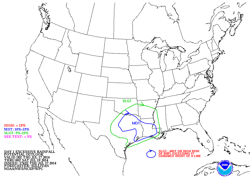
The Weather Prediction Center places a rather large Moderate Risk for Excessive Rainfall across portions of NE/E/SE Texas as well as much of Southern Louisiana.
0 likes
Carla/Alicia/Jerry(In The Eye)/Michelle/Charley/Ivan/Dennis/Katrina/Rita/Wilma/Ike/Harvey
Member: National Weather Association
Wx Infinity Forums
http://wxinfinity.com/index.php
Facebook.com/WeatherInfinity
Twitter @WeatherInfinity
Member: National Weather Association
Wx Infinity Forums
http://wxinfinity.com/index.php
Facebook.com/WeatherInfinity
Twitter @WeatherInfinity
-
horselattitudesfarm

- Category 1

- Posts: 315
- Joined: Thu Jul 16, 2009 5:55 pm
- Location: Asheville, NC (formerly from Dallas, TX)
Re: Texas Summer - 2014
Looking like North Texas' rainfall might be a done deal so whoever got the rain, feel lucky. As for the rest, I would be prepared for not much more fanfare unless you live south and southeast of the metroplex. This is according to the following discussion from the DFW NWS:
"DISCUSSION...
AFTER A VERY WET DAY ACROSS NORTH TEXAS WITH SOME IMPRESSIVE
RAINFALL TOTALS...THE ATMOSPHERE WILL BEGIN TO DRY OUT THIS
EVENING WITH INCREASING LARGE SCALE SUBSIDENCE BEHIND A DEPARTING
UPPER LEVEL SHORT WAVE. A BOUNDARY WILL REMAIN DRAPED ACROSS THE
REGION AND WILL CONTINUE TO BE A FOCUS FOR SHOWERS AND
THUNDERSTORMS THROUGH THE NIGHT WITH THE BEST STORM CHANCES IN THE
SOUTHEAST ZONES IN THE WARM SECTOR. WE WILL CONTINUE THE FLASH
FLOOD WATCH FOR LOCATIONS ALONG AND SOUTHEAST OF A LINE FROM
BONHAM TO DALLAS TO GOLDTHWAITE. HOWEVER...THE NORTHERN LOCATIONS
OF THE WATCH ARE BEING LEFT IN ONLY AS A PRECAUTION DUE TO THE
OUTSIDE CHANCE THAT MESOSCALE LIFT OVER THE BOUNDARY EARLY THIS
EVENING CAN OVERCOME THE INCREASING LARGE SCALE SUBSIDENCE. SOME
IF NOT ALL OF THE FLASH FLOOD WATCH WILL LIKELY NEED TO BE
REMOVED LATER THIS EVENING.
THE UPPER TROUGH AXIS WILL MOVE EAST OF NORTH TEXAS ON FRIDAY AND
ALLOW A COLD FRONT TO MOVE INTO THE REGION. A FEW SHOWERS OR
STORMS MAY ACCOMPANY THE COLD FRONT ON FRIDAY...BUT THE BEST
STORM CHANCES WILL REMAIN TO THE EAST AND SOUTHEAST OF NORTH TEXAS.
THE COMBINATION OF COLD AIR ADVECTION AND ABUNDANT CLOUD COVER
WILL KEEP TEMPS WELL BELOW NORMAL ON FRIDAY WITH HIGHS GENERALLY
IN THE 80S. FRIDAY NIGHT WILL ALSO BE COOL FOR MID JULY WITH LOWS
FROM THE UPPER 60S IN THE NORTH TO THE MIDDLE 70S IN THE SOUTH.
THE COLD FRONT WILL BEGIN TO LIFT NORTH AGAIN ON SATURDAY DUE TO
ZONAL FLOW IN THE WEST AND SURFACE LEE TROUGHING ACROSS THE
NORTHERN AND CENTRAL HIGH PLAINS. A FEW SHOWERS AND THUNDERSTORMS
WILL BE POSSIBLE ACROSS THE EASTERN ZONES WHERE THE FRONT WILL
LINGER THE LONGEST. OTHERWISE...SATURDAY WILL SEE DECREASING
CLOUDS AND WARMER TEMPERATURES.
UPPER LEVEL HIGH PRESSURE WILL BEGIN TO BUILD OVER THE WESTERN
HALF OF THE CONUS LATE IN THE WEEKEND THROUGH THE MIDDLE OF NEXT
WEEK. NORTH TEXAS WILL REMAIN ON THE EASTERN EDGE OF THE RIDGE AND
MAY SEE SOME LOW SHOWER/STORM CHANCES...MAINLY TUESDAY AND
WEDNESDAY. EXPECT TEMPERATURES TO RETURN CLOSER TO SEASONAL
NORMALS SUNDAY THROUGH WEDNESDAY WITH HIGHS IN THE 90S AND LOWS IN THE
70S. THE RECENT RAINFALL AND POSITION OF THE RIDGE SHOULD KEEP
TEMPERATURES FROM WARMING MUCH ABOVE SEASONAL NORMALS THROUGH NEXT
WEEK"
0 likes
-
South Texas Storms

- Professional-Met

- Posts: 4259
- Joined: Thu Jun 24, 2010 12:28 am
- Location: Houston, TX
Re: Texas Summer - 2014
Showers and thunderstorms are currently developing across the Hill Country and are slowly moving southeast. These storms could make it to Austin and San Antonio later this evening.
0 likes
Anyone notice DFW's high temperature today was 79F? And that was just past midnight. The actual "daytime" high thus far today has been 72F. Back to back July's with a day that did not crack 80F
0 likes
The above post and any post by Ntxw is NOT an official forecast and should not be used as such. It is just the opinion of the poster and may or may not be backed by sound meteorological data. It is NOT endorsed by any professional institution including Storm2k. For official information, please refer to NWS products.
Help support Storm2K!
Help support Storm2K!
-
TeamPlayersBlue
- Category 5
- Posts: 3531
- Joined: Tue Feb 02, 2010 1:44 am
- Location: Denver/Applewood, CO
Flood watches put up already for SE Texas. Eeek.
0 likes
Personal Forecast Disclaimer:
The posts in this forum are NOT official forecast and should not be used as such. They are just the opinion of the poster and may or may not be backed by sound meteorological data. They are NOT endorsed by any professional institution or storm2k.org. For official information, please refer to the NHC and NWS products.
The posts in this forum are NOT official forecast and should not be used as such. They are just the opinion of the poster and may or may not be backed by sound meteorological data. They are NOT endorsed by any professional institution or storm2k.org. For official information, please refer to the NHC and NWS products.
-
weatherdude1108
- Category 5
- Posts: 4228
- Joined: Tue Dec 13, 2011 1:04 pm
- Location: Northwest Austin/Cedar Park, TX
Heavy rain here at Weatherdude Center. Stuff just popped up in the last 15 minutes.
Popped up on my phone:
"FLOOD ADVISORY
NATIONAL WEATHER SERVICE AUSTIN/SAN ANTONIO TX
1022 PM CDT THU JUL 17 2014
TRAVIS-WILLIAMSON-
1022 PM CDT THU JUL 17 2014
THE NATIONAL WEATHER SERVICE IN AUSTIN SAN ANTONIO HAS ISSUED AN
* URBAN AND SMALL STREAM FLOOD ADVISORY FOR...
SOUTHERN WILLIAMSON COUNTY...
TRAVIS COUNTY...
* UNTIL 1230 AM CDT
* AT 1017 PM CDT...NATIONAL WEATHER SERVICE METEOROLOGISTS HAVE
DETECTED THUNDERSTORMS WITH HEAVY RAINFALL ACROSS THE ADVISORY
AREA. DOPPLER RADAR ESTIMATED UP TO 1.5 INCHES OF RAIN HAS FALLEN
OVER SOUTHERN WILLIAMSON AS WELL AS CENTRAL AND EASTERN TRAVIS
COUNTIES. THIS INCLUDES THE CITIES OF AUSTIN...PFLUGERVILLE AND
ROUND ROCK.
* RUNOFF FROM THIS EXCESSIVE RAINFALL WILL CAUSE MINOR FLOODING TO
OCCUR...ESPECIALLY ALONG SMALL STREAMS AND NEAR LOW WATER
CROSSINGS. SOME LOCATIONS THAT WILL EXPERIENCE MINOR FLOODING
INCLUDE...ANDERSON MILL...AUSTIN BERGSTROM INTERNATIONAL
AIRPORT...CEDAR PARK...PFLUGERVILLE...ROUND ROCK...TANGLEWOOD
FOREST...BEE CAVE...COUPLAND AND HUTTO.
PRECAUTIONARY/PREPAREDNESS ACTIONS...
AN ADDITIONAL 1 TO 2 INCHES OF RAINFALL ARE STILL POSSIBLE IN THE
ADVISORY AREA THIS EVENING AS ADDITIONAL SHOWERS AND THUNDERSTORMS
MOVE ACROSS WILLIAMSON AND TRAVIS COUNTIES.
EXCESSIVE RUNOFF FROM THIS STORM WILL CAUSE MINOR FLOODING OF SMALL
CREEKS AND STREAMS...URBAN AREAS...HIGHWAYS...STREETS AND UNDERPASSES
AS WELL AS OTHER DRAINAGE AREAS AND LOW LYING SPOTS."
0 likes
The preceding post is NOT an official forecast, and should not be used as such. It is only the opinion of the poster and may or may not be backed by sound meteorological data. It is NOT endorsed by any professional institution including storm2k.org. For Official Information please refer to the NHC and NWS products.
-
weatherdude1108
- Category 5
- Posts: 4228
- Joined: Tue Dec 13, 2011 1:04 pm
- Location: Northwest Austin/Cedar Park, TX
Congrats weatherdude that's quite a bit!
To give credit where it is due to dhweather, DFW only recorded 0.70 inches of rain. The heaviest rain was to the immediate north and east of I-20 and south of the Red River.
DFW's high yesterday was a record low high temp. This morning 's 65F is a record low, if we don't get to 80F (forecast 79) will also be a record. Tomorrow's forecasted low of 67F, could be a record. Just mind boggling, feels more like late Sept than July.
Last edited by Ntxw on Fri Jul 18, 2014 7:29 am, edited 1 time in total.
0 likes
The above post and any post by Ntxw is NOT an official forecast and should not be used as such. It is just the opinion of the poster and may or may not be backed by sound meteorological data. It is NOT endorsed by any professional institution including Storm2k. For official information, please refer to NWS products.
Help support Storm2K!
Help support Storm2K!
Re:
Ntxw wrote:Anyone notice DFW's high temperature today was 79F? And that was just past midnight. The actual "daytime" high thus far today has been 72F. Back to back July's with a day that did not crack 80F
Freakishly cool JULY weather. It was upper 60's for a large part of the day at my house, finally got into the lower 70's. That just doesn't happen. As Porta noted, this was not a tropical system in any way, but it sure felt like one.
0 likes
The above post and any post by dhweather is NOT an official forecast and should not be used as such. It is just the opinion of the poster and may or may not be backed by sound meteorological data. It is NOT endorsed by any professional institution including storm2k.org. For official information, please refer to NWS products.
Re:
weatherdude1108 wrote:3.5 inches at the Weatherdude1108 Center since 10pm last night.
Fantastic! I hope the PWC did as well too.
0 likes
The above post and any post by dhweather is NOT an official forecast and should not be used as such. It is just the opinion of the poster and may or may not be backed by sound meteorological data. It is NOT endorsed by any professional institution including storm2k.org. For official information, please refer to NWS products.
Re: Texas Summer - 2014
Overall this was a very easy forecast from 7-10 days ago. I remember first posting about Super Typhoon Neoguri which not only as was strong but very large buckling the jet stream. It indeed played out very nicely and will be useful tool the next couple of months as the WPAC (along with EPAC) seasons starts to ramp up.
0 likes
The above post and any post by Ntxw is NOT an official forecast and should not be used as such. It is just the opinion of the poster and may or may not be backed by sound meteorological data. It is NOT endorsed by any professional institution including Storm2k. For official information, please refer to NWS products.
Help support Storm2K!
Help support Storm2K!
FYI not related but yesterday and maybe today the sun is registering 0 sunspots. Lowest since solar minima (2008-2010) so it appears we are past solar max and this maxima was the weakest max probably last century. Now we are on are way down to another likely prolonged minima.
Back to your regular programming.
Back to your regular programming.
0 likes
The above post and any post by Ntxw is NOT an official forecast and should not be used as such. It is just the opinion of the poster and may or may not be backed by sound meteorological data. It is NOT endorsed by any professional institution including Storm2k. For official information, please refer to NWS products.
Help support Storm2K!
Help support Storm2K!
-
Portastorm

- Storm2k Moderator

- Posts: 9955
- Age: 63
- Joined: Fri Jul 11, 2003 9:16 am
- Location: Round Rock, TX
- Contact:
Re: Re:
dhweather wrote:weatherdude1108 wrote:3.5 inches at the Weatherdude1108 Center since 10pm last night.
Fantastic! I hope the PWC did as well too.
The PWC recorded 1.22" of rainfall in the last 24 hours. So I would consider that doing "well." How did things end up in Heath?
Can y'all believe this summer??!! My goodness what a welcome relief it has been from the last few. The West Texas branch of the PWC informed me last night that the high temperature in Lubbock yesterday was 71. On July 17th!!
0 likes
Any forecasts under my name are to be taken with a grain of salt. Get your best forecasts from the National Weather Service and National Hurricane Center.
-
srainhoutx
- S2K Supporter
- Posts: 6919
- Age: 68
- Joined: Sun Jan 14, 2007 11:34 am
- Location: Haywood County, NC
- Contact:
Re: Texas Summer - 2014
Ntxw wrote:Overall this was a very easy forecast from 7-10 days ago. I remember first posting about Super Typhoon Neoguri which not only as was strong but very large buckling the jet stream. It indeed played out very nicely and will be useful tool the next couple of months as the WPAC (along with EPAC) seasons starts to ramp up.
Super Typhoon Rammasun likely will offer a repeat of the pattern that we experienced this week. Look for another deep trough to develop across the Central/Eastern US and I will not be too surprised to see a wash/rinse /repeat pattern in about 10 to 12 days as we head into early August.
0 likes
Carla/Alicia/Jerry(In The Eye)/Michelle/Charley/Ivan/Dennis/Katrina/Rita/Wilma/Ike/Harvey
Member: National Weather Association
Wx Infinity Forums
http://wxinfinity.com/index.php
Facebook.com/WeatherInfinity
Twitter @WeatherInfinity
Member: National Weather Association
Wx Infinity Forums
http://wxinfinity.com/index.php
Facebook.com/WeatherInfinity
Twitter @WeatherInfinity
-
Ralph's Weather
- S2K Supporter
- Posts: 3371
- Age: 38
- Joined: Fri Dec 13, 2013 11:55 am
- Location: Lindale, TX
- Contact:
Re:
Ntxw wrote:FYI not related but yesterday and maybe today the sun is registering 0 sunspots. Lowest since solar minima (2008-2010) so it appears we are past solar max and this maxima was the weakest max probably last century. Now we are on are way down to another likely prolonged minima.
Back to your regular programming.
That would be further evidence for a cool winter. Following a summer that likely will not hit 100 in East Texas, amazing especially coupled with the previous winter.
0 likes
Follow on Facebook at Ralph's Weather.
-
weatherdude1108
- Category 5
- Posts: 4228
- Joined: Tue Dec 13, 2011 1:04 pm
- Location: Northwest Austin/Cedar Park, TX
The NWS posted some totals around this area as of 7:25am this morning. Looks like Camp Mabry is the winner. Austin Mabry and San Antonio Airport both broke daily rainfall records. To get even an inch or two in 24 hours here this time of year is remarkable!
"000
ASUS64 KEWX 181227
RTPEWX
MORNING TEMPERATURE AND PRECIPITATION SUMMARY FOR SOUTH CENTRAL TEXAS
NATIONAL WEATHER SERVICE AUSTIN/SAN ANTONIO TX
725 AM CDT FRI JUL 18 2014
VALUES REPRESENT HIGHS YESTERDAY...LOWS OVER THE LAST 12 HOURS
AND PRECIPITATION OVER THE LAST 24 HOURS
.BR EWX 0718 C DH01/TAIRZX/DH07/TAIRZP/PPDRZZ
:
: MAX MIN
:ID LOCATION TEMP TEMP PCPN
:
KATT : CAMP MABRY ASOS : 89 / 72 / 5.05
KAUS : BERGSTROM ASOS : 92 / 73 / 1.13
KEDC : AUSTIN EXEC AWOS : 91 / 73 / 0.00
KBAZ : NEW BRAUNFELS ASOS : 96 / 72 / 0.43
KBMQ : BURNET ASOS : 84 / 73 / 0.08
KDRT : DEL RIO ASOS : 96 / 79 / 0.11
KGTU : GEORGETOWN AWOS : 88 / 72 / M
KHDO : HONDO ASOS : 97 / 71 / 3.02
KHYI : SAN MARCOS AWOS : 93 / 72 / M
K3T5 : LA GRANGE AWOS : 95 / 79 / 0.17
KSAT : SAN ANTONIO ASOS : 96 / 72 / 3.02
KSSF : STINSON ASOS : 98 / 72 / 1.56
KERV : KERRVILLE AWOS : 92 / 72 / 0.05
KT82 : FREDERICKSBURG AWOS : 90 / 72 / 0.21
KUVA : UVALDE AWOS : 98 / 73 / 0.82
KECU : ROCKSPRINGS AWOS : 90 / 72 / 0.12
KAQO : LLANO AWOS : 82 / 73 / 0.05
KGYB : GIDDINGS AWOS : 90 / 74 / 2.20
KPEZ : PLEASANTON AWOS : 100 / 72 / 1.15
KRYW : LAGO VISTA AWOS : 88 / 72 / M
KSKF : PT SAN ANTONIO ASOS : 98 / 82 / 2.12
KRND : RANDOLPH AFB ASOS : 96 / 72 / 1.05
KDLF : LAUGHLIN AFB ASOS : 93 / 76 / 0.14
KCVB : CASTROVILLE AWOS : 96 / 72 / 0.43
KDZB : HORSESHOE BAY AWOS : 87 / 73 / 0.27
KT20 : GONZALES AWOS : 97 / 74 / 0.43
KCZT : CARRIZO SPRINGS AWOS: 102 / 72 / 0.38
.END
THESE DATA ARE PRELIMINARY AND HAVE NOT UNDERGONE FINAL QUALITY CONTROL BY THE
NATIONAL CLIMATIC DATA CENTER /NCDC/. THEREFORE...THESE DATA ARE SUBJECT TO
REVISION. FINAL AND CERTIFIED CLIMATE DATA CAN BE ACCESSED AT http://WWW.NCDC.NOAA.GOV.
0 likes
The preceding post is NOT an official forecast, and should not be used as such. It is only the opinion of the poster and may or may not be backed by sound meteorological data. It is NOT endorsed by any professional institution including storm2k.org. For Official Information please refer to the NHC and NWS products.
Return to “USA & Caribbean Weather”
Who is online
Users browsing this forum: No registered users and 167 guests