Texas Summer - 2014

U.S. & Caribbean Weather Discussions and Severe Weather Events

Moderator: S2k Moderators

Forum rules

The posts in this forum are NOT official forecast and should not be used as such. They are just the opinion of the poster and may or may not be backed by sound meteorological data. They are NOT endorsed by any professional institution or STORM2K.

Help Support Storm2K
Message
Author
User avatar
TeamPlayersBlue
Category 5
Category 5
Posts: 3445
Joined: Tue Feb 02, 2010 1:44 am
Location: Denver/Applewood, CO

Re: Re:

#381 Postby TeamPlayersBlue » Tue Jul 15, 2014 5:07 pm

srainhoutx wrote:
TeamPlayersBlue wrote:
Hoping the SE Tx crew can get a true winter event this year instead of the teasing we had last year :)


I would call an inch of freezing rain with trees and power lines falling across the W /NW/N and NE Harris County in early last March a tease, but that's just me... :P


Not in Sugar Land though :(
0 likes   
Personal Forecast Disclaimer:
The posts in this forum are NOT official forecast and should not be used as such. They are just the opinion of the poster and may or may not be backed by sound meteorological data. They are NOT endorsed by any professional institution or storm2k.org. For official information, please refer to the NHC and NWS products.

User avatar
Ntxw
Storm2k Moderator
Storm2k Moderator
Posts: 22784
Joined: Wed Oct 21, 2009 6:34 pm
Location: DFW, Texas

#382 Postby Ntxw » Tue Jul 15, 2014 5:39 pm

Hey hey guys no worries! Next winter Portastorm the head met at PWC will give you all the snow, ice, and cold you want! 1895, 1924, 1985, 2009, you name it you got it! But that is for another thread.
0 likes   
The above post and any post by Ntxw is NOT an official forecast and should not be used as such. It is just the opinion of the poster and may or may not be backed by sound meteorological data. It is NOT endorsed by any professional institution including Storm2k. For official information, please refer to NWS products.

  Help support Storm2K!
Help Support Storm2K

User avatar
Tireman4
S2K Supporter
S2K Supporter
Posts: 5853
Age: 59
Joined: Fri Jun 30, 2006 1:08 pm
Location: Humble, Texas
Contact:

Re: Texas Summer - 2014

#383 Postby Tireman4 » Tue Jul 15, 2014 6:36 pm

somethingfunny wrote:
Tireman4 wrote:
somethingfunny wrote:IT IS SO NICE OUTSIDE!!!!!


And you gotta rub it in. Gee whiz sir.


Well, you got rain so....

:P


Actually no, not today in Humble. It rained briefly yesterday.
0 likes   

User avatar
dhweather
S2K Supporter
S2K Supporter
Posts: 6199
Joined: Sat Aug 14, 2004 9:29 pm
Location: Heath, TX
Contact:

#384 Postby dhweather » Tue Jul 15, 2014 7:31 pm

I really hope you are right NTXW, we desperately need the rain. I just have a feeling things will set up oriented from roughly Durant OK to Texarkana to Vicksburg.
0 likes   
The above post and any post by dhweather is NOT an official forecast and should not be used as such. It is just the opinion of the poster and may or may not be backed by sound meteorological data. It is NOT endorsed by any professional institution including storm2k.org. For official information, please refer to NWS products.

User avatar
Ntxw
Storm2k Moderator
Storm2k Moderator
Posts: 22784
Joined: Wed Oct 21, 2009 6:34 pm
Location: DFW, Texas

Re:

#385 Postby Ntxw » Tue Jul 15, 2014 7:49 pm

dhweather wrote:I really hope you are right NTXW, we desperately need the rain. I just have a feeling things will set up oriented from roughly Durant OK to Texarkana to Vicksburg.


I hope I am right too. We want the rain to fall in the northern row of counties just above urban areas of the metroplex. The map somethingfunny posted (courtesy NWS) shows that drainage in this region benefits the big lakes. What we don't want is for them to shift further south, then it all drains away to SE Texas. Of course a little for our lawns won't hurt!
0 likes   
The above post and any post by Ntxw is NOT an official forecast and should not be used as such. It is just the opinion of the poster and may or may not be backed by sound meteorological data. It is NOT endorsed by any professional institution including Storm2k. For official information, please refer to NWS products.


  Help support Storm2K!

Help Support Storm2K


User avatar
dhweather
S2K Supporter
S2K Supporter
Posts: 6199
Joined: Sat Aug 14, 2004 9:29 pm
Location: Heath, TX
Contact:

Re: Re:

#386 Postby dhweather » Tue Jul 15, 2014 8:13 pm

Ntxw wrote:
dhweather wrote:I really hope you are right NTXW, we desperately need the rain. I just have a feeling things will set up oriented from roughly Durant OK to Texarkana to Vicksburg.


I hope I am right too. We want the rain to fall in the northern row of counties just above urban areas of the metroplex. The map somethingfunny posted (courtesy NWS) shows that drainage in this region benefits the big lakes. What we don't want is for them to shift further south, then it all drains away to SE Texas. Of course a little for our lawns won't hurt!


Very true - we need it to set up just south of the Red River, along Wise - Denton - Collin - Hunt counties getting the 4+inches of rain - that would be very helpful for the major lakes.
0 likes   
The above post and any post by dhweather is NOT an official forecast and should not be used as such. It is just the opinion of the poster and may or may not be backed by sound meteorological data. It is NOT endorsed by any professional institution including storm2k.org. For official information, please refer to NWS products.

User avatar
TheProfessor
Professional-Met
Professional-Met
Posts: 3506
Age: 28
Joined: Tue Dec 03, 2013 10:56 am
Location: Wichita, Kansas

#387 Postby TheProfessor » Wed Jul 16, 2014 1:19 am

:uarrow: I really do hope that the rain falls on those counties, if we can get 2.5-3 inches here, this system will be a win
0 likes   
An alumnus of The Ohio State University.

Your local National Weather Service office is your best source for weather information.

User avatar
ravyrn
S2K Supporter
S2K Supporter
Posts: 1000
Age: 42
Joined: Sun Aug 31, 2008 5:10 am
Location: Alderbranch, TX

Re: Texas Summer - 2014

#388 Postby ravyrn » Wed Jul 16, 2014 7:04 am

Wow, didn't realize Austin Bergstrom tied or broke record lows 4 days in a row July 9-12th!
0 likes   

User avatar
dhweather
S2K Supporter
S2K Supporter
Posts: 6199
Joined: Sat Aug 14, 2004 9:29 pm
Location: Heath, TX
Contact:

#389 Postby dhweather » Wed Jul 16, 2014 7:16 am

What a beautiful morning! Upper 60's feel so great after the 100 temps a couple of days ago.

Looks like a Flash Flood Watch is coming Thursday-Friday. I wish the southern most edge of that was another row or two of counties to the south. I'm still concerned that the heavy rain will line up further north. I really hope ntxw is right on this one.

Image
0 likes   
The above post and any post by dhweather is NOT an official forecast and should not be used as such. It is just the opinion of the poster and may or may not be backed by sound meteorological data. It is NOT endorsed by any professional institution including storm2k.org. For official information, please refer to NWS products.

User avatar
Ntxw
Storm2k Moderator
Storm2k Moderator
Posts: 22784
Joined: Wed Oct 21, 2009 6:34 pm
Location: DFW, Texas

#390 Postby Ntxw » Wed Jul 16, 2014 7:24 am

The GEFS ensembles have shifted further south with their bullseye to the area between I-20 and the Red River, consequently so has the OP. I definitely agree on the flash flood watches and would even shift them south a couple more rows of counties. The initial MCS will look impressive in Oklahoma but an area in NW Texas will take over and be the main player. Timing has slowed down and this region is where the front will likely stall once it lifts back north with several rounds of MCS/storm complexes. Storms loves to train along these things.

Image
0 likes   
The above post and any post by Ntxw is NOT an official forecast and should not be used as such. It is just the opinion of the poster and may or may not be backed by sound meteorological data. It is NOT endorsed by any professional institution including Storm2k. For official information, please refer to NWS products.


  Help support Storm2K!

Help Support Storm2K


Ralph's Weather
S2K Supporter
S2K Supporter
Posts: 3269
Age: 38
Joined: Fri Dec 13, 2013 11:55 am
Location: Lindale, TX
Contact:

#391 Postby Ralph's Weather » Wed Jul 16, 2014 7:29 am

I mowed my yard this morning and had chills, temp around 60 here outside of Lindale. Hoping for 2+ inches of rain by Friday.
0 likes   
Follow on Facebook at Ralph's Weather.

User avatar
vbhoutex
Storm2k Executive
Storm2k Executive
Posts: 29112
Age: 73
Joined: Wed Oct 09, 2002 11:31 pm
Location: Cypress, TX
Contact:

Re:

#392 Postby vbhoutex » Wed Jul 16, 2014 8:27 am

Ralph's Weather wrote:I mowed my yard this morning and had chills, temp around 60 here outside of Lindale. Hoping for 2+ inches of rain by Friday.

Must be nice to be on the "other" side of the front!! 83f here in Houston. At least there are a few showers around, but I don't see any trend towards whole areal coverage.
0 likes   
Skywarn, C.E.R.T.
Please click below to donate to STORM2K to help with the expenses of keeping the site going:
Image

User avatar
Tireman4
S2K Supporter
S2K Supporter
Posts: 5853
Age: 59
Joined: Fri Jun 30, 2006 1:08 pm
Location: Humble, Texas
Contact:

Re: Re:

#393 Postby Tireman4 » Wed Jul 16, 2014 9:04 am

vbhoutex wrote:
Ralph's Weather wrote:I mowed my yard this morning and had chills, temp around 60 here outside of Lindale. Hoping for 2+ inches of rain by Friday.

Must be nice to be on the "other" side of the front!! 83f here in Houston. At least there are a few showers around, but I don't see any trend towards whole areal coverage.


It was a purely disgusting run of 5 miles this morning. Yeah, I agree with vbhoutex, must be nice. I am sure today's 7 miler will be just lovely. Ughgh. I hate Summer. :)
0 likes   

User avatar
South Texas Storms
Professional-Met
Professional-Met
Posts: 4225
Joined: Thu Jun 24, 2010 12:28 am
Location: Houston, TX

Re: Texas Summer - 2014

#394 Postby South Texas Storms » Wed Jul 16, 2014 10:42 am

Hopefully the north Texas MCS later this week will send out a southward moving outflow boundary that will fire additional convection across south/central Texas. It would be awesome if much of the Hill Country (including Austin and SA) could get some widespread heavy rainfall from this system.
0 likes   

weatherdude1108
Category 5
Category 5
Posts: 4228
Joined: Tue Dec 13, 2011 1:04 pm
Location: Northwest Austin/Cedar Park, TX

Re: Texas Summer - 2014

#395 Postby weatherdude1108 » Wed Jul 16, 2014 1:26 pm

South Texas Storms wrote:Hopefully the north Texas MCS later this week will send out a southward moving outflow boundary that will fire additional convection across south/central Texas. It would be awesome if much of the Hill Country (including Austin and SA) could get some widespread heavy rainfall from this system.


:uarrow:
I wholeheartedly agree!
0 likes   

BrokenGlassRepublicn
Category 1
Category 1
Posts: 481
Joined: Sun Nov 20, 2011 8:07 pm
Location: Richardson, Texas

Re:

#396 Postby BrokenGlassRepublicn » Wed Jul 16, 2014 2:33 pm

Ntxw wrote:The GEFS ensembles have shifted further south with their bullseye to the area between I-20 and the Red River, consequently so has the OP. I definitely agree on the flash flood watches and would even shift them south a couple more rows of counties. The initial MCS will look impressive in Oklahoma but an area in NW Texas will take over and be the main player. Timing has slowed down and this region is where the front will likely stall once it lifts back north with several rounds of MCS/storm complexes. Storms loves to train along these things.

Image


Oh, please verify! I don't want widespread flood damage or injury, but our North Texas lakes need this SO BADLY!
0 likes   

AggieSpirit
Tropical Storm
Tropical Storm
Posts: 223
Joined: Sat Nov 29, 2003 5:18 am
Location: Midlothian, TX

Re: Texas Summer - 2014

#397 Postby AggieSpirit » Wed Jul 16, 2014 3:13 pm

That bullseye for the heavy rain is right over Lake Fork (which is still down 3.5 feet)! My family has not been able to launch the boat from the boat dock for almost 2 years.

A foot of rain would be great. But will take 4-5 inches certainly.
0 likes   

aggiecutter
Category 5
Category 5
Posts: 1753
Joined: Thu Oct 14, 2004 9:22 pm
Location: Texarkana

Re: Texas Summer - 2014

#398 Postby aggiecutter » Wed Jul 16, 2014 3:20 pm

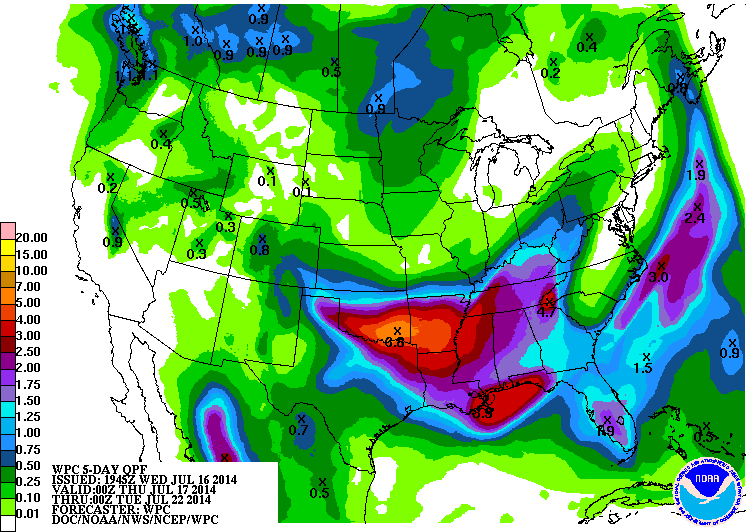
The latest from the WPC still has the heaviest rainfall totals centered over the Red River Valley. They have been remarkably consistent with this scenario for the past 5 days:

Image
0 likes   

User avatar
TheProfessor
Professional-Met
Professional-Met
Posts: 3506
Age: 28
Joined: Tue Dec 03, 2013 10:56 am
Location: Wichita, Kansas

#399 Postby TheProfessor » Wed Jul 16, 2014 4:17 pm

:uarrow: Well they could be right ( I'm hoping further south into Denton and Tarrant counties) but there have been many times where they would show my area getting 4-5+ inches of rain, only to under perform by 2-3 inches and the bullseye was somewhere else. I take them for a grain of salt now.
0 likes   
An alumnus of The Ohio State University.

Your local National Weather Service office is your best source for weather information.

aggiecutter
Category 5
Category 5
Posts: 1753
Joined: Thu Oct 14, 2004 9:22 pm
Location: Texarkana

Re: Texas Summer - 2014

#400 Postby aggiecutter » Wed Jul 16, 2014 7:23 pm

LarryCosgrove ‏@LarryCosgrove 12m
Looming severe weather, flooding rain threat N TX including Dallas, Tyler, and Texarkana Thursday into Saturday
0 likes   


Return to “USA & Caribbean Weather”

Who is online

Users browsing this forum: Google [Bot] and 6 guests