Texas Summer - 2014
Moderator: S2k Moderators
Forum rules
The posts in this forum are NOT official forecast and should not be used as such. They are just the opinion of the poster and may or may not be backed by sound meteorological data. They are NOT endorsed by any professional institution or STORM2K.
- tropicwatch
- Category 5

- Posts: 3426
- Age: 62
- Joined: Sat Jun 02, 2007 10:01 am
- Location: The Villages, Florida
- Contact:
Re: Texas Summer - 2014
That low hanging around the Texas/Mexico border could be interesting if it makes it to the gulf.


0 likes
Tropicwatch
Agnes 72', Eloise 75, Elena 85', Kate 85', Charley 86', Florence 88', Beryl 94', Dean 95', Erin 95', Opal 95', Earl 98', Georges 98', Ivan 2004', Arlene 2005', Dennis 2005', Ida 2009' Debby 2012' Irma 2017' Michael 2018'
Agnes 72', Eloise 75, Elena 85', Kate 85', Charley 86', Florence 88', Beryl 94', Dean 95', Erin 95', Opal 95', Earl 98', Georges 98', Ivan 2004', Arlene 2005', Dennis 2005', Ida 2009' Debby 2012' Irma 2017' Michael 2018'
-
texas1836
- Tropical Storm

- Posts: 223
- Age: 55
- Joined: Fri Aug 17, 2012 10:10 am
- Location: Ruidoso, New Mexico
Re: Texas Summer - 2014
wxman57 wrote:aggiecutter wrote:Looks like more cold is on the way:
http://i269.photobucket.com/albums/jj79/Photo44_album/Untitled_zps1dd3f34b.png
BRRR! Arctic cold in July!
I'm diggin' it and hope another couple more come in August.
0 likes
-
texas1836
- Tropical Storm

- Posts: 223
- Age: 55
- Joined: Fri Aug 17, 2012 10:10 am
- Location: Ruidoso, New Mexico
I’m leaving for Germany Saturday and the weather will much cooler, looking forward to it. I’m meeting my cousin who is a meteorologist in Vienna, I intend on sharing this website with him and giving him access to my weather station. Being he’s on another continent, is it ok for him to share info for our area? He does monitor the GFS and Euro in the states and he’s fascinated with the mid plains weather, says there’s no place like it on Earth.
0 likes
- TeamPlayersBlue
- Category 5

- Posts: 3531
- Joined: Tue Feb 02, 2010 1:44 am
- Location: Denver/Applewood, CO
If the Cold front doesnt make it to SE Tx, the humidity is gonna be cranked up for a few days no doubt. Probabaly means more rain for us though. Good thing.
0 likes
Personal Forecast Disclaimer:
The posts in this forum are NOT official forecast and should not be used as such. They are just the opinion of the poster and may or may not be backed by sound meteorological data. They are NOT endorsed by any professional institution or storm2k.org. For official information, please refer to the NHC and NWS products.
The posts in this forum are NOT official forecast and should not be used as such. They are just the opinion of the poster and may or may not be backed by sound meteorological data. They are NOT endorsed by any professional institution or storm2k.org. For official information, please refer to the NHC and NWS products.
- wxman57
- Moderator-Pro Met

- Posts: 23175
- Age: 68
- Joined: Sat Jun 21, 2003 8:06 pm
- Location: Houston, TX (southwest)
Re:
texas1836 wrote:I’m leaving for Germany Saturday and the weather will much cooler, looking forward to it. I’m meeting my cousin who is a meteorologist in Vienna, I intend on sharing this website with him and giving him access to my weather station. Being he’s on another continent, is it ok for him to share info for our area? He does monitor the GFS and Euro in the states and he’s fascinated with the mid plains weather, says there’s no place like it on Earth.
He's certainly welcome here.
0 likes
- Tireman4
- S2K Supporter

- Posts: 5903
- Age: 60
- Joined: Fri Jun 30, 2006 1:08 pm
- Location: Humble, Texas
- Contact:
Poor Man's Polar Vortex..?
Call it the ghost of the polar vortex, the polar vortex sequel, or the polar vortex’s revenge. Meteorological purists may tell you it’s not a polar vortex at all. However you choose to refer to the looming weather pattern, unseasonably chilly air is headed for parts of the northern and northeastern U.S at the height of summer early next week.
Bearing a haunting resemblance to January’s brutally cold weather pattern, a deep pool of cool air from the Gulf of Alaska will plunge into the Great Lakes early next week and then ooze towards the East Coast.
http://www.washingtonpost.com/blogs/cap ... next-week/
0 likes
This is really bizarre. It has a winter feel to it. Not temps obviously but tracking an airmass that will knock a good portion of the country below normal in the middle of summer! I wonder if record lows will be in danger in cities in the north and east. Will have to check Tropicanas daily record low posts next week. Can't remember the last time a front with this kind of strength swooping down on the eastern two thirds this late in the summer. Lovin it!!! And rain chances increasing as well. Great news for Texas.
0 likes
- Tireman4
- S2K Supporter

- Posts: 5903
- Age: 60
- Joined: Fri Jun 30, 2006 1:08 pm
- Location: Humble, Texas
- Contact:
Re:
gpsnowman wrote:This is really bizarre. It has a winter feel to it. Not temps obviously but tracking an airmass that will knock a good portion of the country below normal in the middle of summer! I wonder if record lows will be in danger in cities in the north and east. Will have to check Tropicanas daily record low posts next week. Can't remember the last time a front with this kind of strength swooping down on the eastern two thirds this late in the summer. Lovin it!!! And rain chances increasing as well. Great news for Texas.
Yep. Marquette, Michigan AFD mentioned that...
WHEN COMBINED WITH THE COLD AIRMASS OVERHEAD...HIGH TEMPS
MAY STRUGGLE TO GET ABOVE 50 IN SOME SPOTS ON TUE...WHICH WOULD BE
RECORD BREAKING FROM A MINIMUM HIGH TEMPERATURE PERSPECTIVE.
http://forecast.weather.gov/product.php ... glossary=1
0 likes
Re: Texas Summer - 2014
Folks the models are still beating the drum. We know a significant trough is going to take shape and strong cold front will come down. The latest ENS and OP guidance paint a very unique picture for the central and southern plains. If verified it would match something seen last year and daily low max and some mins maybe broken with heavy rain a possibility for many. Will be fascinating to see all this pan out as the pieces are already on the move. Strong Alaska/NW NA ridge (what's this? the -EPO?) is the catalyst, as a result of forcing from the WPAC (Neoguri) has set the stage. Now we wait to see if this is a highly unusual cool snap for July or something record breaking.
18z GFS has DFW raining and 70s late next week and Friday barely trying to get above 70. Some may push 50s/60s for lows. Just some crude raw data, approach with caution.


18z GFS has DFW raining and 70s late next week and Friday barely trying to get above 70. Some may push 50s/60s for lows. Just some crude raw data, approach with caution.


0 likes
The above post and any post by Ntxw is NOT an official forecast and should not be used as such. It is just the opinion of the poster and may or may not be backed by sound meteorological data. It is NOT endorsed by any professional institution including Storm2k. For official information, please refer to NWS products.
Re: Texas Summer - 2014
It's interesting that I'm going to fly to Wisconsin from Dallas on the 18th. Last year we flew up on the Sunday after Chicago had their all-time-lowest-July high temp of 65. We had a headwind and at 6000 ft MSL it was below freezing. If the 850 mb temps this year are colder than that, I'll be impressed.
0 likes
-
aggiecutter
- Category 5

- Posts: 1755
- Joined: Thu Oct 14, 2004 9:22 pm
- Location: Texarkana
Re: Texas Summer - 2014
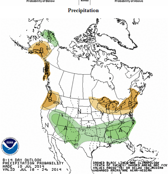
I'd like to see that higher than average precip area nudged a little further south and its quite possible it will once we get a better grasp on how far the front gets.

Looking forward to a very interesting week!
Looking forward to a very interesting week!
0 likes
Resident Rain Miser
I am a weather hobbyist living 3.5 miles south of Downtown Austin and in no way or fashion should anything I say concerning forecasts be taken seriously. Please check your local NWS for accurate weather forecasting and conditions.
I am a weather hobbyist living 3.5 miles south of Downtown Austin and in no way or fashion should anything I say concerning forecasts be taken seriously. Please check your local NWS for accurate weather forecasting and conditions.
- srainhoutx
- S2K Supporter

- Posts: 6919
- Age: 68
- Joined: Sun Jan 14, 2007 11:34 am
- Location: Haywood County, NC
- Contact:
Re: Texas Summer - 2014
The warmest weather of the summer season appears on tap this weekend as a robust upper Ridge develops across the Southern Plains. Subsidence, or sinking air should strongly inhibit any chance for much in the way of an isolate pop up pulsing shower along any sea/bay breeze that develops daily into Monday. Next Tuesday things begin to change and rather significantly.
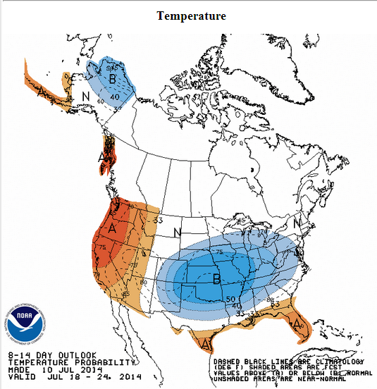
As we have mentioned, a rather unusual weather pattern develops with a potent spinning upper low with its origin across the Arctic and Northern Canada develops near the Great Lakes while the Upper Ridge is pushed W and noses well up into Western Canada carving a deep trough E of the Rockies and ushering in a Polar frontal boundary into the Plains. At the same time deep tropical moisture from the Caribbean Sea enters the Gulf of Mexico as well as moisture from monsoonal activity across Southern Arizona and New Mexico. As has been mentioned there does appear to be some upper level energy dropping SE in the NW flow aloft as well as embedded short wave energy from Mexico. While the various computer guidance remain somewhat mixed, there is rather good agreement that an anomalously cold pool of air by summertime standards drops S from Canada and enters the Southern Plains as well as the Lone Star State. The overnight operational and ensemble guidance suggest that anywhere between 2 to 3 standard deviations below normal daytime and night time temperatures may be possible later next week.
The major fly in the ointment is just where the frontal boundary will hang up or stall. Indications are that the front may stall N of I-10 and S of I-20 or across Central/East Texas and SW Louisiana. A daily push of outflow boundaries from convection along the front will greatly affect where the actual boundary stalls and the focal point of the heaviest rainfall will develop. Another aspect is the development of potential MCS (Mesoscale Convective Systems) upstream or across the Panhandle. With a NW flow aloft established, the movement would be SE toward Central/SE Texas and Louisiana. We just cannot predict with any accuracy if, when and where these potential convective complexes will develop this far in the future. The Weather Prediction Center 7 Day QPF is slowly but surely increasing each day across our Region as more data becomes available. While once Super Typhoon Neoguri is not directly involved in this pattern change, there are elements of that feature that are working in tandem to create a rather unusual mid-summer cold front. I would not be surprised to see rainfall forecast chances increase throughout the weekend for the Tuesday through next Friday time frame. As an interesting note, the analog dates that are at or near the top are July 1961. Those of us old enough to remember will recall an unusual summer cool spell before the SW Caribbean developed the ‘C’ storm around the first of September. Just an interesting tidbit, but certainly not a forecast.
0 likes
Carla/Alicia/Jerry(In The Eye)/Michelle/Charley/Ivan/Dennis/Katrina/Rita/Wilma/Ike/Harvey
Member: National Weather Association
Wx Infinity Forums
http://wxinfinity.com/index.php
Facebook.com/WeatherInfinity
Twitter @WeatherInfinity
Member: National Weather Association
Wx Infinity Forums
http://wxinfinity.com/index.php
Facebook.com/WeatherInfinity
Twitter @WeatherInfinity
- Portastorm
- Storm2k Moderator

- Posts: 9955
- Age: 63
- Joined: Fri Jul 11, 2003 9:16 am
- Location: Round Rock, TX
- Contact:
Re: Texas Summer - 2014
JDawg512 wrote:I'd like to see that higher than average precip area nudged a little further south and its quite possible it will once we get a better grasp on how far the front gets.
Looking forward to a very interesting week!
It's already "interesting" if you ask me. That pesky little upper level low in South Texas has nudged northwest enough that we're seeing some light showers in Travis County as of 9:20 a.m. and very cool surface temps. Lots of cloud cover, too. That was not in the forecast.
0 likes
Any forecasts under my name are to be taken with a grain of salt. Get your best forecasts from the National Weather Service and National Hurricane Center.
Looking at July as a whole, none of the four big metropolitan areas of Texas have yet to hit 100 this summer. This weekend is the last reasonable chance likely this month. The aforementioned cool spell next week is not a one day affair, several days and beyond guidance suggest below normal to normal temperatures lingering into the final week/week and half which then leads us to August. The summer, summer went on vacation.
0 likes
The above post and any post by Ntxw is NOT an official forecast and should not be used as such. It is just the opinion of the poster and may or may not be backed by sound meteorological data. It is NOT endorsed by any professional institution including Storm2k. For official information, please refer to NWS products.
- Tireman4
- S2K Supporter

- Posts: 5903
- Age: 60
- Joined: Fri Jun 30, 2006 1:08 pm
- Location: Humble, Texas
- Contact:
Our local OCM, Tim Heller ( from his Facebook page) does not think it will get through Houston.
A rare July cool front will plunge southward across the U.S. the middle of next week. Unseasonably cool temperatures are likely from the Midwest into the Deep South.
The cool front could push as far south as Dallas, but it probably won't reach Houston. The front will get close enough to produce widespread showers on Wednesday and Thursday, however. The clouds and rain will keep the temperatures down a few degrees, but don't expect it to be "cooler" around here.
I am not so sure about that. I wrote back and told him the models were still waffling on this.
0 likes
-
Ralph's Weather
- S2K Supporter

- Posts: 3371
- Age: 38
- Joined: Fri Dec 13, 2013 11:55 am
- Location: Lindale, TX
- Contact:
I typically only issue forecasts on Facebook during the winter, but this system has brought me to do one for the upcoming week. It really is more like a winter system anyway. I am conservatively calling for highs in the 70s late next week, but looking at the GFS even that could be too warm. Highs in the 70s would set record cool highs, but highs in the 60s would set all-time July records.
I cannot wait to watch this pattern evolve. Normally the only interesting weather would be the tropics so watching an Arctic airmass in July sure has my interest.
Here is what I am seeing to be the cause of this anomalous weather: -EPO enhanced by the typhoon amplifying the pattern enough to bring the Arctic air down into Texas combined with El Nino conditions providing Pacific moisture along with the typical Southwestern Monsoon. Plus a low around South Texas pulling in Caribbean moisture. Or basically a preview of what we expect to bring an amazing winter to Texas this year. I am excited just to have some rain and temps below 90, but I can handle being spoiled.
0 likes
Follow on Facebook at Ralph's Weather.
-
weatherdude1108
- Category 5

- Posts: 4228
- Joined: Tue Dec 13, 2011 1:04 pm
- Location: Northwest Austin/Cedar Park, TX
Re: Texas Summer - 2014
Portastorm wrote:JDawg512 wrote:I'd like to see that higher than average precip area nudged a little further south and its quite possible it will once we get a better grasp on how far the front gets.
Looking forward to a very interesting week!
It's already "interesting" if you ask me. That pesky little upper level low in South Texas has nudged northwest enough that we're seeing some light showers in Travis County as of 9:20 a.m. and very cool surface temps. Lots of cloud cover, too. That was not in the forecast.
I can verify that "interesting" fact. I was out walking on my work campus, and noticed I was getting wet, or dew was dropping from trees somewhere.
 I looked at the pavement and saw big drops of rain, with mostly cloudy skies. Not forecasted, but this is the kind of forecast "bust" I love, any day of the year.


0 likes
- Tireman4
- S2K Supporter

- Posts: 5903
- Age: 60
- Joined: Fri Jun 30, 2006 1:08 pm
- Location: Humble, Texas
- Contact:
Re: Texas Summer - 2014
Hey a new term!!
SummerPolarVortexmageddon II Will Bring Cooler Temperatures Next Week
Weeks after The Vane coined the defining term of summer 2014 — SummerPolarVortexmageddon — another huge cool-down is on tap for next week, and everyone is hopping on the "polar vortex" bandwagon. Imitation is the sincerest form of flattery.
A true polar vortex is essentially a big low pressure center that sits over the North Pole. Every once and a while, it will sort of break apart and turn into a group of smaller low pressure systems circling around the northern hemisphere. When one of these smaller low pressure centers — the "polar vortex" — spins over North America, it can bring exceptionally cold air to its victims and make everyone with an internet connection panic like cavemen seeing a comet for the first time.
What will happen next week is not a polar vortex. At best it's a Hudson Vortex. Manitobavex. But it is not a true polar vortex.
http://thevane.gawker.com/summerpolarvo ... 1603059623
0 likes
Return to “USA & Caribbean Weather”
Who is online
Users browsing this forum: A1A, AnnularCane and 129 guests


