Texas Summer - 2014

U.S. & Caribbean Weather Discussions and Severe Weather Events

Moderator: S2k Moderators

Forum rules

The posts in this forum are NOT official forecast and should not be used as such. They are just the opinion of the poster and may or may not be backed by sound meteorological data. They are NOT endorsed by any professional institution or STORM2K.

Help Support Storm2K
Message
Author
weatherdude1108
Category 5
Category 5
Posts: 4228
Joined: Tue Dec 13, 2011 1:04 pm
Location: Northwest Austin/Cedar Park, TX

#281 Postby weatherdude1108 » Mon Jul 07, 2014 4:08 pm

I'm already having a case of the Summer doldrums.
:break:

000
FXUS64 KEWX 071933
AFDEWX

AREA FORECAST DISCUSSION
NATIONAL WEATHER SERVICE AUSTIN/SAN ANTONIO TX
233 PM CDT MON JUL 7 2014

.SHORT TERM (TONIGHT THROUGH TUESDAY NIGHT)...
A PERSISTENCE FORECAST FOR MUCH OF THE FORECAST PERIOD. 500 MB
RIDGING OVER THE GREAT BASIN WILL KEEP HOLD OVER THE NEXT SEVERAL
DAYS WHILE ALSO TRYING TO BUILD A BIT EASTWARD INTO THE SOUTHERN
PLAINS.
AT LOWER LEVELS...FLOW FROM THE S AND SE WILL KEEP THE GULF
OF MEXICO MOISTURE IN PLACE AND KEEP TEMPS WHERE THEY HAVE
BEEN...MAINLY THE MIDDLE 90S. AS CONDITIONS CONTINUE TO DRY OUT DUE
TO THE SPOTTY NATURE OF THE RECENT RAIN ACTIVITY...OVERNIGHT LOWS
HAVE BEEN FAIRLY MILD AND DONT SEE ANY CHANGE IN THESE TEMPERATURES.
ONLY RAIN CHANCES THROUGH TUESDAY WILL BE ISOLATED AT BEST AND
CONCENTRATED OVER THE SE COUNTIES WHERE SEABREEZE CHANCES ARE
HIGHEST. COULD SEE A RETURN OF SOME MORNING LOW CLOUDS EARLY
TUESDAY MORNING BUT THESE ARE EXPECTED TO BURN OFF RATHER QUICKLY
COME TUESDAY AFTERNOON
.


&&

.LONG TERM (WEDNESDAY THROUGH MONDAY)...
LONG RANGE MODELS STILL DONT SHOW A WELL ESTABLISH UPPER RIDGE OVER
OUR AREA...AND UNTIL THAT OCCURS...THE MID TO UPPER 90S FORECAST
WITH ISOLATED POPS WILL BE THE FORECAST OF CHOICE
. THE GFS IS
SHOWING A SLUG OF MOISTURE COMING ONTO THE TEXAS COAST BY THURSDAY
WHICH MAY HELP TO TRIGGER A FEW MORE SH/TS ALONG THE SEABREEZE.
ALONG WITH THIS...THE MODELS ARE SHOWING A WEAKNESS IN THE 500 MB
HEIGHTS OVER SOUTH TEXAS AND GIVING US SLIGHTLY COOLER 850 TEMPS.
OUR CURRENT FORECAST HAS SLIGHT POP MENTIONED OVER THE SOUTHEAST
AND DONT PLAN ON CHANGING THIS PATTERN.
0 likes   
The preceding post is NOT an official forecast, and should not be used as such. It is only the opinion of the poster and may or may not be backed by sound meteorological data. It is NOT endorsed by any professional institution including storm2k.org. For Official Information please refer to the NHC and NWS products.

WeatherNewbie
Tropical Storm
Tropical Storm
Posts: 231
Joined: Mon Mar 22, 2010 3:42 pm
Location: Richardson, Texas

Re: Texas Summer - 2014

#282 Postby WeatherNewbie » Mon Jul 07, 2014 5:06 pm

Decent little popup shower over the Metroplex this afternoon.
0 likes   
The above post is NOT an official forecast and should not be used as such. It is just the opinion of the poster and may or may not be backed by sound meteorological data. It is NOT endorsed by any professional institution including storm2k.org. For official information, please refer to NWS products.

User avatar
Ntxw
Storm2k Moderator
Storm2k Moderator
Posts: 22784
Joined: Wed Oct 21, 2009 6:34 pm
Location: DFW, Texas

Re: Re:

#283 Postby Ntxw » Mon Jul 07, 2014 8:09 pm

TeamPlayersBlue wrote:
wxman57 wrote:
TeamPlayersBlue wrote:I dont think the Typhoon is expected to recurve. Does this rule still take effect? Its taking a much more northerly track vs a NE track.


Typhoon Neoguri is already recurving. Heading north toward southern Japan.


So is that the definition of recurveing? I thought it was 'recurving' when it exits the Japanese coast. Good to know! lol


It's not so much all the typhoon, the jist is the trough picking it up is being enhanced (feedback) by the system forcing stronger ridging to it's east. NA likely buckles a deeper trough especially east of the Rockies as a result. Euro is already hinting this with a fairly stout midwest/lakes low and trying to send a cold front (in July) towards Texas. Still a way to go but signs are there mid month.
0 likes   
The above post and any post by Ntxw is NOT an official forecast and should not be used as such. It is just the opinion of the poster and may or may not be backed by sound meteorological data. It is NOT endorsed by any professional institution including Storm2k. For official information, please refer to NWS products.

  Help support Storm2K!
Help Support Storm2K

User avatar
JDawg512
Category 5
Category 5
Posts: 1075
Age: 45
Joined: Mon Aug 26, 2013 8:56 pm
Location: Austin
Contact:

Re: Re:

#284 Postby JDawg512 » Tue Jul 08, 2014 3:46 am

Ntxw wrote:It's not so much all the typhoon, the jist is the trough picking it up is being enhanced (feedback) by the system forcing stronger ridging to it's east. NA likely buckles a deeper trough especially east of the Rockies as a result. Euro is already hinting this with a fairly stout midwest/lakes low and trying to send a cold front (in July) towards Texas. Still a way to go but signs are there mid month.


I sure hope so, what seemed like an unstable pattern for early July is turning out to be the opposite. Of course local news weather forecasts show no signs of rain for the next week. One channel I saw had 99 by the end of the week! Unless it is a heat ridge, I find it hard to believe it will get that hot as there is still good moisture in the ground and lots of greenery.
0 likes   
Resident Rain Miser

I am a weather hobbyist living 3.5 miles south of Downtown Austin and in no way or fashion should anything I say concerning forecasts be taken seriously. Please check your local NWS for accurate weather forecasting and conditions.

User avatar
Ntxw
Storm2k Moderator
Storm2k Moderator
Posts: 22784
Joined: Wed Oct 21, 2009 6:34 pm
Location: DFW, Texas

Re: Re:

#285 Postby Ntxw » Tue Jul 08, 2014 8:12 am

JDawg512 wrote:I sure hope so, what seemed like an unstable pattern for early July is turning out to be the opposite. Of course local news weather forecasts show no signs of rain for the next week. One channel I saw had 99 by the end of the week! Unless it is a heat ridge, I find it hard to believe it will get that hot as there is still good moisture in the ground and lots of greenery.


I'm afraid the heat wave this week is real centered to our west and will slowly migrate east just to the north. The northern half of the state will be closer to it and also received less rain than the southern 2/3rds. I think you're right the greenery is probably preventing it from becoming a multi week 100-105+ affair. There is likely a cold front coming towards the end of the heat wave sometime next week, timing needs to be fine tuned.

Climo climbs to 95-99 this period for many of us so heat would be considered slightly above average. Austin, San Antonio, Houston will be closer to normal. DFW may push over 100.
0 likes   
The above post and any post by Ntxw is NOT an official forecast and should not be used as such. It is just the opinion of the poster and may or may not be backed by sound meteorological data. It is NOT endorsed by any professional institution including Storm2k. For official information, please refer to NWS products.


  Help support Storm2K!

Help Support Storm2K


User avatar
Tireman4
S2K Supporter
S2K Supporter
Posts: 5853
Age: 59
Joined: Fri Jun 30, 2006 1:08 pm
Location: Humble, Texas
Contact:

Re: Re:

#286 Postby Tireman4 » Tue Jul 08, 2014 11:31 am

Ntxw wrote:
JDawg512 wrote:I sure hope so, what seemed like an unstable pattern for early July is turning out to be the opposite. Of course local news weather forecasts show no signs of rain for the next week. One channel I saw had 99 by the end of the week! Unless it is a heat ridge, I find it hard to believe it will get that hot as there is still good moisture in the ground and lots of greenery.


I'm afraid the heat wave this week is real centered to our west and will slowly migrate east just to the north. The northern half of the state will be closer to it and also received less rain than the southern 2/3rds. I think you're right the greenery is probably preventing it from becoming a multi week 100-105+ affair. There is likely a cold front coming towards the end of the heat wave sometime next week, timing needs to be fine tuned.

Climo climbs to 95-99 this period for many of us so heat would be considered slightly above average. Austin, San Antonio, Houston will be closer to normal. DFW may push over 100.


Huh? Tell me more....
0 likes   

User avatar
TeamPlayersBlue
Category 5
Category 5
Posts: 3445
Joined: Tue Feb 02, 2010 1:44 am
Location: Denver/Applewood, CO

#287 Postby TeamPlayersBlue » Tue Jul 08, 2014 12:14 pm

Check out Bastardis latest tweet. "Summer version of the Polar Vortex" to the Great Lakes.
0 likes   
Personal Forecast Disclaimer:
The posts in this forum are NOT official forecast and should not be used as such. They are just the opinion of the poster and may or may not be backed by sound meteorological data. They are NOT endorsed by any professional institution or storm2k.org. For official information, please refer to the NHC and NWS products.

User avatar
Portastorm
Storm2k Moderator
Storm2k Moderator
Posts: 9914
Age: 63
Joined: Fri Jul 11, 2003 9:16 am
Location: Round Rock, TX
Contact:

Re: Texas Summer - 2014

#288 Postby Portastorm » Wed Jul 09, 2014 11:17 am

Caught this interesting little blurb from this morning's AFD out of NWSFO EWX:

BEYOND THIS FORECAST...THE EASTERN STATES UPPER LEVEL LOW DEEPENS
FORCING THE SUBTROPICAL RIDGE BACK WEST ALLOWING A COLD FRONT TO
MOVE INTO TEXAS MID TO LATE NEXT WEEK. THE ECMWF DROPS THE FRONT
INTO SOUTH CENTRAL TEXAS BRINGING CHANCES OF SHOWERS AND
THUNDERSTORMS WHILE THE GFS KEEPS THE FRONT NORTH OF OUR AREA WITH
A DRY FORECAST.
0 likes   
Any forecasts under my name are to be taken with a grain of salt. Get your best forecasts from the National Weather Service and National Hurricane Center.

weatherdude1108
Category 5
Category 5
Posts: 4228
Joined: Tue Dec 13, 2011 1:04 pm
Location: Northwest Austin/Cedar Park, TX

Re: Texas Summer - 2014

#289 Postby weatherdude1108 » Wed Jul 09, 2014 11:40 am

Portastorm wrote:Caught this interesting little blurb from this morning's AFD out of NWSFO EWX:

BEYOND THIS FORECAST...THE EASTERN STATES UPPER LEVEL LOW DEEPENS
FORCING THE SUBTROPICAL RIDGE BACK WEST ALLOWING A COLD FRONT TO
MOVE INTO TEXAS MID TO LATE NEXT WEEK. THE ECMWF DROPS THE FRONT
INTO SOUTH CENTRAL TEXAS BRINGING CHANCES OF SHOWERS AND
THUNDERSTORMS WHILE THE GFS KEEPS THE FRONT NORTH OF OUR AREA WITH
A DRY FORECAST.


I saw that too. Let's hope something comes of it! I know it is approaching mid-July and all, but, we all know -- anything can happen. :)
0 likes   

User avatar
ravyrn
S2K Supporter
S2K Supporter
Posts: 1000
Age: 42
Joined: Sun Aug 31, 2008 5:10 am
Location: Alderbranch, TX

Re: Texas Summer - 2014

#290 Postby ravyrn » Wed Jul 09, 2014 11:56 am

Perhaps we should enlist SaskatchewanScreamer and her trusty fans to make sure that front makes it down here?
0 likes   

User avatar
Tireman4
S2K Supporter
S2K Supporter
Posts: 5853
Age: 59
Joined: Fri Jun 30, 2006 1:08 pm
Location: Humble, Texas
Contact:

#291 Postby Tireman4 » Wed Jul 09, 2014 12:41 pm

I know we had a cold front come to Texas in August 2004 (13-15). I know because that was my wedding day back then. It does happen. Now, on the flip side, we had the hottest October ever...LOL.
0 likes   

texas1836
Tropical Storm
Tropical Storm
Posts: 223
Age: 55
Joined: Fri Aug 17, 2012 10:10 am
Location: Ruidoso, New Mexico

#292 Postby texas1836 » Wed Jul 09, 2014 1:21 pm

Wow, Fall in July.
0 likes   

User avatar
somethingfunny
ChatStaff
ChatStaff
Posts: 3926
Age: 37
Joined: Thu May 31, 2007 10:30 pm
Location: McKinney, Texas

Re: Texas Summer - 2014

#293 Postby somethingfunny » Wed Jul 09, 2014 1:51 pm

The sucky thing about summer cold fronts is that in cases when they stall out just north of us, the heat and humidity collect right up against the boundary and just make things more miserable when the front fails to clear the area. Our long hot summer has begun and I'll be pessimistic until October.
0 likes   
I am not a meteorologist, and any posts made by me are not official forecasts or to be interpreted as being intelligent. These posts are just my opinions and are probably silly opinions.

User avatar
wxman57
Moderator-Pro Met
Moderator-Pro Met
Posts: 22978
Age: 67
Joined: Sat Jun 21, 2003 8:06 pm
Location: Houston, TX (southwest)

Re: Texas Summer - 2014

#294 Postby wxman57 » Wed Jul 09, 2014 2:13 pm

Summer is turning out pretty much as I'd expected - cooler than normal across SE TX and wetter. Houston's running about 1.3F below normal temperature-wise so far in July (June was normal). Rainfall is catching up to normal after a dry spring. I have measured just over 20" (25" is normal). That 10.4" in May helped a lot. Even though temps are below normal, I find July tolerable as low 90s is still warm enough to bike. ;-)

Image
0 likes   

aggiecutter
Category 5
Category 5
Posts: 1753
Joined: Thu Oct 14, 2004 9:22 pm
Location: Texarkana

Re: Texas Summer - 2014

#295 Postby aggiecutter » Wed Jul 09, 2014 3:12 pm

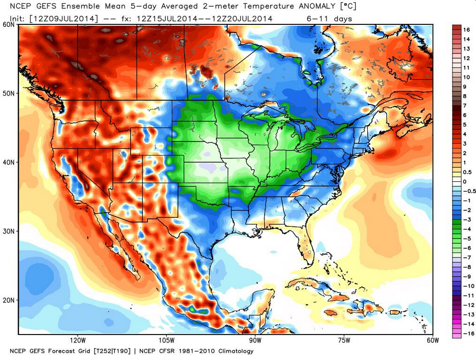
Looks like more cold is on the way:

Image
0 likes   

User avatar
Ntxw
Storm2k Moderator
Storm2k Moderator
Posts: 22784
Joined: Wed Oct 21, 2009 6:34 pm
Location: DFW, Texas

#296 Postby Ntxw » Wed Jul 09, 2014 6:45 pm

Euro is looking quite bullish. For July that is a pretty good front, and less hot air mass. If you recall last mid July we had a once in a lifetime cool shot mid July. Probably not that kind of intensity, but it's looking pretty darn good. Even the less hopeful GFS has been going cooler, example 18z has some areas in the 70s and low 80s with rain like the Canadian. Of course you're still talking a week away. Regardless, we picked this potential pattern out some days ago and the models have gradually begun to fine tune.

FW AFD this afternoon


BOTH THE GFS...ECMWF...AND CANADIAN ARE IN BETTER AGREEMENT ON
THEIR LATEST RUNS THAT THE UPPER LEVEL RIDGE WILL BE FORCED BACK
WEST DURING THE EARLY PART OF NEXT WEEK AS A STRONG UPPER LEVEL
LOW AND ASSOCIATED TROUGH DROPS INTO THE GREAT LAKES AND
NORTHEASTERN CONUS AREAS. THE WEAKENING OF THE RIDGE OVER THE
REGION SHOULD ALLOW FOR SLIGHTLY COOLER TEMPERATURES BY THE MIDDLE
OF NEXT WEEK BUT ALL THREE MODELS ALSO ADVERTISE A STRONG FRONT
MOVING ACROSS THE REGION NEXT WEEK. THE CANADIAN IS THE FASTEST
WITH THE FRONTAL ARRIVAL...BRINGING IT IN ON MONDAY WHILE THE
ECMWF HAS THE FRONT ON WEDNESDAY AND THE GFS HAS IT ON THURSDAY.
WILL TREND TOWARDS THE SLOWER ARRIVAL TIME WHICH IS JUST BEYOND
THE REACH OF THIS FORECAST PERIOD BUT THE MODELS ARE ADVERTISING
COOLER TEMPERATURES AND RAIN WITH THIS FRONT.
0 likes   
The above post and any post by Ntxw is NOT an official forecast and should not be used as such. It is just the opinion of the poster and may or may not be backed by sound meteorological data. It is NOT endorsed by any professional institution including Storm2k. For official information, please refer to NWS products.


  Help support Storm2K!

Help Support Storm2K


User avatar
wxman57
Moderator-Pro Met
Moderator-Pro Met
Posts: 22978
Age: 67
Joined: Sat Jun 21, 2003 8:06 pm
Location: Houston, TX (southwest)

Re: Texas Summer - 2014

#297 Postby wxman57 » Wed Jul 09, 2014 8:27 pm

aggiecutter wrote:Looks like more cold is on the way:

http://i269.photobucket.com/albums/jj79/Photo44_album/Untitled_zps1dd3f34b.png


BRRR! Arctic cold in July! :cold:
0 likes   

User avatar
Ntxw
Storm2k Moderator
Storm2k Moderator
Posts: 22784
Joined: Wed Oct 21, 2009 6:34 pm
Location: DFW, Texas

Re: Texas Summer - 2014

#298 Postby Ntxw » Wed Jul 09, 2014 10:52 pm

Dr Ventrice tweeted this.

"Michael Ventrice ‏@MJVentrice
20-25F below average temperatures across the Plains next week under a big time cold front. Top 5% cool spell in store pic.twitter.com/rpTTzCX8Rc"


Image


That typhoon recurve theory meant business
0 likes   
The above post and any post by Ntxw is NOT an official forecast and should not be used as such. It is just the opinion of the poster and may or may not be backed by sound meteorological data. It is NOT endorsed by any professional institution including Storm2k. For official information, please refer to NWS products.


  Help support Storm2K!

Help Support Storm2K


weatherdude1108
Category 5
Category 5
Posts: 4228
Joined: Tue Dec 13, 2011 1:04 pm
Location: Northwest Austin/Cedar Park, TX

#299 Postby weatherdude1108 » Wed Jul 09, 2014 11:37 pm

:rain: Bob Rose mentioned the cold front, rain, and cooler temps in today's blog. :D :cold:

http://www.lcra.org/water/river-and-wea ... ather.aspx
0 likes   
The preceding post is NOT an official forecast, and should not be used as such. It is only the opinion of the poster and may or may not be backed by sound meteorological data. It is NOT endorsed by any professional institution including storm2k.org. For Official Information please refer to the NHC and NWS products.

User avatar
Ntxw
Storm2k Moderator
Storm2k Moderator
Posts: 22784
Joined: Wed Oct 21, 2009 6:34 pm
Location: DFW, Texas

Re: Texas Summer - 2014

#300 Postby Ntxw » Thu Jul 10, 2014 7:26 am

Some remarkable agreement by the models. FW is starting to buy into the idea. Good flow for persistent rains, MCS from NW to SSE one after another in that kind of pattern. Summer doesn't offer these type of drastic pattern amplifications much, except for monster heat ridges this one is going the other direction. Probably a 2-4 SD below normal in our region and even greater just up north. Pretty rare event if panned.

The words strong cold front and July are not supposed to be

Image
0 likes   
The above post and any post by Ntxw is NOT an official forecast and should not be used as such. It is just the opinion of the poster and may or may not be backed by sound meteorological data. It is NOT endorsed by any professional institution including Storm2k. For official information, please refer to NWS products.


  Help support Storm2K!

Help Support Storm2K


Return to “USA & Caribbean Weather”

Who is online

Users browsing this forum: No registered users and 6 guests